![Route and Surveys of the Southern Journey Party, 1908–1909 (1909) by England: Royal Geographic Society. Original from…]() Route and Surveys of the Southern Journey Party, 1908–1909 (1909) by England: Royal Geographic Society. Original from…
Route and Surveys of the Southern Journey Party, 1908–1909 (1909) by England: Royal Geographic Society. Original from…![Philips' war map of the Pacific (1945) by George Philip and Son Limited. Original from The Beinecke Rare Book & Manuscript…]() Philips' war map of the Pacific (1945) by George Philip and Son Limited. Original from The Beinecke Rare Book & Manuscript…
Philips' war map of the Pacific (1945) by George Philip and Son Limited. Original from The Beinecke Rare Book & Manuscript…![Stanford's Compendium of Geography and Travel based on Hellwald's “Die Erde und ihre Völker” (1878) by Edward…]() Stanford's Compendium of Geography and Travel based on Hellwald's “Die Erde und ihre Völker” (1878) by Edward…
Stanford's Compendium of Geography and Travel based on Hellwald's “Die Erde und ihre Völker” (1878) by Edward…![Orient Line Guide. Chapters for travellers by sea and by land (1885) by William John Loftie. Original from British Library.…]() Orient Line Guide. Chapters for travellers by sea and by land (1885) by William John Loftie. Original from British Library.…
Orient Line Guide. Chapters for travellers by sea and by land (1885) by William John Loftie. Original from British Library.…![View of portion of Queensland, Australia from Skylab space station. Original from NASA. Digitally enhanced by rawpixel]() View of portion of Queensland, Australia from Skylab space station. Original from NASA. Digitally enhanced by rawpixel
View of portion of Queensland, Australia from Skylab space station. Original from NASA. Digitally enhanced by rawpixel![Poster "Irish Free State & Northern Ireland" (1929) by MacDonald Gil. Original from Museum of New Zealand. Digitally…]() Poster "Irish Free State & Northern Ireland" (1929) by MacDonald Gil. Original from Museum of New Zealand. Digitally…
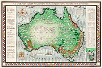
Poster "Irish Free State & Northern Ireland" (1929) by MacDonald Gil. Original from Museum of New Zealand. Digitally…![Poster "A Map of New Zealand" (1913) by MacDonald Gil. Original from Museum of New Zealand. Digitally enhanced by rawpixel.]() Poster "A Map of New Zealand" (1913) by MacDonald Gil. Original from Museum of New Zealand. Digitally enhanced by rawpixel.
Poster "A Map of New Zealand" (1913) by MacDonald Gil. Original from Museum of New Zealand. Digitally enhanced by rawpixel.![World map (1900) by Diogo Ribeiro. Original from The Beinecke Rare Book & Manuscript Library. Digitally enhanced by rawpixel.]() World map (1900) by Diogo Ribeiro. Original from The Beinecke Rare Book & Manuscript Library. Digitally enhanced by rawpixel.
World map (1900) by Diogo Ribeiro. Original from The Beinecke Rare Book & Manuscript Library. Digitally enhanced by rawpixel.![Strategic map of Central Europe showing the international frontiers / prepared in the War College Division (1915) by Arch.…]() Strategic map of Central Europe showing the international frontiers / prepared in the War College Division (1915) by Arch.…
Strategic map of Central Europe showing the international frontiers / prepared in the War College Division (1915) by Arch.…![清 佚名 台南地區荷蘭城堡 Forts Zeelandia and Provintia and the City of Tainan (ca. 1900s) by anonymous. Original from The MET Museum.…]() 清 佚名 台南地區荷蘭城堡 Forts Zeelandia and Provintia and the City of Tainan (ca. 1900s) by anonymous. Original from The MET Museum.…
清 佚名 台南地區荷蘭城堡 Forts Zeelandia and Provintia and the City of Tainan (ca. 1900s) by anonymous. Original from The MET Museum.…![Noordpool (ca. 1869–1907) by Nijgh & Van Ditmar. Original from The Rijksmuseum. Digitally enhanced by rawpixel.]() Noordpool (ca. 1869–1907) by Nijgh & Van Ditmar. Original from The Rijksmuseum. Digitally enhanced by rawpixel.
Noordpool (ca. 1869–1907) by Nijgh & Van Ditmar. Original from The Rijksmuseum. Digitally enhanced by rawpixel.![Zum Weltkrieg 1914! (1914) by W. Karnahl. Original from The Beinecke Rare Book & Manuscript Library. Digitally enhanced by…]() Zum Weltkrieg 1914! (1914) by W. Karnahl. Original from The Beinecke Rare Book & Manuscript Library. Digitally enhanced by…
Zum Weltkrieg 1914! (1914) by W. Karnahl. Original from The Beinecke Rare Book & Manuscript Library. Digitally enhanced by…![Chart of the Great Barrier Reef Area from The Great Barrier Reef of Australia (1893) by William Saville-Kent (1845-1908).…]() Chart of the Great Barrier Reef Area from The Great Barrier Reef of Australia (1893) by William Saville-Kent (1845-1908).…
Chart of the Great Barrier Reef Area from The Great Barrier Reef of Australia (1893) by William Saville-Kent (1845-1908).…![The Voyages of Captain James Cook (1852) by James Cook. Original from British Library. Digitally enhanced by rawpixel.]() The Voyages of Captain James Cook (1852) by James Cook. Original from British Library. Digitally enhanced by rawpixel.
The Voyages of Captain James Cook (1852) by James Cook. Original from British Library. Digitally enhanced by rawpixel.![Color plan of the 1942 Rome World's Fair (1939) by Arti grafiche Pizzi & Pizio. Original from The Beinecke Rare Book &…]() Color plan of the 1942 Rome World's Fair (1939) by Arti grafiche Pizzi & Pizio. Original from The Beinecke Rare Book &…
Color plan of the 1942 Rome World's Fair (1939) by Arti grafiche Pizzi & Pizio. Original from The Beinecke Rare Book &…![Wereldkaart Mapemonde planisphere ou carte generale du monde (1735) from Daniel de Lafeuilledelete. Original from The…]() Wereldkaart Mapemonde planisphere ou carte generale du monde (1735) from Daniel de Lafeuilledelete. Original from The…
Wereldkaart Mapemonde planisphere ou carte generale du monde (1735) from Daniel de Lafeuilledelete. Original from The…![British Islands approximate positions of minefields (1918) by William Rea Furlong. Original from Library of Congress.…]() British Islands approximate positions of minefields (1918) by William Rea Furlong. Original from Library of Congress.…
British Islands approximate positions of minefields (1918) by William Rea Furlong. Original from Library of Congress.…![New York City, photographed from two miles up in the air (1922) from The Lionel Pincus and Princess Firyal Map Division.…]() New York City, photographed from two miles up in the air (1922) from The Lionel Pincus and Princess Firyal Map Division.…
New York City, photographed from two miles up in the air (1922) from The Lionel Pincus and Princess Firyal Map Division.…![New York City, photographed from two miles up in the air (1922) from The Lionel Pincus and Princess Firyal Map Division.…]() New York City, photographed from two miles up in the air (1922) from The Lionel Pincus and Princess Firyal Map Division.…
New York City, photographed from two miles up in the air (1922) from The Lionel Pincus and Princess Firyal Map Division.…![Up-to-date map of the world war (1942) by Manila Shinbun-sha. Original from The Beinecke Rare Book & Manuscript Library.…]() Up-to-date map of the world war (1942) by Manila Shinbun-sha. Original from The Beinecke Rare Book & Manuscript Library.…
Up-to-date map of the world war (1942) by Manila Shinbun-sha. Original from The Beinecke Rare Book & Manuscript Library.…![Colton's Map of the World on Mercator's Projection (1858) by J.H. Colton & Co. Original from The Beinecke Rare Book &…]() Colton's Map of the World on Mercator's Projection (1858) by J.H. Colton & Co. Original from The Beinecke Rare Book &…
Colton's Map of the World on Mercator's Projection (1858) by J.H. Colton & Co. Original from The Beinecke Rare Book &…![Typus orbis terrarum (1587–1595) by Abraham Ortelius. Original From The New York Public Library. Digitally enhanced by…]() Typus orbis terrarum (1587–1595) by Abraham Ortelius. Original From The New York Public Library. Digitally enhanced by…
Typus orbis terrarum (1587–1595) by Abraham Ortelius. Original From The New York Public Library. Digitally enhanced by…![Nova totius terrarum orbis geographica ac hydrographica (ca. 1635–1650) by Guiljelmo Blaeuw. Original from The…]() Nova totius terrarum orbis geographica ac hydrographica (ca. 1635–1650) by Guiljelmo Blaeuw. Original from The…
Nova totius terrarum orbis geographica ac hydrographica (ca. 1635–1650) by Guiljelmo Blaeuw. Original from The…![Bacon's standard map of Europe by George Washington Bacon (1830–1922). Original from Library of Congress. Digitally…]() Bacon's standard map of Europe by George Washington Bacon (1830–1922). Original from Library of Congress. Digitally…
Bacon's standard map of Europe by George Washington Bacon (1830–1922). Original from Library of Congress. Digitally…![New York City, photographed from two miles up in the air (1922) from The Lionel Pincus and Princess Firyal Map Division.…]() New York City, photographed from two miles up in the air (1922) from The Lionel Pincus and Princess Firyal Map Division.…
New York City, photographed from two miles up in the air (1922) from The Lionel Pincus and Princess Firyal Map Division.…![New York City, photographed from two miles up in the air (1922) from The Lionel Pincus and Princess Firyal Map Division.…]() New York City, photographed from two miles up in the air (1922) from The Lionel Pincus and Princess Firyal Map Division.…
New York City, photographed from two miles up in the air (1922) from The Lionel Pincus and Princess Firyal Map Division.…![A new map of the world according to the new observations (1732) by Herman Moll. Original from The Beinecke Rare Book &…]() A new map of the world according to the new observations (1732) by Herman Moll. Original from The Beinecke Rare Book &…
A new map of the world according to the new observations (1732) by Herman Moll. Original from The Beinecke Rare Book &…![Vlakke aard-kloot met het beide hemelsch half-rond, of de onder scheidene verbeelding van de land-water-waereld (1709) by…]() Vlakke aard-kloot met het beide hemelsch half-rond, of de onder scheidene verbeelding van de land-water-waereld (1709) by…
Vlakke aard-kloot met het beide hemelsch half-rond, of de onder scheidene verbeelding van de land-water-waereld (1709) by…![A Map of the World from the best Authorities (1795) from Carey's American Edition of Guthrie's Geography Improved. Original…]() A Map of the World from the best Authorities (1795) from Carey's American Edition of Guthrie's Geography Improved. Original…
A Map of the World from the best Authorities (1795) from Carey's American Edition of Guthrie's Geography Improved. Original…![Mappa totius mundi: adornata juxta observationes (1682) by Guilielmum de l'Isle. Original from The Beinecke Rare Book &…]() Mappa totius mundi: adornata juxta observationes (1682) by Guilielmum de l'Isle. Original from The Beinecke Rare Book &…
Mappa totius mundi: adornata juxta observationes (1682) by Guilielmum de l'Isle. Original from The Beinecke Rare Book &…![Description generale du globe terrestre et aquatique en deux-plans-hemispheres (1691) by Alexis-Hubert Jaillot and Nicolas…]() Description generale du globe terrestre et aquatique en deux-plans-hemispheres (1691) by Alexis-Hubert Jaillot and Nicolas…
Description generale du globe terrestre et aquatique en deux-plans-hemispheres (1691) by Alexis-Hubert Jaillot and Nicolas…![New world or western hemisphere: old world or eastern hemisphere (1786) by William Faden. Original from The Beinecke Rare…]() New world or western hemisphere: old world or eastern hemisphere (1786) by William Faden. Original from The Beinecke Rare…
New world or western hemisphere: old world or eastern hemisphere (1786) by William Faden. Original from The Beinecke Rare…![Vlakke aard-kloot gemeenlyk genaamd de geheele waereld (1696) by Carel Allard. Original from The Beinecke Rare Book &…]() Vlakke aard-kloot gemeenlyk genaamd de geheele waereld (1696) by Carel Allard. Original from The Beinecke Rare Book &…
Vlakke aard-kloot gemeenlyk genaamd de geheele waereld (1696) by Carel Allard. Original from The Beinecke Rare Book &…![Planiglobii terrestris mappa vniversalis (1746) by George Moritz, Johann Matthias Hase, and Homann Erben. Original from The…]() Planiglobii terrestris mappa vniversalis (1746) by George Moritz, Johann Matthias Hase, and Homann Erben. Original from The…
Planiglobii terrestris mappa vniversalis (1746) by George Moritz, Johann Matthias Hase, and Homann Erben. Original from The…![Mappa totius mundi : adornata juxta observationes dnn. academiae regalis scientiarum et nonnullorum aliorum secundum…]() Mappa totius mundi : adornata juxta observationes dnn. academiae regalis scientiarum et nonnullorum aliorum secundum…
Mappa totius mundi : adornata juxta observationes dnn. academiae regalis scientiarum et nonnullorum aliorum secundum…![Bowles's new pocket map of the world: laid down from the latest observations and comprehending the new discoveries to the…]() Bowles's new pocket map of the world: laid down from the latest observations and comprehending the new discoveries to the…
Bowles's new pocket map of the world: laid down from the latest observations and comprehending the new discoveries to the…![A mapp of the world (1682) by John Playford. Original From The New York Public Library. Digitally enhanced by rawpixel.]() A mapp of the world (1682) by John Playford. Original From The New York Public Library. Digitally enhanced by rawpixel.
A mapp of the world (1682) by John Playford. Original From The New York Public Library. Digitally enhanced by rawpixel.![New World, or, Western Hemisphere; Old World, or Eastern Hemisphere (1790) by William Faden. Original From The New York…]() New World, or, Western Hemisphere; Old World, or Eastern Hemisphere (1790) by William Faden. Original From The New York…
New World, or, Western Hemisphere; Old World, or Eastern Hemisphere (1790) by William Faden. Original From The New York…![Orbis terrae compendiosa descriptio : quam ex magna universali Gerardi Mercatoris Domino Richardo Gartho, geographie ac…]() Orbis terrae compendiosa descriptio : quam ex magna universali Gerardi Mercatoris Domino Richardo Gartho, geographie ac…
Orbis terrae compendiosa descriptio : quam ex magna universali Gerardi Mercatoris Domino Richardo Gartho, geographie ac…![Mappe Monde ou Carte générale de l'Univers (1782) by Mathieu Albert Lotter. Original from The Beinecke Rare Book &…]() Mappe Monde ou Carte générale de l'Univers (1782) by Mathieu Albert Lotter. Original from The Beinecke Rare Book &…
Mappe Monde ou Carte générale de l'Univers (1782) by Mathieu Albert Lotter. Original from The Beinecke Rare Book &…![Mappa mondo o vero carta generale del globo terrestre (1674) by N. Sanson de Abbeville. Original from The Beinecke Rare Book…]() Mappa mondo o vero carta generale del globo terrestre (1674) by N. Sanson de Abbeville. Original from The Beinecke Rare Book…
Mappa mondo o vero carta generale del globo terrestre (1674) by N. Sanson de Abbeville. Original from The Beinecke Rare Book…![Nova totius terrarum orbis geographica ac hydrographica tabula (1635–1649) by Jan Aertse van den Ende. Original from…]() Nova totius terrarum orbis geographica ac hydrographica tabula (1635–1649) by Jan Aertse van den Ende. Original from…
Nova totius terrarum orbis geographica ac hydrographica tabula (1635–1649) by Jan Aertse van den Ende. Original from…![Johnson's Western Hemisphere [and] Johnson's Eastern Hemisphere (1866) by Johnson and Ward. Original from The Beinecke Rare…]() Johnson's Western Hemisphere [and] Johnson's Eastern Hemisphere (1866) by Johnson and Ward. Original from The Beinecke Rare…
Johnson's Western Hemisphere [and] Johnson's Eastern Hemisphere (1866) by Johnson and Ward. Original from The Beinecke Rare…![Die Erde. Eine allgemeine Erd- und Länderkunde, etc (1896) by Franz Heiderich. Original from British Library. Digitally…]() Die Erde. Eine allgemeine Erd- und Länderkunde, etc (1896) by Franz Heiderich. Original from British Library. Digitally…
Die Erde. Eine allgemeine Erd- und Länderkunde, etc (1896) by Franz Heiderich. Original from British Library. Digitally…![Nova & accuratissima totius terrarum orbis tabula nautica variationum magneticarum index juxta observationes Anno 1700…]() Nova & accuratissima totius terrarum orbis tabula nautica variationum magneticarum index juxta observationes Anno 1700…
Nova & accuratissima totius terrarum orbis tabula nautica variationum magneticarum index juxta observationes Anno 1700…![Nieuwe Werelt kaert (1672) by Goos Pieter. Original From The New York Public Library. Digitally enhanced by rawpixel.]() Nieuwe Werelt kaert (1672) by Goos Pieter. Original From The New York Public Library. Digitally enhanced by rawpixel.
Nieuwe Werelt kaert (1672) by Goos Pieter. Original From The New York Public Library. Digitally enhanced by rawpixel.![Nova et accuratissima totius terrarum orbis tabula (ca. 1648–1664) by Joan Blaeu. Original From The New York Public…]() Nova et accuratissima totius terrarum orbis tabula (ca. 1648–1664) by Joan Blaeu. Original From The New York Public…
Nova et accuratissima totius terrarum orbis tabula (ca. 1648–1664) by Joan Blaeu. Original From The New York Public…![Map sampler made at Pleasent Valley Quaker Boarding School (1809) by Polly Platt. Original from The MET Museum. Digitally…]() Map sampler made at Pleasent Valley Quaker Boarding School (1809) by Polly Platt. Original from The MET Museum. Digitally…
Map sampler made at Pleasent Valley Quaker Boarding School (1809) by Polly Platt. Original from The MET Museum. Digitally…![Die beyden Halbkugeln der Erde (1807) by Schneider und Weigelsehen. Original from The Beinecke Rare Book & Manuscript…]() Die beyden Halbkugeln der Erde (1807) by Schneider und Weigelsehen. Original from The Beinecke Rare Book & Manuscript…
Die beyden Halbkugeln der Erde (1807) by Schneider und Weigelsehen. Original from The Beinecke Rare Book & Manuscript…![Planiglobii Terrestris Mappa Universalis (1746) by Johann Baptist Homann. Original from The MET Museum. Digitally enhanced…]() Planiglobii Terrestris Mappa Universalis (1746) by Johann Baptist Homann. Original from The MET Museum. Digitally enhanced…
Planiglobii Terrestris Mappa Universalis (1746) by Johann Baptist Homann. Original from The MET Museum. Digitally enhanced…![Map of the New York world's fair and approaches (ca. 1939–1940) from The Lionel Pincus and Princess Firyal Map…]() Map of the New York world's fair and approaches (ca. 1939–1940) from The Lionel Pincus and Princess Firyal Map…
Map of the New York world's fair and approaches (ca. 1939–1940) from The Lionel Pincus and Princess Firyal Map…![A Cyclopedia of Geography, descriptive and physical, forming a new general gazetteer of the world and dictionary of…]() A Cyclopedia of Geography, descriptive and physical, forming a new general gazetteer of the world and dictionary of…
A Cyclopedia of Geography, descriptive and physical, forming a new general gazetteer of the world and dictionary of…![Hand drawn globe illustration]() Hand drawn globe illustration
Hand drawn globe illustration![Vintage globe illustration]() Vintage globe illustration
Vintage globe illustration![Hand drawn globe vintage illustration]() Hand drawn globe vintage illustration
Hand drawn globe vintage illustration![New twelve inch terrestrial globe (ca. 1891) by Rand McNally & Company. Original from Library of Congress. Digitally…]() New twelve inch terrestrial globe (ca. 1891) by Rand McNally & Company. Original from Library of Congress. Digitally…
New twelve inch terrestrial globe (ca. 1891) by Rand McNally & Company. Original from Library of Congress. Digitally…![Pocket world map vintage illustration wall art print and poster design remix from original artwork.]() Pocket world map vintage illustration wall art print and poster design remix from original artwork.
Pocket world map vintage illustration wall art print and poster design remix from original artwork.![Globe collage element, hand drawn vintage illustration psd]() Globe collage element, hand drawn vintage illustration psd
Globe collage element, hand drawn vintage illustration psd![Globe collage element, hand drawn vintage illustration psd]() Globe collage element, hand drawn vintage illustration psd
Globe collage element, hand drawn vintage illustration psd![Hand drawn collage element, vintage illustration psd]() Hand drawn collage element, vintage illustration psd
Hand drawn collage element, vintage illustration psd![Western Hemisphere map vintage illustration, remix from original artwork.]() Western Hemisphere map vintage illustration, remix from original artwork.
Western Hemisphere map vintage illustration, remix from original artwork.![Png globe sticker, hand drawn vintage illustration, transparent background]() Png globe sticker, hand drawn vintage illustration, transparent background
Png globe sticker, hand drawn vintage illustration, transparent background![Png globe sticker, hand drawn illustration, transparent background]() Png globe sticker, hand drawn illustration, transparent background
Png globe sticker, hand drawn illustration, transparent background![Hand drawn world vintage illustration on torn paper]() Hand drawn world vintage illustration on torn paper
Hand drawn world vintage illustration on torn paper![Hand drawn globe vintage illustration on torn paper]() Hand drawn globe vintage illustration on torn paper
Hand drawn globe vintage illustration on torn paper![Png globe sticker, hand drawn vintage illustration, transparent background]() Png globe sticker, hand drawn vintage illustration, transparent background
Png globe sticker, hand drawn vintage illustration, transparent background![Hand drawn world vintage illustration on torn paper]() Hand drawn world vintage illustration on torn paper
Hand drawn world vintage illustration on torn paper![A map of the world on a globular projection : exhibiting particularly the nautical researches of Captain James Cook, F.R.S.…]() A map of the world on a globular projection : exhibiting particularly the nautical researches of Captain James Cook, F.R.S.…
A map of the world on a globular projection : exhibiting particularly the nautical researches of Captain James Cook, F.R.S.…![A map of the world on a globular projection : exhibiting particularly the nautical researches of Captain James Cook, F.R.S.…]() A map of the world on a globular projection : exhibiting particularly the nautical researches of Captain James Cook, F.R.S.…
A map of the world on a globular projection : exhibiting particularly the nautical researches of Captain James Cook, F.R.S.…![Rapid transit map of Manhattan and adjacent districts of New York City (1908) by Rand McNally and Company. Original from…]() Rapid transit map of Manhattan and adjacent districts of New York City (1908) by Rand McNally and Company. Original from…
Rapid transit map of Manhattan and adjacent districts of New York City (1908) by Rand McNally and Company. Original from…![Western Hemisphere map vintage illustration, remix from original artwork.]() Western Hemisphere map vintage illustration, remix from original artwork.
Western Hemisphere map vintage illustration, remix from original artwork.![Pocket world map vintage illustration, remix from original artwork.]() Pocket world map vintage illustration, remix from original artwork.
Pocket world map vintage illustration, remix from original artwork.![Earth illustration, vintage artwork]() Earth illustration, vintage artwork
Earth illustration, vintage artwork![Earth illustration, vintage artwork, ripped paper badge]() Earth illustration, vintage artwork, ripped paper badge
Earth illustration, vintage artwork, ripped paper badge![Pocket world map vintage illustration vector, remix from original artwork.]() Pocket world map vintage illustration vector, remix from original artwork.
Pocket world map vintage illustration vector, remix from original artwork.![Png globe sticker, vintage illustration, transparent background]() Png globe sticker, vintage illustration, transparent background
Png globe sticker, vintage illustration, transparent background![Png hand drawn globe sticker, vintage illustration on ripped paper, transparent background]() Png hand drawn globe sticker, vintage illustration on ripped paper, transparent background
Png hand drawn globe sticker, vintage illustration on ripped paper, transparent background![Png hand drawn world sticker, vintage illustration on ripped paper, transparent background]() Png hand drawn world sticker, vintage illustration on ripped paper, transparent background
Png hand drawn world sticker, vintage illustration on ripped paper, transparent background![Png hand drawn world sticker, vintage illustration on ripped paper, transparent background]() Png hand drawn world sticker, vintage illustration on ripped paper, transparent background
Png hand drawn world sticker, vintage illustration on ripped paper, transparent background![Every southern spring and summer, after the Sun has risen into its 24-hour circuit around the skies of Antarctica, the Ross…]() Every southern spring and summer, after the Sun has risen into its 24-hour circuit around the skies of Antarctica, the Ross…
Every southern spring and summer, after the Sun has risen into its 24-hour circuit around the skies of Antarctica, the Ross…![Western Hemisphere map vintage illustration, remix from original artwork.]() Western Hemisphere map vintage illustration, remix from original artwork.
Western Hemisphere map vintage illustration, remix from original artwork.![Western Hemisphere map vintage illustration wall art print and poster design remix from original artwork.]() Western Hemisphere map vintage illustration wall art print and poster design remix from original artwork.
Western Hemisphere map vintage illustration wall art print and poster design remix from original artwork.![Earth illustration, vintage artwork]() Earth illustration, vintage artwork
Earth illustration, vintage artwork![Great Barrier Reef Echinoderms from The Great Barrier Reef of Australia (1893) by William Saville-Kent (1845-1908).]() Great Barrier Reef Echinoderms from The Great Barrier Reef of Australia (1893) by William Saville-Kent (1845-1908).
Great Barrier Reef Echinoderms from The Great Barrier Reef of Australia (1893) by William Saville-Kent (1845-1908). ![Portolan atlas of the Mediterranean Sea, western Europe, and the northwest coast of Africa: World map drawn on an oval…]() Portolan atlas of the Mediterranean Sea, western Europe, and the northwest coast of Africa: World map drawn on an oval…
Portolan atlas of the Mediterranean Sea, western Europe, and the northwest coast of Africa: World map drawn on an oval…![Map of Kyoto (1863) by Takebara Kahei. Original from The Beinecke Rare Book & Manuscript Library. Digitally enhanced by…]() Map of Kyoto (1863) by Takebara Kahei. Original from The Beinecke Rare Book & Manuscript Library. Digitally enhanced by…
Map of Kyoto (1863) by Takebara Kahei. Original from The Beinecke Rare Book & Manuscript Library. Digitally enhanced by…![Geography of the British Isles from ten different standpoints, with twenty-one maps (1886) by Thomas McLaren Davidson.…]() Geography of the British Isles from ten different standpoints, with twenty-one maps (1886) by Thomas McLaren Davidson.…
Geography of the British Isles from ten different standpoints, with twenty-one maps (1886) by Thomas McLaren Davidson.…![The First and Second Battles of Newbury and the Siege of Donnington Castle during the Civil War, A.D. 1643–1646 (1881)…]() The First and Second Battles of Newbury and the Siege of Donnington Castle during the Civil War, A.D. 1643–1646 (1881)…
The First and Second Battles of Newbury and the Siege of Donnington Castle during the Civil War, A.D. 1643–1646 (1881)…![Kaart van de noordkust van Engeland bij Newcastle upon Tyne (1580–1583) by Joannes van Doetechum (I). Original from…]() Kaart van de noordkust van Engeland bij Newcastle upon Tyne (1580–1583) by Joannes van Doetechum (I). Original from…
Kaart van de noordkust van Engeland bij Newcastle upon Tyne (1580–1583) by Joannes van Doetechum (I). Original from…![Map of New York and vicinity (1875) by Matthew Dripps. Original from The Beinecke Rare Book & Manuscript Library. Digitally…]() Map of New York and vicinity (1875) by Matthew Dripps. Original from The Beinecke Rare Book & Manuscript Library. Digitally…
Map of New York and vicinity (1875) by Matthew Dripps. Original from The Beinecke Rare Book & Manuscript Library. Digitally…![Kaart van Nederland met de marsroutes van het Franse leger (1792) by Cornelis van Baarsel. Original from The Rijksmuseum.…]() Kaart van Nederland met de marsroutes van het Franse leger (1792) by Cornelis van Baarsel. Original from The Rijksmuseum.…
Kaart van Nederland met de marsroutes van het Franse leger (1792) by Cornelis van Baarsel. Original from The Rijksmuseum.…![Map of Alexandria (1575) by Georg Braun. Original from The MET Museum. Digitally enhanced by rawpixel.]() Map of Alexandria (1575) by Georg Braun. Original from The MET Museum. Digitally enhanced by rawpixel.
Map of Alexandria (1575) by Georg Braun. Original from The MET Museum. Digitally enhanced by rawpixel.![View of Antwerp from Braun and Hogenberg's Civitates Orbis Terrarum (1572–1594) designed by Joris Hoefnagel and edited…]() View of Antwerp from Braun and Hogenberg's Civitates Orbis Terrarum (1572–1594) designed by Joris Hoefnagel and edited…
View of Antwerp from Braun and Hogenberg's Civitates Orbis Terrarum (1572–1594) designed by Joris Hoefnagel and edited…![Kaart van het zuidelijke deel van Zuid-Amerika (1750–1760) by Guillaume Delisle. Original from The Rijksmuseum.…]() Kaart van het zuidelijke deel van Zuid-Amerika (1750–1760) by Guillaume Delisle. Original from The Rijksmuseum.…
Kaart van het zuidelijke deel van Zuid-Amerika (1750–1760) by Guillaume Delisle. Original from The Rijksmuseum.…![Map of Vienna (ca. 1702) by Johann-Baptista Homann. Original from Yale University Art Gallery. Digitally enhanced by…]() Map of Vienna (ca. 1702) by Johann-Baptista Homann. Original from Yale University Art Gallery. Digitally enhanced by…
Map of Vienna (ca. 1702) by Johann-Baptista Homann. Original from Yale University Art Gallery. Digitally enhanced by…![Getekende kaart van de Franse linies in Brabant (ca. 1705) by anonymous. Original from The Rijksmuseum. Digitally enhanced…]() Getekende kaart van de Franse linies in Brabant (ca. 1705) by anonymous. Original from The Rijksmuseum. Digitally enhanced…
Getekende kaart van de Franse linies in Brabant (ca. 1705) by anonymous. Original from The Rijksmuseum. Digitally enhanced…![Les Isles Britanniques: ou sont le Royaume d'Angleterre tire ́de Sped celuy d'Ecosse tire ́de Th. Pont et celuy d'Irlande…]() Les Isles Britanniques: ou sont le Royaume d'Angleterre tire ́de Sped celuy d'Ecosse tire ́de Th. Pont et celuy d'Irlande…
Les Isles Britanniques: ou sont le Royaume d'Angleterre tire ́de Sped celuy d'Ecosse tire ́de Th. Pont et celuy d'Irlande…![Kaartje van Kaap de Goede Hoop (1595) by anonymous. Original from The Rijksmuseum. Digitally enhanced by rawpixel.]() Kaartje van Kaap de Goede Hoop (1595) by anonymous. Original from The Rijksmuseum. Digitally enhanced by rawpixel.
Kaartje van Kaap de Goede Hoop (1595) by anonymous. Original from The Rijksmuseum. Digitally enhanced by rawpixel.![Map of Africa (1722). Original from The Beinecke Rare Book & Manuscript Library. Digitally enhanced by rawpixel.]() Map of Africa (1722). Original from The Beinecke Rare Book & Manuscript Library. Digitally enhanced by rawpixel.
Map of Africa (1722). Original from The Beinecke Rare Book & Manuscript Library. Digitally enhanced by rawpixel.![Map of China (1848) by James Wyld. Original from The Beinecke Rare Book & Manuscript Library. Digitally enhanced by rawpixel.]() Map of China (1848) by James Wyld. Original from The Beinecke Rare Book & Manuscript Library. Digitally enhanced by rawpixel.
Map of China (1848) by James Wyld. Original from The Beinecke Rare Book & Manuscript Library. Digitally enhanced by rawpixel.