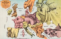
![Latest war map of Europe : as seen through French eyes / / perpared by Hadol, in Paris., L. Prang & Co., publisher]() Latest war map of Europe : as seen through French eyes / / perpared by Hadol, in Paris., L. Prang & Co., publisher
Latest war map of Europe : as seen through French eyes / / perpared by Hadol, in Paris., L. Prang & Co., publisher![Different figures representing a map of the countries of Europe in 1870. Coloured lithograph after P.J. Hadol.]() Different figures representing a map of the countries of Europe in 1870. Coloured lithograph after P.J. Hadol.
Different figures representing a map of the countries of Europe in 1870. Coloured lithograph after P.J. Hadol.![Satirische kaart van Europa in 1870 (1870) by Paul Hadol and Imprimerie Vallée]() Satirische kaart van Europa in 1870 (1870) by Paul Hadol and Imprimerie Vallée
Satirische kaart van Europa in 1870 (1870) by Paul Hadol and Imprimerie Vallée![Latest war map of Europe : as seen through French eyes (1870) by L. Prang & Co.]() Latest war map of Europe : as seen through French eyes (1870) by L. Prang & Co.
Latest war map of Europe : as seen through French eyes (1870) by L. Prang & Co.![Saint Paul of the Cross. Line engraving by G.B. Leonetti after A. Tofanelli.]() Saint Paul of the Cross. Line engraving by G.B. Leonetti after A. Tofanelli.
Saint Paul of the Cross. Line engraving by G.B. Leonetti after A. Tofanelli.![Bacon's standard map of Europe by George Washington Bacon (1830–1922). Original from Library of Congress. Digitally…]() Bacon's standard map of Europe by George Washington Bacon (1830–1922). Original from Library of Congress. Digitally…
Bacon's standard map of Europe by George Washington Bacon (1830–1922). Original from Library of Congress. Digitally…![British Islands approximate positions of minefields (1918) by William Rea Furlong. Original from Library of Congress.…]() British Islands approximate positions of minefields (1918) by William Rea Furlong. Original from Library of Congress.…
British Islands approximate positions of minefields (1918) by William Rea Furlong. Original from Library of Congress.…![A new and accurat map of the world drawne according to ye truest descriptions latest discoveries & best…]() A new and accurat map of the world drawne according to ye truest descriptions latest discoveries & best…
A new and accurat map of the world drawne according to ye truest descriptions latest discoveries & best…![Colton's Map of the World on Mercator's Projection (1858) by J.H. Colton & Co. Original from The Beinecke Rare Book &…]() Colton's Map of the World on Mercator's Projection (1858) by J.H. Colton & Co. Original from The Beinecke Rare Book &…
Colton's Map of the World on Mercator's Projection (1858) by J.H. Colton & Co. Original from The Beinecke Rare Book &…![World atlas from Voyeur's Checklist, General Notions Of Mathematical Geography, Physical Geography, Political Geography…]() World atlas from Voyeur's Checklist, General Notions Of Mathematical Geography, Physical Geography, Political Geography…
World atlas from Voyeur's Checklist, General Notions Of Mathematical Geography, Physical Geography, Political Geography…![World atlas from Voyeur's Checklist, General Notions Of Mathematical Geography, Physical Geography, Political Geography…]() World atlas from Voyeur's Checklist, General Notions Of Mathematical Geography, Physical Geography, Political Geography…
World atlas from Voyeur's Checklist, General Notions Of Mathematical Geography, Physical Geography, Political Geography…![Map of France, Spain, and Portugal; Switzerland in cantons [inset]; Island of Corsica (1863) by Samuel Augustus Mitchell.…]() Map of France, Spain, and Portugal; Switzerland in cantons [inset]; Island of Corsica (1863) by Samuel Augustus Mitchell.…
Map of France, Spain, and Portugal; Switzerland in cantons [inset]; Island of Corsica (1863) by Samuel Augustus Mitchell.…![World atlas from The Practical Teaching of Geography. Atlas, Maps, Texts and Questionnaires... Elementary Course (1878).…]() World atlas from The Practical Teaching of Geography. Atlas, Maps, Texts and Questionnaires... Elementary Course (1878).…
World atlas from The Practical Teaching of Geography. Atlas, Maps, Texts and Questionnaires... Elementary Course (1878).…![Bowles's new pocket map of the world: laid down from the latest observations and comprehending the new discoveries to the…]() Bowles's new pocket map of the world: laid down from the latest observations and comprehending the new discoveries to the…
Bowles's new pocket map of the world: laid down from the latest observations and comprehending the new discoveries to the…![Johnson's Western Hemisphere [and] Johnson's Eastern Hemisphere (1866) by Johnson and Ward. Original from The Beinecke Rare…]() Johnson's Western Hemisphere [and] Johnson's Eastern Hemisphere (1866) by Johnson and Ward. Original from The Beinecke Rare…
Johnson's Western Hemisphere [and] Johnson's Eastern Hemisphere (1866) by Johnson and Ward. Original from The Beinecke Rare…![Die Erde. Eine allgemeine Erd- und Länderkunde, etc (1896) by Franz Heiderich. Original from British Library. Digitally…]() Die Erde. Eine allgemeine Erd- und Länderkunde, etc (1896) by Franz Heiderich. Original from British Library. Digitally…
Die Erde. Eine allgemeine Erd- und Länderkunde, etc (1896) by Franz Heiderich. Original from British Library. Digitally…![World atlas from Voyeur's Checklist, General Notions Of Mathematical Geography, Physical Geography, Political Geography…]() World atlas from Voyeur's Checklist, General Notions Of Mathematical Geography, Physical Geography, Political Geography…
World atlas from Voyeur's Checklist, General Notions Of Mathematical Geography, Physical Geography, Political Geography…![World atlas from The Practical Teaching of Geography. Atlas, Maps, Texts and Questionnaires... Elementary Course (1878).…]() World atlas from The Practical Teaching of Geography. Atlas, Maps, Texts and Questionnaires... Elementary Course (1878).…
World atlas from The Practical Teaching of Geography. Atlas, Maps, Texts and Questionnaires... Elementary Course (1878).…![Map sampler made at Pleasent Valley Quaker Boarding School (1809) by Polly Platt. Original from The MET Museum. Digitally…]() Map sampler made at Pleasent Valley Quaker Boarding School (1809) by Polly Platt. Original from The MET Museum. Digitally…
Map sampler made at Pleasent Valley Quaker Boarding School (1809) by Polly Platt. Original from The MET Museum. Digitally…![Die beyden Halbkugeln der Erde (1807) by Schneider und Weigelsehen. Original from The Beinecke Rare Book & Manuscript…]() Die beyden Halbkugeln der Erde (1807) by Schneider und Weigelsehen. Original from The Beinecke Rare Book & Manuscript…
Die beyden Halbkugeln der Erde (1807) by Schneider und Weigelsehen. Original from The Beinecke Rare Book & Manuscript…![The Voyages of Captain James Cook (1852) by James Cook. Original from British Library. Digitally enhanced by rawpixel.]() The Voyages of Captain James Cook (1852) by James Cook. Original from British Library. Digitally enhanced by rawpixel.
The Voyages of Captain James Cook (1852) by James Cook. Original from British Library. Digitally enhanced by rawpixel.![World atlas from The Practical Teaching of Geography. Atlas, Maps, Texts and Questionnaires... Elementary Course (1878).…]() World atlas from The Practical Teaching of Geography. Atlas, Maps, Texts and Questionnaires... Elementary Course (1878).…
World atlas from The Practical Teaching of Geography. Atlas, Maps, Texts and Questionnaires... Elementary Course (1878).…![World atlas from The Practical Teaching of Geography. Atlas, Maps, Texts and Questionnaires... Elementary Course (1878).…]() World atlas from The Practical Teaching of Geography. Atlas, Maps, Texts and Questionnaires... Elementary Course (1878).…
World atlas from The Practical Teaching of Geography. Atlas, Maps, Texts and Questionnaires... Elementary Course (1878).…![World map from A System of Geography, for the use of Schools (1860) published by Sidney Edwards Morse. Original from the…]() World map from A System of Geography, for the use of Schools (1860) published by Sidney Edwards Morse. Original from the…
World map from A System of Geography, for the use of Schools (1860) published by Sidney Edwards Morse. Original from the…![World map from A System of Geography, for the use of Schools (1860) published by Sidney Edwards Morse. Original from the…]() World map from A System of Geography, for the use of Schools (1860) published by Sidney Edwards Morse. Original from the…
World map from A System of Geography, for the use of Schools (1860) published by Sidney Edwards Morse. Original from the…![World atlas from Voyeur's Checklist, General Notions Of Mathematical Geography, Physical Geography, Political Geography…]() World atlas from Voyeur's Checklist, General Notions Of Mathematical Geography, Physical Geography, Political Geography…
World atlas from Voyeur's Checklist, General Notions Of Mathematical Geography, Physical Geography, Political Geography…![A Burmese map of the world, showing traces of Medieval European map-making from The thirty-seven nats : a phase of spirit…]() A Burmese map of the world, showing traces of Medieval European map-making from The thirty-seven nats : a phase of spirit…
A Burmese map of the world, showing traces of Medieval European map-making from The thirty-seven nats : a phase of spirit…![A Cyclopedia of Geography, descriptive and physical, forming a new general gazetteer of the world and dictionary of…]() A Cyclopedia of Geography, descriptive and physical, forming a new general gazetteer of the world and dictionary of…
A Cyclopedia of Geography, descriptive and physical, forming a new general gazetteer of the world and dictionary of…![Papagallo no.15 la Piovra Russa Anno VI by Augusto Grossi (1835-1919), a cartoon depiction of Europe in 1878, using…]() Papagallo no.15 la Piovra Russa Anno VI by Augusto Grossi (1835-1919), a cartoon depiction of Europe in 1878, using…
Papagallo no.15 la Piovra Russa Anno VI by Augusto Grossi (1835-1919), a cartoon depiction of Europe in 1878, using…![Historical First World War battle sites around Liege, Belgium and Verdun, France. Original public domain image from Flickr]() Historical First World War battle sites around Liege, Belgium and Verdun, France. Original public domain image from Flickr
Historical First World War battle sites around Liege, Belgium and Verdun, France. Original public domain image from Flickr![Landscape in Auvers (Paysage à Auvers) (1883) by Paul Cézanne. Original from Yale University Art Gallery.…]() Landscape in Auvers (Paysage à Auvers) (1883) by Paul Cézanne. Original from Yale University Art Gallery.…
Landscape in Auvers (Paysage à Auvers) (1883) by Paul Cézanne. Original from Yale University Art Gallery.…![Landscape at Auvers (1873) by Paul Cézanne. Original from The Art Institute of Chicago. Digitally enhanced by…]() Landscape at Auvers (1873) by Paul Cézanne. Original from The Art Institute of Chicago. Digitally enhanced by…
Landscape at Auvers (1873) by Paul Cézanne. Original from The Art Institute of Chicago. Digitally enhanced by…![A new, plaine & exact map of Europe : described by N.I. Visscher and done into English, enlarged & corrected…]() A new, plaine & exact map of Europe : described by N.I. Visscher and done into English, enlarged & corrected…
A new, plaine & exact map of Europe : described by N.I. Visscher and done into English, enlarged & corrected…![The House of Dr. Gachet in Auvers-sur-Oise (ca. 1872–1873) by Paul Cézanne. Original from Yale University Art…]() The House of Dr. Gachet in Auvers-sur-Oise (ca. 1872–1873) by Paul Cézanne. Original from Yale University Art…
The House of Dr. Gachet in Auvers-sur-Oise (ca. 1872–1873) by Paul Cézanne. Original from Yale University Art…![Auvers, Panoramic View (ca. 1873–1875) by Paul Cézanne. Original from The Art Institute of Chicago. Digitally…]() Auvers, Panoramic View (ca. 1873–1875) by Paul Cézanne. Original from The Art Institute of Chicago. Digitally…
Auvers, Panoramic View (ca. 1873–1875) by Paul Cézanne. Original from The Art Institute of Chicago. Digitally…![Montagne Sainte-Victoire, from near Gardanne (ca. 1887) by Paul Cézanne. Original from The National Gallery of Art.…]() Montagne Sainte-Victoire, from near Gardanne (ca. 1887) by Paul Cézanne. Original from The National Gallery of Art.…
Montagne Sainte-Victoire, from near Gardanne (ca. 1887) by Paul Cézanne. Original from The National Gallery of Art.…![The Brook (ca. 1895–900) by Paul Cézanne. Original from The Cleveland Museum of Art. Digitally enhanced by…]() The Brook (ca. 1895–900) by Paul Cézanne. Original from The Cleveland Museum of Art. Digitally enhanced by…
The Brook (ca. 1895–900) by Paul Cézanne. Original from The Cleveland Museum of Art. Digitally enhanced by…![Bibémus (ca. 1894–1895) by Paul Cézanne. Original from Original from Barnes Foundation. Digitally…]() Bibémus (ca. 1894–1895) by Paul Cézanne. Original from Original from Barnes Foundation. Digitally…
Bibémus (ca. 1894–1895) by Paul Cézanne. Original from Original from Barnes Foundation. Digitally…![House in Provence (Maison en Provence) (ca.1890) by Paul Cézanne. Original from Original from Barnes Foundation.…]() House in Provence (Maison en Provence) (ca.1890) by Paul Cézanne. Original from Original from Barnes Foundation.…
House in Provence (Maison en Provence) (ca.1890) by Paul Cézanne. Original from Original from Barnes Foundation.…![Gardanne (Horizontal View) (Gardanne [vue horizontale]) (ca. 1885) by Paul Cézanne. Original from Original from…]() Gardanne (Horizontal View) (Gardanne [vue horizontale]) (ca. 1885) by Paul Cézanne. Original from Original from…
Gardanne (Horizontal View) (Gardanne [vue horizontale]) (ca. 1885) by Paul Cézanne. Original from Original from…![The Allée at Marines (L'Allée de Marines) (ca. 1898) by Paul Cézanne. Original from Original from…]() The Allée at Marines (L'Allée de Marines) (ca. 1898) by Paul Cézanne. Original from Original from…
The Allée at Marines (L'Allée de Marines) (ca. 1898) by Paul Cézanne. Original from Original from…![Banks of the Seine at Médan (ca. 1880–1885) by Paul Cézanne. Original from The National Gallery of Art.…]() Banks of the Seine at Médan (ca. 1880–1885) by Paul Cézanne. Original from The National Gallery of Art.…
Banks of the Seine at Médan (ca. 1880–1885) by Paul Cézanne. Original from The National Gallery of Art.…![A map of the kingdom of Scotland from the latest and best observations, for Mr. Tindal's Continuation of Mr.…]() A map of the kingdom of Scotland from the latest and best observations, for Mr. Tindal's Continuation of Mr.…
A map of the kingdom of Scotland from the latest and best observations, for Mr. Tindal's Continuation of Mr.…![The Bay of Marseille, Seen from L’Estaque (ca. 1885) by Paul Cézanne. Original from The Art Institute of…]() The Bay of Marseille, Seen from L’Estaque (ca. 1885) by Paul Cézanne. Original from The Art Institute of…
The Bay of Marseille, Seen from L’Estaque (ca. 1885) by Paul Cézanne. Original from The Art Institute of…![Bathers at Rest (Baigneurs au repos) (ca. 1876–1877) by Paul Cézanne. Original from Original from Barnes…]() Bathers at Rest (Baigneurs au repos) (ca. 1876–1877) by Paul Cézanne. Original from Original from Barnes…
Bathers at Rest (Baigneurs au repos) (ca. 1876–1877) by Paul Cézanne. Original from Original from Barnes…![A Village Road near Auvers (ca. 1872–1873) by Paul Cézanne. Original from Yale University Art Gallery.…]() A Village Road near Auvers (ca. 1872–1873) by Paul Cézanne. Original from Yale University Art Gallery.…
A Village Road near Auvers (ca. 1872–1873) by Paul Cézanne. Original from Yale University Art Gallery.…![Trees and Road (Arbres et route) (1890) by Paul Cézanne. Original from Barnes Foundation. Digitally enhanced by…]() Trees and Road (Arbres et route) (1890) by Paul Cézanne. Original from Barnes Foundation. Digitally enhanced by…
Trees and Road (Arbres et route) (1890) by Paul Cézanne. Original from Barnes Foundation. Digitally enhanced by…![Church at Montigny-sur-Loing (L'Église de Montigny-sur-Loing) (1898) by Paul Cézanne. Original from Barnes…]() Church at Montigny-sur-Loing (L'Église de Montigny-sur-Loing) (1898) by Paul Cézanne. Original from Barnes…
Church at Montigny-sur-Loing (L'Église de Montigny-sur-Loing) (1898) by Paul Cézanne. Original from Barnes…![Mont Sainte-Victoire (La Montagne Sainte-Victoire) (ca. 1892–1895) by Paul Cézanne. Original from Original from…]() Mont Sainte-Victoire (La Montagne Sainte-Victoire) (ca. 1892–1895) by Paul Cézanne. Original from Original from…
Mont Sainte-Victoire (La Montagne Sainte-Victoire) (ca. 1892–1895) by Paul Cézanne. Original from Original from…![The Pigeon Tower at Bellevue (1890) by Paul Cézanne. Original from The Cleveland Museum of Art. Digitally enhanced by…]() The Pigeon Tower at Bellevue (1890) by Paul Cézanne. Original from The Cleveland Museum of Art. Digitally enhanced by…
The Pigeon Tower at Bellevue (1890) by Paul Cézanne. Original from The Cleveland Museum of Art. Digitally enhanced by…![The Pool at Jas de Bouffan (ca. 1885–1886) by Paul Cézanne. Original from The MET Museum. Digitally enhanced by…]() The Pool at Jas de Bouffan (ca. 1885–1886) by Paul Cézanne. Original from The MET Museum. Digitally enhanced by…
The Pool at Jas de Bouffan (ca. 1885–1886) by Paul Cézanne. Original from The MET Museum. Digitally enhanced by…![Kaart van het oorlogsterrein van Zuid-Frankrijk en Noord-Italië in 1859 (1859) by H Scheve, A J Lastdrager, van and Gorter…]() Kaart van het oorlogsterrein van Zuid-Frankrijk en Noord-Italië in 1859 (1859) by H Scheve, A J Lastdrager, van and Gorter…
Kaart van het oorlogsterrein van Zuid-Frankrijk en Noord-Italië in 1859 (1859) by H Scheve, A J Lastdrager, van and Gorter…![Kaart van Corsica (1735) by anonymous and erven J Ratelband and Co]() Kaart van Corsica (1735) by anonymous and erven J Ratelband and Co
Kaart van Corsica (1735) by anonymous and erven J Ratelband and Co![Memorial of German military events from the year 1702. Engraving, c. 1722.]() Memorial of German military events from the year 1702. Engraving, c. 1722.
Memorial of German military events from the year 1702. Engraving, c. 1722.![Zum Weltkrieg 1914! (1914) by W. Karnahl. Original from The Beinecke Rare Book & Manuscript Library. Digitally enhanced by…]() Zum Weltkrieg 1914! (1914) by W. Karnahl. Original from The Beinecke Rare Book & Manuscript Library. Digitally enhanced by…
Zum Weltkrieg 1914! (1914) by W. Karnahl. Original from The Beinecke Rare Book & Manuscript Library. Digitally enhanced by…![Memorial of European events from the year 1719. Engraving, c. 1722.]() Memorial of European events from the year 1719. Engraving, c. 1722.
Memorial of European events from the year 1719. Engraving, c. 1722.![Mont Sainte-Victoire and the Viaduct of the Arc River Valley (ca. 1882–1885) by Paul Cézanne. Original from The…]() Mont Sainte-Victoire and the Viaduct of the Arc River Valley (ca. 1882–1885) by Paul Cézanne. Original from The…
Mont Sainte-Victoire and the Viaduct of the Arc River Valley (ca. 1882–1885) by Paul Cézanne. Original from The…![The Farm at the Jas de Bouffan (La Ferme au Jas de Bouffan) (ca. 1887) by Paul Cézanne. Original from Original from…]() The Farm at the Jas de Bouffan (La Ferme au Jas de Bouffan) (ca. 1887) by Paul Cézanne. Original from Original from…
The Farm at the Jas de Bouffan (La Ferme au Jas de Bouffan) (ca. 1887) by Paul Cézanne. Original from Original from…![A new mapp of America devided according to the best and latest observations and discoveries wherein are…]() A new mapp of America devided according to the best and latest observations and discoveries wherein are…
A new mapp of America devided according to the best and latest observations and discoveries wherein are…![Memorial of European events from the year 1721. Engraving, c. 1722.]() Memorial of European events from the year 1721. Engraving, c. 1722.
Memorial of European events from the year 1721. Engraving, c. 1722.![Ukraine flag map sticker, geography illustration vector. Free public domain CC0 image.]() Ukraine flag map sticker, geography illustration vector. Free public domain CC0 image.
Ukraine flag map sticker, geography illustration vector. Free public domain CC0 image.![Map of Zeppelin and aeroplane bombs on London. From: World War I photograph album (1919) by Herbert Green. Original from…]() Map of Zeppelin and aeroplane bombs on London. From: World War I photograph album (1919) by Herbert Green. Original from…
Map of Zeppelin and aeroplane bombs on London. From: World War I photograph album (1919) by Herbert Green. Original from…![A map of Europe, and the countries bordering on the Mediterranean & Black Seas, from the latest authorities …]() A map of Europe, and the countries bordering on the Mediterranean & Black Seas, from the latest authorities …
A map of Europe, and the countries bordering on the Mediterranean & Black Seas, from the latest authorities …![Philips' war map of the Pacific (1945) by George Philip and Son Limited. Original from The Beinecke Rare Book & Manuscript…]() Philips' war map of the Pacific (1945) by George Philip and Son Limited. Original from The Beinecke Rare Book & Manuscript…
Philips' war map of the Pacific (1945) by George Philip and Son Limited. Original from The Beinecke Rare Book & Manuscript…![Carte générale des routes de France : divisées en routes de poste, routes royales, départementales…]() Carte générale des routes de France : divisées en routes de poste, routes royales, départementales…
Carte générale des routes de France : divisées en routes de poste, routes royales, départementales…![Satis illustration from Pantheon Egyptien (1823-1825) by Leon Jean Joseph Dubois (1780-1846). Original from The New York…]() Satis illustration from Pantheon Egyptien (1823-1825) by Leon Jean Joseph Dubois (1780-1846). Original from The New York…
Satis illustration from Pantheon Egyptien (1823-1825) by Leon Jean Joseph Dubois (1780-1846). Original from The New York…![Satis illustration from Pantheon Egyptien (1823-1825) by Leon Jean Joseph Dubois (1780-1846). Original from The New York…]() Satis illustration from Pantheon Egyptien (1823-1825) by Leon Jean Joseph Dubois (1780-1846). Original from The New York…
Satis illustration from Pantheon Egyptien (1823-1825) by Leon Jean Joseph Dubois (1780-1846). Original from The New York…![Satis illustration from Pantheon Egyptien (1823-1825) by Leon Jean Joseph Dubois (1780-1846). Original from The New York…]() Satis illustration from Pantheon Egyptien (1823-1825) by Leon Jean Joseph Dubois (1780-1846). Original from The New York…
Satis illustration from Pantheon Egyptien (1823-1825) by Leon Jean Joseph Dubois (1780-1846). Original from The New York…![Houses in Provence: The Riaux Valley near L'Estaque (ca. 1883) by Paul Cézanne. Original from The National Gallery of…]() Houses in Provence: The Riaux Valley near L'Estaque (ca. 1883) by Paul Cézanne. Original from The National Gallery of…
Houses in Provence: The Riaux Valley near L'Estaque (ca. 1883) by Paul Cézanne. Original from The National Gallery of…![Up-to-date map of the world war (1942) by Manila Shinbun-sha. Original from The Beinecke Rare Book & Manuscript Library.…]() Up-to-date map of the world war (1942) by Manila Shinbun-sha. Original from The Beinecke Rare Book & Manuscript Library.…
Up-to-date map of the world war (1942) by Manila Shinbun-sha. Original from The Beinecke Rare Book & Manuscript Library.…![La Guerre (The War) (1895) by Henri Rousseau. Original from The National Gallery of Art. Digitally enhanced by rawpixel.]() La Guerre (The War) (1895) by Henri Rousseau. Original from The National Gallery of Art. Digitally enhanced by rawpixel.
La Guerre (The War) (1895) by Henri Rousseau. Original from The National Gallery of Art. Digitally enhanced by rawpixel.![Uraeus, emblem of Satis illustration from Pantheon Egyptien (1823-1825) by Leon Jean Joseph Dubois (1780-1846). Original…]() Uraeus, emblem of Satis illustration from Pantheon Egyptien (1823-1825) by Leon Jean Joseph Dubois (1780-1846). Original…
Uraeus, emblem of Satis illustration from Pantheon Egyptien (1823-1825) by Leon Jean Joseph Dubois (1780-1846). Original…![A map of the world : corrected from the observations communicated to the Royal Societys of London and Paris …]() A map of the world : corrected from the observations communicated to the Royal Societys of London and Paris …
A map of the world : corrected from the observations communicated to the Royal Societys of London and Paris …![Ukraine flag png map sticker, geography illustration, transparent background. Free public domain CC0 image.]() Ukraine flag png map sticker, geography illustration, transparent background. Free public domain CC0 image.
Ukraine flag png map sticker, geography illustration, transparent background. Free public domain CC0 image.