![Benny Hopson from the Barrow Arctic Science Consortium in Alaska drills a core sample from sea ice in the Chukchi Sea on…]() Benny Hopson from the Barrow Arctic Science Consortium in Alaska drills a core sample from sea ice in the Chukchi Sea on…
Benny Hopson from the Barrow Arctic Science Consortium in Alaska drills a core sample from sea ice in the Chukchi Sea on…![Climate change quote poster]() Climate change quote poster
Climate change quote poster ![Climate change quote Facebook story]() Climate change quote Facebook story
Climate change quote Facebook story![Dartmouth College's Chris Polashenski cuts a block of ice from below a melt pond on sea ice in the Chukchi Sea on July 9…]() Dartmouth College's Chris Polashenski cuts a block of ice from below a melt pond on sea ice in the Chukchi Sea on July 9…
Dartmouth College's Chris Polashenski cuts a block of ice from below a melt pond on sea ice in the Chukchi Sea on July 9…![The U.S. Coast Guard Cutter Healy encountered only small patches of sea ice in the Chukchi Sea during the final days…]() The U.S. Coast Guard Cutter Healy encountered only small patches of sea ice in the Chukchi Sea during the final days…
The U.S. Coast Guard Cutter Healy encountered only small patches of sea ice in the Chukchi Sea during the final days…![ICESCAPE scientists watched from the deck of the Healy as it cut a path through thick multiyear ice on July 6, 2011.…]() ICESCAPE scientists watched from the deck of the Healy as it cut a path through thick multiyear ice on July 6, 2011.…
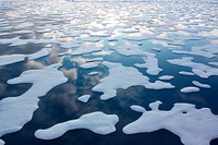
ICESCAPE scientists watched from the deck of the Healy as it cut a path through thick multiyear ice on July 6, 2011.…![The terrain for the scientific work conducted by ICESCAPE scientists on July 4, 2010. Original from NASA. Digitally enhanced…]() The terrain for the scientific work conducted by ICESCAPE scientists on July 4, 2010. Original from NASA. Digitally enhanced…
The terrain for the scientific work conducted by ICESCAPE scientists on July 4, 2010. Original from NASA. Digitally enhanced…![The U.S. Coast Guard Cutter Healy parked in an ice floe for the 2011 ICESCAPE mission's third ice station in the Chukchi…]() The U.S. Coast Guard Cutter Healy parked in an ice floe for the 2011 ICESCAPE mission's third ice station in the Chukchi…
The U.S. Coast Guard Cutter Healy parked in an ice floe for the 2011 ICESCAPE mission's third ice station in the Chukchi…![The ICESCAPE mission, or "Impacts of Climate on Ecosystems and Chemistry of the Arctic Pacific Environment," near Alaska.…]() The ICESCAPE mission, or "Impacts of Climate on Ecosystems and Chemistry of the Arctic Pacific Environment," near Alaska.…
The ICESCAPE mission, or "Impacts of Climate on Ecosystems and Chemistry of the Arctic Pacific Environment," near Alaska.…![Climate change Instagram post template, editable text]() Climate change Instagram post template, editable text
Climate change Instagram post template, editable textTrending Design
![Clark University student Christie Wood lowers a water sampler into a borehole on July 4, 2010. Original from NASA. Digitally…]() Clark University student Christie Wood lowers a water sampler into a borehole on July 4, 2010. Original from NASA. Digitally…
Clark University student Christie Wood lowers a water sampler into a borehole on July 4, 2010. Original from NASA. Digitally…![The U.S. Coast Guard Cutter Healy in the Beaufort Sea, northeast of Barrow, Alaska. Original from NASA . Digitally enhanced…]() The U.S. Coast Guard Cutter Healy in the Beaufort Sea, northeast of Barrow, Alaska. Original from NASA . Digitally enhanced…
The U.S. Coast Guard Cutter Healy in the Beaufort Sea, northeast of Barrow, Alaska. Original from NASA . Digitally enhanced…![NASA scientists are flying over Alaska and Canada, measuring the elevation of rivers and lakes. Original from NASA.…]() NASA scientists are flying over Alaska and Canada, measuring the elevation of rivers and lakes. Original from NASA.…
NASA scientists are flying over Alaska and Canada, measuring the elevation of rivers and lakes. Original from NASA.…![Ice on the Ellsworth Range in Antarctica as seen from the IceBridge DC-8 on Oct. 22, 2012. Original from NASA. Digitally…]() Ice on the Ellsworth Range in Antarctica as seen from the IceBridge DC-8 on Oct. 22, 2012. Original from NASA. Digitally…
Ice on the Ellsworth Range in Antarctica as seen from the IceBridge DC-8 on Oct. 22, 2012. Original from NASA. Digitally…![New NASA laser technology reveals how ice measures up. Original from NASA. Digitally enhanced by rawpixel.]() New NASA laser technology reveals how ice measures up. Original from NASA. Digitally enhanced by rawpixel.
New NASA laser technology reveals how ice measures up. Original from NASA. Digitally enhanced by rawpixel.![An iceberg embedded in sea ice as seen from the IceBridge DC-8 over the Bellingshausen Sea on Oct. 19, 2012. Original from…]() An iceberg embedded in sea ice as seen from the IceBridge DC-8 over the Bellingshausen Sea on Oct. 19, 2012. Original from…
An iceberg embedded in sea ice as seen from the IceBridge DC-8 over the Bellingshausen Sea on Oct. 19, 2012. Original from…![Global warming border, torn paper design]() Global warming border, torn paper design
Global warming border, torn paper design![Global warming border, collage element psd]() Global warming border, collage element psd
Global warming border, collage element psd![Snow is blown off of the Thurston Island calving front off of western Antarctica. Original from NASA. Digitally enhanced by…]() Snow is blown off of the Thurston Island calving front off of western Antarctica. Original from NASA. Digitally enhanced by…
Snow is blown off of the Thurston Island calving front off of western Antarctica. Original from NASA. Digitally enhanced by…![NASA Launches Eighth Year of Antarctic Ice Change Airborne Survey. Original from NASA . Digitally enhanced by rawpixel.]() NASA Launches Eighth Year of Antarctic Ice Change Airborne Survey. Original from NASA . Digitally enhanced by rawpixel.
NASA Launches Eighth Year of Antarctic Ice Change Airborne Survey. Original from NASA . Digitally enhanced by rawpixel.![A NASA scientific balloon awaits launch in McMurdo, Antarctica. Original from NASA. Digitally enhanced by rawpixel.]() A NASA scientific balloon awaits launch in McMurdo, Antarctica. Original from NASA. Digitally enhanced by rawpixel.
A NASA scientific balloon awaits launch in McMurdo, Antarctica. Original from NASA. Digitally enhanced by rawpixel.![Global warming png border, torn paper design, transparent background]() Global warming png border, torn paper design, transparent background
Global warming png border, torn paper design, transparent background![View of the northern Antarctic Peninsula from high altitude during IceBridge's flight back from the Foundation Ice Stream…]() View of the northern Antarctic Peninsula from high altitude during IceBridge's flight back from the Foundation Ice Stream…
View of the northern Antarctic Peninsula from high altitude during IceBridge's flight back from the Foundation Ice Stream…![An iceberg trapped in sea ice in the Amundsen Sea. Original from NASA. Digitally enhanced by rawpixel.]() An iceberg trapped in sea ice in the Amundsen Sea. Original from NASA. Digitally enhanced by rawpixel.
An iceberg trapped in sea ice in the Amundsen Sea. Original from NASA. Digitally enhanced by rawpixel.![Ellesmere Island, which is part of the Qikiqtaaluk Region of the Canadian territory of Nunavut. Original from NASA.…]() Ellesmere Island, which is part of the Qikiqtaaluk Region of the Canadian territory of Nunavut. Original from NASA.…
Ellesmere Island, which is part of the Qikiqtaaluk Region of the Canadian territory of Nunavut. Original from NASA.…![View of the Arctic waters and the far northern lands surrounding it. Original from NASA. Digitally enhanced by rawpixel.]() View of the Arctic waters and the far northern lands surrounding it. Original from NASA. Digitally enhanced by rawpixel.
View of the Arctic waters and the far northern lands surrounding it. Original from NASA. Digitally enhanced by rawpixel.![Environmental awareness sticker, editable design set]() Environmental awareness sticker, editable design set
Environmental awareness sticker, editable design setTrending Design
![Massive Iceberg Breaks Off from Antarctica. Original from NASA. Digitally enhanced by rawpixel.]() Massive Iceberg Breaks Off from Antarctica. Original from NASA. Digitally enhanced by rawpixel.
Massive Iceberg Breaks Off from Antarctica. Original from NASA. Digitally enhanced by rawpixel.![Lake Mackay, the largest of hundreds of ephemeral lakes scattered throughout Western Australia and the Northern Territory.…]() Lake Mackay, the largest of hundreds of ephemeral lakes scattered throughout Western Australia and the Northern Territory.…
Lake Mackay, the largest of hundreds of ephemeral lakes scattered throughout Western Australia and the Northern Territory.…![NASA’s Global Hawk, a remote-controlled airplane, flying above the vicinity of NASA’s Dryden Research Center in…]() NASA’s Global Hawk, a remote-controlled airplane, flying above the vicinity of NASA’s Dryden Research Center in…
NASA’s Global Hawk, a remote-controlled airplane, flying above the vicinity of NASA’s Dryden Research Center in…![The Channel Tunnel, a 50.5 km-long rail tunnel beneath the English Channel at the Straits of Dover. Original from NASA.…]() The Channel Tunnel, a 50.5 km-long rail tunnel beneath the English Channel at the Straits of Dover. Original from NASA.…
The Channel Tunnel, a 50.5 km-long rail tunnel beneath the English Channel at the Straits of Dover. Original from NASA.…![NASA satellite tracks underwater volcanic eruption in Canary Islands. Original from NASA. Digitally enhanced by rawpixel.]() NASA satellite tracks underwater volcanic eruption in Canary Islands. Original from NASA. Digitally enhanced by rawpixel.
NASA satellite tracks underwater volcanic eruption in Canary Islands. Original from NASA. Digitally enhanced by rawpixel.![Grand Turk Island is an island in the Turks and Caicos Islands in the Caribbean, and contains the territory's capital…]() Grand Turk Island is an island in the Turks and Caicos Islands in the Caribbean, and contains the territory's capital…
Grand Turk Island is an island in the Turks and Caicos Islands in the Caribbean, and contains the territory's capital…![Every southern spring and summer, after the Sun has risen into its 24-hour circuit around the skies of Antarctica, the Ross…]() Every southern spring and summer, after the Sun has risen into its 24-hour circuit around the skies of Antarctica, the Ross…
Every southern spring and summer, after the Sun has risen into its 24-hour circuit around the skies of Antarctica, the Ross…![NASA/Goddard Space Flight Center/Reto Stöckli's amazingly beautiful view of Earth from space. October 9th, 2007.…]() NASA/Goddard Space Flight Center/Reto Stöckli's amazingly beautiful view of Earth from space. October 9th, 2007.…
NASA/Goddard Space Flight Center/Reto Stöckli's amazingly beautiful view of Earth from space. October 9th, 2007.…![First view of the entire sunlit side of Earth from one million miles away. Original from NASA. Digitally enhanced by…]() First view of the entire sunlit side of Earth from one million miles away. Original from NASA. Digitally enhanced by…
First view of the entire sunlit side of Earth from one million miles away. Original from NASA. Digitally enhanced by…![Earth Observation taken during the 41G mission on October 5-13, 2016. Original from NASA. Digitally enhanced by rawpixel.]() Earth Observation taken during the 41G mission on October 5-13, 2016. Original from NASA. Digitally enhanced by rawpixel.
Earth Observation taken during the 41G mission on October 5-13, 2016. Original from NASA. Digitally enhanced by rawpixel.![On Feb. 12, 2010, the 21st Winter Olympic Games opened in the city of Vancouver, British Columbia, Canada. NASA's Terra…]() On Feb. 12, 2010, the 21st Winter Olympic Games opened in the city of Vancouver, British Columbia, Canada. NASA's Terra…
On Feb. 12, 2010, the 21st Winter Olympic Games opened in the city of Vancouver, British Columbia, Canada. NASA's Terra…![Mountain tops in Ellesmere Island, Canadian Arctic Archipelago. Original from NASA. Digitally enhanced by rawpixel.]() Mountain tops in Ellesmere Island, Canadian Arctic Archipelago. Original from NASA. Digitally enhanced by rawpixel.
Mountain tops in Ellesmere Island, Canadian Arctic Archipelago. Original from NASA. Digitally enhanced by rawpixel.![Greens and blues of the ocean color from NASA satellite data. Original from NASA. Digitally enhanced by rawpixel.]() Greens and blues of the ocean color from NASA satellite data. Original from NASA. Digitally enhanced by rawpixel.
Greens and blues of the ocean color from NASA satellite data. Original from NASA. Digitally enhanced by rawpixel.![Southern Chile Puyehue volcano came to life on June 4, 2011. Original from NASA. Digitally enhanced by rawpixel.]() Southern Chile Puyehue volcano came to life on June 4, 2011. Original from NASA. Digitally enhanced by rawpixel.
Southern Chile Puyehue volcano came to life on June 4, 2011. Original from NASA. Digitally enhanced by rawpixel.![NASA Blue Marble 2007 West captured by the Moderate Resolution Imaging Spectroradiometer on NASA’s Terra satellite in…]() NASA Blue Marble 2007 West captured by the Moderate Resolution Imaging Spectroradiometer on NASA’s Terra satellite in…
NASA Blue Marble 2007 West captured by the Moderate Resolution Imaging Spectroradiometer on NASA’s Terra satellite in…![Early Melt on the Greenland Ice Sheet . Original from NASA . Digitally enhanced by rawpixel.]() Early Melt on the Greenland Ice Sheet . Original from NASA . Digitally enhanced by rawpixel.
Early Melt on the Greenland Ice Sheet . Original from NASA . Digitally enhanced by rawpixel.![Snake spotted near Launch Pad 39B at NASA's Kennedy Space Center. Original from NASA . Digitally enhanced by rawpixel.]() Snake spotted near Launch Pad 39B at NASA's Kennedy Space Center. Original from NASA . Digitally enhanced by rawpixel.
Snake spotted near Launch Pad 39B at NASA's Kennedy Space Center. Original from NASA . Digitally enhanced by rawpixel.![After school program Instagram post template, editable text]() After school program Instagram post template, editable text
After school program Instagram post template, editable textTrending Design
![A large alligator suns on the bank of a pond within NASA's Kennedy Space Center. Original from NASA. Digitally enhanced by…]() A large alligator suns on the bank of a pond within NASA's Kennedy Space Center. Original from NASA. Digitally enhanced by…
A large alligator suns on the bank of a pond within NASA's Kennedy Space Center. Original from NASA. Digitally enhanced by…![Delhi, the second largest metropolis in India, with a population of 16 million. Original from NASA. Digitally enhanced by…]() Delhi, the second largest metropolis in India, with a population of 16 million. Original from NASA. Digitally enhanced by…
Delhi, the second largest metropolis in India, with a population of 16 million. Original from NASA. Digitally enhanced by…![The city of Sukkur, Pakistan. Original from NASA. Digitally enhanced by rawpixel.]() The city of Sukkur, Pakistan. Original from NASA. Digitally enhanced by rawpixel.
The city of Sukkur, Pakistan. Original from NASA. Digitally enhanced by rawpixel.![The Republic of Singapore, a city-state off the southern tip of the Malay Peninsula. Original from NASA. Digitally enhanced…]() The Republic of Singapore, a city-state off the southern tip of the Malay Peninsula. Original from NASA. Digitally enhanced…
The Republic of Singapore, a city-state off the southern tip of the Malay Peninsula. Original from NASA. Digitally enhanced…![L'Anse aux Meadows is a site on the northernmost tip of the island of Newfoundland. Original from NASA. Digitally enhanced…]() L'Anse aux Meadows is a site on the northernmost tip of the island of Newfoundland. Original from NASA. Digitally enhanced…
L'Anse aux Meadows is a site on the northernmost tip of the island of Newfoundland. Original from NASA. Digitally enhanced…![View of a cloudy earth shown from space. This particular image portrays the average of all of the satellite's cloud…]() View of a cloudy earth shown from space. This particular image portrays the average of all of the satellite's cloud…
View of a cloudy earth shown from space. This particular image portrays the average of all of the satellite's cloud…![The McMurdo Dry Valleys are a row of valleys west of McMurdo Sound, Antarctica. They are so named because of their extremely…]() The McMurdo Dry Valleys are a row of valleys west of McMurdo Sound, Antarctica. They are so named because of their extremely…
The McMurdo Dry Valleys are a row of valleys west of McMurdo Sound, Antarctica. They are so named because of their extremely…![Earth observation by the crew of the International Space Station. Original from NASA. Digitally enhanced by rawpixel.]() Earth observation by the crew of the International Space Station. Original from NASA. Digitally enhanced by rawpixel.
Earth observation by the crew of the International Space Station. Original from NASA. Digitally enhanced by rawpixel.![Arrival of the RRS Ernest Shackleton near Halley Research Station in Antarctica, January, 2013. Original from NASA.…]() Arrival of the RRS Ernest Shackleton near Halley Research Station in Antarctica, January, 2013. Original from NASA.…
Arrival of the RRS Ernest Shackleton near Halley Research Station in Antarctica, January, 2013. Original from NASA.…![An alligator achieves partial camouflage from green algae. Original from NASA. Digitally enhanced by rawpixel.]() An alligator achieves partial camouflage from green algae. Original from NASA. Digitally enhanced by rawpixel.
An alligator achieves partial camouflage from green algae. Original from NASA. Digitally enhanced by rawpixel.![At NASA's Kennedy Space Center in Florida, a dragonfly is seen in the Launch Complex 39 area near the Press Site. Original…]() At NASA's Kennedy Space Center in Florida, a dragonfly is seen in the Launch Complex 39 area near the Press Site. Original…
At NASA's Kennedy Space Center in Florida, a dragonfly is seen in the Launch Complex 39 area near the Press Site. Original…![A flock of white pelicans cruise through the blue sky over NASA's Kennedy Space Center. Original from NASA . Digitally…]() A flock of white pelicans cruise through the blue sky over NASA's Kennedy Space Center. Original from NASA . Digitally…
A flock of white pelicans cruise through the blue sky over NASA's Kennedy Space Center. Original from NASA . Digitally…![The Arctic Circle cuts through the western coast of Norway and the Saltfjellet-Svartisen National Park. Original from NASA.…]() The Arctic Circle cuts through the western coast of Norway and the Saltfjellet-Svartisen National Park. Original from NASA.…
The Arctic Circle cuts through the western coast of Norway and the Saltfjellet-Svartisen National Park. Original from NASA.…![Longyearbyen, the largest island of the Svalbard archipelago, part of the Kingdom of Norway. Original from NASA. Digitally…]() Longyearbyen, the largest island of the Svalbard archipelago, part of the Kingdom of Norway. Original from NASA. Digitally…
Longyearbyen, the largest island of the Svalbard archipelago, part of the Kingdom of Norway. Original from NASA. Digitally…![The Kondyor Massif is located in Eastern Siberia, Russia, north of the city of Khabarovsk. Original from NASA. Digitally…]() The Kondyor Massif is located in Eastern Siberia, Russia, north of the city of Khabarovsk. Original from NASA. Digitally…
The Kondyor Massif is located in Eastern Siberia, Russia, north of the city of Khabarovsk. Original from NASA. Digitally…![NASA’s Operation IceBridge Completes Twin Polar Campaigns. Heimdal Glacier in southern Greenland. Original from NASA.…]() NASA’s Operation IceBridge Completes Twin Polar Campaigns. Heimdal Glacier in southern Greenland. Original from NASA.…
NASA’s Operation IceBridge Completes Twin Polar Campaigns. Heimdal Glacier in southern Greenland. Original from NASA.…![A gopher tortoise searches for food at the edge of a road near Launch Pad 39A. Original from NASA . Digitally enhanced by…]() A gopher tortoise searches for food at the edge of a road near Launch Pad 39A. Original from NASA . Digitally enhanced by…
A gopher tortoise searches for food at the edge of a road near Launch Pad 39A. Original from NASA . Digitally enhanced by…![Skylab 3 Earth view of Washington, British Columbia, Vancouver Island and Puget Sound. July-September, 1973. Original from…]() Skylab 3 Earth view of Washington, British Columbia, Vancouver Island and Puget Sound. July-September, 1973. Original from…
Skylab 3 Earth view of Washington, British Columbia, Vancouver Island and Puget Sound. July-September, 1973. Original from…![The world largest bauxite mine found near Weipa, Queensland, Australia. Original from NASA. Digitally enhanced by rawpixel.]() The world largest bauxite mine found near Weipa, Queensland, Australia. Original from NASA. Digitally enhanced by rawpixel.
The world largest bauxite mine found near Weipa, Queensland, Australia. Original from NASA. Digitally enhanced by rawpixel.![New image of the Earth at night is a composite assembled from data acquired by the Suomi National Polar-orbiting Partnership…]() New image of the Earth at night is a composite assembled from data acquired by the Suomi National Polar-orbiting Partnership…
New image of the Earth at night is a composite assembled from data acquired by the Suomi National Polar-orbiting Partnership…![Images of the Earth's land surface and surrounding coastal regions. Original from NASA. Digitally enhanced by rawpixel.]() Images of the Earth's land surface and surrounding coastal regions. Original from NASA. Digitally enhanced by rawpixel.
Images of the Earth's land surface and surrounding coastal regions. Original from NASA. Digitally enhanced by rawpixel.![The northernmost land in the world is located in Pearyland, Greenland. Original from NASA. Digitally enhanced by rawpixel.]() The northernmost land in the world is located in Pearyland, Greenland. Original from NASA. Digitally enhanced by rawpixel.
The northernmost land in the world is located in Pearyland, Greenland. Original from NASA. Digitally enhanced by rawpixel.![Image taken by a new Earth-observing instrument installed on the international space station. Original from NASA. Digitally…]() Image taken by a new Earth-observing instrument installed on the international space station. Original from NASA. Digitally…
Image taken by a new Earth-observing instrument installed on the international space station. Original from NASA. Digitally…![A dolphin's dorsal fin cuts through the water in the Launch Complex 39 Area turn basin at NASA's Kennedy Space Center.…]() A dolphin's dorsal fin cuts through the water in the Launch Complex 39 Area turn basin at NASA's Kennedy Space Center.…
A dolphin's dorsal fin cuts through the water in the Launch Complex 39 Area turn basin at NASA's Kennedy Space Center.…![Typhoon Phanfone affecting Japan, on October 5, 2014. Original from NASA. Digitally enhanced by rawpixel.]() Typhoon Phanfone affecting Japan, on October 5, 2014. Original from NASA. Digitally enhanced by rawpixel.
Typhoon Phanfone affecting Japan, on October 5, 2014. Original from NASA. Digitally enhanced by rawpixel.![A female bald eagle looks over her surroundings from the perspective of a tall pine tree. Original from NASA . Digitally…]() A female bald eagle looks over her surroundings from the perspective of a tall pine tree. Original from NASA . Digitally…
A female bald eagle looks over her surroundings from the perspective of a tall pine tree. Original from NASA . Digitally…![A great white egret casts a reflection in placid water just north of the Shuttle Landing Facility at NASA's Kennedy Space…]() A great white egret casts a reflection in placid water just north of the Shuttle Landing Facility at NASA's Kennedy Space…
A great white egret casts a reflection in placid water just north of the Shuttle Landing Facility at NASA's Kennedy Space…![A yellow rat snake slithers through the grass. Original from NASA. Digitally enhanced by rawpixel.]() A yellow rat snake slithers through the grass. Original from NASA. Digitally enhanced by rawpixel.
A yellow rat snake slithers through the grass. Original from NASA. Digitally enhanced by rawpixel.![An American bald eagle soars through the air. Original from NASA. Digitally enhanced by rawpixel.]() An American bald eagle soars through the air. Original from NASA. Digitally enhanced by rawpixel.
An American bald eagle soars through the air. Original from NASA. Digitally enhanced by rawpixel.![India and Ceylon as seen from the orbiting Gemini-11 spacecraft. Original from NASA. Digitally enhanced by rawpixel.]() India and Ceylon as seen from the orbiting Gemini-11 spacecraft. Original from NASA. Digitally enhanced by rawpixel.
India and Ceylon as seen from the orbiting Gemini-11 spacecraft. Original from NASA. Digitally enhanced by rawpixel.![View of Island of Kyushu, Japan from Skylab. Original from NASA. Digitally enhanced by rawpixel.]() View of Island of Kyushu, Japan from Skylab. Original from NASA. Digitally enhanced by rawpixel.
View of Island of Kyushu, Japan from Skylab. Original from NASA. Digitally enhanced by rawpixel.![Nearly cloud-free view of Great Britain and Ireland was acquired by the Moderate Resolution Imaging Spectroradiometer aboard…]() Nearly cloud-free view of Great Britain and Ireland was acquired by the Moderate Resolution Imaging Spectroradiometer aboard…
Nearly cloud-free view of Great Britain and Ireland was acquired by the Moderate Resolution Imaging Spectroradiometer aboard…![Lake Ilopango, a crater lake which fills a volcanic caldera in central El Salvador. Original from NASA. Digitally enhanced…]() Lake Ilopango, a crater lake which fills a volcanic caldera in central El Salvador. Original from NASA. Digitally enhanced…
Lake Ilopango, a crater lake which fills a volcanic caldera in central El Salvador. Original from NASA. Digitally enhanced…![Sheveluch Volcano in Kamchatka, Siberia. Original from NASA. Digitally enhanced by rawpixel.]() Sheveluch Volcano in Kamchatka, Siberia. Original from NASA. Digitally enhanced by rawpixel.
Sheveluch Volcano in Kamchatka, Siberia. Original from NASA. Digitally enhanced by rawpixel.![Attu, the westernmost Aleutian island, is nearly 1760 km from the Alaskan mainland. Original from NASA. Digitally enhanced…]() Attu, the westernmost Aleutian island, is nearly 1760 km from the Alaskan mainland. Original from NASA. Digitally enhanced…
Attu, the westernmost Aleutian island, is nearly 1760 km from the Alaskan mainland. Original from NASA. Digitally enhanced…![A black-necked stilt searches the shallow water for food at NASA's Kennedy Space Center in Florida. Original from NASA.…]() A black-necked stilt searches the shallow water for food at NASA's Kennedy Space Center in Florida. Original from NASA.…
A black-necked stilt searches the shallow water for food at NASA's Kennedy Space Center in Florida. Original from NASA.…![Impact of Northern California fires seen in new NASA satellite image. Original from NASA. Digitally enhanced by rawpixel.]() Impact of Northern California fires seen in new NASA satellite image. Original from NASA. Digitally enhanced by rawpixel.
Impact of Northern California fires seen in new NASA satellite image. Original from NASA. Digitally enhanced by rawpixel.![Cloud vortices off Madeira and Canary Islands. Original from NASA. Digitally enhanced by rawpixel.]() Cloud vortices off Madeira and Canary Islands. Original from NASA. Digitally enhanced by rawpixel.
Cloud vortices off Madeira and Canary Islands. Original from NASA. Digitally enhanced by rawpixel.![NASA GOES 12 satellite image showing earth on March 30, 2010. Original from NASA. Digitally enhanced by rawpixel.]() NASA GOES 12 satellite image showing earth on March 30, 2010. Original from NASA. Digitally enhanced by rawpixel.
NASA GOES 12 satellite image showing earth on March 30, 2010. Original from NASA. Digitally enhanced by rawpixel.![GOES 12 satellite image showing earth on March 25, 2010. Original from NASA . Digitally enhanced by rawpixel.]() GOES 12 satellite image showing earth on March 25, 2010. Original from NASA . Digitally enhanced by rawpixel.
GOES 12 satellite image showing earth on March 25, 2010. Original from NASA . Digitally enhanced by rawpixel.![Fog blankets the woods near a road in the Merritt Island National Wildlife Refuge at NASA's Kennedy Space Center in Florida.…]() Fog blankets the woods near a road in the Merritt Island National Wildlife Refuge at NASA's Kennedy Space Center in Florida.…
Fog blankets the woods near a road in the Merritt Island National Wildlife Refuge at NASA's Kennedy Space Center in Florida.…![Rare clear view of Alaska. Original from NASA. Digitally enhanced by rawpixel.]() Rare clear view of Alaska. Original from NASA. Digitally enhanced by rawpixel.
Rare clear view of Alaska. Original from NASA. Digitally enhanced by rawpixel.![Images of the Earth's land surface and surrounding coastal regions. Original from NASA. Digitally enhanced by rawpixel.]() Images of the Earth's land surface and surrounding coastal regions. Original from NASA. Digitally enhanced by rawpixel.
Images of the Earth's land surface and surrounding coastal regions. Original from NASA. Digitally enhanced by rawpixel.![The central coastal area of Peru as seen from the Gemini-9A spacecraft. Original from NASA. Digitally enhanced by rawpixel]() The central coastal area of Peru as seen from the Gemini-9A spacecraft. Original from NASA. Digitally enhanced by rawpixel
The central coastal area of Peru as seen from the Gemini-9A spacecraft. Original from NASA. Digitally enhanced by rawpixel![Full Mir over New Zealand, from the space shuttle Atlantis, Russia's Mir Space Station. Original from NASA. Digitally…]() Full Mir over New Zealand, from the space shuttle Atlantis, Russia's Mir Space Station. Original from NASA. Digitally…
Full Mir over New Zealand, from the space shuttle Atlantis, Russia's Mir Space Station. Original from NASA. Digitally…![MODIS on the Aqua satellite captured this stunning view of Japans four largest islands on February 20, 2004. Original from…]() MODIS on the Aqua satellite captured this stunning view of Japans four largest islands on February 20, 2004. Original from…
MODIS on the Aqua satellite captured this stunning view of Japans four largest islands on February 20, 2004. Original from…![Island of Hawaii, State of Hawaii seen from Skylab. Original from NASA. Digitally enhanced by rawpixel.]() Island of Hawaii, State of Hawaii seen from Skylab. Original from NASA. Digitally enhanced by rawpixel.
Island of Hawaii, State of Hawaii seen from Skylab. Original from NASA. Digitally enhanced by rawpixel.