Satellite-based view of the Arctic. The images for this scene were captured on September 2, 2012, by the Visible Infrared… https://www.rawpixel.com/image/8717957/photo-image-clouds-space-planet Free Image from public domain license
Clear shot of every parcel of Earth’s land surface and islands in nighttime view in visible light. A composite of… https://www.rawpixel.com/image/440239/earth-night Free Image from public domain license
NASA-NOAA's Suomi NPP Satellite Gets Colorful Look at Hurricane Blanca. Original from NASA. Digitally enhanced by rawpixel. https://www.rawpixel.com/image/440152/free-photo-image-hurricane-nasa-storm Free Image from public domain license
Amazing image of the United States of America at night. Original from NASA. Digitally enhanced by rawpixel. https://www.rawpixel.com/image/418600/united-states-america-night Free Image from public domain license
Composite assembled from data acquired by the Suomi National Polar-orbiting Partnership satellite over nine days in April… https://www.rawpixel.com/image/440178/map-lights-night-from-nasa Free Image from public domain license
Amazing image of the United States of America at night. Original from NASA. Digitally enhanced by rawpixel. https://www.rawpixel.com/image/418612/the-united-states-america-night Free Image from public domain license
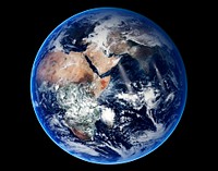
Amazing image of the Earth. Original from NASA. Digitally enhanced by rawpixel. https://www.rawpixel.com/image/418640/free-photo-image-planet-nasa-marble Free Image from public domain license
Silk screen collage element, editable design set https://www.rawpixel.com/image/14328479/silk-screen-collage-element-editable-design-set View license Trending Design
The Rio Tinto river in southwestern Spain. Original from NASA. Digitally enhanced by rawpixel. https://www.rawpixel.com/image/441261/free-photo-image-spain-rio-tinto-satellite-climate-change Free Image from public domain license
The magnificent natural landscape of Salzkammergut, Austria. Original from NASA . Digitally enhanced by rawpixel. https://www.rawpixel.com/image/441272/free-photo-image-topography-austria-earthquake Free Image from public domain license
San Francisco and Bay Area, CA, USA. Original from NASA. Digitally enhanced by rawpixel. https://www.rawpixel.com/image/441579/free-photo-image-nasa-map-aerial Free Image from public domain license
The Wilkins Ice Shelf on the western side of the Antarctic Peninsula. Original from NASA. Digitally enhanced by rawpixel. https://www.rawpixel.com/image/441236/free-photo-image-maps-snow-advanced-spaceborne-thermal-emission-and-reflection-radiometer-aster Free Image from public domain license
View of Minneapolis-St.Paul, Minnesota area. Original from NASA. Digitally enhanced by rawpixel. https://www.rawpixel.com/image/441781/free-photo-image-nasa-minnesota-topography Free Image from public domain license
Global Digital Elevation Model. Original from NASA. Digitally enhanced by rawpixel. https://www.rawpixel.com/image/441216/free-photo-image-atlas-thermal-imaging-globe Free Image from public domain license
Image formed by the Advanced Spaceborne Thermal Emission and Reflection Radiometer (ASTER) and Global Digital Elevation… https://www.rawpixel.com/image/441205/free-photo-image-world-map-digital Free Image from public domain license
Earth with grunge texture https://www.rawpixel.com/image/12633376/earth-with-grunge-texture View license
Image of a nebula taken using a NASA telescope - Original from NASA. Digitally enhanced by rawpixel. https://www.rawpixel.com/image/440557/free-photo-image-galaxy-nebula-orion Free Image from public domain license
A forest fire burning in Volusia County, Florida. Original from NASA. Digitally enhanced by rawpixel. https://www.rawpixel.com/image/441471/free-photo-image-forest-fire-burning Free Image from public domain license
The STS-93 astronauts aboard the Space Shuttle Columbia took this picture over the Indian Ocean on 23-27 July 1999. Original… https://www.rawpixel.com/image/441586/free-photo-image-water-madagascar-indian Free Image from public domain license
Central area of Ethiopia, south of Addis Ababa, showing Lakes Zwai, Langana, and Shala. Original from NASA. Digitally… https://www.rawpixel.com/image/441749/free-photo-image-ethiopia-maps-addis-ababa Free Image from public domain license
Hurricane Gonzalo's northern quadrant over Bermuda. Original from NASA. Digitally enhanced by rawpixel. https://www.rawpixel.com/image/440115/free-photo-image-hurricane-nasa-climate-change Free Image from public domain license
Isles of Scilly, United Kingdom. Original from NASA. Digitally enhanced by rawpixel. https://www.rawpixel.com/image/440822/free-photo-image-island-map-nasa Free Image from public domain license
Northern half of Mauritania's Atlantic Coast from Skylab. Original from NASA. Digitally enhanced by rawpixel. https://www.rawpixel.com/image/441592/free-photo-image-ocean-sand-aerial-view Free Image from public domain license
Arabian Peninsula and northeast Africa as seen from the orbiting Gemini-11. Original from NASA. Digitally enhanced by… https://www.rawpixel.com/image/441740/free-photo-image-africa-map-space-view Free Image from public domain license
View of portion of Queensland, Australia from Skylab space station. Original from NASA. Digitally enhanced by rawpixel https://www.rawpixel.com/image/441793/free-photo-image-australia-map-skylab Free Image from public domain license
Satellite Shows an "Arctic Blanket" Over the U.S. Original from NASA. Digitally enhanced by rawpixel. https://www.rawpixel.com/image/440086/free-photo-image-earth-planet-space Free Image from public domain license
After school program Instagram post template, editable text https://www.rawpixel.com/image/12739103/after-school-program-instagram-post-template-editable-text View license Trending Design
Dendi Caldera, Ethiopia is featured in this image photographed by an Expedition 16 crew member on the International Space… https://www.rawpixel.com/image/440818/free-photo-image-ethiopia-nasa-satellite Free Image from public domain license
Savannah River Site, South Carolina. Original from NASA. Digitally enhanced by rawpixel. https://www.rawpixel.com/image/440794/free-photo-image-atlantic-science-world-map Free Image from public domain license
Earth observation by the crew of the International Space Station. Original from NASA. Digitally enhanced by rawpixel. https://www.rawpixel.com/image/440323/free-photo-image-new-zealand-maps-island Free Image from public domain license
A plume at Shiveluch Volcano, Kamchatka Peninsula, Russia. Original from NASA. Digitally enhanced by rawpixel. https://www.rawpixel.com/image/440825/free-photo-image-volcano-maps-plume Free Image from public domain license
Skylab 3 Earth view of the Grand Canyon, Lake Mead and Kaibab. Original from NASA. Digitally enhanced by rawpixel. https://www.rawpixel.com/image/439887/free-photo-image-nasa-nasa-earth-maps Free Image from public domain license
Simulated natural color image of Huron, South Dakota, captured by NASA's Terra spacecraft. Original from NASA. Digitally… https://www.rawpixel.com/image/441231/free-photo-image-south-dakota-satellite-aerial Free Image from public domain license
On August 22, 2014 the Moderate Resolution Imaging Spectroradiometer aboard NASA’s Terra satellite captured a true… https://www.rawpixel.com/image/440172/free-photo-image-nasa-iceland-satellite Free Image from public domain license
Missionary Plains in Australia’s Northern Territory, a crater 24 kilometers in diameter and 5 kilometers deep.… https://www.rawpixel.com/image/440278/free-photo-image-nasa-australia-landscape Free Image from public domain license
The Lena River, some 2,800 miles long, is one of the largest rivers in the world. Original from NASA. Digitally enhanced by… https://www.rawpixel.com/image/440230/free-photo-image-nasa-russia-earth Free Image from public domain license
View of the USSR, Siberia area from Skylab 4. Other areas seen are Ozero, Kanka, Ussiriysk, the Sea of Japan and Kavalerovo.… https://www.rawpixel.com/image/441773/free-photo-image-siberia-japan-maps Free Image from public domain license
Skylab 3 Earth view of the Nile Delta, Egypt and Suez Canal. Original from NASA. Digitally enhanced by rawpixel. https://www.rawpixel.com/image/439888/free-photo-image-egypt-map-nasa-ocean Free Image from public domain license
This image from NASA's Terra spacecraft shows Beihai, a city in the south of Guangxi, People's republic of China. Original… https://www.rawpixel.com/image/440652/free-photo-image-map-nasa-china Free Image from public domain license
The meandering Ohio River bisecting this image is the border between Kentucky and Indiana. Original from NASA. Digitally… https://www.rawpixel.com/image/441771/free-photo-image-city-map-border-maps Free Image from public domain license
Images of the Earth's land surface and surrounding coastal regions. Original from NASA. Digitally enhanced by rawpixel. https://www.rawpixel.com/image/440126/free-photo-image-map-coastal-nasa Free Image from public domain license
Nuuk (or Gadthab) is the capital and largest city of Greenland. Original from NASA. Digitally enhanced by rawpixel https://www.rawpixel.com/image/441177/free-photo-image-space-earth-aerial-view Free Image from public domain license
Parts of the vast Ganges delta, in fact the world's largest, lie in both Bangladesh and the State of West Bengal, India.… https://www.rawpixel.com/image/441155/free-photo-image-india-map-nasa Free Image from public domain license
Al Jazirah (also Gezira) is one of the 26 states of Sudan. Original from NASA. Digitally enhanced by rawpixel. https://www.rawpixel.com/image/441167/free-photo-image-map-nasa-blue Free Image from public domain license
Little Bahama Bank, the most northerly of the island groups that comprise the Bahamas. Original from NASA. Digitally… https://www.rawpixel.com/image/441175/free-photo-image-bahamas-maps-aerial Free Image from public domain license
Rare clear view of Alaska. Original from NASA. Digitally enhanced by rawpixel. https://www.rawpixel.com/image/440179/free-photo-image-coastline-forest-maps Free Image from public domain license
Silk screen collage element, editable design set https://www.rawpixel.com/image/14328330/silk-screen-collage-element-editable-design-set View license Trending Design
NASA's Wallops Flight Facility is located on Wallops Island. Satellite imagery from NOAA's GOES-East satellite shows that… https://www.rawpixel.com/image/440110/free-photo-image-nasa-satellite-maps Free Image from public domain license
The Arctic Circle cuts through the western coast of Norway and the Saltfjellet-Svartisen National Park. Original from NASA.… https://www.rawpixel.com/image/441172/free-photo-image-nasa-climate-change-aerial Free Image from public domain license
Longyearbyen, the largest island of the Svalbard archipelago, part of the Kingdom of Norway. Original from NASA. Digitally… https://www.rawpixel.com/image/439954/free-photo-image-nasa-norway-mountains-world-map Free Image from public domain license
Greens and blues of the ocean color from NASA satellite data. Original from NASA. Digitally enhanced by rawpixel. https://www.rawpixel.com/image/440118/free-photo-image-maps-plankton-dance Free Image from public domain license
The Kondyor Massif is located in Eastern Siberia, Russia, north of the city of Khabarovsk. Original from NASA. Digitally… https://www.rawpixel.com/image/441148/free-photo-image-map-nasa-russia Free Image from public domain license
NASA Satellite Captures Super Bowl Cities - Santa Clara, CA .Original from NASA. Digitally enhanced by rawpixel. https://www.rawpixel.com/image/440093/free-photo-image-california-map-maps-city-satellite Free Image from public domain license
This image from NASA's Terra spacecraft shows the Kuk Early Agricultural Site in the western highlands of New Guinea.… https://www.rawpixel.com/image/441178/free-photo-image-swamp-nasa-climate-change Free Image from public domain license
Lake Naivasha, 90km north-west of Nairobi. Original from NASA. Digitally enhanced by rawpixel. https://www.rawpixel.com/image/441152/free-photo-image-kenya-nasa-lake-satellite-landscape Free Image from public domain license
The Uvs Nuur Basin in Mongolia and the Russian Federation. Original from NASA. Digitally enhanced by rawpixel. https://www.rawpixel.com/image/439971/free-photo-image-nasa-maps-earth-observations Free Image from public domain license
Rio Gurupi in the Brazilian state of Maranhao and its delta.Original from NASA. Digitally enhanced by rawpixel. https://www.rawpixel.com/image/441149/free-photo-image-maps-delta-space-earth Free Image from public domain license
Nadir view of the southern Cape District of South Africa. Original from NASA. Digitally enhanced by rawpixel. https://www.rawpixel.com/image/441620/free-photo-image-africa-south-cape-town Free Image from public domain license
Eruption of Cleveland Volcano, Aleutian Islands, Alaska. Original from NASA. Digitally enhanced by rawpixel. https://www.rawpixel.com/image/440821/free-photo-image-volcano-maps-nasa Free Image from public domain license
View of a cloudy earth shown from space. This particular image portrays the average of all of the satellite's cloud… https://www.rawpixel.com/image/440144/cloudy-earth Free Image from public domain license
This rare cloud-free view of southern Italy shows almost all of the famous `boot' configuration of the peninsula up to just… https://www.rawpixel.com/image/441789/free-photo-image-southern-italy-nasa-skylab Free Image from public domain license
Iran, Trucial Coast, Oman, Zagros Mountains, and Qishm Island (large island at lower left), as seen from the Gemini-12… https://www.rawpixel.com/image/441767/free-photo-image-nasa-map-iran Free Image from public domain license
NASA image acquired August 17, 2010, the Northwest Passage almost free of ice. Original from NASA. Digitally enhanced by… https://www.rawpixel.com/image/440249/free-photo-image-passage-global-warming-nasa Free Image from public domain license
Lying in the eastern Mediterranean Sea, the entire Island of Crete (35.0N, 25.0E) can be seen in great detail in this cloud… https://www.rawpixel.com/image/441790/free-photo-image-crete-greece-mediterranean Free Image from public domain license
View of the southeastern tip of the Arabian Peninsula with the Gulf of Oman at upper right. Original from NASA . Digitally… https://www.rawpixel.com/image/441702/free-photo-image-nasa-satellite-arabian Free Image from public domain license
The Isthmus of Corinth has played a very important role in the history of Greece. Original from NASA. Digitally enhanced by… https://www.rawpixel.com/image/441129/free-photo-image-nasa-greece-maps Free Image from public domain license
This image from NASA's EarthKAM shows Lisbon, the capital of Portugal. Original from NASA. Digitally enhanced by rawpixel. https://www.rawpixel.com/image/441176/free-photo-image-map-satellite-maps-public-domain-portugal Free Image from public domain license
Environmental awareness sticker, editable design set https://www.rawpixel.com/image/14132564/environmental-awareness-sticker-editable-design-set View license Trending Design
This image from NASA's EarthKAM captures almost all of Quinghai, the largest lake in China. Original from NASA. Digitally… https://www.rawpixel.com/image/441166/free-photo-image-china-map-space Free Image from public domain license
Image showing the west coast of Greenland, one of Earth's premiere incubators for icebergs. Original from NASA. Digitally… https://www.rawpixel.com/image/441795/free-photo-image-aerial-view-maps Free Image from public domain license
Baja California, Colorado river and Sonora Desert. Original from NASA. Digitally enhanced by rawpixel. https://www.rawpixel.com/image/441734/free-photo-image-nasa-water-river Free Image from public domain license
Lake Ilopango, a crater lake which fills a volcanic caldera in central El Salvador. Original from NASA. Digitally enhanced… https://www.rawpixel.com/image/440647/free-photo-image-salvador-satellite-lake Free Image from public domain license
This image of the Galapagos Islands captures two large shield volcanoes on Isla Isabella. Original from NASA. Digitally… https://www.rawpixel.com/image/441165/free-photo-image-maps-ecuador-galapagos-islands Free Image from public domain license
Apollo 9 Mission image - S0-65 Multispectral Photography - New Mexico. Original from NASA. Digitally enhanced by rawpixel. https://www.rawpixel.com/image/440775/free-photo-image-lava-mexico-maps Free Image from public domain license
View of the heart of Shenandoah National Park on October 10, 2010, at the height of the fall “leaf-peeping”… https://www.rawpixel.com/image/440112/free-photo-image-climate-change-seasons-national-park Free Image from public domain license
Sheveluch Volcano in Kamchatka, Siberia. Original from NASA. Digitally enhanced by rawpixel. https://www.rawpixel.com/image/441226/free-photo-image-map-volcano-nasa Free Image from public domain license
Teshekpuk Lake on Alaska's North Slope, within the National Petroleum Reserve. Original from NASA. Digitally enhanced by… https://www.rawpixel.com/image/441144/free-photo-image-science-alaska-world-map Free Image from public domain license
Attu, the westernmost Aleutian island, is nearly 1760 km from the Alaskan mainland. Original from NASA. Digitally enhanced… https://www.rawpixel.com/image/441125/free-photo-image-nasa-map-space-earth Free Image from public domain license
Aerial view of Berlin, acquired by NASA's Terra spacecraft. Original from NASA. Digitally enhanced by rawpixel. https://www.rawpixel.com/image/441098/free-photo-image-maps-berlin-nasa-stadium Free Image from public domain license
Phytoplankton bloom in the Bay of Biscay. Original from NASA. Digitally enhanced by rawpixel. https://www.rawpixel.com/image/440161/free-photo-image-map-satellite-nasa Free Image from public domain license
Rostov-on-Don, a Russian City on the Don River, 32 kilometers from the Sea of Azov. Original from NASA. Digitally enhanced… https://www.rawpixel.com/image/440623/free-photo-image-nasa-map-world Free Image from public domain license
Cornell University, Infrared Interferometer mission directors console. Original from NASA. Digitally enhanced by rawpixel. https://www.rawpixel.com/image/440063/free-photo-image-nasa-room-technology Free Image from public domain license
Calcite Quarry, Michigan. Original from NASA. Digitally enhanced by rawpixel. https://www.rawpixel.com/image/440781/free-photo-image-maps-earth-aerial-north Free Image from public domain license
Parts of Galveston and Harris Counties and Galveston Bay and several communities in the Clear Lake area. Original from NASA.… https://www.rawpixel.com/image/440837/free-photo-image-map-usa-galveston Free Image from public domain license
NASA and NOAA satellites are studying the triple tropical tempests that are now romping through the Eastern Pacific Ocean.… https://www.rawpixel.com/image/440125/free-photo-image-earth-planet-world-pacific-ocean Free Image from public domain license
Snow covered Alps of France, Italy, and Switzerland. Original from NASA. Digitally enhanced by rawpixel. https://www.rawpixel.com/image/441581/free-photo-image-nasa-switzerland-aerial Free Image from public domain license
Cornell University, FAR Infrared Interferometer mission directors console. Original from NASA. Digitally enhanced by… https://www.rawpixel.com/image/440077/free-photo-image-nasa-research-cockpit Free Image from public domain license
Snow, which tends to be generally less bright that clouds, covers the Alps in the north of Italy. Original from NASA.… https://www.rawpixel.com/image/440140/free-photo-image-italy-map-maps Free Image from public domain license
Nearly cloud-free view of Great Britain and Ireland was acquired by the Moderate Resolution Imaging Spectroradiometer aboard… https://www.rawpixel.com/image/440141/great-britain-space-view Free Image from public domain license
This is an 800mm oblique view which covers an area including Moffett Federal Air Field, NASA's Ames Research Center… https://www.rawpixel.com/image/439978/free-photo-image-maps-california-map-landscape-aerial Free Image from public domain license
Moffett Federal Air Field, NASA Ames Research Center and Silicon Valley. Original from NASA. Digitally enhanced by rawpixel. https://www.rawpixel.com/image/441405/free-photo-image-maps-nasa-california-map Free Image from public domain license
Sediment Spews from Connecticut River. Original from NASA. Digitally enhanced by rawpixel. https://www.rawpixel.com/image/440189/free-photo-image-massachusetts-nasa-long-island Free Image from public domain license
Cosiguina Volcano, Nicaragua. Original from NASA. Digitally enhanced by rawpixel. https://www.rawpixel.com/image/440815/free-photo-image-nicaragua-pacific-ocean-map-nasa Free Image from public domain license
Beautiful new mosaic of Chesapeake Bay. Original from NASA. Digitally enhanced by rawpixel. https://www.rawpixel.com/image/440207/free-photo-image-maps-aerial-satellite-view Free Image from public domain license
Torrential rains in the mid-South of the United States in mid-March 2016 produced flooding throughout Texas, Louisiana and… https://www.rawpixel.com/image/440664/free-photo-image-nasa-louisiana-space Free Image from public domain license
Typhoon Phanfone affecting Japan, on October 5, 2014. Original from NASA. Digitally enhanced by rawpixel. https://www.rawpixel.com/image/440100/free-photo-image-typhoon-nasa-japan Free Image from public domain license
The John F. Kennedy Space Center, America's spaceport, is located along Florida's eastern shore on Cape Canaveral. Original… https://www.rawpixel.com/image/441135/free-photo-image-florida-florida-maps-public-domain-map Free Image from public domain license