![Baja California, Colorado river and Sonora Desert. Original from NASA. Digitally enhanced by rawpixel.]() Baja California, Colorado river and Sonora Desert. Original from NASA. Digitally enhanced by rawpixel.
Baja California, Colorado river and Sonora Desert. Original from NASA. Digitally enhanced by rawpixel.![Massive congregations of greenish phytoplankton swirl in the dark water around Gotland, a Swedish island in the Baltic Sea.…]() Massive congregations of greenish phytoplankton swirl in the dark water around Gotland, a Swedish island in the Baltic Sea.…
Massive congregations of greenish phytoplankton swirl in the dark water around Gotland, a Swedish island in the Baltic Sea.…![Hurricane Gonzalo's northern quadrant over Bermuda. Original from NASA. Digitally enhanced by rawpixel.]() Hurricane Gonzalo's northern quadrant over Bermuda. Original from NASA. Digitally enhanced by rawpixel.
Hurricane Gonzalo's northern quadrant over Bermuda. Original from NASA. Digitally enhanced by rawpixel.![Aaland archipelago at the mouth of the Gulf of Bothnia which belongs to Finland. Original from NASA. Digitally enhanced by…]() Aaland archipelago at the mouth of the Gulf of Bothnia which belongs to Finland. Original from NASA. Digitally enhanced by…
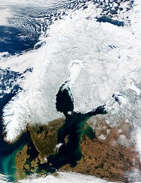
Aaland archipelago at the mouth of the Gulf of Bothnia which belongs to Finland. Original from NASA. Digitally enhanced by…![Missionary Plains in Australia’s Northern Territory, a crater 24 kilometers in diameter and 5 kilometers deep.…]() Missionary Plains in Australia’s Northern Territory, a crater 24 kilometers in diameter and 5 kilometers deep.…
Missionary Plains in Australia’s Northern Territory, a crater 24 kilometers in diameter and 5 kilometers deep.…![NASA and NOAA satellites are studying the triple tropical tempests that are now romping through the Eastern Pacific Ocean.…]() NASA and NOAA satellites are studying the triple tropical tempests that are now romping through the Eastern Pacific Ocean.…
NASA and NOAA satellites are studying the triple tropical tempests that are now romping through the Eastern Pacific Ocean.…![NASA Blue Marble 2007 West captured by the Moderate Resolution Imaging Spectroradiometer on NASA’s Terra satellite in…]() NASA Blue Marble 2007 West captured by the Moderate Resolution Imaging Spectroradiometer on NASA’s Terra satellite in…
NASA Blue Marble 2007 West captured by the Moderate Resolution Imaging Spectroradiometer on NASA’s Terra satellite in…![Rare clear view of Alaska. Original from NASA. Digitally enhanced by rawpixel.]() Rare clear view of Alaska. Original from NASA. Digitally enhanced by rawpixel.
Rare clear view of Alaska. Original from NASA. Digitally enhanced by rawpixel.![Images of the Earth's land surface and surrounding coastal regions. Original from NASA. Digitally enhanced by rawpixel.]() Images of the Earth's land surface and surrounding coastal regions. Original from NASA. Digitally enhanced by rawpixel.
Images of the Earth's land surface and surrounding coastal regions. Original from NASA. Digitally enhanced by rawpixel.![Every southern spring and summer, after the Sun has risen into its 24-hour circuit around the skies of Antarctica, the Ross…]() Every southern spring and summer, after the Sun has risen into its 24-hour circuit around the skies of Antarctica, the Ross…
Every southern spring and summer, after the Sun has risen into its 24-hour circuit around the skies of Antarctica, the Ross…![Phytoplankton bloom in the Bay of Biscay. Original from NASA. Digitally enhanced by rawpixel.]() Phytoplankton bloom in the Bay of Biscay. Original from NASA. Digitally enhanced by rawpixel.
Phytoplankton bloom in the Bay of Biscay. Original from NASA. Digitally enhanced by rawpixel.![NASA/Goddard Space Flight Center/Reto Stöckli's amazingly beautiful view of Earth from space. October 9th, 2007.…]() NASA/Goddard Space Flight Center/Reto Stöckli's amazingly beautiful view of Earth from space. October 9th, 2007.…
NASA/Goddard Space Flight Center/Reto Stöckli's amazingly beautiful view of Earth from space. October 9th, 2007.…![NASA image acquired August 17, 2010, the Northwest Passage almost free of ice. Original from NASA. Digitally enhanced by…]() NASA image acquired August 17, 2010, the Northwest Passage almost free of ice. Original from NASA. Digitally enhanced by…
NASA image acquired August 17, 2010, the Northwest Passage almost free of ice. Original from NASA. Digitally enhanced by…![The Lena River, some 2,800 miles long, is one of the largest rivers in the world. Original from NASA. Digitally enhanced by…]() The Lena River, some 2,800 miles long, is one of the largest rivers in the world. Original from NASA. Digitally enhanced by…
The Lena River, some 2,800 miles long, is one of the largest rivers in the world. Original from NASA. Digitally enhanced by…![GOES 11 satellite image showing earth on March 25, 2010. Original from NASA. Digitally enhanced by rawpixel.]() GOES 11 satellite image showing earth on March 25, 2010. Original from NASA. Digitally enhanced by rawpixel.
GOES 11 satellite image showing earth on March 25, 2010. Original from NASA. Digitally enhanced by rawpixel.![Cloud vortices off Madeira and Canary Islands. Original from NASA. Digitally enhanced by rawpixel.]() Cloud vortices off Madeira and Canary Islands. Original from NASA. Digitally enhanced by rawpixel.
Cloud vortices off Madeira and Canary Islands. Original from NASA. Digitally enhanced by rawpixel.![Tropical Storm Isaac moving northwest through the Gulf of Mexico, with its eastern cloud covering over the entire state of…]() Tropical Storm Isaac moving northwest through the Gulf of Mexico, with its eastern cloud covering over the entire state of…
Tropical Storm Isaac moving northwest through the Gulf of Mexico, with its eastern cloud covering over the entire state of…![The Matusevich Glacier flows toward the coast of East Antarctica, pushing through a channel between the Lazarev Mountains…]() The Matusevich Glacier flows toward the coast of East Antarctica, pushing through a channel between the Lazarev Mountains…
The Matusevich Glacier flows toward the coast of East Antarctica, pushing through a channel between the Lazarev Mountains…![Guinea-Bissau, a small country in West Africa. Original from NASA. Digitally enhanced by rawpixel.]() Guinea-Bissau, a small country in West Africa. Original from NASA. Digitally enhanced by rawpixel.
Guinea-Bissau, a small country in West Africa. Original from NASA. Digitally enhanced by rawpixel.![MODIS on the Aqua satellite captured this stunning view of Japans four largest islands on February 20, 2004. Original from…]() MODIS on the Aqua satellite captured this stunning view of Japans four largest islands on February 20, 2004. Original from…
MODIS on the Aqua satellite captured this stunning view of Japans four largest islands on February 20, 2004. Original from…![Remote sensing of ocean color in the Yellow Sea. Original from NASA. Digitally enhanced by rawpixel.]() Remote sensing of ocean color in the Yellow Sea. Original from NASA. Digitally enhanced by rawpixel.
Remote sensing of ocean color in the Yellow Sea. Original from NASA. Digitally enhanced by rawpixel.![Rising from fire and smoke, NASA's Juno planetary probe, enclosed in its payload fairing, launches atop a United Launch…]() Rising from fire and smoke, NASA's Juno planetary probe, enclosed in its payload fairing, launches atop a United Launch…
Rising from fire and smoke, NASA's Juno planetary probe, enclosed in its payload fairing, launches atop a United Launch…![Phytoplankton bloom off Newfoundland. Original from NASA. Digitally enhanced by rawpixel.]() Phytoplankton bloom off Newfoundland. Original from NASA. Digitally enhanced by rawpixel.
Phytoplankton bloom off Newfoundland. Original from NASA. Digitally enhanced by rawpixel.![The Webb Telescope's 'Golden Spider'. Original from NASA. Digitally enhanced by rawpixel.]() The Webb Telescope's 'Golden Spider'. Original from NASA. Digitally enhanced by rawpixel.
The Webb Telescope's 'Golden Spider'. Original from NASA. Digitally enhanced by rawpixel.![GOES 11 satellite image showing earth on March 25, 2010. Original from NASA. Digitally enhanced by rawpixel.]() GOES 11 satellite image showing earth on March 25, 2010. Original from NASA. Digitally enhanced by rawpixel.
GOES 11 satellite image showing earth on March 25, 2010. Original from NASA. Digitally enhanced by rawpixel.![Akpatok Island in Ungava Bay in northern Quebec, Canada. Original from NASA. Digitally enhanced by rawpixel.]() Akpatok Island in Ungava Bay in northern Quebec, Canada. Original from NASA. Digitally enhanced by rawpixel.
Akpatok Island in Ungava Bay in northern Quebec, Canada. Original from NASA. Digitally enhanced by rawpixel.![Ribbons of Saharan sand dunes seem to glow in sunset colors. Original from NASA. Digitally enhanced by rawpixel.]() Ribbons of Saharan sand dunes seem to glow in sunset colors. Original from NASA. Digitally enhanced by rawpixel.
Ribbons of Saharan sand dunes seem to glow in sunset colors. Original from NASA. Digitally enhanced by rawpixel.![Iran, Trucial Coast, Oman, Zagros Mountains, and Qishm Island (large island at lower left), as seen from the Gemini-12…]() Iran, Trucial Coast, Oman, Zagros Mountains, and Qishm Island (large island at lower left), as seen from the Gemini-12…
Iran, Trucial Coast, Oman, Zagros Mountains, and Qishm Island (large island at lower left), as seen from the Gemini-12…![View of the southeastern tip of the Arabian Peninsula with the Gulf of Oman at upper right. Original from NASA . Digitally…]() View of the southeastern tip of the Arabian Peninsula with the Gulf of Oman at upper right. Original from NASA . Digitally…
View of the southeastern tip of the Arabian Peninsula with the Gulf of Oman at upper right. Original from NASA . Digitally…![NASA GOES 12 satellite image showing earth on March 30, 2010. Original from NASA. Digitally enhanced by rawpixel.]() NASA GOES 12 satellite image showing earth on March 30, 2010. Original from NASA. Digitally enhanced by rawpixel.
NASA GOES 12 satellite image showing earth on March 30, 2010. Original from NASA. Digitally enhanced by rawpixel.![GOES 12 satellite image showing earth on March 25, 2010. Original from NASA . Digitally enhanced by rawpixel.]() GOES 12 satellite image showing earth on March 25, 2010. Original from NASA . Digitally enhanced by rawpixel.
GOES 12 satellite image showing earth on March 25, 2010. Original from NASA . Digitally enhanced by rawpixel.![Drawing on data from multiple satellite missions a team of NASA scientists and graphic artists created this globe and the…]() Drawing on data from multiple satellite missions a team of NASA scientists and graphic artists created this globe and the…
Drawing on data from multiple satellite missions a team of NASA scientists and graphic artists created this globe and the…![Earth paper element with white border]() Earth paper element with white border
Earth paper element with white border ![The Earth created by various layers of satellite footage. Original from NASA. Digitally enhanced by rawpixel.]() The Earth created by various layers of satellite footage. Original from NASA. Digitally enhanced by rawpixel.
The Earth created by various layers of satellite footage. Original from NASA. Digitally enhanced by rawpixel.![Cosiguina Volcano, Nicaragua. Original from NASA. Digitally enhanced by rawpixel.]() Cosiguina Volcano, Nicaragua. Original from NASA. Digitally enhanced by rawpixel.
Cosiguina Volcano, Nicaragua. Original from NASA. Digitally enhanced by rawpixel.![Like rivers of liquid water, glaciers flow downhill, with tributaries joining to form larger rivers. Original from NASA.…]() Like rivers of liquid water, glaciers flow downhill, with tributaries joining to form larger rivers. Original from NASA.…
Like rivers of liquid water, glaciers flow downhill, with tributaries joining to form larger rivers. Original from NASA.…![PNG Earth sticker with white border, transparent background]() PNG Earth sticker with white border, transparent background
PNG Earth sticker with white border, transparent background ![Images of the Earth's land surface and surrounding coastal regions. Original from NASA. Digitally enhanced by rawpixel.]() Images of the Earth's land surface and surrounding coastal regions. Original from NASA. Digitally enhanced by rawpixel.
Images of the Earth's land surface and surrounding coastal regions. Original from NASA. Digitally enhanced by rawpixel.![Image of Europe, Africa, and the Middle East at night. Original from NASA. Digitally enhanced by rawpixel.]() Image of Europe, Africa, and the Middle East at night. Original from NASA. Digitally enhanced by rawpixel.
Image of Europe, Africa, and the Middle East at night. Original from NASA. Digitally enhanced by rawpixel.![Snow-capped peaks and ridges of the eastern Himalaya Mountains. Original from NASA. Digitally enhanced by rawpixel.]() Snow-capped peaks and ridges of the eastern Himalaya Mountains. Original from NASA. Digitally enhanced by rawpixel.
Snow-capped peaks and ridges of the eastern Himalaya Mountains. Original from NASA. Digitally enhanced by rawpixel.![New NASA laser technology reveals how ice measures up. Original from NASA. Digitally enhanced by rawpixel.]() New NASA laser technology reveals how ice measures up. Original from NASA. Digitally enhanced by rawpixel.
New NASA laser technology reveals how ice measures up. Original from NASA. Digitally enhanced by rawpixel.![Full moon over lava lake in Hawaii Volcanoes National Park .Original from NASA. Digitally enhanced by rawpixel.]() Full moon over lava lake in Hawaii Volcanoes National Park .Original from NASA. Digitally enhanced by rawpixel.
Full moon over lava lake in Hawaii Volcanoes National Park .Original from NASA. Digitally enhanced by rawpixel.![Ireland on the first day this summer. Original from NASA. Digitally enhanced by rawpixel.]() Ireland on the first day this summer. Original from NASA. Digitally enhanced by rawpixel.
Ireland on the first day this summer. Original from NASA. Digitally enhanced by rawpixel.![Image showing the west coast of Greenland, one of Earth's premiere incubators for icebergs. Original from NASA. Digitally…]() Image showing the west coast of Greenland, one of Earth's premiere incubators for icebergs. Original from NASA. Digitally…
Image showing the west coast of Greenland, one of Earth's premiere incubators for icebergs. Original from NASA. Digitally…![The Hubble Space Telescope. Original from NASA. Digitally enhanced by rawpixel.]() The Hubble Space Telescope. Original from NASA. Digitally enhanced by rawpixel.
The Hubble Space Telescope. Original from NASA. Digitally enhanced by rawpixel.![Composite assembled from data acquired by the Suomi National Polar-orbiting Partnership satellite over nine days in April…]() Composite assembled from data acquired by the Suomi National Polar-orbiting Partnership satellite over nine days in April…
Composite assembled from data acquired by the Suomi National Polar-orbiting Partnership satellite over nine days in April…![Third Quarter of a moon with accurate shadows. Original from NASA. Digitally enhanced by rawpixel.]() Third Quarter of a moon with accurate shadows. Original from NASA. Digitally enhanced by rawpixel.
Third Quarter of a moon with accurate shadows. Original from NASA. Digitally enhanced by rawpixel.![Snow covered Alps of France, Italy, and Switzerland. Original from NASA. Digitally enhanced by rawpixel.]() Snow covered Alps of France, Italy, and Switzerland. Original from NASA. Digitally enhanced by rawpixel.
Snow covered Alps of France, Italy, and Switzerland. Original from NASA. Digitally enhanced by rawpixel.![Snow, which tends to be generally less bright that clouds, covers the Alps in the north of Italy. Original from NASA.…]() Snow, which tends to be generally less bright that clouds, covers the Alps in the north of Italy. Original from NASA.…
Snow, which tends to be generally less bright that clouds, covers the Alps in the north of Italy. Original from NASA.…![These rocks are famous because they move, leaving tell-tale trails in the clay, like this one. Original from NASA. Digitally…]() These rocks are famous because they move, leaving tell-tale trails in the clay, like this one. Original from NASA. Digitally…
These rocks are famous because they move, leaving tell-tale trails in the clay, like this one. Original from NASA. Digitally…![Spectacular new NASA/ESA Hubble Space Telescope image — one of the largest ever released of a star-forming region…]() Spectacular new NASA/ESA Hubble Space Telescope image — one of the largest ever released of a star-forming region…
Spectacular new NASA/ESA Hubble Space Telescope image — one of the largest ever released of a star-forming region…![Typhoon Phanfone affecting Japan, on October 5, 2014. Original from NASA. Digitally enhanced by rawpixel.]() Typhoon Phanfone affecting Japan, on October 5, 2014. Original from NASA. Digitally enhanced by rawpixel.
Typhoon Phanfone affecting Japan, on October 5, 2014. Original from NASA. Digitally enhanced by rawpixel.![GOES 12 satellite image showing earth on March 25, 2010. Original from NASA. Digitally enhanced by rawpixel.]() GOES 12 satellite image showing earth on March 25, 2010. Original from NASA. Digitally enhanced by rawpixel.
GOES 12 satellite image showing earth on March 25, 2010. Original from NASA. Digitally enhanced by rawpixel.![Open-cell and closed-cell clouds off Peru. Original from NASA. Digitally enhanced by rawpixel.]() Open-cell and closed-cell clouds off Peru. Original from NASA. Digitally enhanced by rawpixel.
Open-cell and closed-cell clouds off Peru. Original from NASA. Digitally enhanced by rawpixel.![Open-cell and closed-cell clouds off Peru. Original from NASA. Digitally enhanced by rawpixel.]() Open-cell and closed-cell clouds off Peru. Original from NASA. Digitally enhanced by rawpixel.
Open-cell and closed-cell clouds off Peru. Original from NASA. Digitally enhanced by rawpixel.![Wave Clouds over Ireland. Original from NASA. Digitally enhanced by rawpixel.]() Wave Clouds over Ireland. Original from NASA. Digitally enhanced by rawpixel.
Wave Clouds over Ireland. Original from NASA. Digitally enhanced by rawpixel.![Amazing image of the United States of America at night. Original from NASA. Digitally enhanced by rawpixel.]() Amazing image of the United States of America at night. Original from NASA. Digitally enhanced by rawpixel.
Amazing image of the United States of America at night. Original from NASA. Digitally enhanced by rawpixel.![The eastern end of the Gulf of Fonseca, in Honduras. Original from NASA. Digitally enhanced by rawpixel.]() The eastern end of the Gulf of Fonseca, in Honduras. Original from NASA. Digitally enhanced by rawpixel.
The eastern end of the Gulf of Fonseca, in Honduras. Original from NASA. Digitally enhanced by rawpixel.![On August 22, 2014 the Moderate Resolution Imaging Spectroradiometer aboard NASA’s Terra satellite captured a true…]() On August 22, 2014 the Moderate Resolution Imaging Spectroradiometer aboard NASA’s Terra satellite captured a true…
On August 22, 2014 the Moderate Resolution Imaging Spectroradiometer aboard NASA’s Terra satellite captured a true…![The Musandam Peninsula, part of Oman. Original from NASA. Digitally enhanced by rawpixel.]() The Musandam Peninsula, part of Oman. Original from NASA. Digitally enhanced by rawpixel.
The Musandam Peninsula, part of Oman. Original from NASA. Digitally enhanced by rawpixel.![Earth's shadow blocking the sun light captured by NASA on April 3rd, 2011. Original from NASA. Digitally enhanced by…]() Earth's shadow blocking the sun light captured by NASA on April 3rd, 2011. Original from NASA. Digitally enhanced by…
Earth's shadow blocking the sun light captured by NASA on April 3rd, 2011. Original from NASA. Digitally enhanced by…![On July 20, the U.S. Coast Guard Cutter Healy steamed south in the Arctic Ocean toward the edge of the sea ice. Original…]() On July 20, the U.S. Coast Guard Cutter Healy steamed south in the Arctic Ocean toward the edge of the sea ice. Original…
On July 20, the U.S. Coast Guard Cutter Healy steamed south in the Arctic Ocean toward the edge of the sea ice. Original…![Great Ball of Fire - Activity from August 1 CME Subsides. Original from NASA. Digitally enhanced by rawpixel.]() Great Ball of Fire - Activity from August 1 CME Subsides. Original from NASA. Digitally enhanced by rawpixel.
Great Ball of Fire - Activity from August 1 CME Subsides. Original from NASA. Digitally enhanced by rawpixel.![James Webb Space Telescope Mirror Halfway Complete. Inside NASA's Goddard Space Flight Center's massive clean room in…]() James Webb Space Telescope Mirror Halfway Complete. Inside NASA's Goddard Space Flight Center's massive clean room in…
James Webb Space Telescope Mirror Halfway Complete. Inside NASA's Goddard Space Flight Center's massive clean room in…![Apollo 9 Mission image - S0-65 Multispectral Photography - New Mexico. Original from NASA. Digitally enhanced by rawpixel.]() Apollo 9 Mission image - S0-65 Multispectral Photography - New Mexico. Original from NASA. Digitally enhanced by rawpixel.
Apollo 9 Mission image - S0-65 Multispectral Photography - New Mexico. Original from NASA. Digitally enhanced by rawpixel.![ICESCAPE scientists watched from the deck of the Healy as it cut a path through thick multiyear ice on July 6, 2011.…]() ICESCAPE scientists watched from the deck of the Healy as it cut a path through thick multiyear ice on July 6, 2011.…
ICESCAPE scientists watched from the deck of the Healy as it cut a path through thick multiyear ice on July 6, 2011.…![Edge of an ice shelf in Adelaide Island, off the Antarctic Peninsula. Original from NASA. Digitally enhanced by rawpixel.]() Edge of an ice shelf in Adelaide Island, off the Antarctic Peninsula. Original from NASA. Digitally enhanced by rawpixel.
Edge of an ice shelf in Adelaide Island, off the Antarctic Peninsula. Original from NASA. Digitally enhanced by rawpixel.![The Curonian Spit in Lithuania and the Russian Federation. Original from NASA. Digitally enhanced by rawpixel.]() The Curonian Spit in Lithuania and the Russian Federation. Original from NASA. Digitally enhanced by rawpixel.
The Curonian Spit in Lithuania and the Russian Federation. Original from NASA. Digitally enhanced by rawpixel.![Planet Earth at night, isolated object]() Planet Earth at night, isolated object
Planet Earth at night, isolated object![Planet Earth at night, isolated object]() Planet Earth at night, isolated object
Planet Earth at night, isolated object![The rugged landscape of the Canary Islands. Original from NASA. Digitally enhanced by rawpixel.]() The rugged landscape of the Canary Islands. Original from NASA. Digitally enhanced by rawpixel.
The rugged landscape of the Canary Islands. Original from NASA. Digitally enhanced by rawpixel.![An iceberg trapped in sea ice in the Amundsen Sea. Original from NASA. Digitally enhanced by rawpixel.]() An iceberg trapped in sea ice in the Amundsen Sea. Original from NASA. Digitally enhanced by rawpixel.
An iceberg trapped in sea ice in the Amundsen Sea. Original from NASA. Digitally enhanced by rawpixel.![NASA-NOAA's Suomi NPP Satellite Gets Colorful Look at Hurricane Blanca. Original from NASA. Digitally enhanced by rawpixel.]() NASA-NOAA's Suomi NPP Satellite Gets Colorful Look at Hurricane Blanca. Original from NASA. Digitally enhanced by rawpixel.
NASA-NOAA's Suomi NPP Satellite Gets Colorful Look at Hurricane Blanca. Original from NASA. Digitally enhanced by rawpixel.![Arrival of the RRS Ernest Shackleton near Halley Research Station in Antarctica, January, 2013. Original from NASA.…]() Arrival of the RRS Ernest Shackleton near Halley Research Station in Antarctica, January, 2013. Original from NASA.…
Arrival of the RRS Ernest Shackleton near Halley Research Station in Antarctica, January, 2013. Original from NASA.…![View of the northern Antarctic Peninsula from high altitude during IceBridge's flight back from the Foundation Ice Stream…]() View of the northern Antarctic Peninsula from high altitude during IceBridge's flight back from the Foundation Ice Stream…
View of the northern Antarctic Peninsula from high altitude during IceBridge's flight back from the Foundation Ice Stream…![The U.S. Coast Guard Cutter Healy encountered only small patches of sea ice in the Chukchi Sea during the final days…]() The U.S. Coast Guard Cutter Healy encountered only small patches of sea ice in the Chukchi Sea during the final days…
The U.S. Coast Guard Cutter Healy encountered only small patches of sea ice in the Chukchi Sea during the final days…![Ice on the Ellsworth Range in Antarctica as seen from the IceBridge DC-8 on Oct. 22, 2012. Original from NASA. Digitally…]() Ice on the Ellsworth Range in Antarctica as seen from the IceBridge DC-8 on Oct. 22, 2012. Original from NASA. Digitally…
Ice on the Ellsworth Range in Antarctica as seen from the IceBridge DC-8 on Oct. 22, 2012. Original from NASA. Digitally…![A detailed c. 1730 J. B. Homann map of Scandinavia. Depicts both Denmark, Norway, Sweden, Finland and the Baltic states of…]() A detailed c. 1730 J. B. Homann map of Scandinavia. Depicts both Denmark, Norway, Sweden, Finland and the Baltic states of…
A detailed c. 1730 J. B. Homann map of Scandinavia. Depicts both Denmark, Norway, Sweden, Finland and the Baltic states of…![The U.S. Coast Guard Cutter Healy parked in an ice floe for the 2011 ICESCAPE mission's third ice station in the Chukchi…]() The U.S. Coast Guard Cutter Healy parked in an ice floe for the 2011 ICESCAPE mission's third ice station in the Chukchi…
The U.S. Coast Guard Cutter Healy parked in an ice floe for the 2011 ICESCAPE mission's third ice station in the Chukchi…![Planet Earth at night isolated object psd]() Planet Earth at night isolated object psd
Planet Earth at night isolated object psd![Planet Earth at night isolated object psd]() Planet Earth at night isolated object psd
Planet Earth at night isolated object psd![Simulated natural color image of Huron, South Dakota, captured by NASA's Terra spacecraft. Original from NASA. Digitally…]() Simulated natural color image of Huron, South Dakota, captured by NASA's Terra spacecraft. Original from NASA. Digitally…
Simulated natural color image of Huron, South Dakota, captured by NASA's Terra spacecraft. Original from NASA. Digitally…![Image of the sun while spewing streams of particles for over two days (Aug. 17-19, 2015) before breaking apart. Original…]() Image of the sun while spewing streams of particles for over two days (Aug. 17-19, 2015) before breaking apart. Original…
Image of the sun while spewing streams of particles for over two days (Aug. 17-19, 2015) before breaking apart. Original…![Brasilia, the capital of Brazil. Original from NASA. Digitally enhanced by rawpixel.]() Brasilia, the capital of Brazil. Original from NASA. Digitally enhanced by rawpixel.
Brasilia, the capital of Brazil. Original from NASA. Digitally enhanced by rawpixel.![Santo Domingo, the capital of the Dominican Republic. Original from NASA. Digitally enhanced by rawpixel.]() Santo Domingo, the capital of the Dominican Republic. Original from NASA. Digitally enhanced by rawpixel.
Santo Domingo, the capital of the Dominican Republic. Original from NASA. Digitally enhanced by rawpixel.![Ellesmere Island, which is part of the Qikiqtaaluk Region of the Canadian territory of Nunavut. Original from NASA.…]() Ellesmere Island, which is part of the Qikiqtaaluk Region of the Canadian territory of Nunavut. Original from NASA.…
Ellesmere Island, which is part of the Qikiqtaaluk Region of the Canadian territory of Nunavut. Original from NASA.…![Nuuk (or Gadthab) is the capital and largest city of Greenland. Original from NASA. Digitally enhanced by rawpixel]() Nuuk (or Gadthab) is the capital and largest city of Greenland. Original from NASA. Digitally enhanced by rawpixel
Nuuk (or Gadthab) is the capital and largest city of Greenland. Original from NASA. Digitally enhanced by rawpixel