![An iceberg trapped in sea ice in the Amundsen Sea. Original from NASA. Digitally enhanced by rawpixel.]() An iceberg trapped in sea ice in the Amundsen Sea. Original from NASA. Digitally enhanced by rawpixel.
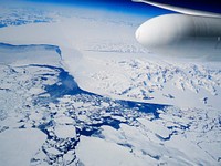
An iceberg trapped in sea ice in the Amundsen Sea. Original from NASA. Digitally enhanced by rawpixel.![View of the northern Antarctic Peninsula from high altitude during IceBridge's flight back from the Foundation Ice Stream…]() View of the northern Antarctic Peninsula from high altitude during IceBridge's flight back from the Foundation Ice Stream…
View of the northern Antarctic Peninsula from high altitude during IceBridge's flight back from the Foundation Ice Stream…![Ice on the Ellsworth Range in Antarctica as seen from the IceBridge DC-8 on Oct. 22, 2012. Original from NASA. Digitally…]() Ice on the Ellsworth Range in Antarctica as seen from the IceBridge DC-8 on Oct. 22, 2012. Original from NASA. Digitally…
Ice on the Ellsworth Range in Antarctica as seen from the IceBridge DC-8 on Oct. 22, 2012. Original from NASA. Digitally…![The U.S. Coast Guard Cutter Healy encountered only small patches of sea ice in the Chukchi Sea during the final days…]() The U.S. Coast Guard Cutter Healy encountered only small patches of sea ice in the Chukchi Sea during the final days…
The U.S. Coast Guard Cutter Healy encountered only small patches of sea ice in the Chukchi Sea during the final days…![Edge of an ice shelf in Adelaide Island, off the Antarctic Peninsula. Original from NASA. Digitally enhanced by rawpixel.]() Edge of an ice shelf in Adelaide Island, off the Antarctic Peninsula. Original from NASA. Digitally enhanced by rawpixel.
Edge of an ice shelf in Adelaide Island, off the Antarctic Peninsula. Original from NASA. Digitally enhanced by rawpixel.![On July 20, the U.S. Coast Guard Cutter Healy steamed south in the Arctic Ocean toward the edge of the sea ice. Original…]() On July 20, the U.S. Coast Guard Cutter Healy steamed south in the Arctic Ocean toward the edge of the sea ice. Original…
On July 20, the U.S. Coast Guard Cutter Healy steamed south in the Arctic Ocean toward the edge of the sea ice. Original…![A NASA scientific balloon awaits launch in McMurdo, Antarctica. Original from NASA. Digitally enhanced by rawpixel.]() A NASA scientific balloon awaits launch in McMurdo, Antarctica. Original from NASA. Digitally enhanced by rawpixel.
A NASA scientific balloon awaits launch in McMurdo, Antarctica. Original from NASA. Digitally enhanced by rawpixel.![Missionary Plains in Australia’s Northern Territory, a crater 24 kilometers in diameter and 5 kilometers deep.…]() Missionary Plains in Australia’s Northern Territory, a crater 24 kilometers in diameter and 5 kilometers deep.…
Missionary Plains in Australia’s Northern Territory, a crater 24 kilometers in diameter and 5 kilometers deep.…![Images of the Earth's land surface and surrounding coastal regions. Original from NASA. Digitally enhanced by rawpixel.]() Images of the Earth's land surface and surrounding coastal regions. Original from NASA. Digitally enhanced by rawpixel.
Images of the Earth's land surface and surrounding coastal regions. Original from NASA. Digitally enhanced by rawpixel.![Rare clear view of Alaska. Original from NASA. Digitally enhanced by rawpixel.]() Rare clear view of Alaska. Original from NASA. Digitally enhanced by rawpixel.
Rare clear view of Alaska. Original from NASA. Digitally enhanced by rawpixel.![Every southern spring and summer, after the Sun has risen into its 24-hour circuit around the skies of Antarctica, the Ross…]() Every southern spring and summer, after the Sun has risen into its 24-hour circuit around the skies of Antarctica, the Ross…
Every southern spring and summer, after the Sun has risen into its 24-hour circuit around the skies of Antarctica, the Ross…![Phytoplankton bloom in the Bay of Biscay. Original from NASA. Digitally enhanced by rawpixel.]() Phytoplankton bloom in the Bay of Biscay. Original from NASA. Digitally enhanced by rawpixel.
Phytoplankton bloom in the Bay of Biscay. Original from NASA. Digitally enhanced by rawpixel.![An iceberg embedded in sea ice as seen from the IceBridge DC-8 over the Bellingshausen Sea on Oct. 19, 2012. Original from…]() An iceberg embedded in sea ice as seen from the IceBridge DC-8 over the Bellingshausen Sea on Oct. 19, 2012. Original from…
An iceberg embedded in sea ice as seen from the IceBridge DC-8 over the Bellingshausen Sea on Oct. 19, 2012. Original from…![Climate change quote Facebook story]() Climate change quote Facebook story
Climate change quote Facebook story![Climate change quote poster]() Climate change quote poster
Climate change quote poster ![The Matusevich Glacier flows toward the coast of East Antarctica, pushing through a channel between the Lazarev Mountains…]() The Matusevich Glacier flows toward the coast of East Antarctica, pushing through a channel between the Lazarev Mountains…
The Matusevich Glacier flows toward the coast of East Antarctica, pushing through a channel between the Lazarev Mountains…![NASA image acquired August 17, 2010, the Northwest Passage almost free of ice. Original from NASA. Digitally enhanced by…]() NASA image acquired August 17, 2010, the Northwest Passage almost free of ice. Original from NASA. Digitally enhanced by…
NASA image acquired August 17, 2010, the Northwest Passage almost free of ice. Original from NASA. Digitally enhanced by…![In this mostly cloud-free true-color scene, much of Scandinavia can be seen to be still covered by snow. Original from NASA.…]() In this mostly cloud-free true-color scene, much of Scandinavia can be seen to be still covered by snow. Original from NASA.…
In this mostly cloud-free true-color scene, much of Scandinavia can be seen to be still covered by snow. Original from NASA.…![Baja California, Colorado river and Sonora Desert. Original from NASA. Digitally enhanced by rawpixel.]() Baja California, Colorado river and Sonora Desert. Original from NASA. Digitally enhanced by rawpixel.
Baja California, Colorado river and Sonora Desert. Original from NASA. Digitally enhanced by rawpixel.![NASA’s Operation IceBridge Completes Twin Polar Campaigns. Heimdal Glacier in southern Greenland. Original from NASA.…]() NASA’s Operation IceBridge Completes Twin Polar Campaigns. Heimdal Glacier in southern Greenland. Original from NASA.…
NASA’s Operation IceBridge Completes Twin Polar Campaigns. Heimdal Glacier in southern Greenland. Original from NASA.…![These rocks are famous because they move, leaving tell-tale trails in the clay, like this one. Original from NASA. Digitally…]() These rocks are famous because they move, leaving tell-tale trails in the clay, like this one. Original from NASA. Digitally…
These rocks are famous because they move, leaving tell-tale trails in the clay, like this one. Original from NASA. Digitally…![Remote sensing of ocean color in the Yellow Sea. Original from NASA. Digitally enhanced by rawpixel.]() Remote sensing of ocean color in the Yellow Sea. Original from NASA. Digitally enhanced by rawpixel.
Remote sensing of ocean color in the Yellow Sea. Original from NASA. Digitally enhanced by rawpixel.![Phytoplankton bloom off Newfoundland. Original from NASA. Digitally enhanced by rawpixel.]() Phytoplankton bloom off Newfoundland. Original from NASA. Digitally enhanced by rawpixel.
Phytoplankton bloom off Newfoundland. Original from NASA. Digitally enhanced by rawpixel.![Early Melt on the Greenland Ice Sheet . Original from NASA . Digitally enhanced by rawpixel.]() Early Melt on the Greenland Ice Sheet . Original from NASA . Digitally enhanced by rawpixel.
Early Melt on the Greenland Ice Sheet . Original from NASA . Digitally enhanced by rawpixel.![Arrival of the RRS Ernest Shackleton near Halley Research Station in Antarctica, January, 2013. Original from NASA.…]() Arrival of the RRS Ernest Shackleton near Halley Research Station in Antarctica, January, 2013. Original from NASA.…
Arrival of the RRS Ernest Shackleton near Halley Research Station in Antarctica, January, 2013. Original from NASA.…![Akpatok Island in Ungava Bay in northern Quebec, Canada. Original from NASA. Digitally enhanced by rawpixel.]() Akpatok Island in Ungava Bay in northern Quebec, Canada. Original from NASA. Digitally enhanced by rawpixel.
Akpatok Island in Ungava Bay in northern Quebec, Canada. Original from NASA. Digitally enhanced by rawpixel.![View of the Arctic waters and the far northern lands surrounding it. Original from NASA. Digitally enhanced by rawpixel.]() View of the Arctic waters and the far northern lands surrounding it. Original from NASA. Digitally enhanced by rawpixel.
View of the Arctic waters and the far northern lands surrounding it. Original from NASA. Digitally enhanced by rawpixel.![Massive congregations of greenish phytoplankton swirl in the dark water around Gotland, a Swedish island in the Baltic Sea.…]() Massive congregations of greenish phytoplankton swirl in the dark water around Gotland, a Swedish island in the Baltic Sea.…
Massive congregations of greenish phytoplankton swirl in the dark water around Gotland, a Swedish island in the Baltic Sea.…![NASA/Goddard Space Flight Center/Reto Stöckli's amazingly beautiful view of Earth from space. October 9th, 2007.…]() NASA/Goddard Space Flight Center/Reto Stöckli's amazingly beautiful view of Earth from space. October 9th, 2007.…
NASA/Goddard Space Flight Center/Reto Stöckli's amazingly beautiful view of Earth from space. October 9th, 2007.…![NASA Launches Eighth Year of Antarctic Ice Change Airborne Survey. Original from NASA . Digitally enhanced by rawpixel.]() NASA Launches Eighth Year of Antarctic Ice Change Airborne Survey. Original from NASA . Digitally enhanced by rawpixel.
NASA Launches Eighth Year of Antarctic Ice Change Airborne Survey. Original from NASA . Digitally enhanced by rawpixel.![Hurricane Gonzalo's northern quadrant over Bermuda. Original from NASA. Digitally enhanced by rawpixel.]() Hurricane Gonzalo's northern quadrant over Bermuda. Original from NASA. Digitally enhanced by rawpixel.
Hurricane Gonzalo's northern quadrant over Bermuda. Original from NASA. Digitally enhanced by rawpixel.![Along the southeastern coast of Greenland, an intricate network of fjords funnels glacial ice to the Atlantic Ocean.…]() Along the southeastern coast of Greenland, an intricate network of fjords funnels glacial ice to the Atlantic Ocean.…
Along the southeastern coast of Greenland, an intricate network of fjords funnels glacial ice to the Atlantic Ocean.…![Images of the Earth's land surface and surrounding coastal regions. Original from NASA. Digitally enhanced by rawpixel.]() Images of the Earth's land surface and surrounding coastal regions. Original from NASA. Digitally enhanced by rawpixel.
Images of the Earth's land surface and surrounding coastal regions. Original from NASA. Digitally enhanced by rawpixel.![The terrain for the scientific work conducted by ICESCAPE scientists on July 4, 2010. Original from NASA. Digitally enhanced…]() The terrain for the scientific work conducted by ICESCAPE scientists on July 4, 2010. Original from NASA. Digitally enhanced…
The terrain for the scientific work conducted by ICESCAPE scientists on July 4, 2010. Original from NASA. Digitally enhanced…![The northernmost land in the world is located in Pearyland, Greenland. Original from NASA. Digitally enhanced by rawpixel.]() The northernmost land in the world is located in Pearyland, Greenland. Original from NASA. Digitally enhanced by rawpixel.
The northernmost land in the world is located in Pearyland, Greenland. Original from NASA. Digitally enhanced by rawpixel.![NASA Blue Marble 2007 West captured by the Moderate Resolution Imaging Spectroradiometer on NASA’s Terra satellite in…]() NASA Blue Marble 2007 West captured by the Moderate Resolution Imaging Spectroradiometer on NASA’s Terra satellite in…
NASA Blue Marble 2007 West captured by the Moderate Resolution Imaging Spectroradiometer on NASA’s Terra satellite in…![GOES 11 satellite image showing earth on March 25, 2010. Original from NASA. Digitally enhanced by rawpixel.]() GOES 11 satellite image showing earth on March 25, 2010. Original from NASA. Digitally enhanced by rawpixel.
GOES 11 satellite image showing earth on March 25, 2010. Original from NASA. Digitally enhanced by rawpixel.![Drawing on data from multiple satellite missions a team of NASA scientists and graphic artists created this globe and the…]() Drawing on data from multiple satellite missions a team of NASA scientists and graphic artists created this globe and the…
Drawing on data from multiple satellite missions a team of NASA scientists and graphic artists created this globe and the…![MODIS on the Aqua satellite captured this stunning view of Japans four largest islands on February 20, 2004. Original from…]() MODIS on the Aqua satellite captured this stunning view of Japans four largest islands on February 20, 2004. Original from…
MODIS on the Aqua satellite captured this stunning view of Japans four largest islands on February 20, 2004. Original from…![Mountain ridges showing the distinctive geology of the Geikie Plateau region in eastern Greenland. Original from NASA.…]() Mountain ridges showing the distinctive geology of the Geikie Plateau region in eastern Greenland. Original from NASA.…
Mountain ridges showing the distinctive geology of the Geikie Plateau region in eastern Greenland. Original from NASA.…![NASA GOES 12 satellite image showing earth on March 30, 2010. Original from NASA. Digitally enhanced by rawpixel.]() NASA GOES 12 satellite image showing earth on March 30, 2010. Original from NASA. Digitally enhanced by rawpixel.
NASA GOES 12 satellite image showing earth on March 30, 2010. Original from NASA. Digitally enhanced by rawpixel.![GOES 12 satellite image showing earth on March 25, 2010. Original from NASA . Digitally enhanced by rawpixel.]() GOES 12 satellite image showing earth on March 25, 2010. Original from NASA . Digitally enhanced by rawpixel.
GOES 12 satellite image showing earth on March 25, 2010. Original from NASA . Digitally enhanced by rawpixel.![Cloud vortices off Madeira and Canary Islands. Original from NASA. Digitally enhanced by rawpixel.]() Cloud vortices off Madeira and Canary Islands. Original from NASA. Digitally enhanced by rawpixel.
Cloud vortices off Madeira and Canary Islands. Original from NASA. Digitally enhanced by rawpixel.![The Earth created by various layers of satellite footage. Original from NASA. Digitally enhanced by rawpixel.]() The Earth created by various layers of satellite footage. Original from NASA. Digitally enhanced by rawpixel.
The Earth created by various layers of satellite footage. Original from NASA. Digitally enhanced by rawpixel.![NASA and NOAA satellites are studying the triple tropical tempests that are now romping through the Eastern Pacific Ocean.…]() NASA and NOAA satellites are studying the triple tropical tempests that are now romping through the Eastern Pacific Ocean.…
NASA and NOAA satellites are studying the triple tropical tempests that are now romping through the Eastern Pacific Ocean.…![Ireland on the first day this summer. Original from NASA. Digitally enhanced by rawpixel.]() Ireland on the first day this summer. Original from NASA. Digitally enhanced by rawpixel.
Ireland on the first day this summer. Original from NASA. Digitally enhanced by rawpixel.![The Lena River, some 2,800 miles long, is one of the largest rivers in the world. Original from NASA. Digitally enhanced by…]() The Lena River, some 2,800 miles long, is one of the largest rivers in the world. Original from NASA. Digitally enhanced by…
The Lena River, some 2,800 miles long, is one of the largest rivers in the world. Original from NASA. Digitally enhanced by…![GOES 12 satellite image showing earth on March 25, 2010. Original from NASA. Digitally enhanced by rawpixel.]() GOES 12 satellite image showing earth on March 25, 2010. Original from NASA. Digitally enhanced by rawpixel.
GOES 12 satellite image showing earth on March 25, 2010. Original from NASA. Digitally enhanced by rawpixel.![ICESCAPE scientists watched from the deck of the Healy as it cut a path through thick multiyear ice on July 6, 2011.…]() ICESCAPE scientists watched from the deck of the Healy as it cut a path through thick multiyear ice on July 6, 2011.…
ICESCAPE scientists watched from the deck of the Healy as it cut a path through thick multiyear ice on July 6, 2011.…![GOES 11 satellite image showing earth on March 25, 2010. Original from NASA. Digitally enhanced by rawpixel.]() GOES 11 satellite image showing earth on March 25, 2010. Original from NASA. Digitally enhanced by rawpixel.
GOES 11 satellite image showing earth on March 25, 2010. Original from NASA. Digitally enhanced by rawpixel.![Wave Clouds over Ireland. Original from NASA. Digitally enhanced by rawpixel.]() Wave Clouds over Ireland. Original from NASA. Digitally enhanced by rawpixel.
Wave Clouds over Ireland. Original from NASA. Digitally enhanced by rawpixel.![Earth's shadow blocking the sun light captured by NASA on April 3rd, 2011. Original from NASA. Digitally enhanced by…]() Earth's shadow blocking the sun light captured by NASA on April 3rd, 2011. Original from NASA. Digitally enhanced by…
Earth's shadow blocking the sun light captured by NASA on April 3rd, 2011. Original from NASA. Digitally enhanced by…![Glacier washi tape design on white background]() Glacier washi tape design on white background
Glacier washi tape design on white background![Eruption of Cleveland Volcano, Aleutian Islands, Alaska. Original from NASA. Digitally enhanced by rawpixel.]() Eruption of Cleveland Volcano, Aleutian Islands, Alaska. Original from NASA. Digitally enhanced by rawpixel.
Eruption of Cleveland Volcano, Aleutian Islands, Alaska. Original from NASA. Digitally enhanced by rawpixel.![Ellesmere Island, which is part of the Qikiqtaaluk Region of the Canadian territory of Nunavut. Original from NASA.…]() Ellesmere Island, which is part of the Qikiqtaaluk Region of the Canadian territory of Nunavut. Original from NASA.…
Ellesmere Island, which is part of the Qikiqtaaluk Region of the Canadian territory of Nunavut. Original from NASA.…![Apollo 9 Mission image - S0-65 Multispectral Photography - New Mexico. Original from NASA. Digitally enhanced by rawpixel.]() Apollo 9 Mission image - S0-65 Multispectral Photography - New Mexico. Original from NASA. Digitally enhanced by rawpixel.
Apollo 9 Mission image - S0-65 Multispectral Photography - New Mexico. Original from NASA. Digitally enhanced by rawpixel.![This is a composite image of NGC 1068, one of the nearest and brightest galaxies containing a rapidly growing supermassive…]() This is a composite image of NGC 1068, one of the nearest and brightest galaxies containing a rapidly growing supermassive…
This is a composite image of NGC 1068, one of the nearest and brightest galaxies containing a rapidly growing supermassive…![Planet Earth at day, isolated object]() Planet Earth at day, isolated object
Planet Earth at day, isolated object![Planet Earth at day isolated object psd]() Planet Earth at day isolated object psd
Planet Earth at day isolated object psd![Great Ball of Fire - Activity from August 1 CME Subsides. Original from NASA. Digitally enhanced by rawpixel.]() Great Ball of Fire - Activity from August 1 CME Subsides. Original from NASA. Digitally enhanced by rawpixel.
Great Ball of Fire - Activity from August 1 CME Subsides. Original from NASA. Digitally enhanced by rawpixel.![Lake Mackay, the largest of hundreds of ephemeral lakes scattered throughout Western Australia and the Northern Territory.…]() Lake Mackay, the largest of hundreds of ephemeral lakes scattered throughout Western Australia and the Northern Territory.…
Lake Mackay, the largest of hundreds of ephemeral lakes scattered throughout Western Australia and the Northern Territory.…![PNG glacier washi tape, journal sticker element, transparent background]() PNG glacier washi tape, journal sticker element, transparent background
PNG glacier washi tape, journal sticker element, transparent background![Png planet Earth at day, isolated object, transparent background]() Png planet Earth at day, isolated object, transparent background
Png planet Earth at day, isolated object, transparent background![Earth paper element with white border]() Earth paper element with white border
Earth paper element with white border ![A colony of Magellanic penguins near Punta Arenas, Chile. Original from NASA. Digitally enhanced by rawpixel.]() A colony of Magellanic penguins near Punta Arenas, Chile. Original from NASA. Digitally enhanced by rawpixel.
A colony of Magellanic penguins near Punta Arenas, Chile. Original from NASA. Digitally enhanced by rawpixel.![The Channel Tunnel, a 50.5 km-long rail tunnel beneath the English Channel at the Straits of Dover. Original from NASA.…]() The Channel Tunnel, a 50.5 km-long rail tunnel beneath the English Channel at the Straits of Dover. Original from NASA.…
The Channel Tunnel, a 50.5 km-long rail tunnel beneath the English Channel at the Straits of Dover. Original from NASA.…![NASA satellite tracks underwater volcanic eruption in Canary Islands. Original from NASA. Digitally enhanced by rawpixel.]() NASA satellite tracks underwater volcanic eruption in Canary Islands. Original from NASA. Digitally enhanced by rawpixel.
NASA satellite tracks underwater volcanic eruption in Canary Islands. Original from NASA. Digitally enhanced by rawpixel.![Grand Turk Island is an island in the Turks and Caicos Islands in the Caribbean, and contains the territory's capital…]() Grand Turk Island is an island in the Turks and Caicos Islands in the Caribbean, and contains the territory's capital…
Grand Turk Island is an island in the Turks and Caicos Islands in the Caribbean, and contains the territory's capital…![PNG Earth sticker with white border, transparent background]() PNG Earth sticker with white border, transparent background
PNG Earth sticker with white border, transparent background ![Saunders Island and Wolstenholme Fjord with Kap Atholl in the background. Original from NASA. Digitally enhanced by rawpixel.]() Saunders Island and Wolstenholme Fjord with Kap Atholl in the background. Original from NASA. Digitally enhanced by rawpixel.
Saunders Island and Wolstenholme Fjord with Kap Atholl in the background. Original from NASA. Digitally enhanced by rawpixel.![Greens and blues of the ocean color from NASA satellite data. Original from NASA. Digitally enhanced by rawpixel.]() Greens and blues of the ocean color from NASA satellite data. Original from NASA. Digitally enhanced by rawpixel.
Greens and blues of the ocean color from NASA satellite data. Original from NASA. Digitally enhanced by rawpixel.![Image of the sun while spewing streams of particles for over two days (Aug. 17-19, 2015) before breaking apart. Original…]() Image of the sun while spewing streams of particles for over two days (Aug. 17-19, 2015) before breaking apart. Original…
Image of the sun while spewing streams of particles for over two days (Aug. 17-19, 2015) before breaking apart. Original…![Like rivers of liquid water, glaciers flow downhill, with tributaries joining to form larger rivers. Original from NASA.…]() Like rivers of liquid water, glaciers flow downhill, with tributaries joining to form larger rivers. Original from NASA.…
Like rivers of liquid water, glaciers flow downhill, with tributaries joining to form larger rivers. Original from NASA.…![Earth observation by the crew of the International Space Station. Original from NASA. Digitally enhanced by rawpixel.]() Earth observation by the crew of the International Space Station. Original from NASA. Digitally enhanced by rawpixel.
Earth observation by the crew of the International Space Station. Original from NASA. Digitally enhanced by rawpixel.![Dendi Caldera, Ethiopia is featured in this image photographed by an Expedition 16 crew member on the International Space…]() Dendi Caldera, Ethiopia is featured in this image photographed by an Expedition 16 crew member on the International Space…
Dendi Caldera, Ethiopia is featured in this image photographed by an Expedition 16 crew member on the International Space…![A plume at Shiveluch Volcano, Kamchatka Peninsula, Russia. Original from NASA. Digitally enhanced by rawpixel.]() A plume at Shiveluch Volcano, Kamchatka Peninsula, Russia. Original from NASA. Digitally enhanced by rawpixel.
A plume at Shiveluch Volcano, Kamchatka Peninsula, Russia. Original from NASA. Digitally enhanced by rawpixel.![View of the Salt Lake City, Utah area. Original from NASA. Digitally enhanced by rawpixel.]() View of the Salt Lake City, Utah area. Original from NASA. Digitally enhanced by rawpixel.
View of the Salt Lake City, Utah area. Original from NASA. Digitally enhanced by rawpixel.![This image from NASA's Terra spacecraft shows the Kuk Early Agricultural Site in the western highlands of New Guinea.…]() This image from NASA's Terra spacecraft shows the Kuk Early Agricultural Site in the western highlands of New Guinea.…
This image from NASA's Terra spacecraft shows the Kuk Early Agricultural Site in the western highlands of New Guinea.…![Longyearbyen, the largest island of the Svalbard archipelago, part of the Kingdom of Norway. Original from NASA. Digitally…]() Longyearbyen, the largest island of the Svalbard archipelago, part of the Kingdom of Norway. Original from NASA. Digitally…
Longyearbyen, the largest island of the Svalbard archipelago, part of the Kingdom of Norway. Original from NASA. Digitally…![Lake Naivasha, 90km north-west of Nairobi. Original from NASA. Digitally enhanced by rawpixel.]() Lake Naivasha, 90km north-west of Nairobi. Original from NASA. Digitally enhanced by rawpixel.
Lake Naivasha, 90km north-west of Nairobi. Original from NASA. Digitally enhanced by rawpixel.![NASA's Wallops Flight Facility is located on Wallops Island. Satellite imagery from NOAA's GOES-East satellite shows that…]() NASA's Wallops Flight Facility is located on Wallops Island. Satellite imagery from NOAA's GOES-East satellite shows that…
NASA's Wallops Flight Facility is located on Wallops Island. Satellite imagery from NOAA's GOES-East satellite shows that…![The Arctic Circle cuts through the western coast of Norway and the Saltfjellet-Svartisen National Park. Original from NASA.…]() The Arctic Circle cuts through the western coast of Norway and the Saltfjellet-Svartisen National Park. Original from NASA.…
The Arctic Circle cuts through the western coast of Norway and the Saltfjellet-Svartisen National Park. Original from NASA.…![Nadir view of the southern Cape District of South Africa. Original from NASA. Digitally enhanced by rawpixel.]() Nadir view of the southern Cape District of South Africa. Original from NASA. Digitally enhanced by rawpixel.
Nadir view of the southern Cape District of South Africa. Original from NASA. Digitally enhanced by rawpixel.![The Kondyor Massif is located in Eastern Siberia, Russia, north of the city of Khabarovsk. Original from NASA. Digitally…]() The Kondyor Massif is located in Eastern Siberia, Russia, north of the city of Khabarovsk. Original from NASA. Digitally…
The Kondyor Massif is located in Eastern Siberia, Russia, north of the city of Khabarovsk. Original from NASA. Digitally…![On August 22, 2014 the Moderate Resolution Imaging Spectroradiometer aboard NASA’s Terra satellite captured a true…]() On August 22, 2014 the Moderate Resolution Imaging Spectroradiometer aboard NASA’s Terra satellite captured a true…
On August 22, 2014 the Moderate Resolution Imaging Spectroradiometer aboard NASA’s Terra satellite captured a true…![Moon crossing in front of its view of the sun captured by NASA’s Solar Dynamics Observatory (SDO) on Jan 30th, 2014.…]() Moon crossing in front of its view of the sun captured by NASA’s Solar Dynamics Observatory (SDO) on Jan 30th, 2014.…
Moon crossing in front of its view of the sun captured by NASA’s Solar Dynamics Observatory (SDO) on Jan 30th, 2014.…![Lying in the eastern Mediterranean Sea, the entire Island of Crete (35.0N, 25.0E) can be seen in great detail in this cloud…]() Lying in the eastern Mediterranean Sea, the entire Island of Crete (35.0N, 25.0E) can be seen in great detail in this cloud…
Lying in the eastern Mediterranean Sea, the entire Island of Crete (35.0N, 25.0E) can be seen in great detail in this cloud…![The meandering Ohio River bisecting this image is the border between Kentucky and Indiana. Original from NASA. Digitally…]() The meandering Ohio River bisecting this image is the border between Kentucky and Indiana. Original from NASA. Digitally…
The meandering Ohio River bisecting this image is the border between Kentucky and Indiana. Original from NASA. Digitally…![This image from NASA's EarthKAM captures almost all of Quinghai, the largest lake in China. Original from NASA. Digitally…]() This image from NASA's EarthKAM captures almost all of Quinghai, the largest lake in China. Original from NASA. Digitally…
This image from NASA's EarthKAM captures almost all of Quinghai, the largest lake in China. Original from NASA. Digitally…![The Isthmus of Corinth has played a very important role in the history of Greece. Original from NASA. Digitally enhanced by…]() The Isthmus of Corinth has played a very important role in the history of Greece. Original from NASA. Digitally enhanced by…
The Isthmus of Corinth has played a very important role in the history of Greece. Original from NASA. Digitally enhanced by…![This image from NASA's EarthKAM shows Lisbon, the capital of Portugal. Original from NASA. Digitally enhanced by rawpixel.]() This image from NASA's EarthKAM shows Lisbon, the capital of Portugal. Original from NASA. Digitally enhanced by rawpixel.
This image from NASA's EarthKAM shows Lisbon, the capital of Portugal. Original from NASA. Digitally enhanced by rawpixel.