The Wilkins Ice Shelf on the western side of the Antarctic Peninsula. Original from NASA. Digitally enhanced by rawpixel. https://www.rawpixel.com/image/441236/free-photo-image-maps-snow-advanced-spaceborne-thermal-emission-and-reflection-radiometer-aster Free Image from public domain license
The Rio Tinto river in southwestern Spain. Original from NASA. Digitally enhanced by rawpixel. https://www.rawpixel.com/image/441261/free-photo-image-spain-rio-tinto-satellite-climate-change Free Image from public domain license
Image formed by the Advanced Spaceborne Thermal Emission and Reflection Radiometer (ASTER) and Global Digital Elevation… https://www.rawpixel.com/image/441205/free-photo-image-world-map-digital Free Image from public domain license
Global Digital Elevation Model. Original from NASA. Digitally enhanced by rawpixel. https://www.rawpixel.com/image/441216/free-photo-image-atlas-thermal-imaging-globe Free Image from public domain license
This spaceborne radar image shows the area just north of the city of Cairo, Egypt, where the Nile River splits into two main… https://www.rawpixel.com/image/441541/free-photo-image-nasa-map-city-maps Free Image from public domain license
NASA Shuttle Radar Topography Mission imaged Sendai, the capital city of Japan Miyagi Prefecture a magnitude 8.9 earthquake… https://www.rawpixel.com/image/441250/free-photo-image-topography-earthquake-japan Free Image from public domain license
The payload bay of the orbiting space shuttle Endeavour with an area of the Pacific Ocean northeast of Hawaii in the… https://www.rawpixel.com/image/441561/free-photo-image-aerospace-space-shuttle-astronaut Free Image from public domain license
View of Florence, Italy area from the Skylab. Original from NASA. Digitally enhanced by rawpixel. https://www.rawpixel.com/image/441546/free-photo-image-nasa-map-florence Free Image from public domain license
Ellesmere Island, which is part of the Qikiqtaaluk Region of the Canadian territory of Nunavut. Original from NASA.… https://www.rawpixel.com/image/440667/free-photo-image-maps-nasa-earth-map Free Image from public domain license
Thailand floods monitored by a NASA satellite. Original from NASA. Digitally enhanced by rawpixel. https://www.rawpixel.com/image/441275/free-photo-image-nasa-map-river-bank Free Image from public domain license
The Sustina Glacier in the Alaska Range. Original from NASA. Digitally enhanced by rawpixel. https://www.rawpixel.com/image/441244/free-photo-image-nasa-maps-valley Free Image from public domain license
Image acquired by NASA's Terra spacecraft of the Sierra Leone estuary. Original from NASA. Digitally enhanced by rawpixel. https://www.rawpixel.com/image/418644/sierra-leone-estuary-space-view Free Image from public domain license
Santo Domingo, the capital of the Dominican Republic. Original from NASA. Digitally enhanced by rawpixel. https://www.rawpixel.com/image/440567/free-photo-image-dominican-republic-christopher-columbus Free Image from public domain license
Heilongjiang, a province of China located in the northeastern part of the country. Original from NASA. Digitally enhanced by… https://www.rawpixel.com/image/440587/heilongjiang-province-space-view Free Image from public domain license
The Channel Tunnel, a 50.5 km-long rail tunnel beneath the English Channel at the Straits of Dover. Original from NASA.… https://www.rawpixel.com/image/441134/channel-tunnel-space-view Free Image from public domain license
Aaland archipelago at the mouth of the Gulf of Bothnia which belongs to Finland. Original from NASA. Digitally enhanced by… https://www.rawpixel.com/image/441242/free-photo-image-nasa-nasa-earth-helsinki Free Image from public domain license
Brasilia, the capital of Brazil. Original from NASA. Digitally enhanced by rawpixel. https://www.rawpixel.com/image/441221/free-photo-image-brazil-brasilia-city-map Free Image from public domain license
The Musandam Peninsula, part of Oman. Original from NASA. Digitally enhanced by rawpixel. https://www.rawpixel.com/image/441188/free-photo-image-map-nasa-earth-landscape Free Image from public domain license
Image from NASA's Terra spacecraft of Franz Josef Land, an archipelago in the far north of Russia. Original from NASA.… https://www.rawpixel.com/image/441324/free-photo-image-maps-nasa-russia Free Image from public domain license
NASA satellite tracks underwater volcanic eruption in Canary Islands. Original from NASA. Digitally enhanced by rawpixel. https://www.rawpixel.com/image/441274/free-photo-image-ocean-underwater-climate-change Free Image from public domain license
This image from NASA's Terra spacecraft shows Beihai, a city in the south of Guangxi, People's republic of China. Original… https://www.rawpixel.com/image/440652/free-photo-image-map-nasa-china Free Image from public domain license
Hurricane Matthew. This is a visible image of Major Hurricane Matthew taken from NASA's Terra satellite on Oct. 7 at 12 p.m.… https://www.rawpixel.com/image/440032/free-photo-image-hurricane-disaster-map Free Image from public domain license
Torrential rains in the mid-South of the United States in mid-March 2016 produced flooding throughout Texas, Louisiana and… https://www.rawpixel.com/image/440664/free-photo-image-nasa-louisiana-space Free Image from public domain license
Grand Turk Island is an island in the Turks and Caicos Islands in the Caribbean, and contains the territory's capital… https://www.rawpixel.com/image/441237/free-photo-image-nasa-2001-maps Free Image from public domain license
Sankt Wolfgang im Salzkammergut, Austria. Original public domain image from Wikimedia Commons https://www.rawpixel.com/image/3304949/free-photo-image-nature-hiking-aerial-view-austria Free Image from public domain license
Teshekpuk Lake on Alaska's North Slope, within the National Petroleum Reserve. Original from NASA. Digitally enhanced by… https://www.rawpixel.com/image/441144/free-photo-image-science-alaska-world-map Free Image from public domain license
Los Angeles and vicinity seen from space on May 4, 2001. Original from NASA. Digitally enhanced by rawpixel. https://www.rawpixel.com/image/440540/free-photo-image-topography-los-angeles-map-radar Free Image from public domain license
Jamestown, located on Jamestown Island in the Virginia Colony. Original from NASA. Digitally enhanced by rawpixel. https://www.rawpixel.com/image/441199/jamestown-space-view Free Image from public domain license
NASA's Terra spacecraft captured this image of the city of Arkhangelsk and administrative capital of Archangelsk Oblast… https://www.rawpixel.com/image/441238/free-photo-image-river-map-landscape Free Image from public domain license
The eastern hemisphere was captured on March 30, 2014, by the Visible Infrared Imaging Radiometer Suite on the Suomi NPP… https://www.rawpixel.com/image/440136/earth Free Image from public domain license
Al Jazirah (also Gezira) is one of the 26 states of Sudan. Original from NASA. Digitally enhanced by rawpixel. https://www.rawpixel.com/image/441167/free-photo-image-map-nasa-blue Free Image from public domain license
Oslo, the capital and largest city in Norway. Original from NASA. Digitally enhanced by rawpixel. https://www.rawpixel.com/image/441269/free-photo-image-cc0-city-climate-change Free Image from public domain license
Clear shot of every parcel of Earth’s land surface and islands in nighttime view in visible light. A composite of… https://www.rawpixel.com/image/440239/earth-night Free Image from public domain license
The city of Sukkur, Pakistan. Original from NASA. Digitally enhanced by rawpixel. https://www.rawpixel.com/image/441254/free-photo-image-flood-maps-august-2010 Free Image from public domain license
Simulated natural color image of Huron, South Dakota, captured by NASA's Terra spacecraft. Original from NASA. Digitally… https://www.rawpixel.com/image/441231/free-photo-image-south-dakota-satellite-aerial Free Image from public domain license
Rostov-on-Don, a Russian City on the Don River, 32 kilometers from the Sea of Azov. Original from NASA. Digitally enhanced… https://www.rawpixel.com/image/440623/free-photo-image-nasa-map-world Free Image from public domain license
Nuuk (or Gadthab) is the capital and largest city of Greenland. Original from NASA. Digitally enhanced by rawpixel https://www.rawpixel.com/image/441177/free-photo-image-space-earth-aerial-view Free Image from public domain license
The Arctic Circle cuts through the western coast of Norway and the Saltfjellet-Svartisen National Park. Original from NASA.… https://www.rawpixel.com/image/441172/free-photo-image-nasa-climate-change-aerial Free Image from public domain license
This image from NASA's Terra spacecraft shows the Kuk Early Agricultural Site in the western highlands of New Guinea.… https://www.rawpixel.com/image/441178/free-photo-image-swamp-nasa-climate-change Free Image from public domain license
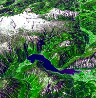
Lake Naivasha, 90km north-west of Nairobi. Original from NASA. Digitally enhanced by rawpixel. https://www.rawpixel.com/image/441152/free-photo-image-kenya-nasa-lake-satellite-landscape Free Image from public domain license
The Uvs Nuur Basin in Mongolia and the Russian Federation. Original from NASA. Digitally enhanced by rawpixel. https://www.rawpixel.com/image/439971/free-photo-image-nasa-maps-earth-observations Free Image from public domain license
The Kondyor Massif is located in Eastern Siberia, Russia, north of the city of Khabarovsk. Original from NASA. Digitally… https://www.rawpixel.com/image/441148/free-photo-image-map-nasa-russia Free Image from public domain license
Longyearbyen, the largest island of the Svalbard archipelago, part of the Kingdom of Norway. Original from NASA. Digitally… https://www.rawpixel.com/image/439954/free-photo-image-nasa-norway-mountains-world-map Free Image from public domain license
The Isthmus of Corinth has played a very important role in the history of Greece. Original from NASA. Digitally enhanced by… https://www.rawpixel.com/image/441129/free-photo-image-nasa-greece-maps Free Image from public domain license
Image showing the west coast of Greenland, one of Earth's premiere incubators for icebergs. Original from NASA. Digitally… https://www.rawpixel.com/image/441795/free-photo-image-aerial-view-maps Free Image from public domain license
Lake Ilopango, a crater lake which fills a volcanic caldera in central El Salvador. Original from NASA. Digitally enhanced… https://www.rawpixel.com/image/440647/free-photo-image-salvador-satellite-lake Free Image from public domain license
Sheveluch Volcano in Kamchatka, Siberia. Original from NASA. Digitally enhanced by rawpixel. https://www.rawpixel.com/image/441226/free-photo-image-map-volcano-nasa Free Image from public domain license
Aerial view of Berlin, acquired by NASA's Terra spacecraft. Original from NASA. Digitally enhanced by rawpixel. https://www.rawpixel.com/image/441098/free-photo-image-maps-berlin-nasa-stadium Free Image from public domain license
Attu, the westernmost Aleutian island, is nearly 1760 km from the Alaskan mainland. Original from NASA. Digitally enhanced… https://www.rawpixel.com/image/441125/free-photo-image-nasa-map-space-earth Free Image from public domain license
Rock and peaks topped with snow in Gmunden, Austria. Original public domain image from Wikimedia Commons https://www.rawpixel.com/image/3287997/free-photo-image-abies-austria-berg Free Image from public domain license
Delhi, the second largest metropolis in India, with a population of 16 million. Original from NASA. Digitally enhanced by… https://www.rawpixel.com/image/441145/free-photo-image-map-satellite-maps-public-domain-high-resolution-landscape Free Image from public domain license
Flood waters in Bangkok as the Ayutthaya River overflowed its banks. Original from NASA. Digitally enhanced by rawpixel. https://www.rawpixel.com/image/440502/free-photo-image-maps-background-flood Free Image from public domain license
Guangxi Province in southeast China. Original from NASA. Digitally enhanced by rawpixel. https://www.rawpixel.com/image/440654/guangxi-provine-space-view Free Image from public domain license
The flooding from the Chao Phraya River, Thailand on Nov. 17, 2011. Original from NASA. Digitally enhanced by rawpixel. https://www.rawpixel.com/image/440511/free-photo-image-nasa-background-2011 Free Image from public domain license
Flooding from the Chao Phraya River, Thailand on Nov. 1, 2011. Original from NASA. Digitally enhanced by rawpixel. https://www.rawpixel.com/image/440508/free-photo-image-nasa-map-thailand Free Image from public domain license
The northernmost land in the world is located in Pearyland, Greenland. Original from NASA. Digitally enhanced by rawpixel. https://www.rawpixel.com/image/441198/free-photo-image-nasa-snow-greenland-nature Free Image from public domain license
The Mackenzie River in the Northwest Territories, Canada. Original from NASA. Digitally enhanced by rawpixel. https://www.rawpixel.com/image/439973/map-green-terrain-canada Free Image from public domain license
The Ouachita Mountains in southeast Oklahoma. Original from NASA. Digitally enhanced by rawpixel. https://www.rawpixel.com/image/441267/free-photo-image-nasa-map-oklahoma Free Image from public domain license
On August 22, 2014 the Moderate Resolution Imaging Spectroradiometer aboard NASA’s Terra satellite captured a true… https://www.rawpixel.com/image/440172/free-photo-image-nasa-iceland-satellite Free Image from public domain license
The John F. Kennedy Space Center, America's spaceport, is located along Florida's eastern shore on Cape Canaveral. Original… https://www.rawpixel.com/image/441135/free-photo-image-florida-florida-maps-public-domain-map Free Image from public domain license
Phytoplankton bloom off Newfoundland. Original from NASA. Digitally enhanced by rawpixel. https://www.rawpixel.com/image/440201/phytoplankton-bloom-off-newfoundland Free Image from public domain license
Lake Mackay, the largest of hundreds of ephemeral lakes scattered throughout Western Australia and the Northern Territory.… https://www.rawpixel.com/image/440591/free-photo-image-nasa-map-earth Free Image from public domain license
A penguin near Punta Arena, Chile. Original from NASA. Digitally enhanced by rawpixel. https://www.rawpixel.com/image/440046/free-photo-image-penguin-forest-arena Free Image from public domain license
A nearly cloud-free image of Iceland. Original from NASA. Digitally enhanced by rawpixel. https://www.rawpixel.com/image/440163/free-photo-image-iceland-nasa-nasa-earth Free Image from public domain license
A butterfly photographed in the La Selva region of the Costa Rican rain forest.. Original from NASA . Digitally enhanced by… https://www.rawpixel.com/image/440029/free-photo-image-butterfly-insect-selva Free Image from public domain license
A Grumman OV-1B Mohawk maps Great Lakes’ ice flows for the National Aeronautics and Space Administration (NASA) Lewis… https://www.rawpixel.com/image/441687/free-photo-image-nasa-air-force-aircraft Free Image from public domain license
A fox at Torres del Paine National Park in Chile. Original from NASA. Digitally enhanced by rawpixel. https://www.rawpixel.com/image/440016/free-photo-image-fox-jungle-chile Free Image from public domain license
Pyroclastic Flow Remnants at Shiveluch Volcano. Original from NASA. Digitally enhanced by rawpixel. https://www.rawpixel.com/image/440238/free-photo-image-avalanche-volcano-february-2011 Free Image from public domain license
A herd of guanacos in Torres del Paine National Park in Chile. Original from NASA. Digitally enhanced by rawpixel. https://www.rawpixel.com/image/439985/herd-guanacos Free Image from public domain license
NASA-NOAA's Suomi NPP Satellite Gets Colorful Look at Hurricane Blanca. Original from NASA. Digitally enhanced by rawpixel. https://www.rawpixel.com/image/440152/free-photo-image-hurricane-nasa-storm Free Image from public domain license
The city of Chateaubriant, France. Original from NASA. Digitally enhanced by rawpixel. https://www.rawpixel.com/image/441218/free-photo-image-city-satellite-climate-change-cc0 Free Image from public domain license
On Feb. 12, 2010, the 21st Winter Olympic Games opened in the city of Vancouver, British Columbia, Canada. NASA's Terra… https://www.rawpixel.com/image/441191/free-photo-image-british-columbia-vancouver-september-2008 Free Image from public domain license
The Republic of Seychelles, an island country with an archipelago of 115 islands. Original from NASA. Digitally enhanced by… https://www.rawpixel.com/image/441306/free-photo-image-seychelles-archipelago-clouds-satellite Free Image from public domain license
The Indonesian islands of Komodo, Rintja, Padar, and Flores in the Komodo National Park. Original from NASA. Digitally… https://www.rawpixel.com/image/441183/free-photo-image-flores-indonesian-nationality-dragon Free Image from public domain license
The Jizzax Province in eastern Uzbekistan. Original from NASA. Digitally enhanced by rawpixel. https://www.rawpixel.com/image/441256/free-photo-image-uzbekistan-agriculture-cc0 Free Image from public domain license
In this image, taken by NASA's Terra spacecraft, six marine clusters represent the main diversity of coral reefs and… https://www.rawpixel.com/image/441194/free-photo-image-coral-reefs-climate-change Free Image from public domain license
Southern Chile Puyehue volcano came to life on June 4, 2011. Original from NASA. Digitally enhanced by rawpixel. https://www.rawpixel.com/image/441313/free-photo-image-chile-argentina-smoke Free Image from public domain license
Nunavut, in northern Canada, the largest and newest federal territory of the country. Original from NASA. Digitally enhanced… https://www.rawpixel.com/image/440513/free-photo-image-nunavut-sea-grass-satellite Free Image from public domain license
The Curonian Spit in Lithuania and the Russian Federation. Original from NASA. Digitally enhanced by rawpixel. https://www.rawpixel.com/image/441162/free-photo-image-baltic-blue-lithuania Free Image from public domain license
Satellite-based view of the Arctic. The images for this scene were captured on September 2, 2012, by the Visible Infrared… https://www.rawpixel.com/image/8717957/photo-image-clouds-space-planet Free Image from public domain license