An overhead view of the Skylab space station cluster in Earth orbit. Original from NASA. Digitally enhanced by rawpixel. https://www.rawpixel.com/image/441362/free-photo-image-nasa-science-aerospace Free Image from public domain license
View of Skylab space station cluster in Earth orbit from CSM. Original from NASA. Digitally enhanced by rawpixel. https://www.rawpixel.com/image/441577/free-photo-image-satellite-nasa-earth-observation Free Image from public domain license
Northern half of Mauritania's Atlantic Coast from Skylab. Original from NASA. Digitally enhanced by rawpixel. https://www.rawpixel.com/image/441592/free-photo-image-ocean-sand-aerial-view Free Image from public domain license
View of Minneapolis-St.Paul, Minnesota area. Original from NASA. Digitally enhanced by rawpixel. https://www.rawpixel.com/image/441781/free-photo-image-nasa-minnesota-topography Free Image from public domain license
View of the USSR, Siberia area from Skylab 4. Other areas seen are Ozero, Kanka, Ussiriysk, the Sea of Japan and Kavalerovo.… https://www.rawpixel.com/image/441773/free-photo-image-siberia-japan-maps Free Image from public domain license
Oriente Province, eastern end of Cuba, as seen from the National Aeronautics and Space Administration's Gemini-7 spacecraft.… https://www.rawpixel.com/image/441745/free-photo-image-santiago-maps-map-background Free Image from public domain license
This rare cloud-free view of southern Italy shows almost all of the famous `boot' configuration of the peninsula up to just… https://www.rawpixel.com/image/441789/free-photo-image-southern-italy-nasa-skylab Free Image from public domain license
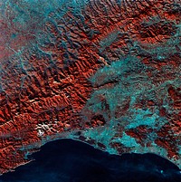
San Francisco and Bay Area, CA, USA. Original from NASA. Digitally enhanced by rawpixel. https://www.rawpixel.com/image/441579/free-photo-image-nasa-map-aerial Free Image from public domain license
China, India, and Nepal as seen from Gemini 11. Original from NASA. Digitally enhanced by rawpixel. https://www.rawpixel.com/image/441712/free-photo-image-nasa-earth-atmosphere Free Image from public domain license
Central area of Ethiopia, south of Addis Ababa, showing Lakes Zwai, Langana, and Shala. Original from NASA. Digitally… https://www.rawpixel.com/image/441749/free-photo-image-ethiopia-maps-addis-ababa Free Image from public domain license
View of the southeastern tip of the Arabian Peninsula with the Gulf of Oman at upper right. Original from NASA . Digitally… https://www.rawpixel.com/image/441702/free-photo-image-nasa-satellite-arabian Free Image from public domain license
Lying in the eastern Mediterranean Sea, the entire Island of Crete (35.0N, 25.0E) can be seen in great detail in this cloud… https://www.rawpixel.com/image/441790/free-photo-image-crete-greece-mediterranean Free Image from public domain license
Brazil and the mouth of Amazon. Original from NASA. Digitally enhanced by rawpixel. https://www.rawpixel.com/image/441707/free-photo-image-nasa-earth-atmosphere-space Free Image from public domain license
Gemini 7 view of the Middle East area. Original from NASA. Digitally enhanced by rawpixel. https://www.rawpixel.com/image/441725/free-photo-image-nasa-cosmos-middle-east Free Image from public domain license
The Gulf of California area as seen from the Gemini-12 spacecraft. Original from NASA. Digitally enhanced by rawpixel. https://www.rawpixel.com/image/441713/free-photo-image-gemini-spacecraft-earth-nasa Free Image from public domain license
Image formed by the Advanced Spaceborne Thermal Emission and Reflection Radiometer (ASTER) and Global Digital Elevation… https://www.rawpixel.com/image/441205/free-photo-image-world-map-digital Free Image from public domain license
The Wilkins Ice Shelf on the western side of the Antarctic Peninsula. Original from NASA. Digitally enhanced by rawpixel. https://www.rawpixel.com/image/441236/free-photo-image-maps-snow-advanced-spaceborne-thermal-emission-and-reflection-radiometer-aster Free Image from public domain license
This spaceborne radar image shows the area just north of the city of Cairo, Egypt, where the Nile River splits into two main… https://www.rawpixel.com/image/441541/free-photo-image-nasa-map-city-maps Free Image from public domain license
Island of Hawaii, State of Hawaii seen from Skylab. Original from NASA. Digitally enhanced by rawpixel. https://www.rawpixel.com/image/441611/free-photo-image-hawaii-volcano-island-maps Free Image from public domain license
The payload bay of the orbiting space shuttle Endeavour with an area of the Pacific Ocean northeast of Hawaii in the… https://www.rawpixel.com/image/441561/free-photo-image-aerospace-space-shuttle-astronaut Free Image from public domain license
Plankton blooms in the Falkland Current east of the Argentinian coast. Original from NASA. Digitally enhanced by rawpixel. https://www.rawpixel.com/image/441573/free-photo-image-plankton-satellite-maps Free Image from public domain license
The Rio Tinto river in southwestern Spain. Original from NASA. Digitally enhanced by rawpixel. https://www.rawpixel.com/image/441261/free-photo-image-spain-rio-tinto-satellite-climate-change Free Image from public domain license
View of Melbourne, Australia as seen from the Skylab space station. Original from NASA. Digitally enhanced by rawpixel. https://www.rawpixel.com/image/441570/free-photo-image-melbourne-australian-australia Free Image from public domain license
The magnificent natural landscape of Salzkammergut, Austria. Original from NASA . Digitally enhanced by rawpixel. https://www.rawpixel.com/image/441272/free-photo-image-topography-austria-earthquake Free Image from public domain license
View of portion of Queensland, Australia from Skylab space station. Original from NASA. Digitally enhanced by rawpixel https://www.rawpixel.com/image/441793/free-photo-image-australia-map-skylab Free Image from public domain license
Snow covered Alps of France, Italy, and Switzerland. Original from NASA. Digitally enhanced by rawpixel. https://www.rawpixel.com/image/441581/free-photo-image-nasa-switzerland-aerial Free Image from public domain license
The three main ring sail parachutes of the Skylab 3 command module as they unfurl during descent to a successful splashdown… https://www.rawpixel.com/image/418667/skylab-command-module Free Image from public domain license
Skylab 3 Earth view of the Nile Delta, Egypt and Suez Canal. Original from NASA. Digitally enhanced by rawpixel. https://www.rawpixel.com/image/439888/free-photo-image-egypt-map-nasa-ocean Free Image from public domain license
Global Digital Elevation Model. Original from NASA. Digitally enhanced by rawpixel. https://www.rawpixel.com/image/441216/free-photo-image-atlas-thermal-imaging-globe Free Image from public domain license
View of Island of Kyushu, Japan from Skylab. Original from NASA. Digitally enhanced by rawpixel. https://www.rawpixel.com/image/441794/free-photo-image-climate-change-earth-nasa-ocean Free Image from public domain license
Astronaut Jack Lousma participates in EVA to deploy twin pole solar shield. Original from NASA. Digitally enhanced by… https://www.rawpixel.com/image/441582/free-photo-image-nasa-astronaut-helmet Free Image from public domain license
Astronaut Jack R. Lousma, Skylab 3 pilot, participates in the Aug. 6, 1973, extravehicular activity. Original from NASA.… https://www.rawpixel.com/image/418664/free-photo-image-astronaut-nasa-spaceship Free Image from public domain license
The Expedition 32 crew onboard the International Space Station, flying an altitude of approximately 240 miles, recorded a… https://www.rawpixel.com/image/440248/the-international-space-station Free Image from public domain license
Orbital workshop with the area of the missing micrometeoroid shield. Original from NASA. Digitally enhanced by rawpixel. https://www.rawpixel.com/image/441799/free-photo-image-nasa-2000s-public-domain Free Image from public domain license
The Mackenzie River in the Northwest Territories, Canada. Original from NASA. Digitally enhanced by rawpixel. https://www.rawpixel.com/image/439973/map-green-terrain-canada Free Image from public domain license
Skylab 2 Farewell View from the Departing Skylab Command/Service Module. Original from NASA. Digitally enhanced by rawpixel. https://www.rawpixel.com/image/441770/free-photo-image-satellite-astronaut-solar-energy Free Image from public domain license
The Earth view from the cupola onboard the International Space Station. May 14th, 2015. Original from NASA. Digitally… https://www.rawpixel.com/image/440309/free-photo-image-nasa-window-iss Free Image from public domain license
The Zambezi, the fourth largest river in Africa, and the largest east-flowing waterway. Original from NASA. Digitally… https://www.rawpixel.com/image/440595/zambezi-river-space-view Free Image from public domain license
Akpatok Island in Ungava Bay in northern Quebec, Canada. Original from NASA. Digitally enhanced by rawpixel. https://www.rawpixel.com/image/440234/free-photo-image-water-maps-ice Free Image from public domain license
The ice of a piedmont glacier spills from a steep valley onto a relatively flat plain. Malaspina Glacier, Alaska. Original… https://www.rawpixel.com/image/440088/free-photo-image-nasa-map-piedmont Free Image from public domain license
Skylab 3, Skylab as the CM moves in for dockingOriginal from NASA. Digitally enhanced by rawpixel. https://www.rawpixel.com/image/441599/free-photo-image-satellite-apollo-skylab Free Image from public domain license
Sakhalin Island, located just north of Japan and east of the Khabarovski and Primorski Krai of the Russian Far East.… https://www.rawpixel.com/image/441164/free-photo-image-japan-maps-japanese Free Image from public domain license
Gemini 12 spacecraft seen during EVA. Original from NASA. Digitally enhanced by rawpixel. https://www.rawpixel.com/image/441750/free-photo-image-spaceship-gemini-spacecraft Free Image from public domain license
External Tank after separation from Atlantis during the STS-132 Mission. Original from NASA. Digitally enhanced by rawpixel. https://www.rawpixel.com/image/441292/free-photo-image-earth-nasa-ascending Free Image from public domain license
Acadia National Park is one of the most visited parks in America. Original from NASA. Digitally enhanced by rawpixel. https://www.rawpixel.com/image/440092/free-photo-image-map-nasa-world Free Image from public domain license
The Gemini-12 spacecraft during standup extravehicular activity with the hatch open. Original from NASA. Digitally enhanced… https://www.rawpixel.com/image/418677/the-gemini-12-spacecraft Free Image from public domain license
Artist's concept of the Skylab in orbit. Original from NASA. Digitally enhanced by rawpixel. https://www.rawpixel.com/image/441448/free-photo-image-artists-concept-astronaut-planet Free Image from public domain license
One-third of the Earth's sphere illuminated, Earth's terminator, sunglint, a portion of east Africa, as photographed from… https://www.rawpixel.com/image/1207216/moon-landing-photograph Free Image from public domain license
Astronaut Owen K. Garriott, Skylab 3 science pilot, retrieves an imagery experiment from the Apollo Telescope Mount (ATM)… https://www.rawpixel.com/image/441788/free-photo-image-nasa-space-apollo Free Image from public domain license
Images of the Earth's land surface and surrounding coastal regions. Original from NASA. Digitally enhanced by rawpixel. https://www.rawpixel.com/image/440155/free-photo-image-nasa-map-seattle Free Image from public domain license
Artist's concept of Skylab space station cluster in Earth's orbit. Original from NASA. Digitally enhanced by rawpixel. https://www.rawpixel.com/image/441775/free-photo-image-astronaut-apollo-space-station Free Image from public domain license
Astronaut participates in EVA to deploy twin polar shield. Original from NASA . Digitally enhanced by rawpixel. https://www.rawpixel.com/image/441786/free-photo-image-nasa-pilot-space Free Image from public domain license
Jamestown, located on Jamestown Island in the Virginia Colony. Original from NASA. Digitally enhanced by rawpixel. https://www.rawpixel.com/image/441199/jamestown-space-view Free Image from public domain license
Earth observations taken during STS-77 mission. Original from NASA. Digitally enhanced by rawpixel. https://www.rawpixel.com/image/441615/free-photo-image-nasa-maps-ocean Free Image from public domain license
View of Earth, showing Africa, Europe and Asia taken from the Apollo 11 spacecraft during its trans-lunar coast toward the… https://www.rawpixel.com/image/1207214/moon-landing-photograph Free Image from public domain license
Earth observations of Houston taken by STS-115 crew member. Original from NASA. Digitally enhanced by rawpixel. https://www.rawpixel.com/image/441285/free-photo-image-stadium-satellite-view-historical-maps Free Image from public domain license
The docked Russian Mir Space Station is partially visible through the Spacehab viewing port. Original from NASA. Digitally… https://www.rawpixel.com/image/441604/free-photo-image-spaceship-science-aerospace Free Image from public domain license
Earth observations of Argentina and Chile was among several of South America. Original from NASA. Digitally enhanced by… https://www.rawpixel.com/image/441601/free-photo-image-argentina-nasa-climate-change Free Image from public domain license
Thailand floods monitored by a NASA satellite. Original from NASA. Digitally enhanced by rawpixel. https://www.rawpixel.com/image/441275/free-photo-image-nasa-map-river-bank Free Image from public domain license
New image of the Earth at night is a composite assembled from data acquired by the Suomi National Polar-orbiting Partnership… https://www.rawpixel.com/image/440262/free-photo-image-map-world-background Free Image from public domain license
Image showing the International Space Station on the STS-135 mission's third day in Earth orbit. Original from NASA.… https://www.rawpixel.com/image/441349/free-photo-image-iss-satellite-spacecraft Free Image from public domain license
Image taken by a new Earth-observing instrument installed on the international space station. Original from NASA. Digitally… https://www.rawpixel.com/image/440120/free-photo-image-nasa-panama-map Free Image from public domain license
Ellesmere Island, which is part of the Qikiqtaaluk Region of the Canadian territory of Nunavut. Original from NASA.… https://www.rawpixel.com/image/440667/free-photo-image-maps-nasa-earth-map Free Image from public domain license
The Sustina Glacier in the Alaska Range. Original from NASA. Digitally enhanced by rawpixel. https://www.rawpixel.com/image/441244/free-photo-image-nasa-maps-valley Free Image from public domain license
Massive congregations of greenish phytoplankton swirl in the dark water around Gotland, a Swedish island in the Baltic Sea.… https://www.rawpixel.com/image/440200/free-photo-image-van-gogh-nasa-maps Free Image from public domain license
Agena Target Docking vehicle seen from Gemini 8 spacecraft. Original from NASA . Digitally enhanced by rawpixel. https://www.rawpixel.com/image/441557/free-photo-image-spaceship-gemini-spacecraft-docking Free Image from public domain license
Photograph of MSC-8 color patch outside spacecraft during docking. Original from NASA. Digitally enhanced by rawpixel. https://www.rawpixel.com/image/441719/msc-8-color-patch Free Image from public domain license
Composite assembled from data acquired by the Suomi National Polar-orbiting Partnership satellite over nine days in April… https://www.rawpixel.com/image/440178/map-lights-night-from-nasa Free Image from public domain license
The Gemini-Titan 7 (GT-7) spacecraft. Original from NASA. Digitally enhanced by rawpixel. https://www.rawpixel.com/image/441700/free-photo-image-spaceship-spacecraft-space Free Image from public domain license
Heilongjiang, a province of China located in the northeastern part of the country. Original from NASA. Digitally enhanced by… https://www.rawpixel.com/image/440587/heilongjiang-province-space-view Free Image from public domain license
The Channel Tunnel, a 50.5 km-long rail tunnel beneath the English Channel at the Straits of Dover. Original from NASA.… https://www.rawpixel.com/image/441134/channel-tunnel-space-view Free Image from public domain license
A close-up view of the surgical band saw, a surgical tool in the therapeutic kit of the Inflight Medical Support System… https://www.rawpixel.com/image/441564/free-photo-image-kit-photography-support Free Image from public domain license
Parts of he Kimberley region of Western Australia. Original from NASA. Digitally enhanced by rawpixel. https://www.rawpixel.com/image/440627/free-photo-image-australia-map-nasa Free Image from public domain license
Guinea-Bissau, a small country in West Africa. Original from NASA. Digitally enhanced by rawpixel. https://www.rawpixel.com/image/418619/guinea-bissau Free Image from public domain license
Earth observations taken from Space Shuttle Columbia during STS-93 mission. Original from NASA. Digitally enhanced by… https://www.rawpixel.com/image/441583/free-photo-image-fire-rainforest-climate-change Free Image from public domain license
Image acquired by NASA's Terra spacecraft of the Sierra Leone estuary. Original from NASA. Digitally enhanced by rawpixel. https://www.rawpixel.com/image/418644/sierra-leone-estuary-space-view Free Image from public domain license
Delhi, the second largest metropolis in India, with a population of 16 million. Original from NASA. Digitally enhanced by… https://www.rawpixel.com/image/441145/free-photo-image-map-satellite-maps-public-domain-high-resolution-landscape Free Image from public domain license
Flood waters in Bangkok as the Ayutthaya River overflowed its banks. Original from NASA. Digitally enhanced by rawpixel. https://www.rawpixel.com/image/440502/free-photo-image-maps-background-flood Free Image from public domain license
Aaland archipelago at the mouth of the Gulf of Bothnia which belongs to Finland. Original from NASA. Digitally enhanced by… https://www.rawpixel.com/image/441242/free-photo-image-nasa-nasa-earth-helsinki Free Image from public domain license
Brasilia, the capital of Brazil. Original from NASA. Digitally enhanced by rawpixel. https://www.rawpixel.com/image/441221/free-photo-image-brazil-brasilia-city-map Free Image from public domain license
The Musandam Peninsula, part of Oman. Original from NASA. Digitally enhanced by rawpixel. https://www.rawpixel.com/image/441188/free-photo-image-map-nasa-earth-landscape Free Image from public domain license
Guangxi Province in southeast China. Original from NASA. Digitally enhanced by rawpixel. https://www.rawpixel.com/image/440654/guangxi-provine-space-view Free Image from public domain license
Flooding from the Chao Phraya River, Thailand on Nov. 1, 2011. Original from NASA. Digitally enhanced by rawpixel. https://www.rawpixel.com/image/440508/free-photo-image-nasa-map-thailand Free Image from public domain license
Image from NASA's Terra spacecraft of Franz Josef Land, an archipelago in the far north of Russia. Original from NASA.… https://www.rawpixel.com/image/441324/free-photo-image-maps-nasa-russia Free Image from public domain license
The flooding from the Chao Phraya River, Thailand on Nov. 17, 2011. Original from NASA. Digitally enhanced by rawpixel. https://www.rawpixel.com/image/440511/free-photo-image-nasa-background-2011 Free Image from public domain license
View of the Himalaya Mountain Range in the India-Nepal-Tibet border area. Original from NASA. Digitally enhanced by rawpixel. https://www.rawpixel.com/image/441723/free-photo-image-india-maps-mountain Free Image from public domain license
Santo Domingo, the capital of the Dominican Republic. Original from NASA. Digitally enhanced by rawpixel. https://www.rawpixel.com/image/440567/free-photo-image-dominican-republic-christopher-columbus Free Image from public domain license
The northernmost land in the world is located in Pearyland, Greenland. Original from NASA. Digitally enhanced by rawpixel. https://www.rawpixel.com/image/441198/free-photo-image-nasa-snow-greenland-nature Free Image from public domain license
NASA satellite tracks underwater volcanic eruption in Canary Islands. Original from NASA. Digitally enhanced by rawpixel. https://www.rawpixel.com/image/441274/free-photo-image-ocean-underwater-climate-change Free Image from public domain license
Lake Torrens and the Australian Outback. Original from NASA. Digitally enhanced by rawpixel. https://www.rawpixel.com/image/441174/free-photo-image-australia-nasa-desert Free Image from public domain license
The city of Sukkur, Pakistan. Original from NASA. Digitally enhanced by rawpixel. https://www.rawpixel.com/image/441254/free-photo-image-flood-maps-august-2010 Free Image from public domain license
The Olympic National Park has to be one of America’s most diverse national park landscapes. Original from NASA.… https://www.rawpixel.com/image/440091/free-photo-image-satellite-nasa-olympic-national-park Free Image from public domain license
The central coastal area of Peru as seen from the Gemini-9A spacecraft. Original from NASA. Digitally enhanced by rawpixel https://www.rawpixel.com/image/441726/free-photo-image-peru-maps-satellite Free Image from public domain license
Full Mir over New Zealand, from the space shuttle Atlantis, Russia's Mir Space Station. Original from NASA. Digitally… https://www.rawpixel.com/image/441571/free-photo-image-new-zealand-maps-satellite-public-domain Free Image from public domain license
The Skylab 4/Saturn 1B space vehicle is launched from Pad B, Launch Complex 39, Kennedy Space Center, Florida, Nov. 16… https://www.rawpixel.com/image/441600/free-photo-image-rocket-skylab-florida Free Image from public domain license
Los Angeles and vicinity seen from space on May 4, 2001. Original from NASA. Digitally enhanced by rawpixel. https://www.rawpixel.com/image/440540/free-photo-image-topography-los-angeles-map-radar Free Image from public domain license
MODIS on the Aqua satellite captured this stunning view of Japans four largest islands on February 20, 2004. Original from… https://www.rawpixel.com/image/440157/free-photo-image-maps-satellite-public-domain Free Image from public domain license
Grand Turk Island is an island in the Turks and Caicos Islands in the Caribbean, and contains the territory's capital… https://www.rawpixel.com/image/441237/free-photo-image-nasa-2001-maps Free Image from public domain license
Nearly cloud-free view of Great Britain and Ireland was acquired by the Moderate Resolution Imaging Spectroradiometer aboard… https://www.rawpixel.com/image/440141/great-britain-space-view Free Image from public domain license