![Thailand floods monitored by a NASA satellite. Original from NASA. Digitally enhanced by rawpixel.]() Thailand floods monitored by a NASA satellite. Original from NASA. Digitally enhanced by rawpixel.
Thailand floods monitored by a NASA satellite. Original from NASA. Digitally enhanced by rawpixel.![Sakhalin Island, located just north of Japan and east of the Khabarovski and Primorski Krai of the Russian Far East.…]() Sakhalin Island, located just north of Japan and east of the Khabarovski and Primorski Krai of the Russian Far East.…
Sakhalin Island, located just north of Japan and east of the Khabarovski and Primorski Krai of the Russian Far East.…![The Zambezi, the fourth largest river in Africa, and the largest east-flowing waterway. Original from NASA. Digitally…]() The Zambezi, the fourth largest river in Africa, and the largest east-flowing waterway. Original from NASA. Digitally…
The Zambezi, the fourth largest river in Africa, and the largest east-flowing waterway. Original from NASA. Digitally…![Heilongjiang, a province of China located in the northeastern part of the country. Original from NASA. Digitally enhanced by…]() Heilongjiang, a province of China located in the northeastern part of the country. Original from NASA. Digitally enhanced by…
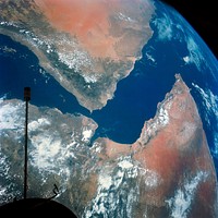
Heilongjiang, a province of China located in the northeastern part of the country. Original from NASA. Digitally enhanced by…![Earth observations taken from Space Shuttle Columbia during STS-93 mission. Original from NASA. Digitally enhanced by…]() Earth observations taken from Space Shuttle Columbia during STS-93 mission. Original from NASA. Digitally enhanced by…
Earth observations taken from Space Shuttle Columbia during STS-93 mission. Original from NASA. Digitally enhanced by…![View of the Himalaya Mountain Range in the India-Nepal-Tibet border area. Original from NASA. Digitally enhanced by rawpixel.]() View of the Himalaya Mountain Range in the India-Nepal-Tibet border area. Original from NASA. Digitally enhanced by rawpixel.
View of the Himalaya Mountain Range in the India-Nepal-Tibet border area. Original from NASA. Digitally enhanced by rawpixel.![The central coastal area of Peru as seen from the Gemini-9A spacecraft. Original from NASA. Digitally enhanced by rawpixel]() The central coastal area of Peru as seen from the Gemini-9A spacecraft. Original from NASA. Digitally enhanced by rawpixel
The central coastal area of Peru as seen from the Gemini-9A spacecraft. Original from NASA. Digitally enhanced by rawpixel![MODIS on the Aqua satellite captured this stunning view of Japans four largest islands on February 20, 2004. Original from…]() MODIS on the Aqua satellite captured this stunning view of Japans four largest islands on February 20, 2004. Original from…
MODIS on the Aqua satellite captured this stunning view of Japans four largest islands on February 20, 2004. Original from…![NASA satellite tracks underwater volcanic eruption in Canary Islands. Original from NASA. Digitally enhanced by rawpixel.]() NASA satellite tracks underwater volcanic eruption in Canary Islands. Original from NASA. Digitally enhanced by rawpixel.
NASA satellite tracks underwater volcanic eruption in Canary Islands. Original from NASA. Digitally enhanced by rawpixel.![Los Angeles and vicinity seen from space on May 4, 2001. Original from NASA. Digitally enhanced by rawpixel.]() Los Angeles and vicinity seen from space on May 4, 2001. Original from NASA. Digitally enhanced by rawpixel.
Los Angeles and vicinity seen from space on May 4, 2001. Original from NASA. Digitally enhanced by rawpixel.![Grand Turk Island is an island in the Turks and Caicos Islands in the Caribbean, and contains the territory's capital…]() Grand Turk Island is an island in the Turks and Caicos Islands in the Caribbean, and contains the territory's capital…
Grand Turk Island is an island in the Turks and Caicos Islands in the Caribbean, and contains the territory's capital…![Plankton blooms in the Falkland Current east of the Argentinian coast. Original from NASA. Digitally enhanced by rawpixel.]() Plankton blooms in the Falkland Current east of the Argentinian coast. Original from NASA. Digitally enhanced by rawpixel.
Plankton blooms in the Falkland Current east of the Argentinian coast. Original from NASA. Digitally enhanced by rawpixel.![Full Mir over New Zealand, from the space shuttle Atlantis, Russia's Mir Space Station. Original from NASA. Digitally…]() Full Mir over New Zealand, from the space shuttle Atlantis, Russia's Mir Space Station. Original from NASA. Digitally…
Full Mir over New Zealand, from the space shuttle Atlantis, Russia's Mir Space Station. Original from NASA. Digitally…![Jamestown, located on Jamestown Island in the Virginia Colony. Original from NASA. Digitally enhanced by rawpixel.]() Jamestown, located on Jamestown Island in the Virginia Colony. Original from NASA. Digitally enhanced by rawpixel.
Jamestown, located on Jamestown Island in the Virginia Colony. Original from NASA. Digitally enhanced by rawpixel.![The Republic of Singapore, a city-state off the southern tip of the Malay Peninsula. Original from NASA. Digitally enhanced…]() The Republic of Singapore, a city-state off the southern tip of the Malay Peninsula. Original from NASA. Digitally enhanced…
The Republic of Singapore, a city-state off the southern tip of the Malay Peninsula. Original from NASA. Digitally enhanced…![View of Florence, Italy area from the Skylab. Original from NASA. Digitally enhanced by rawpixel.]() View of Florence, Italy area from the Skylab. Original from NASA. Digitally enhanced by rawpixel.
View of Florence, Italy area from the Skylab. Original from NASA. Digitally enhanced by rawpixel.![New image of the Earth at night is a composite assembled from data acquired by the Suomi National Polar-orbiting Partnership…]() New image of the Earth at night is a composite assembled from data acquired by the Suomi National Polar-orbiting Partnership…
New image of the Earth at night is a composite assembled from data acquired by the Suomi National Polar-orbiting Partnership…![Kamchatka Peninsula, Russia. Original from NASA. Digitally enhanced by rawpixel.]() Kamchatka Peninsula, Russia. Original from NASA. Digitally enhanced by rawpixel.
Kamchatka Peninsula, Russia. Original from NASA. Digitally enhanced by rawpixel.![NASA’s Operation IceBridge Completes Twin Polar Campaigns. Heimdal Glacier in southern Greenland. Original from NASA.…]() NASA’s Operation IceBridge Completes Twin Polar Campaigns. Heimdal Glacier in southern Greenland. Original from NASA.…
NASA’s Operation IceBridge Completes Twin Polar Campaigns. Heimdal Glacier in southern Greenland. Original from NASA.…![Earth observations taken during STS-77 mission. Original from NASA. Digitally enhanced by rawpixel.]() Earth observations taken during STS-77 mission. Original from NASA. Digitally enhanced by rawpixel.
Earth observations taken during STS-77 mission. Original from NASA. Digitally enhanced by rawpixel.![Remote sensing of ocean color in the Yellow Sea. Original from NASA. Digitally enhanced by rawpixel.]() Remote sensing of ocean color in the Yellow Sea. Original from NASA. Digitally enhanced by rawpixel.
Remote sensing of ocean color in the Yellow Sea. Original from NASA. Digitally enhanced by rawpixel.![Sediment Transforms Lake Michigan, Original from NASA. Digitally enhanced by rawpixel.]() Sediment Transforms Lake Michigan, Original from NASA. Digitally enhanced by rawpixel.
Sediment Transforms Lake Michigan, Original from NASA. Digitally enhanced by rawpixel.![The Ouachita Mountains in southeast Oklahoma. Original from NASA. Digitally enhanced by rawpixel.]() The Ouachita Mountains in southeast Oklahoma. Original from NASA. Digitally enhanced by rawpixel.
The Ouachita Mountains in southeast Oklahoma. Original from NASA. Digitally enhanced by rawpixel.![View of Melbourne, Australia as seen from the Skylab space station. Original from NASA. Digitally enhanced by rawpixel.]() View of Melbourne, Australia as seen from the Skylab space station. Original from NASA. Digitally enhanced by rawpixel.
View of Melbourne, Australia as seen from the Skylab space station. Original from NASA. Digitally enhanced by rawpixel.![View of the northern Antarctic Peninsula from high altitude during IceBridge's flight back from the Foundation Ice Stream…]() View of the northern Antarctic Peninsula from high altitude during IceBridge's flight back from the Foundation Ice Stream…
View of the northern Antarctic Peninsula from high altitude during IceBridge's flight back from the Foundation Ice Stream…![The Olympic National Park has to be one of America’s most diverse national park landscapes. Original from NASA.…]() The Olympic National Park has to be one of America’s most diverse national park landscapes. Original from NASA.…
The Olympic National Park has to be one of America’s most diverse national park landscapes. Original from NASA.…![Acadia National Park is one of the most visited parks in America. Original from NASA. Digitally enhanced by rawpixel.]() Acadia National Park is one of the most visited parks in America. Original from NASA. Digitally enhanced by rawpixel.
Acadia National Park is one of the most visited parks in America. Original from NASA. Digitally enhanced by rawpixel.![The ice of a piedmont glacier spills from a steep valley onto a relatively flat plain. Malaspina Glacier, Alaska. Original…]() The ice of a piedmont glacier spills from a steep valley onto a relatively flat plain. Malaspina Glacier, Alaska. Original…
The ice of a piedmont glacier spills from a steep valley onto a relatively flat plain. Malaspina Glacier, Alaska. Original…![Akpatok Island in Ungava Bay in northern Quebec, Canada. Original from NASA. Digitally enhanced by rawpixel.]() Akpatok Island in Ungava Bay in northern Quebec, Canada. Original from NASA. Digitally enhanced by rawpixel.
Akpatok Island in Ungava Bay in northern Quebec, Canada. Original from NASA. Digitally enhanced by rawpixel.![Earth observations of Houston taken by STS-115 crew member. Original from NASA. Digitally enhanced by rawpixel.]() Earth observations of Houston taken by STS-115 crew member. Original from NASA. Digitally enhanced by rawpixel.
Earth observations of Houston taken by STS-115 crew member. Original from NASA. Digitally enhanced by rawpixel.![Phytoplankton bloom off Newfoundland. Original from NASA. Digitally enhanced by rawpixel.]() Phytoplankton bloom off Newfoundland. Original from NASA. Digitally enhanced by rawpixel.
Phytoplankton bloom off Newfoundland. Original from NASA. Digitally enhanced by rawpixel.![The Mackenzie River in the Northwest Territories, Canada. Original from NASA. Digitally enhanced by rawpixel.]() The Mackenzie River in the Northwest Territories, Canada. Original from NASA. Digitally enhanced by rawpixel.
The Mackenzie River in the Northwest Territories, Canada. Original from NASA. Digitally enhanced by rawpixel.![An iceberg embedded in sea ice as seen from the IceBridge DC-8 over the Bellingshausen Sea on Oct. 19, 2012. Original from…]() An iceberg embedded in sea ice as seen from the IceBridge DC-8 over the Bellingshausen Sea on Oct. 19, 2012. Original from…
An iceberg embedded in sea ice as seen from the IceBridge DC-8 over the Bellingshausen Sea on Oct. 19, 2012. Original from…![Earth observations of Argentina and Chile was among several of South America. Original from NASA. Digitally enhanced by…]() Earth observations of Argentina and Chile was among several of South America. Original from NASA. Digitally enhanced by…
Earth observations of Argentina and Chile was among several of South America. Original from NASA. Digitally enhanced by…![Southwestern US, with Las Vegas, NV in foreground, June 27, 1965. Original from NASA. Digitally enhanced by rawpixel.]() Southwestern US, with Las Vegas, NV in foreground, June 27, 1965. Original from NASA. Digitally enhanced by rawpixel.
Southwestern US, with Las Vegas, NV in foreground, June 27, 1965. Original from NASA. Digitally enhanced by rawpixel.![NASA image acquired August 17, 2010, the Northwest Passage almost free of ice. Original from NASA. Digitally enhanced by…]() NASA image acquired August 17, 2010, the Northwest Passage almost free of ice. Original from NASA. Digitally enhanced by…
NASA image acquired August 17, 2010, the Northwest Passage almost free of ice. Original from NASA. Digitally enhanced by…![The Larsen Ice Shelf in Antarctica viewed from NASA's DC-8 aircraft during the AirSAR 2004 campaign . Original from NASA.…]() The Larsen Ice Shelf in Antarctica viewed from NASA's DC-8 aircraft during the AirSAR 2004 campaign . Original from NASA.…
The Larsen Ice Shelf in Antarctica viewed from NASA's DC-8 aircraft during the AirSAR 2004 campaign . Original from NASA.…![Early Melt on the Greenland Ice Sheet . Original from NASA . Digitally enhanced by rawpixel.]() Early Melt on the Greenland Ice Sheet . Original from NASA . Digitally enhanced by rawpixel.
Early Melt on the Greenland Ice Sheet . Original from NASA . Digitally enhanced by rawpixel.![Hurricane Matthew. This is a visible image of Major Hurricane Matthew taken from NASA's Terra satellite on Oct. 7 at 12 p.m.…]() Hurricane Matthew. This is a visible image of Major Hurricane Matthew taken from NASA's Terra satellite on Oct. 7 at 12 p.m.…
Hurricane Matthew. This is a visible image of Major Hurricane Matthew taken from NASA's Terra satellite on Oct. 7 at 12 p.m.…![Massive congregations of greenish phytoplankton swirl in the dark water around Gotland, a Swedish island in the Baltic Sea.…]() Massive congregations of greenish phytoplankton swirl in the dark water around Gotland, a Swedish island in the Baltic Sea.…
Massive congregations of greenish phytoplankton swirl in the dark water around Gotland, a Swedish island in the Baltic Sea.…![Oslo, the capital and largest city in Norway. Original from NASA. Digitally enhanced by rawpixel.]() Oslo, the capital and largest city in Norway. Original from NASA. Digitally enhanced by rawpixel.
Oslo, the capital and largest city in Norway. Original from NASA. Digitally enhanced by rawpixel.![Image formed by the Advanced Spaceborne Thermal Emission and Reflection Radiometer (ASTER) and Global Digital Elevation…]() Image formed by the Advanced Spaceborne Thermal Emission and Reflection Radiometer (ASTER) and Global Digital Elevation…
Image formed by the Advanced Spaceborne Thermal Emission and Reflection Radiometer (ASTER) and Global Digital Elevation…![The Matusevich Glacier flows toward the coast of East Antarctica, pushing through a channel between the Lazarev Mountains…]() The Matusevich Glacier flows toward the coast of East Antarctica, pushing through a channel between the Lazarev Mountains…
The Matusevich Glacier flows toward the coast of East Antarctica, pushing through a channel between the Lazarev Mountains…![Oriente Province, eastern end of Cuba, as seen from the National Aeronautics and Space Administration's Gemini-7 spacecraft.…]() Oriente Province, eastern end of Cuba, as seen from the National Aeronautics and Space Administration's Gemini-7 spacecraft.…
Oriente Province, eastern end of Cuba, as seen from the National Aeronautics and Space Administration's Gemini-7 spacecraft.…![The Lena River, some 2,800 miles long, is one of the largest rivers in the world. Original from NASA. Digitally enhanced by…]() The Lena River, some 2,800 miles long, is one of the largest rivers in the world. Original from NASA. Digitally enhanced by…
The Lena River, some 2,800 miles long, is one of the largest rivers in the world. Original from NASA. Digitally enhanced by…![NASA's Terra spacecraft captured this image of the city of Arkhangelsk and administrative capital of Archangelsk Oblast…]() NASA's Terra spacecraft captured this image of the city of Arkhangelsk and administrative capital of Archangelsk Oblast…
NASA's Terra spacecraft captured this image of the city of Arkhangelsk and administrative capital of Archangelsk Oblast…![The city of Sukkur, Pakistan. Original from NASA. Digitally enhanced by rawpixel.]() The city of Sukkur, Pakistan. Original from NASA. Digitally enhanced by rawpixel.
The city of Sukkur, Pakistan. Original from NASA. Digitally enhanced by rawpixel.![Lake Mackay, the largest of hundreds of ephemeral lakes scattered throughout Western Australia and the Northern Territory.…]() Lake Mackay, the largest of hundreds of ephemeral lakes scattered throughout Western Australia and the Northern Territory.…
Lake Mackay, the largest of hundreds of ephemeral lakes scattered throughout Western Australia and the Northern Territory.…![India and Ceylon as seen from the orbiting Gemini-11 spacecraft. Original from NASA. Digitally enhanced by rawpixel.]() India and Ceylon as seen from the orbiting Gemini-11 spacecraft. Original from NASA. Digitally enhanced by rawpixel.
India and Ceylon as seen from the orbiting Gemini-11 spacecraft. Original from NASA. Digitally enhanced by rawpixel.![The Rub' al Khali, one of the largest sand deserts in the world, encompassing most of the southern third of the Arabian…]() The Rub' al Khali, one of the largest sand deserts in the world, encompassing most of the southern third of the Arabian…
The Rub' al Khali, one of the largest sand deserts in the world, encompassing most of the southern third of the Arabian…![View of a portion of Great Britain looking northeastward. Original from NASA. Digitally enhanced by rawpixel.]() View of a portion of Great Britain looking northeastward. Original from NASA. Digitally enhanced by rawpixel.
View of a portion of Great Britain looking northeastward. Original from NASA. Digitally enhanced by rawpixel.![View of Island of Kyushu, Japan from Skylab. Original from NASA. Digitally enhanced by rawpixel.]() View of Island of Kyushu, Japan from Skylab. Original from NASA. Digitally enhanced by rawpixel.
View of Island of Kyushu, Japan from Skylab. Original from NASA. Digitally enhanced by rawpixel.![Gemini Titan GT-11 photo of earth sky. Original from NASA. Digitally enhanced by rawpixel.]() Gemini Titan GT-11 photo of earth sky. Original from NASA. Digitally enhanced by rawpixel.
Gemini Titan GT-11 photo of earth sky. Original from NASA. Digitally enhanced by rawpixel.![Western half of Australia, including the coastline from Perth to Port Darwin, looking west. Original from NASA. Digitally…]() Western half of Australia, including the coastline from Perth to Port Darwin, looking west. Original from NASA. Digitally…
Western half of Australia, including the coastline from Perth to Port Darwin, looking west. Original from NASA. Digitally…![NASA Shuttle Radar Topography Mission imaged Sendai, the capital city of Japan Miyagi Prefecture a magnitude 8.9 earthquake…]() NASA Shuttle Radar Topography Mission imaged Sendai, the capital city of Japan Miyagi Prefecture a magnitude 8.9 earthquake…
NASA Shuttle Radar Topography Mission imaged Sendai, the capital city of Japan Miyagi Prefecture a magnitude 8.9 earthquake…![Artist Concept: Active Black Hole Squashes Star Formation. Original from NASA. Digitally enhanced by rawpixel.]() Artist Concept: Active Black Hole Squashes Star Formation. Original from NASA. Digitally enhanced by rawpixel.
Artist Concept: Active Black Hole Squashes Star Formation. Original from NASA. Digitally enhanced by rawpixel.![Composite of 30 Doradus, the Tarantula Nebula, contains data from Chandra (blue), Hubble (green), and Spitzer (red).…]() Composite of 30 Doradus, the Tarantula Nebula, contains data from Chandra (blue), Hubble (green), and Spitzer (red).…
Composite of 30 Doradus, the Tarantula Nebula, contains data from Chandra (blue), Hubble (green), and Spitzer (red).…![Artist’s concept of the Orbiting Carbon Observatory. Original from NASA. Digitally enhanced by rawpixel.]() Artist’s concept of the Orbiting Carbon Observatory. Original from NASA. Digitally enhanced by rawpixel.
Artist’s concept of the Orbiting Carbon Observatory. Original from NASA. Digitally enhanced by rawpixel.![China, India, and Nepal as seen from Gemini 11. Original from NASA. Digitally enhanced by rawpixel.]() China, India, and Nepal as seen from Gemini 11. Original from NASA. Digitally enhanced by rawpixel.
China, India, and Nepal as seen from Gemini 11. Original from NASA. Digitally enhanced by rawpixel.![Mackenzie Bay, Antarctica and the ice shelf on February 12, 2012., Original from NASA. Digitally enhanced by rawpixel.]() Mackenzie Bay, Antarctica and the ice shelf on February 12, 2012., Original from NASA. Digitally enhanced by rawpixel.
Mackenzie Bay, Antarctica and the ice shelf on February 12, 2012., Original from NASA. Digitally enhanced by rawpixel.![Skylab 2 Farewell View from the Departing Skylab Command/Service Module. Original from NASA. Digitally enhanced by rawpixel.]() Skylab 2 Farewell View from the Departing Skylab Command/Service Module. Original from NASA. Digitally enhanced by rawpixel.
Skylab 2 Farewell View from the Departing Skylab Command/Service Module. Original from NASA. Digitally enhanced by rawpixel.![A Nearby Stellar Cradle. Original from NASA. Digitally enhanced by rawpixel.]() A Nearby Stellar Cradle. Original from NASA. Digitally enhanced by rawpixel.
A Nearby Stellar Cradle. Original from NASA. Digitally enhanced by rawpixel.![Guinea-Bissau, a small country in West Africa. Original from NASA. Digitally enhanced by rawpixel.]() Guinea-Bissau, a small country in West Africa. Original from NASA. Digitally enhanced by rawpixel.
Guinea-Bissau, a small country in West Africa. Original from NASA. Digitally enhanced by rawpixel.![The Rio Tinto river in southwestern Spain. Original from NASA. Digitally enhanced by rawpixel.]() The Rio Tinto river in southwestern Spain. Original from NASA. Digitally enhanced by rawpixel.
The Rio Tinto river in southwestern Spain. Original from NASA. Digitally enhanced by rawpixel.![Clear shot of every parcel of Earth’s land surface and islands in nighttime view in visible light. A composite of…]() Clear shot of every parcel of Earth’s land surface and islands in nighttime view in visible light. A composite of…
Clear shot of every parcel of Earth’s land surface and islands in nighttime view in visible light. A composite of…![The magnificent natural landscape of Salzkammergut, Austria. Original from NASA . Digitally enhanced by rawpixel.]() The magnificent natural landscape of Salzkammergut, Austria. Original from NASA . Digitally enhanced by rawpixel.
The magnificent natural landscape of Salzkammergut, Austria. Original from NASA . Digitally enhanced by rawpixel.![Typhoon Phanfone affecting Japan, on October 5, 2014. Original from NASA. Digitally enhanced by rawpixel.]() Typhoon Phanfone affecting Japan, on October 5, 2014. Original from NASA. Digitally enhanced by rawpixel.
Typhoon Phanfone affecting Japan, on October 5, 2014. Original from NASA. Digitally enhanced by rawpixel.![View of a cloudy earth shown from space. This particular image portrays the average of all of the satellite's cloud…]() View of a cloudy earth shown from space. This particular image portrays the average of all of the satellite's cloud…
View of a cloudy earth shown from space. This particular image portrays the average of all of the satellite's cloud…![Ribbons of Saharan sand dunes seem to glow in sunset colors. Original from NASA. Digitally enhanced by rawpixel.]() Ribbons of Saharan sand dunes seem to glow in sunset colors. Original from NASA. Digitally enhanced by rawpixel.
Ribbons of Saharan sand dunes seem to glow in sunset colors. Original from NASA. Digitally enhanced by rawpixel.![The eastern hemisphere was captured on March 30, 2014, by the Visible Infrared Imaging Radiometer Suite on the Suomi NPP…]() The eastern hemisphere was captured on March 30, 2014, by the Visible Infrared Imaging Radiometer Suite on the Suomi NPP…
The eastern hemisphere was captured on March 30, 2014, by the Visible Infrared Imaging Radiometer Suite on the Suomi NPP…![A perfect sunset over NASA's Kennedy Space Center in Florida. Original from NASA. Digitally enhanced by rawpixel.]() A perfect sunset over NASA's Kennedy Space Center in Florida. Original from NASA. Digitally enhanced by rawpixel.
A perfect sunset over NASA's Kennedy Space Center in Florida. Original from NASA. Digitally enhanced by rawpixel.![Astronaut Edwin E. Aldrin Jr., pilot of the Gemini-12 spaceflight, performs extravehicular activity. Original from NASA.…]() Astronaut Edwin E. Aldrin Jr., pilot of the Gemini-12 spaceflight, performs extravehicular activity. Original from NASA.…
Astronaut Edwin E. Aldrin Jr., pilot of the Gemini-12 spaceflight, performs extravehicular activity. Original from NASA.…![NASA-NOAA's Suomi NPP Satellite Gets Colorful Look at Hurricane Blanca. Original from NASA. Digitally enhanced by rawpixel.]() NASA-NOAA's Suomi NPP Satellite Gets Colorful Look at Hurricane Blanca. Original from NASA. Digitally enhanced by rawpixel.
NASA-NOAA's Suomi NPP Satellite Gets Colorful Look at Hurricane Blanca. Original from NASA. Digitally enhanced by rawpixel.![Pyroclastic Flow Remnants at Shiveluch Volcano. Original from NASA. Digitally enhanced by rawpixel.]() Pyroclastic Flow Remnants at Shiveluch Volcano. Original from NASA. Digitally enhanced by rawpixel.
Pyroclastic Flow Remnants at Shiveluch Volcano. Original from NASA. Digitally enhanced by rawpixel.![A perfect sunset over NASA's Kennedy Space Center in Florida. Original from NASA. Digitally enhanced by rawpixel.]() A perfect sunset over NASA's Kennedy Space Center in Florida. Original from NASA. Digitally enhanced by rawpixel.
A perfect sunset over NASA's Kennedy Space Center in Florida. Original from NASA. Digitally enhanced by rawpixel.![A perfect sunset over NASA's Kennedy Space Center in Florida. Original from NASA. Digitally enhanced by rawpixel.]() A perfect sunset over NASA's Kennedy Space Center in Florida. Original from NASA. Digitally enhanced by rawpixel.
A perfect sunset over NASA's Kennedy Space Center in Florida. Original from NASA. Digitally enhanced by rawpixel.![On August 22, 2014 the Moderate Resolution Imaging Spectroradiometer aboard NASA’s Terra satellite captured a true…]() On August 22, 2014 the Moderate Resolution Imaging Spectroradiometer aboard NASA’s Terra satellite captured a true…
On August 22, 2014 the Moderate Resolution Imaging Spectroradiometer aboard NASA’s Terra satellite captured a true…![Hurricane Gonzalo's northern quadrant over Bermuda. Original from NASA. Digitally enhanced by rawpixel.]() Hurricane Gonzalo's northern quadrant over Bermuda. Original from NASA. Digitally enhanced by rawpixel.
Hurricane Gonzalo's northern quadrant over Bermuda. Original from NASA. Digitally enhanced by rawpixel.![The first pass of Echo 1, America's first communications satellite, over the Goldstone Tracking Station in Pasadena…]() The first pass of Echo 1, America's first communications satellite, over the Goldstone Tracking Station in Pasadena…
The first pass of Echo 1, America's first communications satellite, over the Goldstone Tracking Station in Pasadena…![OES-13 Satellite Sees a Giant Apostrophe from Strong Eastern U.S. Low Pressure. Original from NASA . Digitally enhanced by…]() OES-13 Satellite Sees a Giant Apostrophe from Strong Eastern U.S. Low Pressure. Original from NASA . Digitally enhanced by…
OES-13 Satellite Sees a Giant Apostrophe from Strong Eastern U.S. Low Pressure. Original from NASA . Digitally enhanced by…![The city of Chateaubriant, France. Original from NASA. Digitally enhanced by rawpixel.]() The city of Chateaubriant, France. Original from NASA. Digitally enhanced by rawpixel.
The city of Chateaubriant, France. Original from NASA. Digitally enhanced by rawpixel.![Parts of the vast Ganges delta. Original from NASA. Digitally enhanced by rawpixel.]() Parts of the vast Ganges delta. Original from NASA. Digitally enhanced by rawpixel.
Parts of the vast Ganges delta. Original from NASA. Digitally enhanced by rawpixel.![The Jizzax Province in eastern Uzbekistan. Original from NASA. Digitally enhanced by rawpixel.]() The Jizzax Province in eastern Uzbekistan. Original from NASA. Digitally enhanced by rawpixel.
The Jizzax Province in eastern Uzbekistan. Original from NASA. Digitally enhanced by rawpixel.![Nunavut, in northern Canada, the largest and newest federal territory of the country. Original from NASA. Digitally enhanced…]() Nunavut, in northern Canada, the largest and newest federal territory of the country. Original from NASA. Digitally enhanced…
Nunavut, in northern Canada, the largest and newest federal territory of the country. Original from NASA. Digitally enhanced…![The Republic of Seychelles, an island country with an archipelago of 115 islands. Original from NASA. Digitally enhanced by…]() The Republic of Seychelles, an island country with an archipelago of 115 islands. Original from NASA. Digitally enhanced by…
The Republic of Seychelles, an island country with an archipelago of 115 islands. Original from NASA. Digitally enhanced by…![Astronaut Owen K. Garriott, Skylab 3 science pilot, retrieves an imagery experiment from the Apollo Telescope Mount (ATM)…]() Astronaut Owen K. Garriott, Skylab 3 science pilot, retrieves an imagery experiment from the Apollo Telescope Mount (ATM)…
Astronaut Owen K. Garriott, Skylab 3 science pilot, retrieves an imagery experiment from the Apollo Telescope Mount (ATM)…![A NASA scientific balloon awaits launch in McMurdo, Antarctica. Original from NASA. Digitally enhanced by rawpixel.]() A NASA scientific balloon awaits launch in McMurdo, Antarctica. Original from NASA. Digitally enhanced by rawpixel.
A NASA scientific balloon awaits launch in McMurdo, Antarctica. Original from NASA. Digitally enhanced by rawpixel.![Saunders Island and Wolstenholme Fjord with Kap Atholl in the background. Original from NASA. Digitally enhanced by rawpixel.]() Saunders Island and Wolstenholme Fjord with Kap Atholl in the background. Original from NASA. Digitally enhanced by rawpixel.
Saunders Island and Wolstenholme Fjord with Kap Atholl in the background. Original from NASA. Digitally enhanced by rawpixel.![NASA Stennis Space Center visitor center and museum grows butterhead lettuce using an aeroponic process that involves no…]() NASA Stennis Space Center visitor center and museum grows butterhead lettuce using an aeroponic process that involves no…
NASA Stennis Space Center visitor center and museum grows butterhead lettuce using an aeroponic process that involves no…![Excellent stereo and side view of the Agena Target Docking Vehicle as seen from the Gemini-12 spacecraft. Original from NASA…]() Excellent stereo and side view of the Agena Target Docking Vehicle as seen from the Gemini-12 spacecraft. Original from NASA…
Excellent stereo and side view of the Agena Target Docking Vehicle as seen from the Gemini-12 spacecraft. Original from NASA…![Western half of Australia, including the coastline from Perth to Port Darwin. Original from NASA . Digitally enhanced by…]() Western half of Australia, including the coastline from Perth to Port Darwin. Original from NASA . Digitally enhanced by…
Western half of Australia, including the coastline from Perth to Port Darwin. Original from NASA . Digitally enhanced by…![Agena Target Docking Vehicle docked to Gemini-10 spacecraft. Original from NASA. Digitally enhanced by rawpixel.]() Agena Target Docking Vehicle docked to Gemini-10 spacecraft. Original from NASA. Digitally enhanced by rawpixel.
Agena Target Docking Vehicle docked to Gemini-10 spacecraft. Original from NASA. Digitally enhanced by rawpixel.![Satellite image of Earth. Original from NASA. Digitally enhanced by rawpixel.]() Satellite image of Earth. Original from NASA. Digitally enhanced by rawpixel.
Satellite image of Earth. Original from NASA. Digitally enhanced by rawpixel.![The Indonesian islands of Komodo, Rintja, Padar, and Flores in the Komodo National Park. Original from NASA. Digitally…]() The Indonesian islands of Komodo, Rintja, Padar, and Flores in the Komodo National Park. Original from NASA. Digitally…
The Indonesian islands of Komodo, Rintja, Padar, and Flores in the Komodo National Park. Original from NASA. Digitally…![Satellite image of Earth. Original from NASA. Digitally enhanced by rawpixel.]() Satellite image of Earth. Original from NASA. Digitally enhanced by rawpixel.
Satellite image of Earth. Original from NASA. Digitally enhanced by rawpixel.![Gaza Strip and the Mediterranean Sea from the Shuttle KidSat Camera. Original from NASA. Digitally enhanced by rawpixel.]() Gaza Strip and the Mediterranean Sea from the Shuttle KidSat Camera. Original from NASA. Digitally enhanced by rawpixel.
Gaza Strip and the Mediterranean Sea from the Shuttle KidSat Camera. Original from NASA. Digitally enhanced by rawpixel.![The Isle of Man. Original from NASA. Digitally enhanced by rawpixel.]() The Isle of Man. Original from NASA. Digitally enhanced by rawpixel.
The Isle of Man. Original from NASA. Digitally enhanced by rawpixel.![The McMurdo Dry Valleys are a row of valleys west of McMurdo Sound, Antarctica. They are so named because of their extremely…]() The McMurdo Dry Valleys are a row of valleys west of McMurdo Sound, Antarctica. They are so named because of their extremely…
The McMurdo Dry Valleys are a row of valleys west of McMurdo Sound, Antarctica. They are so named because of their extremely…