Before precision land leveling, this neighboring rice field has a crop of equal age, but to compensate for an elevation change, the fields are progressively lower or higher than the field next to it.
The rows of corn also need to be planted according to elevation, causing the rows to curve to stay level. Then adjacent rows need to follow those same curves or diagonal angles.
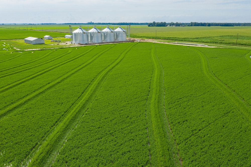
Precision land leveled fields provide a better yield for Seidenstricker Farms, for farmers Robert and Cathy Seidenstricker who for more than several years have leveled the irregularities on their on the land they own and lease, this improves surface drainage, provides for more uniform cultivation, and improve equipment operation and efficiency, in DeValls Bluff, AR, on June 25, 2019. Son Stewart Seidenstricker is the fifth generation of the family to work on the farm learning best practices such as this and integrating them with several other practices implemented on the farm.
The leveling process applies soil on areas where depressions, mounds, old terraces, turn-rows, and other surface irregularities interfere with the application of needed soil and water conservation and management practices. It is limited to areas having adequate soil depth or where topsoil can be salvaged and replaced.
The U.S. Department of Agriculture (USDA) Farm Production and Conservation (FPAC) recognizes this as a best practice. The Seidenstrickers work with Natural Resources Conservation Service (NRCS) District Conservationist Gwen Hancock, State Irrigation Engineer Charlotte Bowie, and Civil Engineering Technician Shane Harrison on their conservation plan which includes program efforts that include other portions of the irrigation system.
NRCS has a proud history of supporting America’s farmers, ranchers, and forest landowners. For more than 80 years, we have helped people make investments in their operations and local communities to keep working lands working, boost rural economies, increase the competitiveness of American agriculture, and improve the quality of our air, water, soil, and habitat.
As the USDA’s primary private lands conservation agency, we generate, manage, and share the data, technology, and standards that enable partners and policymakers to make decisions informed by objective, reliable science.
And through one-on-one, personalized advice, we work voluntarily with producers and communities to find the best solutions to meet their unique conservation and business goals. By doing so, we help ensure the health of our natural resources and the long-term sustainability of American agriculture.
FPAC is the Department’s focal point for the nation’s farmers and ranchers and other stewards of private agricultural lands and non-industrial private forest lands. Its agencies implement programs designed to mitigate the significant risks of farming through crop insurance services, conservation programs, and technical assistance, and commodity, lending, and disaster programs.
The agencies and service supporting FPAC are Farm Service Agency (FSA), Natural Resources Conservation Service (NRCS), and Risk Management Agency (RMA).
For more information please see www.usda.gov.
USDA Photo by Lance Cheung. Original public domain image from Flickr
Get Premium
Professional design resources and creative tools
- Unlimited downloads
- Ad-free experience
- Unlock millions of creative assets and our entire Creative Studio of editable templates, mockups and design tools