Or start from these designs
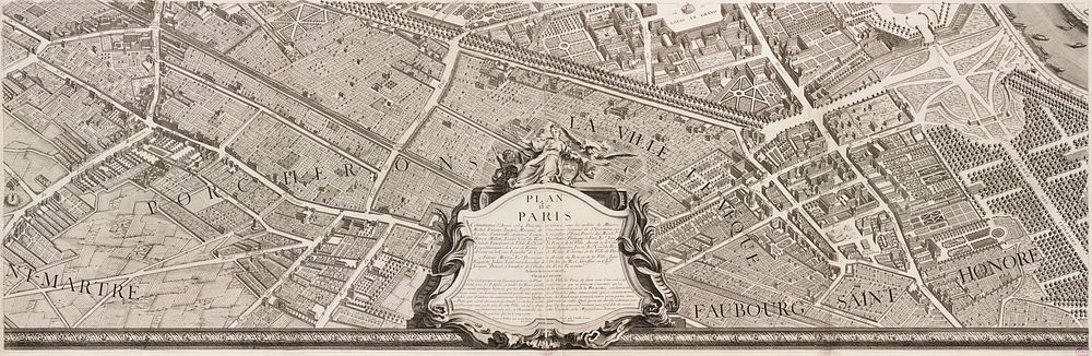
In marked contrast to the small, single-page city views appearing in late 16th and 17th century town atlases, were large, multi-sheet wall maps and birds eye views published during the 18th century. These richly detailed urban images depicted Europes largest and most important cities, such as London, Dublin, Rome, Vienna, and Paris. Displayed here is one page from a 20-sheet view of Paris, drawn from a birds eye perspective. Commissioned in 1734 by Michel Etienne Turgot, Prevot des Marchands (chief merchant or as we might say today, head of the chamber of commerce), this view was prepared by Louis Bretez, a sculptor, painter, and specialist in perspective. It took him five years to complete and publish this large-scale drawing of Frances capital city. Bretez constructed the drawing as if the city was being viewed from the northwest, looking southeast, with the Seine River running through the middle of his composition. He also places Éle de la Cité and Éle St. Louis, the historic heart of the city, near the center of the image. The twenty sheets are placed together create a dramatic wall map measuring approximately eight by ten feet. Such a presentation, as depicted in the composite reproduction displayed on the wall, captures the grandeur of the imperial city under the reign of Louis XV. Meanwhile, the exquisite detail which Bretez used to render individual buildings is evident in the atlas plate displayed below.
Original public domain image from Wikimedia Commons
Public DomainFree CC0 image for Personal and Business use
MonthlyYearlySave 50%
Get Premium
Professional design resources and creative tools
from
from
$
6.50
/mo
$78 billed yearly
- Unlimited downloads
- Ad-free experience
- Unlock millions of creative assets and our entire Creative Studio of editable templates, mockups and design tools