
Or start from these designs
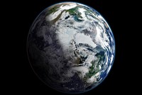
Satellite-based view of the Arctic. The images for this scene were captured on September 2, 2012, by the Visible Infrared Imaging Radiometer Suite (VIIRS) on the Suomi NPP satellite. The composite was compiled from 14 orbits of the satellite and multiple imaging channels, then stitched together to blend the edges of each satellite pass. The record lowest minimum ever observed in the satellite record occurred on September 16, 2012, when sea ice plummeted to 3.41 million square kilometers (1.32 million square miles). This image shows the area two weeks earlier. The edges of the ice pack are reasonably visible, as are some fractured areas, but some details are obscured by clouds.
Original public domain image from Wikimedia Commons
Public DomainFree CC0 image for Personal and Business use
MonthlyYearlySave 50%
Get Premium
Professional design resources and creative tools
from
from
$
6.50
/mo
$78 billed yearly
- Unlimited downloads
- Ad-free experience
- Unlock millions of creative assets and our entire Creative Studio of editable templates, mockups and design tools