![Portolan atlas of the Mediterranean Sea, western Europe, and the northwest coast of Africa: Eastern Mediterranean (ca. 1590)…]() Portolan atlas of the Mediterranean Sea, western Europe, and the northwest coast of Africa: Eastern Mediterranean (ca. 1590)…
Portolan atlas of the Mediterranean Sea, western Europe, and the northwest coast of Africa: Eastern Mediterranean (ca. 1590)…![Portolan atlas of the Mediterranean Sea, western Europe, and the northwest coast of Africa: Central Mediterranean (ca. 1590)…]() Portolan atlas of the Mediterranean Sea, western Europe, and the northwest coast of Africa: Central Mediterranean (ca. 1590)…
Portolan atlas of the Mediterranean Sea, western Europe, and the northwest coast of Africa: Central Mediterranean (ca. 1590)…![Portolan atlas of the Mediterranean Sea, western Europe, and the northwest coast of Africa (1590) by Joan Oliva]() Portolan atlas of the Mediterranean Sea, western Europe, and the northwest coast of Africa (1590) by Joan Oliva
Portolan atlas of the Mediterranean Sea, western Europe, and the northwest coast of Africa (1590) by Joan Oliva![Portolan atlas of the Mediterranean Sea, western Europe, and the northwest coast of Africa: Central Mediterranean (ca. 1590)…]() Portolan atlas of the Mediterranean Sea, western Europe, and the northwest coast of Africa: Central Mediterranean (ca. 1590)…
Portolan atlas of the Mediterranean Sea, western Europe, and the northwest coast of Africa: Central Mediterranean (ca. 1590)…![Portolan atlas of the Mediterranean Sea, western Europe, and the northwest coast of Africa (1590) by Joan Oliva]() Portolan atlas of the Mediterranean Sea, western Europe, and the northwest coast of Africa (1590) by Joan Oliva
Portolan atlas of the Mediterranean Sea, western Europe, and the northwest coast of Africa (1590) by Joan Oliva![Portolan atlas of the Mediterranean Sea, western Europe, and the northwest coast of Africa (1590) by Joan Oliva]() Portolan atlas of the Mediterranean Sea, western Europe, and the northwest coast of Africa (1590) by Joan Oliva
Portolan atlas of the Mediterranean Sea, western Europe, and the northwest coast of Africa (1590) by Joan Oliva ![Portolan atlas of the Mediterranean Sea, western Europe, and the northwest coast of Africa (1590) by Joan Oliva]() Portolan atlas of the Mediterranean Sea, western Europe, and the northwest coast of Africa (1590) by Joan Oliva
Portolan atlas of the Mediterranean Sea, western Europe, and the northwest coast of Africa (1590) by Joan Oliva![Typus orbis terrarum (1587–1595) by Abraham Ortelius. Original From The New York Public Library. Digitally enhanced by…]() Typus orbis terrarum (1587–1595) by Abraham Ortelius. Original From The New York Public Library. Digitally enhanced by…
Typus orbis terrarum (1587–1595) by Abraham Ortelius. Original From The New York Public Library. Digitally enhanced by…![Mappa totius mundi: adornata juxta observationes (1682) by Guilielmum de l'Isle. Original from The Beinecke Rare Book &…]() Mappa totius mundi: adornata juxta observationes (1682) by Guilielmum de l'Isle. Original from The Beinecke Rare Book &…
Mappa totius mundi: adornata juxta observationes (1682) by Guilielmum de l'Isle. Original from The Beinecke Rare Book &…![Vlakke aard-kloot gemeenlyk genaamd de geheele waereld (1696) by Carel Allard. Original from The Beinecke Rare Book &…]() Vlakke aard-kloot gemeenlyk genaamd de geheele waereld (1696) by Carel Allard. Original from The Beinecke Rare Book &…
Vlakke aard-kloot gemeenlyk genaamd de geheele waereld (1696) by Carel Allard. Original from The Beinecke Rare Book &…![Planiglobii terrestris mappa vniversalis (1746) by George Moritz, Johann Matthias Hase, and Homann Erben. Original from The…]() Planiglobii terrestris mappa vniversalis (1746) by George Moritz, Johann Matthias Hase, and Homann Erben. Original from The…
Planiglobii terrestris mappa vniversalis (1746) by George Moritz, Johann Matthias Hase, and Homann Erben. Original from The…![A mapp of the world (1682) by John Playford. Original From The New York Public Library. Digitally enhanced by rawpixel.]() A mapp of the world (1682) by John Playford. Original From The New York Public Library. Digitally enhanced by rawpixel.
A mapp of the world (1682) by John Playford. Original From The New York Public Library. Digitally enhanced by rawpixel.![Nova totius terrarum orbis geographica ac hydrographica (ca. 1635–1650) by Guiljelmo Blaeuw. Original from The…]() Nova totius terrarum orbis geographica ac hydrographica (ca. 1635–1650) by Guiljelmo Blaeuw. Original from The…
Nova totius terrarum orbis geographica ac hydrographica (ca. 1635–1650) by Guiljelmo Blaeuw. Original from The…![Mappa totius mundi : adornata juxta observationes dnn. academiae regalis scientiarum et nonnullorum aliorum secundum…]() Mappa totius mundi : adornata juxta observationes dnn. academiae regalis scientiarum et nonnullorum aliorum secundum…
Mappa totius mundi : adornata juxta observationes dnn. academiae regalis scientiarum et nonnullorum aliorum secundum…![Mappa mondo o vero carta generale del globo terrestre (1674) by N. Sanson de Abbeville. Original from The Beinecke Rare Book…]() Mappa mondo o vero carta generale del globo terrestre (1674) by N. Sanson de Abbeville. Original from The Beinecke Rare Book…
Mappa mondo o vero carta generale del globo terrestre (1674) by N. Sanson de Abbeville. Original from The Beinecke Rare Book…![New World, or, Western Hemisphere; Old World, or Eastern Hemisphere (1790) by William Faden. Original From The New York…]() New World, or, Western Hemisphere; Old World, or Eastern Hemisphere (1790) by William Faden. Original From The New York…
New World, or, Western Hemisphere; Old World, or Eastern Hemisphere (1790) by William Faden. Original From The New York…![Mappe Monde ou Carte générale de l'Univers (1782) by Mathieu Albert Lotter. Original from The Beinecke Rare Book &…]() Mappe Monde ou Carte générale de l'Univers (1782) by Mathieu Albert Lotter. Original from The Beinecke Rare Book &…
Mappe Monde ou Carte générale de l'Univers (1782) by Mathieu Albert Lotter. Original from The Beinecke Rare Book &…![Johnson's Western Hemisphere [and] Johnson's Eastern Hemisphere (1866) by Johnson and Ward. Original from The Beinecke Rare…]() Johnson's Western Hemisphere [and] Johnson's Eastern Hemisphere (1866) by Johnson and Ward. Original from The Beinecke Rare…
Johnson's Western Hemisphere [and] Johnson's Eastern Hemisphere (1866) by Johnson and Ward. Original from The Beinecke Rare…![Nova & accuratissima totius terrarum orbis tabula nautica variationum magneticarum index juxta observationes Anno 1700…]() Nova & accuratissima totius terrarum orbis tabula nautica variationum magneticarum index juxta observationes Anno 1700…
Nova & accuratissima totius terrarum orbis tabula nautica variationum magneticarum index juxta observationes Anno 1700…![Nova et accuratissima totius terrarum orbis tabula (ca. 1648–1664) by Joan Blaeu. Original From The New York Public…]() Nova et accuratissima totius terrarum orbis tabula (ca. 1648–1664) by Joan Blaeu. Original From The New York Public…
Nova et accuratissima totius terrarum orbis tabula (ca. 1648–1664) by Joan Blaeu. Original From The New York Public…![Nieuwe Werelt kaert (1672) by Goos Pieter. Original From The New York Public Library. Digitally enhanced by rawpixel.]() Nieuwe Werelt kaert (1672) by Goos Pieter. Original From The New York Public Library. Digitally enhanced by rawpixel.
Nieuwe Werelt kaert (1672) by Goos Pieter. Original From The New York Public Library. Digitally enhanced by rawpixel.![Map sampler made at Pleasent Valley Quaker Boarding School (1809) by Polly Platt. Original from The MET Museum. Digitally…]() Map sampler made at Pleasent Valley Quaker Boarding School (1809) by Polly Platt. Original from The MET Museum. Digitally…
Map sampler made at Pleasent Valley Quaker Boarding School (1809) by Polly Platt. Original from The MET Museum. Digitally…![Planiglobii Terrestris Mappa Universalis (1746) by Johann Baptist Homann. Original from The MET Museum. Digitally enhanced…]() Planiglobii Terrestris Mappa Universalis (1746) by Johann Baptist Homann. Original from The MET Museum. Digitally enhanced…
Planiglobii Terrestris Mappa Universalis (1746) by Johann Baptist Homann. Original from The MET Museum. Digitally enhanced…![[Chart of the Mediterranean, Black Sea, and the coasts of western Europe and northwest Africa]]() [Chart of the Mediterranean, Black Sea, and the coasts of western Europe and northwest Africa]
[Chart of the Mediterranean, Black Sea, and the coasts of western Europe and northwest Africa]![[Chart of the Mediterranean, the coast of Portugal, and the northwest coast of Africa]]() [Chart of the Mediterranean, the coast of Portugal, and the northwest coast of Africa]
[Chart of the Mediterranean, the coast of Portugal, and the northwest coast of Africa]![Nova totius terrarum orbis geographica ac hydrographica tabula (1635–1649) by Jan Aertse van den Ende. Original from…]() Nova totius terrarum orbis geographica ac hydrographica tabula (1635–1649) by Jan Aertse van den Ende. Original from…
Nova totius terrarum orbis geographica ac hydrographica tabula (1635–1649) by Jan Aertse van den Ende. Original from…![A Cyclopedia of Geography, descriptive and physical, forming a new general gazetteer of the world and dictionary of…]() A Cyclopedia of Geography, descriptive and physical, forming a new general gazetteer of the world and dictionary of…
A Cyclopedia of Geography, descriptive and physical, forming a new general gazetteer of the world and dictionary of…![Vintage globe illustration]() Vintage globe illustration
Vintage globe illustration![Hand drawn globe vintage illustration]() Hand drawn globe vintage illustration
Hand drawn globe vintage illustration![Hand drawn globe illustration]() Hand drawn globe illustration
Hand drawn globe illustration![New world or western hemisphere: old world or eastern hemisphere (1786) by William Faden. Original from The Beinecke Rare…]() New world or western hemisphere: old world or eastern hemisphere (1786) by William Faden. Original from The Beinecke Rare…
New world or western hemisphere: old world or eastern hemisphere (1786) by William Faden. Original from The Beinecke Rare…![Vlakke aard-kloot met het beide hemelsch half-rond, of de onder scheidene verbeelding van de land-water-waereld (1709) by…]() Vlakke aard-kloot met het beide hemelsch half-rond, of de onder scheidene verbeelding van de land-water-waereld (1709) by…
Vlakke aard-kloot met het beide hemelsch half-rond, of de onder scheidene verbeelding van de land-water-waereld (1709) by…![A new map of the world according to the new observations (1732) by Herman Moll. Original from The Beinecke Rare Book &…]() A new map of the world according to the new observations (1732) by Herman Moll. Original from The Beinecke Rare Book &…
A new map of the world according to the new observations (1732) by Herman Moll. Original from The Beinecke Rare Book &…![Description generale du globe terrestre et aquatique en deux-plans-hemispheres (1691) by Alexis-Hubert Jaillot and Nicolas…]() Description generale du globe terrestre et aquatique en deux-plans-hemispheres (1691) by Alexis-Hubert Jaillot and Nicolas…
Description generale du globe terrestre et aquatique en deux-plans-hemispheres (1691) by Alexis-Hubert Jaillot and Nicolas…![A Map of the World from the best Authorities (1795) from Carey's American Edition of Guthrie's Geography Improved. Original…]() A Map of the World from the best Authorities (1795) from Carey's American Edition of Guthrie's Geography Improved. Original…
A Map of the World from the best Authorities (1795) from Carey's American Edition of Guthrie's Geography Improved. Original…![Globe collage element, hand drawn vintage illustration psd]() Globe collage element, hand drawn vintage illustration psd
Globe collage element, hand drawn vintage illustration psd![Globe collage element, hand drawn vintage illustration psd]() Globe collage element, hand drawn vintage illustration psd
Globe collage element, hand drawn vintage illustration psd![Hand drawn collage element, vintage illustration psd]() Hand drawn collage element, vintage illustration psd
Hand drawn collage element, vintage illustration psd![Colton's Map of the World on Mercator's Projection (1858) by J.H. Colton & Co. Original from The Beinecke Rare Book &…]() Colton's Map of the World on Mercator's Projection (1858) by J.H. Colton & Co. Original from The Beinecke Rare Book &…
Colton's Map of the World on Mercator's Projection (1858) by J.H. Colton & Co. Original from The Beinecke Rare Book &…![Die Erde. Eine allgemeine Erd- und Länderkunde, etc (1896) by Franz Heiderich. Original from British Library. Digitally…]() Die Erde. Eine allgemeine Erd- und Länderkunde, etc (1896) by Franz Heiderich. Original from British Library. Digitally…
Die Erde. Eine allgemeine Erd- und Länderkunde, etc (1896) by Franz Heiderich. Original from British Library. Digitally…![Bowles's new pocket map of the world: laid down from the latest observations and comprehending the new discoveries to the…]() Bowles's new pocket map of the world: laid down from the latest observations and comprehending the new discoveries to the…
Bowles's new pocket map of the world: laid down from the latest observations and comprehending the new discoveries to the…![Orbis terrae compendiosa descriptio : quam ex magna universali Gerardi Mercatoris Domino Richardo Gartho, geographie ac…]() Orbis terrae compendiosa descriptio : quam ex magna universali Gerardi Mercatoris Domino Richardo Gartho, geographie ac…
Orbis terrae compendiosa descriptio : quam ex magna universali Gerardi Mercatoris Domino Richardo Gartho, geographie ac…![Die beyden Halbkugeln der Erde (1807) by Schneider und Weigelsehen. Original from The Beinecke Rare Book & Manuscript…]() Die beyden Halbkugeln der Erde (1807) by Schneider und Weigelsehen. Original from The Beinecke Rare Book & Manuscript…
Die beyden Halbkugeln der Erde (1807) by Schneider und Weigelsehen. Original from The Beinecke Rare Book & Manuscript…![Png globe sticker, hand drawn vintage illustration, transparent background]() Png globe sticker, hand drawn vintage illustration, transparent background
Png globe sticker, hand drawn vintage illustration, transparent background![Png globe sticker, hand drawn illustration, transparent background]() Png globe sticker, hand drawn illustration, transparent background
Png globe sticker, hand drawn illustration, transparent background![Hand drawn globe vintage illustration on torn paper]() Hand drawn globe vintage illustration on torn paper
Hand drawn globe vintage illustration on torn paper![Png globe sticker, hand drawn vintage illustration, transparent background]() Png globe sticker, hand drawn vintage illustration, transparent background
Png globe sticker, hand drawn vintage illustration, transparent background![Hand drawn world vintage illustration on torn paper]() Hand drawn world vintage illustration on torn paper
Hand drawn world vintage illustration on torn paper![Hand drawn world vintage illustration on torn paper]() Hand drawn world vintage illustration on torn paper
Hand drawn world vintage illustration on torn paper![Png globe sticker, vintage illustration, transparent background]() Png globe sticker, vintage illustration, transparent background
Png globe sticker, vintage illustration, transparent background![The Voyages of Captain James Cook (1852) by James Cook. Original from British Library. Digitally enhanced by rawpixel.]() The Voyages of Captain James Cook (1852) by James Cook. Original from British Library. Digitally enhanced by rawpixel.
The Voyages of Captain James Cook (1852) by James Cook. Original from British Library. Digitally enhanced by rawpixel.![Vera descriptio expeditionis nauticae Francisci Draci Angli, cognitis aurati [cartographic material] : qui quinq[ue] navibus…]() Vera descriptio expeditionis nauticae Francisci Draci Angli, cognitis aurati [cartographic material] : qui quinq[ue] navibus…
Vera descriptio expeditionis nauticae Francisci Draci Angli, cognitis aurati [cartographic material] : qui quinq[ue] navibus…![American studies poster template and design]() American studies poster template and design
American studies poster template and design![Png hand drawn world sticker, vintage illustration on ripped paper, transparent background]() Png hand drawn world sticker, vintage illustration on ripped paper, transparent background
Png hand drawn world sticker, vintage illustration on ripped paper, transparent background![Png hand drawn globe sticker, vintage illustration on ripped paper, transparent background]() Png hand drawn globe sticker, vintage illustration on ripped paper, transparent background
Png hand drawn globe sticker, vintage illustration on ripped paper, transparent background![Png hand drawn world sticker, vintage illustration on ripped paper, transparent background]() Png hand drawn world sticker, vintage illustration on ripped paper, transparent background
Png hand drawn world sticker, vintage illustration on ripped paper, transparent background![Port Royal, South Carolina illustration from Grand voyages (1596) by Theodor de Bry (1528-1598). Original from The New York…]() Port Royal, South Carolina illustration from Grand voyages (1596) by Theodor de Bry (1528-1598). Original from The New York…
Port Royal, South Carolina illustration from Grand voyages (1596) by Theodor de Bry (1528-1598). Original from The New York…![America map from Grand voyages (1596) by Theodor de Bry (1528-1598). Original from The New York Public Library. Digitally…]() America map from Grand voyages (1596) by Theodor de Bry (1528-1598). Original from The New York Public Library. Digitally…
America map from Grand voyages (1596) by Theodor de Bry (1528-1598). Original from The New York Public Library. Digitally…![Western Hemisphere map vintage illustration, remix from original artwork.]() Western Hemisphere map vintage illustration, remix from original artwork.
Western Hemisphere map vintage illustration, remix from original artwork.![Western Hemisphere map vintage illustration, remix from original artwork.]() Western Hemisphere map vintage illustration, remix from original artwork.
Western Hemisphere map vintage illustration, remix from original artwork.![Western Hemisphere map vintage illustration wall art print and poster design remix from original artwork.]() Western Hemisphere map vintage illustration wall art print and poster design remix from original artwork.
Western Hemisphere map vintage illustration wall art print and poster design remix from original artwork.![Port Royal, South Carolina illustration from Grand voyages (1596) by Theodor de Bry (1528-1598). Original from The New York…]() Port Royal, South Carolina illustration from Grand voyages (1596) by Theodor de Bry (1528-1598). Original from The New York…
Port Royal, South Carolina illustration from Grand voyages (1596) by Theodor de Bry (1528-1598). Original from The New York…![Western Hemisphere map vintage illustration vector, remix from original artwork.]() Western Hemisphere map vintage illustration vector, remix from original artwork.
Western Hemisphere map vintage illustration vector, remix from original artwork.![Western Hemisphere map vintage illustration wall art print and poster design remix from original artwork.]() Western Hemisphere map vintage illustration wall art print and poster design remix from original artwork.
Western Hemisphere map vintage illustration wall art print and poster design remix from original artwork.![Western Hemisphere map vintage illustration vector, remix from original artwork.]() Western Hemisphere map vintage illustration vector, remix from original artwork.
Western Hemisphere map vintage illustration vector, remix from original artwork.![Western Hemisphere map vintage illustration wall art print and poster design remix from original artwork.]() Western Hemisphere map vintage illustration wall art print and poster design remix from original artwork.
Western Hemisphere map vintage illustration wall art print and poster design remix from original artwork.![Western Hemisphere map vintage illustration, remix from original artwork.]() Western Hemisphere map vintage illustration, remix from original artwork.
Western Hemisphere map vintage illustration, remix from original artwork.![Wereldkaart Mapemonde planisphere ou carte generale du monde (1735) from Daniel de Lafeuilledelete. Original from The…]() Wereldkaart Mapemonde planisphere ou carte generale du monde (1735) from Daniel de Lafeuilledelete. Original from The…
Wereldkaart Mapemonde planisphere ou carte generale du monde (1735) from Daniel de Lafeuilledelete. Original from The…![Western Hemisphere map vintage illustration wall art print and poster design remix from original artwork.]() Western Hemisphere map vintage illustration wall art print and poster design remix from original artwork.
Western Hemisphere map vintage illustration wall art print and poster design remix from original artwork.![Western Hemisphere map vintage illustration vector, remix from original artwork.]() Western Hemisphere map vintage illustration vector, remix from original artwork.
Western Hemisphere map vintage illustration vector, remix from original artwork.![Western Hemisphere map vintage illustration vector, remix from original artwork.]() Western Hemisphere map vintage illustration vector, remix from original artwork.
Western Hemisphere map vintage illustration vector, remix from original artwork.![Kaartje van Kaap de Goede Hoop (1595) by anonymous. Original from The Rijksmuseum. Digitally enhanced by rawpixel.]() Kaartje van Kaap de Goede Hoop (1595) by anonymous. Original from The Rijksmuseum. Digitally enhanced by rawpixel.
Kaartje van Kaap de Goede Hoop (1595) by anonymous. Original from The Rijksmuseum. Digitally enhanced by rawpixel.![Map of Alexandria (1575) by Georg Braun. Original from The MET Museum. Digitally enhanced by rawpixel.]() Map of Alexandria (1575) by Georg Braun. Original from The MET Museum. Digitally enhanced by rawpixel.
Map of Alexandria (1575) by Georg Braun. Original from The MET Museum. Digitally enhanced by rawpixel.![Kaart van de noordkust van Engeland bij Newcastle upon Tyne (1580–1583) by Joannes van Doetechum (I). Original from…]() Kaart van de noordkust van Engeland bij Newcastle upon Tyne (1580–1583) by Joannes van Doetechum (I). Original from…
Kaart van de noordkust van Engeland bij Newcastle upon Tyne (1580–1583) by Joannes van Doetechum (I). Original from…![View of Antwerp from Braun and Hogenberg's Civitates Orbis Terrarum (1572–1594) designed by Joris Hoefnagel and edited…]() View of Antwerp from Braun and Hogenberg's Civitates Orbis Terrarum (1572–1594) designed by Joris Hoefnagel and edited…
View of Antwerp from Braun and Hogenberg's Civitates Orbis Terrarum (1572–1594) designed by Joris Hoefnagel and edited…![Kaart van het Noordpoolgebied (1598) by Willem Barendsz. Original from The Rijksmuseum. Digitally enhanced by rawpixel.]() Kaart van het Noordpoolgebied (1598) by Willem Barendsz. Original from The Rijksmuseum. Digitally enhanced by rawpixel.
Kaart van het Noordpoolgebied (1598) by Willem Barendsz. Original from The Rijksmuseum. Digitally enhanced by rawpixel.![Kaart van Zeeland (1592) by Frans Hogenberg. Original from The Rijksmuseum. Digitally enhanced by rawpixel.]() Kaart van Zeeland (1592) by Frans Hogenberg. Original from The Rijksmuseum. Digitally enhanced by rawpixel.
Kaart van Zeeland (1592) by Frans Hogenberg. Original from The Rijksmuseum. Digitally enhanced by rawpixel.![Kaart van de Zuidengelse kust tussen de Isle of Wight en Dover (ca. 1580–1583) by Joannes van Doetechum (I). Original…]() Kaart van de Zuidengelse kust tussen de Isle of Wight en Dover (ca. 1580–1583) by Joannes van Doetechum (I). Original…
Kaart van de Zuidengelse kust tussen de Isle of Wight en Dover (ca. 1580–1583) by Joannes van Doetechum (I). Original…![Kaart van de kusten van Vlaanderen, Normandië en Engeland (ca. 1580–1581) by Joannes van Doetechum (I). Original…]() Kaart van de kusten van Vlaanderen, Normandië en Engeland (ca. 1580–1581) by Joannes van Doetechum (I). Original…
Kaart van de kusten van Vlaanderen, Normandië en Engeland (ca. 1580–1581) by Joannes van Doetechum (I). Original…![Kaart van Griekenland by Abraham Ortelius (1527–1598). Original from The Rijksmuseum. Digitally enhanced by rawpixel.]() Kaart van Griekenland by Abraham Ortelius (1527–1598). Original from The Rijksmuseum. Digitally enhanced by rawpixel.
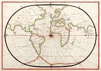
Kaart van Griekenland by Abraham Ortelius (1527–1598). Original from The Rijksmuseum. Digitally enhanced by rawpixel.![Portolan atlas of the Mediterranean Sea, western Europe, and the northwest coast of Africa: World map drawn on an oval…]() Portolan atlas of the Mediterranean Sea, western Europe, and the northwest coast of Africa: World map drawn on an oval…
Portolan atlas of the Mediterranean Sea, western Europe, and the northwest coast of Africa: World map drawn on an oval…![Kaart van de kust van Zweden tussen Kalmar en Stockholm (ca. 1580–1583) by Joannes van Doetechum (I). Original from…]() Kaart van de kust van Zweden tussen Kalmar en Stockholm (ca. 1580–1583) by Joannes van Doetechum (I). Original from…
Kaart van de kust van Zweden tussen Kalmar en Stockholm (ca. 1580–1583) by Joannes van Doetechum (I). Original from…![Western Hemisphere map vintage illustration, remix from original artwork.]() Western Hemisphere map vintage illustration, remix from original artwork.
Western Hemisphere map vintage illustration, remix from original artwork.![World map from A System of Geography, for the use of Schools (1860) published by Sidney Edwards Morse. Original from the…]() World map from A System of Geography, for the use of Schools (1860) published by Sidney Edwards Morse. Original from the…
World map from A System of Geography, for the use of Schools (1860) published by Sidney Edwards Morse. Original from the…![World map from A System of Geography, for the use of Schools (1860) published by Sidney Edwards Morse. Original from the…]() World map from A System of Geography, for the use of Schools (1860) published by Sidney Edwards Morse. Original from the…
World map from A System of Geography, for the use of Schools (1860) published by Sidney Edwards Morse. Original from the…![Earth illustration, vintage artwork]() Earth illustration, vintage artwork
Earth illustration, vintage artwork![Earth illustration, vintage artwork, ripped paper badge]() Earth illustration, vintage artwork, ripped paper badge
Earth illustration, vintage artwork, ripped paper badge![Earth collage element, hand drawn artwork psd]() Earth collage element, hand drawn artwork psd
Earth collage element, hand drawn artwork psd![Earth collage element, hand drawn artwork psd]() Earth collage element, hand drawn artwork psd
Earth collage element, hand drawn artwork psd![Earth illustration, vintage artwork]() Earth illustration, vintage artwork
Earth illustration, vintage artwork![Noua, et integra uniuersi orbis descriptio (1531) by Oronce Finé. Original from Library of Congress. Digitally…]() Noua, et integra uniuersi orbis descriptio (1531) by Oronce Finé. Original from Library of Congress. Digitally…
Noua, et integra uniuersi orbis descriptio (1531) by Oronce Finé. Original from Library of Congress. Digitally…![Earth illustration, vintage artwork, ripped paper badge]() Earth illustration, vintage artwork, ripped paper badge
Earth illustration, vintage artwork, ripped paper badge![The Mackenzie River in the Northwest Territories, Canada. Original from NASA. Digitally enhanced by rawpixel.]() The Mackenzie River in the Northwest Territories, Canada. Original from NASA. Digitally enhanced by rawpixel.
The Mackenzie River in the Northwest Territories, Canada. Original from NASA. Digitally enhanced by rawpixel.![Earth png sticker, hand drawn illustration, transparent background, ripped paper badge]() Earth png sticker, hand drawn illustration, transparent background, ripped paper badge
Earth png sticker, hand drawn illustration, transparent background, ripped paper badge![Bacon's standard map of Europe vintage illustration wall art print and poster design remix from original artwork.]() Bacon's standard map of Europe vintage illustration wall art print and poster design remix from original artwork.
Bacon's standard map of Europe vintage illustration wall art print and poster design remix from original artwork.![Earth png sticker, hand drawn illustration, transparent background]() Earth png sticker, hand drawn illustration, transparent background
Earth png sticker, hand drawn illustration, transparent background![Earth png sticker, hand drawn illustration, transparent background, ripped paper badge]() Earth png sticker, hand drawn illustration, transparent background, ripped paper badge
Earth png sticker, hand drawn illustration, transparent background, ripped paper badge![Earth png sticker, hand drawn illustration, transparent background]() Earth png sticker, hand drawn illustration, transparent background
Earth png sticker, hand drawn illustration, transparent background![Lying in the eastern Mediterranean Sea, the entire Island of Crete (35.0N, 25.0E) can be seen in great detail in this cloud…]() Lying in the eastern Mediterranean Sea, the entire Island of Crete (35.0N, 25.0E) can be seen in great detail in this cloud…
Lying in the eastern Mediterranean Sea, the entire Island of Crete (35.0N, 25.0E) can be seen in great detail in this cloud…