![Port Royal, South Carolina illustration from Grand voyages (1596) by Theodor de Bry (1528-1598). Original from The New York…]() Port Royal, South Carolina illustration from Grand voyages (1596) by Theodor de Bry (1528-1598). Original from The New York…
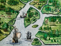
Port Royal, South Carolina illustration from Grand voyages (1596) by Theodor de Bry (1528-1598). Original from The New York…![America map from Grand voyages (1596) by Theodor de Bry (1528-1598). Original from The New York Public Library. Digitally…]() America map from Grand voyages (1596) by Theodor de Bry (1528-1598). Original from The New York Public Library. Digitally…
America map from Grand voyages (1596) by Theodor de Bry (1528-1598). Original from The New York Public Library. Digitally…![Grand voyages, Part VIII title page from Grand voyages (1596) by Theodor de Bry (1528-1598). Original from The New York…]() Grand voyages, Part VIII title page from Grand voyages (1596) by Theodor de Bry (1528-1598). Original from The New York…
Grand voyages, Part VIII title page from Grand voyages (1596) by Theodor de Bry (1528-1598). Original from The New York…![Leaving the River of May, the French discover two other rivers ; Six other rivers discovered by the French illustration from…]() Leaving the River of May, the French discover two other rivers ; Six other rivers discovered by the French illustration from…
Leaving the River of May, the French discover two other rivers ; Six other rivers discovered by the French illustration from…![French left in Fort Charles suffer from scarcity of provisions ; Natives of Florida worship the column erected by the…]() French left in Fort Charles suffer from scarcity of provisions ; Natives of Florida worship the column erected by the…
French left in Fort Charles suffer from scarcity of provisions ; Natives of Florida worship the column erected by the…![Promontory of Florida at which the French touched, named by them the French Promontory ; French sail to the River of May…]() Promontory of Florida at which the French touched, named by them the French Promontory ; French sail to the River of May…
Promontory of Florida at which the French touched, named by them the French Promontory ; French sail to the River of May…![Local indians making sugar in America illustration from Grand voyages (1596) by Theodor de Bry (1528-1598). Original from…]() Local indians making sugar in America illustration from Grand voyages (1596) by Theodor de Bry (1528-1598). Original from…
Local indians making sugar in America illustration from Grand voyages (1596) by Theodor de Bry (1528-1598). Original from…![Christopher Columbus illustration from Grand voyages (1596) by Theodor de Bry (1528-1598). Original from The New York Public…]() Christopher Columbus illustration from Grand voyages (1596) by Theodor de Bry (1528-1598). Original from The New York Public…
Christopher Columbus illustration from Grand voyages (1596) by Theodor de Bry (1528-1598). Original from The New York Public…![Leaving the River of May, the French discover two other rivers ; Six other rivers discovered by the French illustration from…]() Leaving the River of May, the French discover two other rivers ; Six other rivers discovered by the French illustration from…
Leaving the River of May, the French discover two other rivers ; Six other rivers discovered by the French illustration from…![How they till the soil and plant ; Storing their crops in the public granary illustration from Grand voyages (1596) by…]() How they till the soil and plant ; Storing their crops in the public granary illustration from Grand voyages (1596) by…
How they till the soil and plant ; Storing their crops in the public granary illustration from Grand voyages (1596) by…![French left in Fort Charles suffer from scarcity of provisions ; Natives of Florida worship the column erected by the…]() French left in Fort Charles suffer from scarcity of provisions ; Natives of Florida worship the column erected by the…
French left in Fort Charles suffer from scarcity of provisions ; Natives of Florida worship the column erected by the…![Promontory of Florida at which the French touched, named by them the French Promontory ; French sail to the River of May…]() Promontory of Florida at which the French touched, named by them the French Promontory ; French sail to the River of May…
Promontory of Florida at which the French touched, named by them the French Promontory ; French sail to the River of May…![Deer hunting illustration from Grand voyages (1596) by Theodor de Bry (1528-1598). Original from The New York Public…]() Deer hunting illustration from Grand voyages (1596) by Theodor de Bry (1528-1598). Original from The New York Public…
Deer hunting illustration from Grand voyages (1596) by Theodor de Bry (1528-1598). Original from The New York Public…![Crocodile hunting illustration from Grand voyages (1596) by Theodor de Bry (1528-1598). Original from The New York Public…]() Crocodile hunting illustration from Grand voyages (1596) by Theodor de Bry (1528-1598). Original from The New York Public…
Crocodile hunting illustration from Grand voyages (1596) by Theodor de Bry (1528-1598). Original from The New York Public…![Deer hunting and Crocodile hunting illustration from Grand voyages (1596) by Theodor de Bry (1528-1598). Original from The…]() Deer hunting and Crocodile hunting illustration from Grand voyages (1596) by Theodor de Bry (1528-1598). Original from The…
Deer hunting and Crocodile hunting illustration from Grand voyages (1596) by Theodor de Bry (1528-1598). Original from The…![A men's dance illustration from Grand voyages (1596) by Theodor de Bry (1528-1598). Original from The New York Public…]() A men's dance illustration from Grand voyages (1596) by Theodor de Bry (1528-1598). Original from The New York Public…
A men's dance illustration from Grand voyages (1596) by Theodor de Bry (1528-1598). Original from The New York Public…![Ceremonies Performed by Saturioua Before Going on an Expedition Against the Enemy illustration from Grand voyages (1596) by…]() Ceremonies Performed by Saturioua Before Going on an Expedition Against the Enemy illustration from Grand voyages (1596) by…
Ceremonies Performed by Saturioua Before Going on an Expedition Against the Enemy illustration from Grand voyages (1596) by…![Method of smoking fish, game and other provisions illustration from Grand voyages (1596) by Theodor de Bry (1528-1598).…]() Method of smoking fish, game and other provisions illustration from Grand voyages (1596) by Theodor de Bry (1528-1598).…
Method of smoking fish, game and other provisions illustration from Grand voyages (1596) by Theodor de Bry (1528-1598).…![Method of setting an enemy town on fire at night illustration from Grand voyages (1596) by Theodor de Bry (1528-1598).…]() Method of setting an enemy town on fire at night illustration from Grand voyages (1596) by Theodor de Bry (1528-1598).…
Method of setting an enemy town on fire at night illustration from Grand voyages (1596) by Theodor de Bry (1528-1598).…![Carrying the wounded ; The widows approach the chief illustration from Grand voyages (1596) by Theodor de Bry (1528-1598).…]() Carrying the wounded ; The widows approach the chief illustration from Grand voyages (1596) by Theodor de Bry (1528-1598).…
Carrying the wounded ; The widows approach the chief illustration from Grand voyages (1596) by Theodor de Bry (1528-1598).…![Carrying the wounded ; The widows approach the chief illustration from Grand voyages (1596) by Theodor de Bry (1528-1598).…]() Carrying the wounded ; The widows approach the chief illustration from Grand voyages (1596) by Theodor de Bry (1528-1598).…
Carrying the wounded ; The widows approach the chief illustration from Grand voyages (1596) by Theodor de Bry (1528-1598).…![Method of setting an enemy town on fire at night ; How sentinels are punished for sleeping on their posts illustration from…]() Method of setting an enemy town on fire at night ; How sentinels are punished for sleeping on their posts illustration from…
Method of setting an enemy town on fire at night ; How sentinels are punished for sleeping on their posts illustration from…![Pride and Folly illustration from Grand voyages (1596) by Theodor de Bry (1528-1598). Original from The New York Public…]() Pride and Folly illustration from Grand voyages (1596) by Theodor de Bry (1528-1598). Original from The New York Public…
Pride and Folly illustration from Grand voyages (1596) by Theodor de Bry (1528-1598). Original from The New York Public…![A council of state and A fortified village ; Construction of a native Floridian town illustration from Grand voyages (1596)…]() A council of state and A fortified village ; Construction of a native Floridian town illustration from Grand voyages (1596)…
A council of state and A fortified village ; Construction of a native Floridian town illustration from Grand voyages (1596)…![How they till the soil and plant ; Storing their crops in the public granary illustration from Grand voyages (1596) by…]() How they till the soil and plant ; Storing their crops in the public granary illustration from Grand voyages (1596) by…
How they till the soil and plant ; Storing their crops in the public granary illustration from Grand voyages (1596) by…![Deer hunting and Crocodile hunting illustration from Grand voyages (1596) by Theodor de Bry (1528-1598). Original from The…]() Deer hunting and Crocodile hunting illustration from Grand voyages (1596) by Theodor de Bry (1528-1598). Original from The…
Deer hunting and Crocodile hunting illustration from Grand voyages (1596) by Theodor de Bry (1528-1598). Original from The…![A council of state and A fortified village ; Construction of a native Floridian town illustration from Grand voyages (1596)…]() A council of state and A fortified village ; Construction of a native Floridian town illustration from Grand voyages (1596)…
A council of state and A fortified village ; Construction of a native Floridian town illustration from Grand voyages (1596)…![Outina, aided by the French, overcomes his enemy, Potanou ; Outina departs for war with military discipline illustration…]() Outina, aided by the French, overcomes his enemy, Potanou ; Outina departs for war with military discipline illustration…
Outina, aided by the French, overcomes his enemy, Potanou ; Outina departs for war with military discipline illustration…![How Outina's soldiers treated the bodies of the enemy ; Trophies and solemn rites after an enemy's defeat illustration from…]() How Outina's soldiers treated the bodies of the enemy ; Trophies and solemn rites after an enemy's defeat illustration from…
How Outina's soldiers treated the bodies of the enemy ; Trophies and solemn rites after an enemy's defeat illustration from…![Outina, aided by the French, overcomes his enemy, Potanou ; Outina departs for war with military discipline illustration…]() Outina, aided by the French, overcomes his enemy, Potanou ; Outina departs for war with military discipline illustration…
Outina, aided by the French, overcomes his enemy, Potanou ; Outina departs for war with military discipline illustration…![How Outina's soldiers treated the bodies of the enemy ; Trophies and solemn rites after an enemy's defeat illustration from…]() How Outina's soldiers treated the bodies of the enemy ; Trophies and solemn rites after an enemy's defeat illustration from…
How Outina's soldiers treated the bodies of the enemy ; Trophies and solemn rites after an enemy's defeat illustration from…![Indians being attacked by dogs illustration from Grand voyages (1596) by Theodor de Bry (1528-1598). Original from The New…]() Indians being attacked by dogs illustration from Grand voyages (1596) by Theodor de Bry (1528-1598). Original from The New…
Indians being attacked by dogs illustration from Grand voyages (1596) by Theodor de Bry (1528-1598). Original from The New…![Battle between Francisco Poras and Columbus on Jamaica illustration from Grand voyages (1596) by Theodor de Bry (1528-1598).…]() Battle between Francisco Poras and Columbus on Jamaica illustration from Grand voyages (1596) by Theodor de Bry (1528-1598).…
Battle between Francisco Poras and Columbus on Jamaica illustration from Grand voyages (1596) by Theodor de Bry (1528-1598).…![Battle between Francisco Poras and Columbus on Jamaica illustration from Grand voyages (1596) by Theodor de Bry (1528-1598).…]() Battle between Francisco Poras and Columbus on Jamaica illustration from Grand voyages (1596) by Theodor de Bry (1528-1598).…
Battle between Francisco Poras and Columbus on Jamaica illustration from Grand voyages (1596) by Theodor de Bry (1528-1598).…![Method of setting an enemy town on fire at night ; How sentinels are punished for sleeping on their posts illustration from…]() Method of setting an enemy town on fire at night ; How sentinels are punished for sleeping on their posts illustration from…
Method of setting an enemy town on fire at night ; How sentinels are punished for sleeping on their posts illustration from…![Typus orbis terrarum (1587–1595) by Abraham Ortelius. Original From The New York Public Library. Digitally enhanced by…]() Typus orbis terrarum (1587–1595) by Abraham Ortelius. Original From The New York Public Library. Digitally enhanced by…
Typus orbis terrarum (1587–1595) by Abraham Ortelius. Original From The New York Public Library. Digitally enhanced by…![Philips' war map of the Pacific (1945) by George Philip and Son Limited. Original from The Beinecke Rare Book & Manuscript…]() Philips' war map of the Pacific (1945) by George Philip and Son Limited. Original from The Beinecke Rare Book & Manuscript…
Philips' war map of the Pacific (1945) by George Philip and Son Limited. Original from The Beinecke Rare Book & Manuscript…![Up-to-date map of the world war (1942) by Manila Shinbun-sha. Original from The Beinecke Rare Book & Manuscript Library.…]() Up-to-date map of the world war (1942) by Manila Shinbun-sha. Original from The Beinecke Rare Book & Manuscript Library.…
Up-to-date map of the world war (1942) by Manila Shinbun-sha. Original from The Beinecke Rare Book & Manuscript Library.…![Portolan atlas of the Mediterranean Sea, western Europe, and the northwest coast of Africa: World map drawn on an oval…]() Portolan atlas of the Mediterranean Sea, western Europe, and the northwest coast of Africa: World map drawn on an oval…
Portolan atlas of the Mediterranean Sea, western Europe, and the northwest coast of Africa: World map drawn on an oval…![World atlas from Voyeur's Checklist, General Notions Of Mathematical Geography, Physical Geography, Political Geography…]() World atlas from Voyeur's Checklist, General Notions Of Mathematical Geography, Physical Geography, Political Geography…
World atlas from Voyeur's Checklist, General Notions Of Mathematical Geography, Physical Geography, Political Geography…![World atlas from Voyeur's Checklist, General Notions Of Mathematical Geography, Physical Geography, Political Geography…]() World atlas from Voyeur's Checklist, General Notions Of Mathematical Geography, Physical Geography, Political Geography…
World atlas from Voyeur's Checklist, General Notions Of Mathematical Geography, Physical Geography, Political Geography…![World atlas from The Practical Teaching of Geography. Atlas, Maps, Texts and Questionnaires... Elementary Course (1878).…]() World atlas from The Practical Teaching of Geography. Atlas, Maps, Texts and Questionnaires... Elementary Course (1878).…
World atlas from The Practical Teaching of Geography. Atlas, Maps, Texts and Questionnaires... Elementary Course (1878).…![Flags at Fort Sumter in South Carolina. Original image from Carol M. Highsmith’s America, Library of Congress…]() Flags at Fort Sumter in South Carolina. Original image from Carol M. Highsmith’s America, Library of Congress…
Flags at Fort Sumter in South Carolina. Original image from Carol M. Highsmith’s America, Library of Congress…![World atlas from Voyeur's Checklist, General Notions Of Mathematical Geography, Physical Geography, Political Geography…]() World atlas from Voyeur's Checklist, General Notions Of Mathematical Geography, Physical Geography, Political Geography…
World atlas from Voyeur's Checklist, General Notions Of Mathematical Geography, Physical Geography, Political Geography…![World atlas from The Practical Teaching of Geography. Atlas, Maps, Texts and Questionnaires... Elementary Course (1878).…]() World atlas from The Practical Teaching of Geography. Atlas, Maps, Texts and Questionnaires... Elementary Course (1878).…
World atlas from The Practical Teaching of Geography. Atlas, Maps, Texts and Questionnaires... Elementary Course (1878).…![World atlas from Voyeur's Checklist, General Notions Of Mathematical Geography, Physical Geography, Political Geography…]() World atlas from Voyeur's Checklist, General Notions Of Mathematical Geography, Physical Geography, Political Geography…
World atlas from Voyeur's Checklist, General Notions Of Mathematical Geography, Physical Geography, Political Geography…![World atlas from The Practical Teaching of Geography. Atlas, Maps, Texts and Questionnaires... Elementary Course (1878).…]() World atlas from The Practical Teaching of Geography. Atlas, Maps, Texts and Questionnaires... Elementary Course (1878).…
World atlas from The Practical Teaching of Geography. Atlas, Maps, Texts and Questionnaires... Elementary Course (1878).…![World atlas from The Practical Teaching of Geography. Atlas, Maps, Texts and Questionnaires... Elementary Course (1878).…]() World atlas from The Practical Teaching of Geography. Atlas, Maps, Texts and Questionnaires... Elementary Course (1878).…
World atlas from The Practical Teaching of Geography. Atlas, Maps, Texts and Questionnaires... Elementary Course (1878).…![The Voyages of Captain James Cook (1852) by James Cook. Original from British Library. Digitally enhanced by rawpixel.]() The Voyages of Captain James Cook (1852) by James Cook. Original from British Library. Digitally enhanced by rawpixel.
The Voyages of Captain James Cook (1852) by James Cook. Original from British Library. Digitally enhanced by rawpixel.![Kaart van de noordkust van Engeland bij Newcastle upon Tyne (1580–1583) by Joannes van Doetechum (I). Original from…]() Kaart van de noordkust van Engeland bij Newcastle upon Tyne (1580–1583) by Joannes van Doetechum (I). Original from…
Kaart van de noordkust van Engeland bij Newcastle upon Tyne (1580–1583) by Joannes van Doetechum (I). Original from…![Kaartje van Kaap de Goede Hoop (1595) by anonymous. Original from The Rijksmuseum. Digitally enhanced by rawpixel.]() Kaartje van Kaap de Goede Hoop (1595) by anonymous. Original from The Rijksmuseum. Digitally enhanced by rawpixel.
Kaartje van Kaap de Goede Hoop (1595) by anonymous. Original from The Rijksmuseum. Digitally enhanced by rawpixel.![View of Antwerp from Braun and Hogenberg's Civitates Orbis Terrarum (1572–1594) designed by Joris Hoefnagel and edited…]() View of Antwerp from Braun and Hogenberg's Civitates Orbis Terrarum (1572–1594) designed by Joris Hoefnagel and edited…
View of Antwerp from Braun and Hogenberg's Civitates Orbis Terrarum (1572–1594) designed by Joris Hoefnagel and edited…![Map of Alexandria (1575) by Georg Braun. Original from The MET Museum. Digitally enhanced by rawpixel.]() Map of Alexandria (1575) by Georg Braun. Original from The MET Museum. Digitally enhanced by rawpixel.
Map of Alexandria (1575) by Georg Braun. Original from The MET Museum. Digitally enhanced by rawpixel.![Kaart van Griekenland by Abraham Ortelius (1527–1598). Original from The Rijksmuseum. Digitally enhanced by rawpixel.]() Kaart van Griekenland by Abraham Ortelius (1527–1598). Original from The Rijksmuseum. Digitally enhanced by rawpixel.
Kaart van Griekenland by Abraham Ortelius (1527–1598). Original from The Rijksmuseum. Digitally enhanced by rawpixel.![Kaart van de kusten van Vlaanderen, Normandië en Engeland (ca. 1580–1581) by Joannes van Doetechum (I). Original…]() Kaart van de kusten van Vlaanderen, Normandië en Engeland (ca. 1580–1581) by Joannes van Doetechum (I). Original…
Kaart van de kusten van Vlaanderen, Normandië en Engeland (ca. 1580–1581) by Joannes van Doetechum (I). Original…![Kaart van de Zuidengelse kust tussen de Isle of Wight en Dover (ca. 1580–1583) by Joannes van Doetechum (I). Original…]() Kaart van de Zuidengelse kust tussen de Isle of Wight en Dover (ca. 1580–1583) by Joannes van Doetechum (I). Original…
Kaart van de Zuidengelse kust tussen de Isle of Wight en Dover (ca. 1580–1583) by Joannes van Doetechum (I). Original…![Kaart van Zeeland (1592) by Frans Hogenberg. Original from The Rijksmuseum. Digitally enhanced by rawpixel.]() Kaart van Zeeland (1592) by Frans Hogenberg. Original from The Rijksmuseum. Digitally enhanced by rawpixel.
Kaart van Zeeland (1592) by Frans Hogenberg. Original from The Rijksmuseum. Digitally enhanced by rawpixel.![Kaart van het Noordpoolgebied (1598) by Willem Barendsz. Original from The Rijksmuseum. Digitally enhanced by rawpixel.]() Kaart van het Noordpoolgebied (1598) by Willem Barendsz. Original from The Rijksmuseum. Digitally enhanced by rawpixel.
Kaart van het Noordpoolgebied (1598) by Willem Barendsz. Original from The Rijksmuseum. Digitally enhanced by rawpixel.![Portolan atlas of the Mediterranean Sea, western Europe, and the northwest coast of Africa: World map drawn on an oval…]() Portolan atlas of the Mediterranean Sea, western Europe, and the northwest coast of Africa: World map drawn on an oval…
Portolan atlas of the Mediterranean Sea, western Europe, and the northwest coast of Africa: World map drawn on an oval…![Kaart van de kust van Zweden tussen Kalmar en Stockholm (ca. 1580–1583) by Joannes van Doetechum (I). Original from…]() Kaart van de kust van Zweden tussen Kalmar en Stockholm (ca. 1580–1583) by Joannes van Doetechum (I). Original from…
Kaart van de kust van Zweden tussen Kalmar en Stockholm (ca. 1580–1583) by Joannes van Doetechum (I). Original from…![Noua, et integra uniuersi orbis descriptio (1531) by Oronce Finé. Original from Library of Congress. Digitally…]() Noua, et integra uniuersi orbis descriptio (1531) by Oronce Finé. Original from Library of Congress. Digitally…
Noua, et integra uniuersi orbis descriptio (1531) by Oronce Finé. Original from Library of Congress. Digitally…![Americæ pars, nunc Virginia dicta, primum ab Anglis inuenta, sumtibus Dn. Walteri Raleigh, equestris ordinis…]() Americæ pars, nunc Virginia dicta, primum ab Anglis inuenta, sumtibus Dn. Walteri Raleigh, equestris ordinis…
Americæ pars, nunc Virginia dicta, primum ab Anglis inuenta, sumtibus Dn. Walteri Raleigh, equestris ordinis…![Zum Weltkrieg 1914! (1914) by W. Karnahl. Original from The Beinecke Rare Book & Manuscript Library. Digitally enhanced by…]() Zum Weltkrieg 1914! (1914) by W. Karnahl. Original from The Beinecke Rare Book & Manuscript Library. Digitally enhanced by…
Zum Weltkrieg 1914! (1914) by W. Karnahl. Original from The Beinecke Rare Book & Manuscript Library. Digitally enhanced by…![Vintage Victorian style compass engraving. Original from the British Library. Digitally enhanced by rawpixel.]() Vintage Victorian style compass engraving. Original from the British Library. Digitally enhanced by rawpixel.
Vintage Victorian style compass engraving. Original from the British Library. Digitally enhanced by rawpixel.![Vintage Victorian style compass engraving. Original from the British Library. Digitally enhanced by rawpixel.]() Vintage Victorian style compass engraving. Original from the British Library. Digitally enhanced by rawpixel.
Vintage Victorian style compass engraving. Original from the British Library. Digitally enhanced by rawpixel.![A map of Carolina, Florida and the Bahama Islands with the adjacent parts from The Natural History of Carolina, Florida, and…]() A map of Carolina, Florida and the Bahama Islands with the adjacent parts from The Natural History of Carolina, Florida, and…
A map of Carolina, Florida and the Bahama Islands with the adjacent parts from The Natural History of Carolina, Florida, and…![Portolan atlas of the Mediterranean Sea, western Europe, and the northwest coast of Africa: Eastern Mediterranean (ca. 1590)…]() Portolan atlas of the Mediterranean Sea, western Europe, and the northwest coast of Africa: Eastern Mediterranean (ca. 1590)…
Portolan atlas of the Mediterranean Sea, western Europe, and the northwest coast of Africa: Eastern Mediterranean (ca. 1590)…![Portolan atlas of the Mediterranean Sea, western Europe, and the northwest coast of Africa: Central Mediterranean (ca. 1590)…]() Portolan atlas of the Mediterranean Sea, western Europe, and the northwest coast of Africa: Central Mediterranean (ca. 1590)…
Portolan atlas of the Mediterranean Sea, western Europe, and the northwest coast of Africa: Central Mediterranean (ca. 1590)…![The Mackenzie River in the Northwest Territories, Canada. Original from NASA. Digitally enhanced by rawpixel.]() The Mackenzie River in the Northwest Territories, Canada. Original from NASA. Digitally enhanced by rawpixel.
The Mackenzie River in the Northwest Territories, Canada. Original from NASA. Digitally enhanced by rawpixel.![Acadia National Park is one of the most visited parks in America. Original from NASA. Digitally enhanced by rawpixel.]() Acadia National Park is one of the most visited parks in America. Original from NASA. Digitally enhanced by rawpixel.
Acadia National Park is one of the most visited parks in America. Original from NASA. Digitally enhanced by rawpixel.![British Islands approximate positions of minefields (1918) by William Rea Furlong. Original from Library of Congress.…]() British Islands approximate positions of minefields (1918) by William Rea Furlong. Original from Library of Congress.…
British Islands approximate positions of minefields (1918) by William Rea Furlong. Original from Library of Congress.…![The Olympic National Park has to be one of America’s most diverse national park landscapes. Original from NASA.…]() The Olympic National Park has to be one of America’s most diverse national park landscapes. Original from NASA.…
The Olympic National Park has to be one of America’s most diverse national park landscapes. Original from NASA.…![Earth observations of Argentina and Chile was among several of South America. Original from NASA. Digitally enhanced by…]() Earth observations of Argentina and Chile was among several of South America. Original from NASA. Digitally enhanced by…
Earth observations of Argentina and Chile was among several of South America. Original from NASA. Digitally enhanced by…![Classic View of the Washington Monument. Original image from Carol M. Highsmith’s America, Library of Congress…]() Classic View of the Washington Monument. Original image from Carol M. Highsmith’s America, Library of Congress…
Classic View of the Washington Monument. Original image from Carol M. Highsmith’s America, Library of Congress…![Washington Monument, Washington, D.C. Original image from Carol M. Highsmith’s America, Library of Congress…]() Washington Monument, Washington, D.C. Original image from Carol M. Highsmith’s America, Library of Congress…
Washington Monument, Washington, D.C. Original image from Carol M. Highsmith’s America, Library of Congress…![September 11th remembrance ceremony held in front of NASA Research Park Bldg-17. Original from NASA. Digitally enhanced by…]() September 11th remembrance ceremony held in front of NASA Research Park Bldg-17. Original from NASA. Digitally enhanced by…
September 11th remembrance ceremony held in front of NASA Research Park Bldg-17. Original from NASA. Digitally enhanced by…![World atlas illustration vector]() World atlas illustration vector
World atlas illustration vector![Costumed characters at the 1863 Battle of Gettysburg, in Pennsylvania. Original image from Carol M. Highsmith’s…]() Costumed characters at the 1863 Battle of Gettysburg, in Pennsylvania. Original image from Carol M. Highsmith’s…
Costumed characters at the 1863 Battle of Gettysburg, in Pennsylvania. Original image from Carol M. Highsmith’s…![Costumed characters at the 1863 Battle of Gettysburg, in Pennsylvania. Original image from Carol M. Highsmith’s…]() Costumed characters at the 1863 Battle of Gettysburg, in Pennsylvania. Original image from Carol M. Highsmith’s…
Costumed characters at the 1863 Battle of Gettysburg, in Pennsylvania. Original image from Carol M. Highsmith’s…![Drawing of a world atlas]() Drawing of a world atlas
Drawing of a world atlas![Drawing of a world atlas]() Drawing of a world atlas
Drawing of a world atlas![Drawing of a world atlas]() Drawing of a world atlas
Drawing of a world atlas![Drawing of a world atlas]() Drawing of a world atlas
Drawing of a world atlas![Drawing of a world atlas]() Drawing of a world atlas
Drawing of a world atlas![Drawing of a world atlas]() Drawing of a world atlas
Drawing of a world atlas![The Cantino planisphere, completed by an unknown Portuguese cartographer in 1502, is one of the most precious cartographic…]() The Cantino planisphere, completed by an unknown Portuguese cartographer in 1502, is one of the most precious cartographic…
The Cantino planisphere, completed by an unknown Portuguese cartographer in 1502, is one of the most precious cartographic…![Vertrek van Girolamo Benzoni uit een Spaanse haven (1594) by Theodor de Bry, Johann Theodor de Bry and Theodor de Bry]() Vertrek van Girolamo Benzoni uit een Spaanse haven (1594) by Theodor de Bry, Johann Theodor de Bry and Theodor de Bry
Vertrek van Girolamo Benzoni uit een Spaanse haven (1594) by Theodor de Bry, Johann Theodor de Bry and Theodor de Bry![World atlas illustration vector]() World atlas illustration vector
World atlas illustration vector![Costumed character at the 1863 Battle of Gettysburg, in Pennsylvania. Original image from Carol M. Highsmith’s…]() Costumed character at the 1863 Battle of Gettysburg, in Pennsylvania. Original image from Carol M. Highsmith’s…
Costumed character at the 1863 Battle of Gettysburg, in Pennsylvania. Original image from Carol M. Highsmith’s…![Vintage Victorian style compass vector]() Vintage Victorian style compass vector
Vintage Victorian style compass vector![Drawing of a world atlas]() Drawing of a world atlas
Drawing of a world atlas![World atlas illustration vector]() World atlas illustration vector
World atlas illustration vector![World atlas illustration vector]() World atlas illustration vector
World atlas illustration vector![World atlas illustration vector]() World atlas illustration vector
World atlas illustration vector![Drawing of a world atlas]() Drawing of a world atlas
Drawing of a world atlas![A Moral and Political Sketch of the United States of North America with a note on Negro Slavery, Junius Redivivus (1833) by…]() A Moral and Political Sketch of the United States of North America with a note on Negro Slavery, Junius Redivivus (1833) by…
A Moral and Political Sketch of the United States of North America with a note on Negro Slavery, Junius Redivivus (1833) by…![Nova totius terrarum orbis geographica ac hydrographica (ca. 1635–1650) by Guiljelmo Blaeuw. Original from The…]() Nova totius terrarum orbis geographica ac hydrographica (ca. 1635–1650) by Guiljelmo Blaeuw. Original from The…
Nova totius terrarum orbis geographica ac hydrographica (ca. 1635–1650) by Guiljelmo Blaeuw. Original from The…![Colton's Map of the World on Mercator's Projection (1858) by J.H. Colton & Co. Original from The Beinecke Rare Book &…]() Colton's Map of the World on Mercator's Projection (1858) by J.H. Colton & Co. Original from The Beinecke Rare Book &…
Colton's Map of the World on Mercator's Projection (1858) by J.H. Colton & Co. Original from The Beinecke Rare Book &…