![Vintage Victorian style compass engraving]() Vintage Victorian style compass engraving
Vintage Victorian style compass engraving![Vintage Victorian style compass engraving]() Vintage Victorian style compass engraving
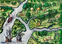
Vintage Victorian style compass engraving![Newe Welt vnd americanische Historien : Inhaltende Warhafftige vnd vollkommene Beschreibungen aller west-indianischen…]() Newe Welt vnd americanische Historien : Inhaltende Warhafftige vnd vollkommene Beschreibungen aller west-indianischen…
Newe Welt vnd americanische Historien : Inhaltende Warhafftige vnd vollkommene Beschreibungen aller west-indianischen…![Newe Welt vnd americanische Historien : Inhaltende Warhafftige vnd vollkommene Beschreibungen aller west-indianischen…]() Newe Welt vnd americanische Historien : Inhaltende Warhafftige vnd vollkommene Beschreibungen aller west-indianischen…
Newe Welt vnd americanische Historien : Inhaltende Warhafftige vnd vollkommene Beschreibungen aller west-indianischen…![Vintage locomotive and compass engraving]() Vintage locomotive and compass engraving
Vintage locomotive and compass engraving![The Olympic National Park has to be one of America’s most diverse national park landscapes. Original from NASA.…]() The Olympic National Park has to be one of America’s most diverse national park landscapes. Original from NASA.…
The Olympic National Park has to be one of America’s most diverse national park landscapes. Original from NASA.…![PNG Drawing of a world atlas, transparent background]() PNG Drawing of a world atlas, transparent background
PNG Drawing of a world atlas, transparent background![PNG Drawing of a world atlas, transparent background]() PNG Drawing of a world atlas, transparent background
PNG Drawing of a world atlas, transparent background![PNG Drawing of a world atlas, transparent background]() PNG Drawing of a world atlas, transparent background
PNG Drawing of a world atlas, transparent background![The Cantino planisphere, completed by an unknown Portuguese cartographer in 1502, is one of the most precious cartographic…]() The Cantino planisphere, completed by an unknown Portuguese cartographer in 1502, is one of the most precious cartographic…
The Cantino planisphere, completed by an unknown Portuguese cartographer in 1502, is one of the most precious cartographic…![PNG Drawing of a world atlas, transparent background]() PNG Drawing of a world atlas, transparent background
PNG Drawing of a world atlas, transparent background![PNG Drawing of a world atlas, transparent background]() PNG Drawing of a world atlas, transparent background
PNG Drawing of a world atlas, transparent background![PNG Drawing of a world atlas, transparent background]() PNG Drawing of a world atlas, transparent background
PNG Drawing of a world atlas, transparent background![PNG Drawing of a world atlas, transparent background]() PNG Drawing of a world atlas, transparent background
PNG Drawing of a world atlas, transparent background![The Thirty-Six Star Flag of the United States of America by an unknown artist. Original from Library of Congress. Digitally…]() The Thirty-Six Star Flag of the United States of America by an unknown artist. Original from Library of Congress. Digitally…
The Thirty-Six Star Flag of the United States of America by an unknown artist. Original from Library of Congress. Digitally…![America with those known parts in that unknowne worlde both people and manner of buildings/discribed and inlarged (ca.…]() America with those known parts in that unknowne worlde both people and manner of buildings/discribed and inlarged (ca.…
America with those known parts in that unknowne worlde both people and manner of buildings/discribed and inlarged (ca.…![Mappa totius mundi : adornata juxta observationes dnn. academiae regalis scientiarum et nonnullorum aliorum secundum…]() Mappa totius mundi : adornata juxta observationes dnn. academiae regalis scientiarum et nonnullorum aliorum secundum…
Mappa totius mundi : adornata juxta observationes dnn. academiae regalis scientiarum et nonnullorum aliorum secundum…![Earth observations of Argentina and Chile was among several of South America. Original from NASA. Digitally enhanced by…]() Earth observations of Argentina and Chile was among several of South America. Original from NASA. Digitally enhanced by…
Earth observations of Argentina and Chile was among several of South America. Original from NASA. Digitally enhanced by…![A Moral and Political Sketch of the United States of North America with a note on Negro Slavery, Junius Redivivus (1833) by…]() A Moral and Political Sketch of the United States of North America with a note on Negro Slavery, Junius Redivivus (1833) by…
A Moral and Political Sketch of the United States of North America with a note on Negro Slavery, Junius Redivivus (1833) by…![World map from A System of Geography, for the use of Schools (1860) published by Sidney Edwards Morse. Original from the…]() World map from A System of Geography, for the use of Schools (1860) published by Sidney Edwards Morse. Original from the…
World map from A System of Geography, for the use of Schools (1860) published by Sidney Edwards Morse. Original from the…![New World, or, Western Hemisphere; Old World, or Eastern Hemisphere (1790) by William Faden. Original From The New York…]() New World, or, Western Hemisphere; Old World, or Eastern Hemisphere (1790) by William Faden. Original From The New York…
New World, or, Western Hemisphere; Old World, or Eastern Hemisphere (1790) by William Faden. Original From The New York…![Mappa mondo o vero carta generale del globo terrestre (1674) by N. Sanson de Abbeville. Original from The Beinecke Rare Book…]() Mappa mondo o vero carta generale del globo terrestre (1674) by N. Sanson de Abbeville. Original from The Beinecke Rare Book…
Mappa mondo o vero carta generale del globo terrestre (1674) by N. Sanson de Abbeville. Original from The Beinecke Rare Book…![Mappe Monde ou Carte générale de l'Univers (1782) by Mathieu Albert Lotter. Original from The Beinecke Rare Book &…]() Mappe Monde ou Carte générale de l'Univers (1782) by Mathieu Albert Lotter. Original from The Beinecke Rare Book &…
Mappe Monde ou Carte générale de l'Univers (1782) by Mathieu Albert Lotter. Original from The Beinecke Rare Book &…![Nova totius terrarum orbis geographica ac hydrographica tabula (1635–1649) by Jan Aertse van den Ende. Original from…]() Nova totius terrarum orbis geographica ac hydrographica tabula (1635–1649) by Jan Aertse van den Ende. Original from…
Nova totius terrarum orbis geographica ac hydrographica tabula (1635–1649) by Jan Aertse van den Ende. Original from…![Colton's Map of the World on Mercator's Projection (1858) by J.H. Colton & Co. Original from The Beinecke Rare Book &…]() Colton's Map of the World on Mercator's Projection (1858) by J.H. Colton & Co. Original from The Beinecke Rare Book &…
Colton's Map of the World on Mercator's Projection (1858) by J.H. Colton & Co. Original from The Beinecke Rare Book &…![Johnson's Western Hemisphere [and] Johnson's Eastern Hemisphere (1866) by Johnson and Ward. Original from The Beinecke Rare…]() Johnson's Western Hemisphere [and] Johnson's Eastern Hemisphere (1866) by Johnson and Ward. Original from The Beinecke Rare…
Johnson's Western Hemisphere [and] Johnson's Eastern Hemisphere (1866) by Johnson and Ward. Original from The Beinecke Rare…![Die Erde. Eine allgemeine Erd- und Länderkunde, etc (1896) by Franz Heiderich. Original from British Library. Digitally…]() Die Erde. Eine allgemeine Erd- und Länderkunde, etc (1896) by Franz Heiderich. Original from British Library. Digitally…
Die Erde. Eine allgemeine Erd- und Länderkunde, etc (1896) by Franz Heiderich. Original from British Library. Digitally…![Nova & accuratissima totius terrarum orbis tabula nautica variationum magneticarum index juxta observationes Anno 1700…]() Nova & accuratissima totius terrarum orbis tabula nautica variationum magneticarum index juxta observationes Anno 1700…
Nova & accuratissima totius terrarum orbis tabula nautica variationum magneticarum index juxta observationes Anno 1700…![Nova totius terrarum orbis geographica ac hydrographica (ca. 1635–1650) by Guiljelmo Blaeuw. Original from The…]() Nova totius terrarum orbis geographica ac hydrographica (ca. 1635–1650) by Guiljelmo Blaeuw. Original from The…
Nova totius terrarum orbis geographica ac hydrographica (ca. 1635–1650) by Guiljelmo Blaeuw. Original from The…![September 11th remembrance ceremony held in front of NASA Research Park Bldg-17. Original from NASA. Digitally enhanced by…]() September 11th remembrance ceremony held in front of NASA Research Park Bldg-17. Original from NASA. Digitally enhanced by…
September 11th remembrance ceremony held in front of NASA Research Park Bldg-17. Original from NASA. Digitally enhanced by…![Map of the world war vintage illustration wall art print and poster design remix from the original artwork.]() Map of the world war vintage illustration wall art print and poster design remix from the original artwork.
Map of the world war vintage illustration wall art print and poster design remix from the original artwork.![Map of South America, showing its political divisions; Map showing the proposed Atrato-inter-oceanic canalroutes, for…]() Map of South America, showing its political divisions; Map showing the proposed Atrato-inter-oceanic canalroutes, for…
Map of South America, showing its political divisions; Map showing the proposed Atrato-inter-oceanic canalroutes, for…![Sanborn Fire Insurance Map from Brooklyn, Kings County, New York (1888) by Sanborn Map Company. Original from Library of…]() Sanborn Fire Insurance Map from Brooklyn, Kings County, New York (1888) by Sanborn Map Company. Original from Library of…
Sanborn Fire Insurance Map from Brooklyn, Kings County, New York (1888) by Sanborn Map Company. Original from Library of…![Classic View of the Washington Monument. Original image from Carol M. Highsmith’s America, Library of Congress…]() Classic View of the Washington Monument. Original image from Carol M. Highsmith’s America, Library of Congress…
Classic View of the Washington Monument. Original image from Carol M. Highsmith’s America, Library of Congress…![Description generale du globe terrestre et aquatique en deux-plans-hemispheres (1691) by Alexis-Hubert Jaillot and Nicolas…]() Description generale du globe terrestre et aquatique en deux-plans-hemispheres (1691) by Alexis-Hubert Jaillot and Nicolas…
Description generale du globe terrestre et aquatique en deux-plans-hemispheres (1691) by Alexis-Hubert Jaillot and Nicolas…![Planiglobii Terrestris Mappa Universalis (1746) by Johann Baptist Homann. Original from The MET Museum. Digitally enhanced…]() Planiglobii Terrestris Mappa Universalis (1746) by Johann Baptist Homann. Original from The MET Museum. Digitally enhanced…
Planiglobii Terrestris Mappa Universalis (1746) by Johann Baptist Homann. Original from The MET Museum. Digitally enhanced…![A new map of the world according to the new observations (1732) by Herman Moll. Original from The Beinecke Rare Book &…]() A new map of the world according to the new observations (1732) by Herman Moll. Original from The Beinecke Rare Book &…
A new map of the world according to the new observations (1732) by Herman Moll. Original from The Beinecke Rare Book &…![Mappa totius mundi: adornata juxta observationes (1682) by Guilielmum de l'Isle. Original from The Beinecke Rare Book &…]() Mappa totius mundi: adornata juxta observationes (1682) by Guilielmum de l'Isle. Original from The Beinecke Rare Book &…
Mappa totius mundi: adornata juxta observationes (1682) by Guilielmum de l'Isle. Original from The Beinecke Rare Book &…![New world or western hemisphere: old world or eastern hemisphere (1786) by William Faden. Original from The Beinecke Rare…]() New world or western hemisphere: old world or eastern hemisphere (1786) by William Faden. Original from The Beinecke Rare…
New world or western hemisphere: old world or eastern hemisphere (1786) by William Faden. Original from The Beinecke Rare…![Vlakke aard-kloot gemeenlyk genaamd de geheele waereld (1696) by Carel Allard. Original from The Beinecke Rare Book &…]() Vlakke aard-kloot gemeenlyk genaamd de geheele waereld (1696) by Carel Allard. Original from The Beinecke Rare Book &…
Vlakke aard-kloot gemeenlyk genaamd de geheele waereld (1696) by Carel Allard. Original from The Beinecke Rare Book &…![A Map of the World from the best Authorities (1795) from Carey's American Edition of Guthrie's Geography Improved. Original…]() A Map of the World from the best Authorities (1795) from Carey's American Edition of Guthrie's Geography Improved. Original…
A Map of the World from the best Authorities (1795) from Carey's American Edition of Guthrie's Geography Improved. Original…![Nova et accuratissima totius terrarum orbis tabula (ca. 1648–1664) by Joan Blaeu. Original From The New York Public…]() Nova et accuratissima totius terrarum orbis tabula (ca. 1648–1664) by Joan Blaeu. Original From The New York Public…
Nova et accuratissima totius terrarum orbis tabula (ca. 1648–1664) by Joan Blaeu. Original From The New York Public…![Vlakke aard-kloot met het beide hemelsch half-rond, of de onder scheidene verbeelding van de land-water-waereld (1709) by…]() Vlakke aard-kloot met het beide hemelsch half-rond, of de onder scheidene verbeelding van de land-water-waereld (1709) by…
Vlakke aard-kloot met het beide hemelsch half-rond, of de onder scheidene verbeelding van de land-water-waereld (1709) by…![Die beyden Halbkugeln der Erde (1807) by Schneider und Weigelsehen. Original from The Beinecke Rare Book & Manuscript…]() Die beyden Halbkugeln der Erde (1807) by Schneider und Weigelsehen. Original from The Beinecke Rare Book & Manuscript…
Die beyden Halbkugeln der Erde (1807) by Schneider und Weigelsehen. Original from The Beinecke Rare Book & Manuscript…![Planiglobii terrestris mappa vniversalis (1746) by George Moritz, Johann Matthias Hase, and Homann Erben. Original from The…]() Planiglobii terrestris mappa vniversalis (1746) by George Moritz, Johann Matthias Hase, and Homann Erben. Original from The…
Planiglobii terrestris mappa vniversalis (1746) by George Moritz, Johann Matthias Hase, and Homann Erben. Original from The…![A mapp of the world (1682) by John Playford. Original From The New York Public Library. Digitally enhanced by rawpixel.]() A mapp of the world (1682) by John Playford. Original From The New York Public Library. Digitally enhanced by rawpixel.
A mapp of the world (1682) by John Playford. Original From The New York Public Library. Digitally enhanced by rawpixel.![A Cyclopedia of Geography, descriptive and physical, forming a new general gazetteer of the world and dictionary of…]() A Cyclopedia of Geography, descriptive and physical, forming a new general gazetteer of the world and dictionary of…
A Cyclopedia of Geography, descriptive and physical, forming a new general gazetteer of the world and dictionary of…![Orbis terrae compendiosa descriptio : quam ex magna universali Gerardi Mercatoris Domino Richardo Gartho, geographie ac…]() Orbis terrae compendiosa descriptio : quam ex magna universali Gerardi Mercatoris Domino Richardo Gartho, geographie ac…
Orbis terrae compendiosa descriptio : quam ex magna universali Gerardi Mercatoris Domino Richardo Gartho, geographie ac…![Bowles's new pocket map of the world: laid down from the latest observations and comprehending the new discoveries to the…]() Bowles's new pocket map of the world: laid down from the latest observations and comprehending the new discoveries to the…
Bowles's new pocket map of the world: laid down from the latest observations and comprehending the new discoveries to the…![Canoe and a camera, a two hundred mile tour through the Maine forests published by Orange Judd Co. (1880). Original from the…]() Canoe and a camera, a two hundred mile tour through the Maine forests published by Orange Judd Co. (1880). Original from the…
Canoe and a camera, a two hundred mile tour through the Maine forests published by Orange Judd Co. (1880). Original from the…![Map of New York and Vicinity (1869) by Matthew Dripps. Original from Library of Congress. Digitally enhanced by rawpixel.]() Map of New York and Vicinity (1869) by Matthew Dripps. Original from Library of Congress. Digitally enhanced by rawpixel.
Map of New York and Vicinity (1869) by Matthew Dripps. Original from Library of Congress. Digitally enhanced by rawpixel.![World map from A System of Geography, for the use of Schools (1860) published by Sidney Edwards Morse. Original from the…]() World map from A System of Geography, for the use of Schools (1860) published by Sidney Edwards Morse. Original from the…
World map from A System of Geography, for the use of Schools (1860) published by Sidney Edwards Morse. Original from the…![Washington Monument, Washington, D.C. Original image from Carol M. Highsmith’s America, Library of Congress…]() Washington Monument, Washington, D.C. Original image from Carol M. Highsmith’s America, Library of Congress…
Washington Monument, Washington, D.C. Original image from Carol M. Highsmith’s America, Library of Congress…![A collection of voyages and travels, some now first printed from original manuscripts, others now first published in…]() A collection of voyages and travels, some now first printed from original manuscripts, others now first published in…
A collection of voyages and travels, some now first printed from original manuscripts, others now first published in…![New York City, photographed from two miles up in the air (1922) from The Lionel Pincus and Princess Firyal Map Division.…]() New York City, photographed from two miles up in the air (1922) from The Lionel Pincus and Princess Firyal Map Division.…
New York City, photographed from two miles up in the air (1922) from The Lionel Pincus and Princess Firyal Map Division.…![New York City, photographed from two miles up in the air (1922) from The Lionel Pincus and Princess Firyal Map Division.…]() New York City, photographed from two miles up in the air (1922) from The Lionel Pincus and Princess Firyal Map Division.…
New York City, photographed from two miles up in the air (1922) from The Lionel Pincus and Princess Firyal Map Division.…![New York City, photographed from two miles up in the air (1922) from The Lionel Pincus and Princess Firyal Map Division.…]() New York City, photographed from two miles up in the air (1922) from The Lionel Pincus and Princess Firyal Map Division.…
New York City, photographed from two miles up in the air (1922) from The Lionel Pincus and Princess Firyal Map Division.…![Map sampler made at Pleasent Valley Quaker Boarding School (1809) by Polly Platt. Original from The MET Museum. Digitally…]() Map sampler made at Pleasent Valley Quaker Boarding School (1809) by Polly Platt. Original from The MET Museum. Digitally…
Map sampler made at Pleasent Valley Quaker Boarding School (1809) by Polly Platt. Original from The MET Museum. Digitally…![Nieuwe Werelt kaert (1672) by Goos Pieter. Original From The New York Public Library. Digitally enhanced by rawpixel.]() Nieuwe Werelt kaert (1672) by Goos Pieter. Original From The New York Public Library. Digitally enhanced by rawpixel.
Nieuwe Werelt kaert (1672) by Goos Pieter. Original From The New York Public Library. Digitally enhanced by rawpixel.![New York City, photographed from two miles up in the air (1922) from The Lionel Pincus and Princess Firyal Map Division.…]() New York City, photographed from two miles up in the air (1922) from The Lionel Pincus and Princess Firyal Map Division.…
New York City, photographed from two miles up in the air (1922) from The Lionel Pincus and Princess Firyal Map Division.…![Map of the city of New York (ca. 1850) from Library of Congress Geography and Map Division Washington. Original from Library…]() Map of the city of New York (ca. 1850) from Library of Congress Geography and Map Division Washington. Original from Library…
Map of the city of New York (ca. 1850) from Library of Congress Geography and Map Division Washington. Original from Library…![Vintage compass png, transparent background]() Vintage compass png, transparent background
Vintage compass png, transparent background![Vera descriptio expeditionis nauticae Francisci Draci Angli, cognitis aurati [cartographic material] : qui quinq[ue] navibus…]() Vera descriptio expeditionis nauticae Francisci Draci Angli, cognitis aurati [cartographic material] : qui quinq[ue] navibus…
Vera descriptio expeditionis nauticae Francisci Draci Angli, cognitis aurati [cartographic material] : qui quinq[ue] navibus…![A general map of the southern British colonies in America comprehending North and South Carolina, Georgia, East…]() A general map of the southern British colonies in America comprehending North and South Carolina, Georgia, East…
A general map of the southern British colonies in America comprehending North and South Carolina, Georgia, East…![Vintage Victorian style compass engraving vector]() Vintage Victorian style compass engraving vector
Vintage Victorian style compass engraving vector![Vintage Victorian style compass engraving vector]() Vintage Victorian style compass engraving vector
Vintage Victorian style compass engraving vector![Costumed characters at the 1863 Battle of Gettysburg, in Pennsylvania. Original image from Carol M. Highsmith’s…]() Costumed characters at the 1863 Battle of Gettysburg, in Pennsylvania. Original image from Carol M. Highsmith’s…
Costumed characters at the 1863 Battle of Gettysburg, in Pennsylvania. Original image from Carol M. Highsmith’s…![Costumed character at the 1863 Battle of Gettysburg, in Pennsylvania. Original image from Carol M. Highsmith’s…]() Costumed character at the 1863 Battle of Gettysburg, in Pennsylvania. Original image from Carol M. Highsmith’s…
Costumed character at the 1863 Battle of Gettysburg, in Pennsylvania. Original image from Carol M. Highsmith’s…![Costumed characters at the 1863 Battle of Gettysburg, in Pennsylvania. Original image from Carol M. Highsmith’s…]() Costumed characters at the 1863 Battle of Gettysburg, in Pennsylvania. Original image from Carol M. Highsmith’s…
Costumed characters at the 1863 Battle of Gettysburg, in Pennsylvania. Original image from Carol M. Highsmith’s…![The Mexican artillery goes into action at the annual Battle of San Jacinto Festival and Battle Reenactment, a living-history…]() The Mexican artillery goes into action at the annual Battle of San Jacinto Festival and Battle Reenactment, a living-history…
The Mexican artillery goes into action at the annual Battle of San Jacinto Festival and Battle Reenactment, a living-history…![Luggage from The World: Round It and Over It (1881) published by Chester Glass. Original from the British Library. Digitally…]() Luggage from The World: Round It and Over It (1881) published by Chester Glass. Original from the British Library. Digitally…
Luggage from The World: Round It and Over It (1881) published by Chester Glass. Original from the British Library. Digitally…![Illustration of multiracial characters with global concept]() Illustration of multiracial characters with global concept
Illustration of multiracial characters with global concept![Illustration of multiracial characters with global concept]() Illustration of multiracial characters with global concept
Illustration of multiracial characters with global concept![Illustration of multiracial characters with global concept]() Illustration of multiracial characters with global concept
Illustration of multiracial characters with global concept![A map of the world on a globular projection : exhibiting particularly the nautical researches of Captain James Cook, F.R.S.…]() A map of the world on a globular projection : exhibiting particularly the nautical researches of Captain James Cook, F.R.S.…
A map of the world on a globular projection : exhibiting particularly the nautical researches of Captain James Cook, F.R.S.…![A map of the world on a globular projection : exhibiting particularly the nautical researches of Captain James Cook, F.R.S.…]() A map of the world on a globular projection : exhibiting particularly the nautical researches of Captain James Cook, F.R.S.…
A map of the world on a globular projection : exhibiting particularly the nautical researches of Captain James Cook, F.R.S.…![Spaanse soldaten en monniken worden vermoord (1594) by Theodor de Bry, Johann Theodor de Bry, Theodor de Bry and Federico…]() Spaanse soldaten en monniken worden vermoord (1594) by Theodor de Bry, Johann Theodor de Bry, Theodor de Bry and Federico…
Spaanse soldaten en monniken worden vermoord (1594) by Theodor de Bry, Johann Theodor de Bry, Theodor de Bry and Federico…![Saga of the North Carolina: Pictorial record of life aboard the battleship USS North Carolina, known familiarly in the Navy…]() Saga of the North Carolina: Pictorial record of life aboard the battleship USS North Carolina, known familiarly in the Navy…
Saga of the North Carolina: Pictorial record of life aboard the battleship USS North Carolina, known familiarly in the Navy…![PNG Vintage Victorian style compass engraving, transparent background]() PNG Vintage Victorian style compass engraving, transparent background
PNG Vintage Victorian style compass engraving, transparent background![Rapid transit map of Manhattan and adjacent districts of New York City (1908) by Rand McNally and Company. Original from…]() Rapid transit map of Manhattan and adjacent districts of New York City (1908) by Rand McNally and Company. Original from…
Rapid transit map of Manhattan and adjacent districts of New York City (1908) by Rand McNally and Company. Original from…![Travel Journey Destination Exploration Concept]() Travel Journey Destination Exploration Concept
Travel Journey Destination Exploration Concept![Firefight Minute Man National Historical Park, Massachusetts, USA, February 16, 2014.]() Firefight Minute Man National Historical Park, Massachusetts, USA, February 16, 2014.
Firefight Minute Man National Historical Park, Massachusetts, USA, February 16, 2014.![Map of the New York world's fair and approaches (ca. 1939–1940) from The Lionel Pincus and Princess Firyal Map…]() Map of the New York world's fair and approaches (ca. 1939–1940) from The Lionel Pincus and Princess Firyal Map…
Map of the New York world's fair and approaches (ca. 1939–1940) from The Lionel Pincus and Princess Firyal Map…![Vintage European style atlas engraving from Chambers's Alternative Geography Readers by William Chambers (1898). Original…]() Vintage European style atlas engraving from Chambers's Alternative Geography Readers by William Chambers (1898). Original…
Vintage European style atlas engraving from Chambers's Alternative Geography Readers by William Chambers (1898). Original…![Vintage European style atlas engraving from Chambers's Alternative Geography Readers byWilliam Chambers (1898). Original…]() Vintage European style atlas engraving from Chambers's Alternative Geography Readers byWilliam Chambers (1898). Original…
Vintage European style atlas engraving from Chambers's Alternative Geography Readers byWilliam Chambers (1898). Original…![Vintage European style atlas engraving. Original from the British Library. Digitally enhanced by rawpixel.]() Vintage European style atlas engraving. Original from the British Library. Digitally enhanced by rawpixel.
Vintage European style atlas engraving. Original from the British Library. Digitally enhanced by rawpixel.![Bunker Hill Monument. Original image from Carol M. Highsmith’s America, Library of Congress collection. Digitally…]() Bunker Hill Monument. Original image from Carol M. Highsmith’s America, Library of Congress collection. Digitally…
Bunker Hill Monument. Original image from Carol M. Highsmith’s America, Library of Congress collection. Digitally…![The Washington Monument in Washington, D.C. Original image from Carol M. Highsmith’s America, Library of Congress…]() The Washington Monument in Washington, D.C. Original image from Carol M. Highsmith’s America, Library of Congress…
The Washington Monument in Washington, D.C. Original image from Carol M. Highsmith’s America, Library of Congress…![Rechterhelft van een wereldkaart, met het oostelijk halfrond (after 1775) by anonymous and Tobias Conrad Lotter]() Rechterhelft van een wereldkaart, met het oostelijk halfrond (after 1775) by anonymous and Tobias Conrad Lotter
Rechterhelft van een wereldkaart, met het oostelijk halfrond (after 1775) by anonymous and Tobias Conrad Lotter![Amerique du Nord from Atlas Universel by Arthème Fayard, pseudonyme F. de la Brugere (1836-1895), published in 1878…]() Amerique du Nord from Atlas Universel by Arthème Fayard, pseudonyme F. de la Brugere (1836-1895), published in 1878…
Amerique du Nord from Atlas Universel by Arthème Fayard, pseudonyme F. de la Brugere (1836-1895), published in 1878…![Illustration of multiracial characters with global concept]() Illustration of multiracial characters with global concept
Illustration of multiracial characters with global concept![Illustration of multiracial characters with global concept]() Illustration of multiracial characters with global concept
Illustration of multiracial characters with global concept![Illustration of multiracial characters with global concept]() Illustration of multiracial characters with global concept
Illustration of multiracial characters with global concept![PNG Vintage Victorian style compass engraving, transparent background]() PNG Vintage Victorian style compass engraving, transparent background
PNG Vintage Victorian style compass engraving, transparent background![The Washinton Monument in Washington, D.C. Original image from Carol M. Highsmith’s America, Library of Congress…]() The Washinton Monument in Washington, D.C. Original image from Carol M. Highsmith’s America, Library of Congress…
The Washinton Monument in Washington, D.C. Original image from Carol M. Highsmith’s America, Library of Congress…![Washington Monument, Washington D.C. Original image from Carol M. Highsmith’s America, Library of Congress collection.…]() Washington Monument, Washington D.C. Original image from Carol M. Highsmith’s America, Library of Congress collection.…
Washington Monument, Washington D.C. Original image from Carol M. Highsmith’s America, Library of Congress collection.…![The Washinton Monument in Washington, D.C. Original image from Carol M. Highsmith’s America, Library of Congress…]() The Washinton Monument in Washington, D.C. Original image from Carol M. Highsmith’s America, Library of Congress…
The Washinton Monument in Washington, D.C. Original image from Carol M. Highsmith’s America, Library of Congress…![Steamship Victoria of the Anchor Line by an unknown artist, published by Charles Lubrecht (c.1876). Original from Library of…]() Steamship Victoria of the Anchor Line by an unknown artist, published by Charles Lubrecht (c.1876). Original from Library of…
Steamship Victoria of the Anchor Line by an unknown artist, published by Charles Lubrecht (c.1876). Original from Library of…![What death takes from those who fall enters into those who are left standing (1916) by Wladyslaw Theodore Benda]() What death takes from those who fall enters into those who are left standing (1916) by Wladyslaw Theodore Benda
What death takes from those who fall enters into those who are left standing (1916) by Wladyslaw Theodore Benda