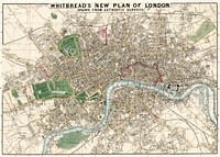
![Whitbread's new plan of London vintage illustration wall art print and poster design remix from original artwork.]() Whitbread's new plan of London vintage illustration wall art print and poster design remix from original artwork.
Whitbread's new plan of London vintage illustration wall art print and poster design remix from original artwork.![Whitbread's new plan of London : drawn from authentic surveys (1853) by J. Whitbread]() Whitbread's new plan of London : drawn from authentic surveys (1853) by J. Whitbread
Whitbread's new plan of London : drawn from authentic surveys (1853) by J. Whitbread![Sanborn Fire Insurance Map from Brooklyn, Kings County, New York (1888) by Sanborn Map Company. Original from Library of…]() Sanborn Fire Insurance Map from Brooklyn, Kings County, New York (1888) by Sanborn Map Company. Original from Library of…
Sanborn Fire Insurance Map from Brooklyn, Kings County, New York (1888) by Sanborn Map Company. Original from Library of…![An epitome of Sr. William Petty's large survey of Ireland divided into its 4 provinces & 32 counties ... and…]() An epitome of Sr. William Petty's large survey of Ireland divided into its 4 provinces & 32 counties ... and…
An epitome of Sr. William Petty's large survey of Ireland divided into its 4 provinces & 32 counties ... and…![Land surveying from Histoire de l'art égyptien (1878) by Émile Prisse d'Avennes. Original from The New York…]() Land surveying from Histoire de l'art égyptien (1878) by Émile Prisse d'Avennes. Original from The New York…
Land surveying from Histoire de l'art égyptien (1878) by Émile Prisse d'Avennes. Original from The New York…![A new and accurate map of the country for twenty five miles round the University of Oxford: exhibiting all the direct and…]() A new and accurate map of the country for twenty five miles round the University of Oxford: exhibiting all the direct and…
A new and accurate map of the country for twenty five miles round the University of Oxford: exhibiting all the direct and…![A new map of England Scotland and Ireland (1687), drawn by Robert Morden. Original public domain image from Digital…]() A new map of England Scotland and Ireland (1687), drawn by Robert Morden. Original public domain image from Digital…
A new map of England Scotland and Ireland (1687), drawn by Robert Morden. Original public domain image from Digital…![Planet poster template]() Planet poster template
Planet poster templateTrending Design
![Fortified City of Ranthambhor(ca. 1810–1818) by Generation of Bagta. Original from The MET Museum. Digitally enhanced…]() Fortified City of Ranthambhor(ca. 1810–1818) by Generation of Bagta. Original from The MET Museum. Digitally enhanced…
Fortified City of Ranthambhor(ca. 1810–1818) by Generation of Bagta. Original from The MET Museum. Digitally enhanced…![Map of Kyoto (1863) by Takebara Kahei. Original from The Beinecke Rare Book & Manuscript Library. Digitally enhanced by…]() Map of Kyoto (1863) by Takebara Kahei. Original from The Beinecke Rare Book & Manuscript Library. Digitally enhanced by…
Map of Kyoto (1863) by Takebara Kahei. Original from The Beinecke Rare Book & Manuscript Library. Digitally enhanced by…![Map of New York and vicinity (1875) by Matthew Dripps. Original from The Beinecke Rare Book & Manuscript Library. Digitally…]() Map of New York and vicinity (1875) by Matthew Dripps. Original from The Beinecke Rare Book & Manuscript Library. Digitally…
Map of New York and vicinity (1875) by Matthew Dripps. Original from The Beinecke Rare Book & Manuscript Library. Digitally…![Geography of the British Isles from ten different standpoints, with twenty-one maps (1886) by Thomas McLaren Davidson.…]() Geography of the British Isles from ten different standpoints, with twenty-one maps (1886) by Thomas McLaren Davidson.…
Geography of the British Isles from ten different standpoints, with twenty-one maps (1886) by Thomas McLaren Davidson.…![The First and Second Battles of Newbury and the Siege of Donnington Castle during the Civil War, A.D. 1643–1646 (1881)…]() The First and Second Battles of Newbury and the Siege of Donnington Castle during the Civil War, A.D. 1643–1646 (1881)…
The First and Second Battles of Newbury and the Siege of Donnington Castle during the Civil War, A.D. 1643–1646 (1881)…![Map of China (1848) by James Wyld. Original from The Beinecke Rare Book & Manuscript Library. Digitally enhanced by rawpixel.]() Map of China (1848) by James Wyld. Original from The Beinecke Rare Book & Manuscript Library. Digitally enhanced by rawpixel.
Map of China (1848) by James Wyld. Original from The Beinecke Rare Book & Manuscript Library. Digitally enhanced by rawpixel.![Eastern division of Paris: containing the Quartiers (1834) by W. B. Clarke and James Shury. Original from Library of…]() Eastern division of Paris: containing the Quartiers (1834) by W. B. Clarke and James Shury. Original from Library of…
Eastern division of Paris: containing the Quartiers (1834) by W. B. Clarke and James Shury. Original from Library of…![Beeton's Dictionary of Geography. A universal gazetteer. Illustrated by maps (1868) by Samuel Orchart Beeton. Original from…]() Beeton's Dictionary of Geography. A universal gazetteer. Illustrated by maps (1868) by Samuel Orchart Beeton. Original from…
Beeton's Dictionary of Geography. A universal gazetteer. Illustrated by maps (1868) by Samuel Orchart Beeton. Original from…![La Halle aux Blés, Street Plan (ca. 1810) by Pierre François Léonard Fontaine. Original from The MET…]() La Halle aux Blés, Street Plan (ca. 1810) by Pierre François Léonard Fontaine. Original from The MET…
La Halle aux Blés, Street Plan (ca. 1810) by Pierre François Léonard Fontaine. Original from The MET…![The City of New York: Longworth's Explanatory Map and Plan (1817) by David Longworth. Original from The MET Museum.…]() The City of New York: Longworth's Explanatory Map and Plan (1817) by David Longworth. Original from The MET Museum.…
The City of New York: Longworth's Explanatory Map and Plan (1817) by David Longworth. Original from The MET Museum.…![Map of Kyoto (1863) by Takebara Kahei. Original from The Beinecke Rare Book & Manuscript Library. Digitally enhanced by…]() Map of Kyoto (1863) by Takebara Kahei. Original from The Beinecke Rare Book & Manuscript Library. Digitally enhanced by…
Map of Kyoto (1863) by Takebara Kahei. Original from The Beinecke Rare Book & Manuscript Library. Digitally enhanced by…![Reduced ordnance map of London (1879) by J. Whitbread. Original from The Beinecke Rare Book & Manuscript Library. Digitally…]() Reduced ordnance map of London (1879) by J. Whitbread. Original from The Beinecke Rare Book & Manuscript Library. Digitally…
Reduced ordnance map of London (1879) by J. Whitbread. Original from The Beinecke Rare Book & Manuscript Library. Digitally…![Gazetteer of the British Isles, statistical and topographical by John Bartholomew (1887). Original from British Library.…]() Gazetteer of the British Isles, statistical and topographical by John Bartholomew (1887). Original from British Library.…
Gazetteer of the British Isles, statistical and topographical by John Bartholomew (1887). Original from British Library.…![Stanford's Compendium of Geography and Travel based on Hellwald's “Die Erde und ihre Völker” (1878) by Edward…]() Stanford's Compendium of Geography and Travel based on Hellwald's “Die Erde und ihre Völker” (1878) by Edward…
Stanford's Compendium of Geography and Travel based on Hellwald's “Die Erde und ihre Völker” (1878) by Edward…![Second Edition of The Imperial Gazetteer of India (1885) by William Wilson Hunter. Original from British Library. Digitally…]() Second Edition of The Imperial Gazetteer of India (1885) by William Wilson Hunter. Original from British Library. Digitally…
Second Edition of The Imperial Gazetteer of India (1885) by William Wilson Hunter. Original from British Library. Digitally…![Jardin Public, Champs Elysées byCharles Motte (1785–1836). Original from The MET Museum. Digitally enhanced by…]() Jardin Public, Champs Elysées byCharles Motte (1785–1836). Original from The MET Museum. Digitally enhanced by…
Jardin Public, Champs Elysées byCharles Motte (1785–1836). Original from The MET Museum. Digitally enhanced by…![The Story of Atlantis: a geographical, historical, and ethnological sketch. Illustrated by four maps of the world's…]() The Story of Atlantis: a geographical, historical, and ethnological sketch. Illustrated by four maps of the world's…
The Story of Atlantis: a geographical, historical, and ethnological sketch. Illustrated by four maps of the world's…![Orient Line Guide. Chapters for travellers by sea and by land (1885) by William John Loftie. Original from British Library.…]() Orient Line Guide. Chapters for travellers by sea and by land (1885) by William John Loftie. Original from British Library.…
Orient Line Guide. Chapters for travellers by sea and by land (1885) by William John Loftie. Original from British Library.…![The Commerce and Navigation of the Ancients in the Indian Ocean (1807) by William Vincent. Original from British Library.…]() The Commerce and Navigation of the Ancients in the Indian Ocean (1807) by William Vincent. Original from British Library.…
The Commerce and Navigation of the Ancients in the Indian Ocean (1807) by William Vincent. Original from British Library.…![A new map of England (1811) by John Cary. Original from The Beinecke Rare Book & Manuscript Library. Digitally enhanced by…]() A new map of England (1811) by John Cary. Original from The Beinecke Rare Book & Manuscript Library. Digitally enhanced by…
A new map of England (1811) by John Cary. Original from The Beinecke Rare Book & Manuscript Library. Digitally enhanced by…![Gazetteer of the British Isles, statistical and topographical (1887) by John Bartholomew. Original from British Library.…]() Gazetteer of the British Isles, statistical and topographical (1887) by John Bartholomew. Original from British Library.…
Gazetteer of the British Isles, statistical and topographical (1887) by John Bartholomew. Original from British Library.…![S. Beati Liebanensis mappam mundi ad exemplar ecclesiae Snacto Severi, quod nunc Parisiis asservatur, primum integram edidit…]() S. Beati Liebanensis mappam mundi ad exemplar ecclesiae Snacto Severi, quod nunc Parisiis asservatur, primum integram edidit…
S. Beati Liebanensis mappam mundi ad exemplar ecclesiae Snacto Severi, quod nunc Parisiis asservatur, primum integram edidit…![Eastern Hemisphere (1808) by C. Smith. Original from The Beinecke Rare Book & Manuscript Library. Digitally enhanced by…]() Eastern Hemisphere (1808) by C. Smith. Original from The Beinecke Rare Book & Manuscript Library. Digitally enhanced by…
Eastern Hemisphere (1808) by C. Smith. Original from The Beinecke Rare Book & Manuscript Library. Digitally enhanced by…![Map of France, Spain, and Portugal; Switzerland in cantons [inset]; Island of Corsica (1863) by Samuel Augustus Mitchell.…]() Map of France, Spain, and Portugal; Switzerland in cantons [inset]; Island of Corsica (1863) by Samuel Augustus Mitchell.…
Map of France, Spain, and Portugal; Switzerland in cantons [inset]; Island of Corsica (1863) by Samuel Augustus Mitchell.…![Noordpool (ca. 1869–1907) by Nijgh & Van Ditmar. Original from The Rijksmuseum. Digitally enhanced by rawpixel.]() Noordpool (ca. 1869–1907) by Nijgh & Van Ditmar. Original from The Rijksmuseum. Digitally enhanced by rawpixel.
Noordpool (ca. 1869–1907) by Nijgh & Van Ditmar. Original from The Rijksmuseum. Digitally enhanced by rawpixel.![Map of China by Katsushika Hokusai (1760–1849). Original from Yale University Art Gallery. Digitally enhanced by…]() Map of China by Katsushika Hokusai (1760–1849). Original from Yale University Art Gallery. Digitally enhanced by…
Map of China by Katsushika Hokusai (1760–1849). Original from Yale University Art Gallery. Digitally enhanced by…![Andrews's new and accurate travelling map of the roads of Scotland : shewing the distances between the towns &c …]() Andrews's new and accurate travelling map of the roads of Scotland : shewing the distances between the towns &c …
Andrews's new and accurate travelling map of the roads of Scotland : shewing the distances between the towns &c …![New twelve inch terrestrial globe (ca. 1891) by Rand McNally & Company. Original from Library of Congress. Digitally…]() New twelve inch terrestrial globe (ca. 1891) by Rand McNally & Company. Original from Library of Congress. Digitally…
New twelve inch terrestrial globe (ca. 1891) by Rand McNally & Company. Original from Library of Congress. Digitally…![Sea Pictures, drawn with pen and pencil (1882) by James Macaulay. Original from British Library. Digitally enhanced by…]() Sea Pictures, drawn with pen and pencil (1882) by James Macaulay. Original from British Library. Digitally enhanced by…
Sea Pictures, drawn with pen and pencil (1882) by James Macaulay. Original from British Library. Digitally enhanced by…![Geographische Naturkunde oder Grundzüge einer Allgemeinen Naturgeschichte der drei Reiche, mit physiognomischer Schilderung…]() Geographische Naturkunde oder Grundzüge einer Allgemeinen Naturgeschichte der drei Reiche, mit physiognomischer Schilderung…
Geographische Naturkunde oder Grundzüge einer Allgemeinen Naturgeschichte der drei Reiche, mit physiognomischer Schilderung…![World atlas from Voyeur's Checklist, General Notions Of Mathematical Geography, Physical Geography, Political Geography…]() World atlas from Voyeur's Checklist, General Notions Of Mathematical Geography, Physical Geography, Political Geography…
World atlas from Voyeur's Checklist, General Notions Of Mathematical Geography, Physical Geography, Political Geography…![Geographical-Statistical World Lexicon (1888) by Emil Metzger. Original from British Library. Digitally enhanced by rawpixel.]() Geographical-Statistical World Lexicon (1888) by Emil Metzger. Original from British Library. Digitally enhanced by rawpixel.
Geographical-Statistical World Lexicon (1888) by Emil Metzger. Original from British Library. Digitally enhanced by rawpixel.![Colton's Map of the World on Mercator's Projection (1858) by J.H. Colton & Co. Original from The Beinecke Rare Book &…]() Colton's Map of the World on Mercator's Projection (1858) by J.H. Colton & Co. Original from The Beinecke Rare Book &…
Colton's Map of the World on Mercator's Projection (1858) by J.H. Colton & Co. Original from The Beinecke Rare Book &…![Bankoku Jinbutsu no Dzu [Picture of the World and its People] (1825) by Imakajiyamachi Eijudo. Original from The Beinecke…]() Bankoku Jinbutsu no Dzu [Picture of the World and its People] (1825) by Imakajiyamachi Eijudo. Original from The Beinecke…
Bankoku Jinbutsu no Dzu [Picture of the World and its People] (1825) by Imakajiyamachi Eijudo. Original from The Beinecke…![A Moral and Political Sketch of the United States of North America with a note on Negro Slavery, Junius Redivivus (1833) by…]() A Moral and Political Sketch of the United States of North America with a note on Negro Slavery, Junius Redivivus (1833) by…
A Moral and Political Sketch of the United States of North America with a note on Negro Slavery, Junius Redivivus (1833) by…![The cartographic report by James Basire (1769-1822) of his majesty’s woods, forests, and land revenues. Original from…]() The cartographic report by James Basire (1769-1822) of his majesty’s woods, forests, and land revenues. Original from…
The cartographic report by James Basire (1769-1822) of his majesty’s woods, forests, and land revenues. Original from…![World atlas from Voyeur's Checklist, General Notions Of Mathematical Geography, Physical Geography, Political Geography…]() World atlas from Voyeur's Checklist, General Notions Of Mathematical Geography, Physical Geography, Political Geography…
World atlas from Voyeur's Checklist, General Notions Of Mathematical Geography, Physical Geography, Political Geography…![World atlas from The Practical Teaching of Geography. Atlas, Maps, Texts and Questionnaires... Elementary Course (1878).…]() World atlas from The Practical Teaching of Geography. Atlas, Maps, Texts and Questionnaires... Elementary Course (1878).…
World atlas from The Practical Teaching of Geography. Atlas, Maps, Texts and Questionnaires... Elementary Course (1878).…![World atlas from The Practical Teaching of Geography. Atlas, Maps, Texts and Questionnaires... Elementary Course (1878).…]() World atlas from The Practical Teaching of Geography. Atlas, Maps, Texts and Questionnaires... Elementary Course (1878).…
World atlas from The Practical Teaching of Geography. Atlas, Maps, Texts and Questionnaires... Elementary Course (1878).…![World atlas from Voyeur's Checklist, General Notions Of Mathematical Geography, Physical Geography, Political Geography…]() World atlas from Voyeur's Checklist, General Notions Of Mathematical Geography, Physical Geography, Political Geography…
World atlas from Voyeur's Checklist, General Notions Of Mathematical Geography, Physical Geography, Political Geography…![Southwark, London: map of the borough with key. Etching, 1755.]() Southwark, London: map of the borough with key. Etching, 1755.
Southwark, London: map of the borough with key. Etching, 1755.![Bowles's new pocket map of the world: laid down from the latest observations and comprehending the new discoveries to the…]() Bowles's new pocket map of the world: laid down from the latest observations and comprehending the new discoveries to the…
Bowles's new pocket map of the world: laid down from the latest observations and comprehending the new discoveries to the…![Johnson's Western Hemisphere [and] Johnson's Eastern Hemisphere (1866) by Johnson and Ward. Original from The Beinecke Rare…]() Johnson's Western Hemisphere [and] Johnson's Eastern Hemisphere (1866) by Johnson and Ward. Original from The Beinecke Rare…
Johnson's Western Hemisphere [and] Johnson's Eastern Hemisphere (1866) by Johnson and Ward. Original from The Beinecke Rare…![Die Erde. Eine allgemeine Erd- und Länderkunde, etc (1896) by Franz Heiderich. Original from British Library. Digitally…]() Die Erde. Eine allgemeine Erd- und Länderkunde, etc (1896) by Franz Heiderich. Original from British Library. Digitally…
Die Erde. Eine allgemeine Erd- und Länderkunde, etc (1896) by Franz Heiderich. Original from British Library. Digitally…![Map of South America, showing its political divisions; Map showing the proposed Atrato-inter-oceanic canalroutes, for…]() Map of South America, showing its political divisions; Map showing the proposed Atrato-inter-oceanic canalroutes, for…
Map of South America, showing its political divisions; Map showing the proposed Atrato-inter-oceanic canalroutes, for…![Map of New York and Vicinity (1869) by Matthew Dripps. Original from Library of Congress. Digitally enhanced by rawpixel.]() Map of New York and Vicinity (1869) by Matthew Dripps. Original from Library of Congress. Digitally enhanced by rawpixel.
Map of New York and Vicinity (1869) by Matthew Dripps. Original from Library of Congress. Digitally enhanced by rawpixel.![World atlas from The Practical Teaching of Geography. Atlas, Maps, Texts and Questionnaires... Elementary Course (1878).…]() World atlas from The Practical Teaching of Geography. Atlas, Maps, Texts and Questionnaires... Elementary Course (1878).…
World atlas from The Practical Teaching of Geography. Atlas, Maps, Texts and Questionnaires... Elementary Course (1878).…![World atlas from The Practical Teaching of Geography. Atlas, Maps, Texts and Questionnaires... Elementary Course (1878).…]() World atlas from The Practical Teaching of Geography. Atlas, Maps, Texts and Questionnaires... Elementary Course (1878).…
World atlas from The Practical Teaching of Geography. Atlas, Maps, Texts and Questionnaires... Elementary Course (1878).…![World atlas from Voyeur's Checklist, General Notions Of Mathematical Geography, Physical Geography, Political Geography…]() World atlas from Voyeur's Checklist, General Notions Of Mathematical Geography, Physical Geography, Political Geography…
World atlas from Voyeur's Checklist, General Notions Of Mathematical Geography, Physical Geography, Political Geography…![Bacon's standard map of Europe by George Washington Bacon (1830–1922). Original from Library of Congress. Digitally…]() Bacon's standard map of Europe by George Washington Bacon (1830–1922). Original from Library of Congress. Digitally…
Bacon's standard map of Europe by George Washington Bacon (1830–1922). Original from Library of Congress. Digitally…![A survey of Lake Champlain, including Lake George, Crown Point, and St. John : surveyed by order of His…]() A survey of Lake Champlain, including Lake George, Crown Point, and St. John : surveyed by order of His…
A survey of Lake Champlain, including Lake George, Crown Point, and St. John : surveyed by order of His…![Die beyden Halbkugeln der Erde (1807) by Schneider und Weigelsehen. Original from The Beinecke Rare Book & Manuscript…]() Die beyden Halbkugeln der Erde (1807) by Schneider und Weigelsehen. Original from The Beinecke Rare Book & Manuscript…
Die beyden Halbkugeln der Erde (1807) by Schneider und Weigelsehen. Original from The Beinecke Rare Book & Manuscript…![Map sampler made at Pleasent Valley Quaker Boarding School (1809) by Polly Platt. Original from The MET Museum. Digitally…]() Map sampler made at Pleasent Valley Quaker Boarding School (1809) by Polly Platt. Original from The MET Museum. Digitally…
Map sampler made at Pleasent Valley Quaker Boarding School (1809) by Polly Platt. Original from The MET Museum. Digitally…![The Voyages of Captain James Cook (1852) by James Cook. Original from British Library. Digitally enhanced by rawpixel.]() The Voyages of Captain James Cook (1852) by James Cook. Original from British Library. Digitally enhanced by rawpixel.
The Voyages of Captain James Cook (1852) by James Cook. Original from British Library. Digitally enhanced by rawpixel.![The island of Barbadoes : divided into its parishes, with the roads, paths, &c. according to an actual and…]() The island of Barbadoes : divided into its parishes, with the roads, paths, &c. according to an actual and…
The island of Barbadoes : divided into its parishes, with the roads, paths, &c. according to an actual and…![North Britain or Scotland divided into its counties : corrected from the best surveys & astronomical…]() North Britain or Scotland divided into its counties : corrected from the best surveys & astronomical…
North Britain or Scotland divided into its counties : corrected from the best surveys & astronomical…![World map from A System of Geography, for the use of Schools (1860) published by Sidney Edwards Morse. Original from the…]() World map from A System of Geography, for the use of Schools (1860) published by Sidney Edwards Morse. Original from the…
World map from A System of Geography, for the use of Schools (1860) published by Sidney Edwards Morse. Original from the…![World map from A System of Geography, for the use of Schools (1860) published by Sidney Edwards Morse. Original from the…]() World map from A System of Geography, for the use of Schools (1860) published by Sidney Edwards Morse. Original from the…
World map from A System of Geography, for the use of Schools (1860) published by Sidney Edwards Morse. Original from the…![A Cyclopedia of Geography, descriptive and physical, forming a new general gazetteer of the world and dictionary of…]() A Cyclopedia of Geography, descriptive and physical, forming a new general gazetteer of the world and dictionary of…
A Cyclopedia of Geography, descriptive and physical, forming a new general gazetteer of the world and dictionary of…![Route and Surveys of the Southern Journey Party, 1908–1909 (1909) by England: Royal Geographic Society. Original from…]() Route and Surveys of the Southern Journey Party, 1908–1909 (1909) by England: Royal Geographic Society. Original from…
Route and Surveys of the Southern Journey Party, 1908–1909 (1909) by England: Royal Geographic Society. Original from…![Map of the city of New York (ca. 1850) from Library of Congress Geography and Map Division Washington. Original from Library…]() Map of the city of New York (ca. 1850) from Library of Congress Geography and Map Division Washington. Original from Library…
Map of the city of New York (ca. 1850) from Library of Congress Geography and Map Division Washington. Original from Library…![A large and accurate map of the city of London : ichnographically describing all the streets, lanes, alleys, courts, yards…]() A large and accurate map of the city of London : ichnographically describing all the streets, lanes, alleys, courts, yards…
A large and accurate map of the city of London : ichnographically describing all the streets, lanes, alleys, courts, yards…![A general map of the southern British colonies in America comprehending North and South Carolina, Georgia, East…]() A general map of the southern British colonies in America comprehending North and South Carolina, Georgia, East…
A general map of the southern British colonies in America comprehending North and South Carolina, Georgia, East…![A new most accurate & complete map of all the direct and the principal crossroads in England and Wales…]() A new most accurate & complete map of all the direct and the principal crossroads in England and Wales…
A new most accurate & complete map of all the direct and the principal crossroads in England and Wales…![Philae Island (general plan of the ruins) from Histoire de l'art égyptien (1878) by Émile Prisse d'Avennes.…]() Philae Island (general plan of the ruins) from Histoire de l'art égyptien (1878) by Émile Prisse d'Avennes.…
Philae Island (general plan of the ruins) from Histoire de l'art égyptien (1878) by Émile Prisse d'Avennes.…![Historic Spanish Record of the Conquest, South Side of Inscription Rock, N.M. Geographical & Geological Explorations &…]() Historic Spanish Record of the Conquest, South Side of Inscription Rock, N.M. Geographical & Geological Explorations &…
Historic Spanish Record of the Conquest, South Side of Inscription Rock, N.M. Geographical & Geological Explorations &…![A chart of Montego Bay on the north west shore of the island of Jamaica : Port Antonio on the north east shore…]() A chart of Montego Bay on the north west shore of the island of Jamaica : Port Antonio on the north east shore…
A chart of Montego Bay on the north west shore of the island of Jamaica : Port Antonio on the north east shore…![Map of China and the adjacent countries : drawn from the latest surveys and other authentic documents ... / by William H.…]() Map of China and the adjacent countries : drawn from the latest surveys and other authentic documents ... / by William H.…
Map of China and the adjacent countries : drawn from the latest surveys and other authentic documents ... / by William H.…![Wall in the Grand Cañon, Colorado River by Timothy O'Sullivan]() Wall in the Grand Cañon, Colorado River by Timothy O'Sullivan
Wall in the Grand Cañon, Colorado River by Timothy O'Sullivan![Rock Carved by Drifting Sand, Below Fortification Rock, Arizona by Timothy O'Sullivan]() Rock Carved by Drifting Sand, Below Fortification Rock, Arizona by Timothy O'Sullivan
Rock Carved by Drifting Sand, Below Fortification Rock, Arizona by Timothy O'Sullivan![Water Rhyolites, Near Logan Springs, Nevada by Timothy O'Sullivan]() Water Rhyolites, Near Logan Springs, Nevada by Timothy O'Sullivan
Water Rhyolites, Near Logan Springs, Nevada by Timothy O'Sullivan![Alpine Lake, in the Sierra Nevada, California by Timothy O'Sullivan]() Alpine Lake, in the Sierra Nevada, California by Timothy O'Sullivan
Alpine Lake, in the Sierra Nevada, California by Timothy O'Sullivan![A new and most exact map of Europe described by N.I. Visscher and don into English and corrected according to I…]() A new and most exact map of Europe described by N.I. Visscher and don into English and corrected according to I…
A new and most exact map of Europe described by N.I. Visscher and don into English and corrected according to I…![The environs of London : reduced from an actual survey in 16 sheets / by the late John Rocque ... ; with new improvements to…]() The environs of London : reduced from an actual survey in 16 sheets / by the late John Rocque ... ; with new improvements to…
The environs of London : reduced from an actual survey in 16 sheets / by the late John Rocque ... ; with new improvements to…![A new & accurate map of the West Indies and the adjacent parts of North & South America]() A new & accurate map of the West Indies and the adjacent parts of North & South America
A new & accurate map of the West Indies and the adjacent parts of North & South America ![The natural shape of England with the names of rivers, seaports, sands, hills, moors, forrests, and many other…]() The natural shape of England with the names of rivers, seaports, sands, hills, moors, forrests, and many other…
The natural shape of England with the names of rivers, seaports, sands, hills, moors, forrests, and many other…![A chart of the sea coast of Brazil from Cape St. Augustine to the straights of Magellan, & in the South Sea, from the…]() A chart of the sea coast of Brazil from Cape St. Augustine to the straights of Magellan, & in the South Sea, from the…
A chart of the sea coast of Brazil from Cape St. Augustine to the straights of Magellan, & in the South Sea, from the…