The Rio Tinto river in southwestern Spain. Original from NASA. Digitally enhanced by rawpixel. https://www.rawpixel.com/image/441261/free-photo-image-spain-rio-tinto-satellite-climate-change Free Image from public domain license
View of the Salt Lake City, Utah area. Original from NASA. Digitally enhanced by rawpixel. https://www.rawpixel.com/image/441792/free-photo-image-map-nasa-utah Free Image from public domain license
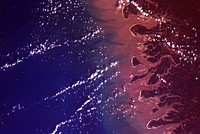
Oil from the Deepwater Horizon spill laps around the mouth of the Mississippi River Delta, May 24, 2010. Original from NASA.… https://www.rawpixel.com/image/440560/free-photo-image-nasa-snow-winter Free Image from public domain license
Early Melt on the Greenland Ice Sheet . Original from NASA . Digitally enhanced by rawpixel. https://www.rawpixel.com/image/440064/free-photo-image-ice-iceberg-nasa Free Image from public domain license
Lower Chesapeake Bay, VA, USA. Original from NASA. Digitally enhanced by rawpixel. https://www.rawpixel.com/image/441796/free-photo-image-maps-nasa-ocean Free Image from public domain license
Calcite Quarry, Michigan. Original from NASA. Digitally enhanced by rawpixel. https://www.rawpixel.com/image/440781/free-photo-image-maps-earth-aerial-north Free Image from public domain license
Parts of Galveston and Harris Counties and Galveston Bay and several communities in the Clear Lake area. Original from NASA.… https://www.rawpixel.com/image/440837/free-photo-image-map-usa-galveston Free Image from public domain license
Cosiguina Volcano, Nicaragua. Original from NASA. Digitally enhanced by rawpixel. https://www.rawpixel.com/image/440815/free-photo-image-nicaragua-pacific-ocean-map-nasa Free Image from public domain license
The Wilkins Ice Shelf on the western side of the Antarctic Peninsula. Original from NASA. Digitally enhanced by rawpixel. https://www.rawpixel.com/image/441236/free-photo-image-maps-snow-advanced-spaceborne-thermal-emission-and-reflection-radiometer-aster Free Image from public domain license
This spaceborne radar image shows the area just north of the city of Cairo, Egypt, where the Nile River splits into two main… https://www.rawpixel.com/image/441541/free-photo-image-nasa-map-city-maps Free Image from public domain license
Flood waters in Bangkok as the Ayutthaya River overflowed its banks. Original from NASA. Digitally enhanced by rawpixel. https://www.rawpixel.com/image/440502/free-photo-image-maps-background-flood Free Image from public domain license
Parts of he Kimberley region of Western Australia. Original from NASA. Digitally enhanced by rawpixel. https://www.rawpixel.com/image/440627/free-photo-image-australia-map-nasa Free Image from public domain license
Delhi, the second largest metropolis in India, with a population of 16 million. Original from NASA. Digitally enhanced by… https://www.rawpixel.com/image/441145/free-photo-image-map-satellite-maps-public-domain-high-resolution-landscape Free Image from public domain license
San Francisco and Bay Area, CA, USA. Original from NASA. Digitally enhanced by rawpixel. https://www.rawpixel.com/image/441579/free-photo-image-nasa-map-aerial Free Image from public domain license
The John F. Kennedy Space Center, America's spaceport, is located along Florida's eastern shore on Cape Canaveral. Original… https://www.rawpixel.com/image/441135/free-photo-image-florida-florida-maps-public-domain-map Free Image from public domain license
The Matusevich Glacier flows toward the coast of East Antarctica, pushing through a channel between the Lazarev Mountains… https://www.rawpixel.com/image/440265/free-photo-image-climate-change-aerial-photography-nasa Free Image from public domain license
NASA astronaut Scott Kelly captured this earth observation of the Caspian sea on July 27, 2015. Original from NASA.… https://www.rawpixel.com/image/440369/free-photo-image-nasa-aurora-earth Free Image from public domain license
The Soyuz TMA-16 spacecraft is featured in this image photographed by an Expedition 22 crew member on the International… https://www.rawpixel.com/image/440787/free-photo-image-nasa-astronaut-spacecraft Free Image from public domain license
Images of the Earth's land surface and surrounding coastal regions. Original from NASA. Digitally enhanced by rawpixel. https://www.rawpixel.com/image/440155/free-photo-image-nasa-map-seattle Free Image from public domain license
New image of the Earth at night is a composite assembled from data acquired by the Suomi National Polar-orbiting Partnership… https://www.rawpixel.com/image/440262/free-photo-image-map-world-background Free Image from public domain license
Guangxi Province in southeast China. Original from NASA. Digitally enhanced by rawpixel. https://www.rawpixel.com/image/440654/guangxi-provine-space-view Free Image from public domain license
The flooding from the Chao Phraya River, Thailand on Nov. 17, 2011. Original from NASA. Digitally enhanced by rawpixel. https://www.rawpixel.com/image/440511/free-photo-image-nasa-background-2011 Free Image from public domain license
Flooding from the Chao Phraya River, Thailand on Nov. 1, 2011. Original from NASA. Digitally enhanced by rawpixel. https://www.rawpixel.com/image/440508/free-photo-image-nasa-map-thailand Free Image from public domain license
The northernmost land in the world is located in Pearyland, Greenland. Original from NASA. Digitally enhanced by rawpixel. https://www.rawpixel.com/image/441198/free-photo-image-nasa-snow-greenland-nature Free Image from public domain license
Image taken by a new Earth-observing instrument installed on the international space station. Original from NASA. Digitally… https://www.rawpixel.com/image/440120/free-photo-image-nasa-panama-map Free Image from public domain license
Along with the plentiful harvest of crops in North America, one of the gifts of autumn is the gorgeous palette of colors… https://www.rawpixel.com/image/8718291/photo-image-leaves-public-domain-lines Free Image from public domain license
Some parts of the Earth are camera shy. Cloud cover seems to be ever-present around the equator and at high latitudes—where… https://www.rawpixel.com/image/8718262/photo-image-public-domain-mountain-ocean Free Image from public domain license
The first pass of Echo 1, America's first communications satellite, over the Goldstone Tracking Station in Pasadena… https://www.rawpixel.com/image/440672/communications-satellite Free Image from public domain license
Artist’s concept of the Orbiting Carbon Observatory. Original from NASA. Digitally enhanced by rawpixel. https://www.rawpixel.com/image/439979/free-photo-image-satellite-nasa-space-ship Free Image from public domain license
Typhoon Phanfone affecting Japan, on October 5, 2014. Original from NASA. Digitally enhanced by rawpixel. https://www.rawpixel.com/image/440100/free-photo-image-typhoon-nasa-japan Free Image from public domain license
View of the Soyuz TMA-11 on approach to the ISS. Original from NASA. Digitally enhanced by rawpixel. https://www.rawpixel.com/image/440838/free-photo-image-spaceship-satellite-astronaut Free Image from public domain license
View from the International Space Station shows the Soyuz TMA-12M spacecraft shortly before docking of the two orbiting… https://www.rawpixel.com/image/440288/free-photo-image-space-spacecraft-satellite Free Image from public domain license
Space X-4 Dragon commercial cargo approaches the ISS, 23 Sept. 2014. Original from NASA. Digitally enhanced by rawpixel. https://www.rawpixel.com/image/440297/free-photo-image-satellite-science-equipment-ocean Free Image from public domain license
The Soyuz TMA-15M spacecraft on the left attached to the Rassvet module on the Earth-facing port of the Russian segment of… https://www.rawpixel.com/image/440284/free-photo-image-satellite-earth-nasa Free Image from public domain license
Earth observation of North America tweeted out to social media fans of NASA astronaut Terry Virts who was on a 6 month… https://www.rawpixel.com/image/440285/free-photo-image-iss-earth-satellite-observation Free Image from public domain license
Space X-4 Dragon commercial cargo approaches the ISS, 23 Sept. 2014. Original from NASA . Digitally enhanced by rawpixel. https://www.rawpixel.com/image/440300/free-photo-image-spacex-nasa-aerospace Free Image from public domain license
The gantry rolls back at Space Launch Complex 2 in preparation for the liftoff of the Joint Polar Satellite System-1… https://www.rawpixel.com/image/440585/free-photo-image-nasa-america-americas-public-domain Free Image from public domain license
Following the postponement on Nov. 14, 2017, the countdown is again underway for the liftoff of the Joint Polar Satellite… https://www.rawpixel.com/image/440582/free-photo-image-nasa-rocket-america Free Image from public domain license
At NASA Kennedy Space Center's Visitor Complex, Star Trek memorabilia is being displayed. Original from NASA . Digitally… https://www.rawpixel.com/image/441014/free-photo-image-spaceship-star-trek-galaxy Free Image from public domain license
Cornell University, Infrared Interferometer mission directors console. Original from NASA. Digitally enhanced by rawpixel. https://www.rawpixel.com/image/440063/free-photo-image-nasa-room-technology Free Image from public domain license
Full Mir over New Zealand, from the space shuttle Atlantis, Russia's Mir Space Station. Original from NASA. Digitally… https://www.rawpixel.com/image/441571/free-photo-image-new-zealand-maps-satellite-public-domain Free Image from public domain license
View of the Himalaya Mountain Range in the India-Nepal-Tibet border area. Original from NASA. Digitally enhanced by rawpixel. https://www.rawpixel.com/image/441723/free-photo-image-india-maps-mountain Free Image from public domain license
The central coastal area of Peru as seen from the Gemini-9A spacecraft. Original from NASA. Digitally enhanced by rawpixel https://www.rawpixel.com/image/441726/free-photo-image-peru-maps-satellite Free Image from public domain license
MODIS on the Aqua satellite captured this stunning view of Japans four largest islands on February 20, 2004. Original from… https://www.rawpixel.com/image/440157/free-photo-image-maps-satellite-public-domain Free Image from public domain license
Plankton blooms in the Falkland Current east of the Argentinian coast. Original from NASA. Digitally enhanced by rawpixel. https://www.rawpixel.com/image/441573/free-photo-image-plankton-satellite-maps Free Image from public domain license
Los Angeles and vicinity seen from space on May 4, 2001. Original from NASA. Digitally enhanced by rawpixel. https://www.rawpixel.com/image/440540/free-photo-image-topography-los-angeles-map-radar Free Image from public domain license
Island of Hawaii, State of Hawaii seen from Skylab. Original from NASA. Digitally enhanced by rawpixel. https://www.rawpixel.com/image/441611/free-photo-image-hawaii-volcano-island-maps Free Image from public domain license
The Expedition 32 crew onboard the International Space Station, flying an altitude of approximately 240 miles, recorded a… https://www.rawpixel.com/image/440248/the-international-space-station Free Image from public domain license
This picture of the International Space Station was photographed from the space shuttle Atlantis in the early hours of July… https://www.rawpixel.com/image/441358/free-photo-image-satellite-station-nasa Free Image from public domain license
This picture of the International Space Station was photographed from the space shuttle Atlantis in the early hours of July… https://www.rawpixel.com/image/441348/free-photo-image-iss-satellite-shuttle-atlantis Free Image from public domain license
Image showing the International Space Station on the STS-135 mission's third day in Earth orbit. Original from NASA.… https://www.rawpixel.com/image/441349/free-photo-image-iss-satellite-spacecraft Free Image from public domain license
Mackenzie Bay, Antarctica and the ice shelf on February 12, 2012., Original from NASA. Digitally enhanced by rawpixel. https://www.rawpixel.com/image/440206/mackenzie-bay-antarctica-space-view Free Image from public domain license
The International Space Station backdropped by Earth’s horizon and the blackness of space. Original from NASA .… https://www.rawpixel.com/image/418660/the-international-space-station Free Image from public domain license
In Orbiter Processing Facility-2 at NASA's Kennedy Space Center in Florida, the flight deck of space shuttle Atlantis is lit… https://www.rawpixel.com/image/441087/free-photo-image-nasa-cockpit-kennedy-space-center Free Image from public domain license
In Orbiter Processing Facility-2 at NASA's Kennedy Space Center in Florida, the flight deck of space shuttle Atlantis is lit… https://www.rawpixel.com/image/441136/free-photo-image-cockpit-spaceship-technology Free Image from public domain license
In Orbiter Processing Facility-2 at NASA's Kennedy Space Center in Florida, the flight deck of space shuttle Atlantis is lit… https://www.rawpixel.com/image/441101/free-photo-image-space-shuttle-spaceship-cockpit Free Image from public domain license
In Orbiter Processing Facility-2 at NASA's Kennedy Space Center in Florida, the flight deck of space shuttle Atlantis is lit… https://www.rawpixel.com/image/441120/free-photo-image-cockpit-shuttle-atlantis-tech-support Free Image from public domain license
In Orbiter Processing Facility-2 at NASA's Kennedy Space Center in Florida, the flight deck of space shuttle Atlantis is lit… https://www.rawpixel.com/image/441099/free-photo-image-nasa-cockpit-spaceship Free Image from public domain license
On August 22, 2014 the Moderate Resolution Imaging Spectroradiometer aboard NASA’s Terra satellite captured a true… https://www.rawpixel.com/image/440172/free-photo-image-nasa-iceland-satellite Free Image from public domain license
Hurricane Gonzalo's northern quadrant over Bermuda. Original from NASA. Digitally enhanced by rawpixel. https://www.rawpixel.com/image/440115/free-photo-image-hurricane-nasa-climate-change Free Image from public domain license
The Soyuz TMA-19 spacecraft departs the International Space Station on Nov. 25, 2010. Original from NASA . Digitally… https://www.rawpixel.com/image/440803/free-photo-image-satellite-nasa-spaceship Free Image from public domain license
The Soyuz TMA-19 spacecraft departs the International Space Station on Nov. 25, 2010. Original from NASA. Digitally enhanced… https://www.rawpixel.com/image/440845/free-photo-image-satellite-orbital-spacecraft Free Image from public domain license
Earth observations taken during STS-77 mission. Original from NASA. Digitally enhanced by rawpixel. https://www.rawpixel.com/image/441615/free-photo-image-nasa-maps-ocean Free Image from public domain license
Remote sensing of ocean color in the Yellow Sea. Original from NASA. Digitally enhanced by rawpixel. https://www.rawpixel.com/image/440150/free-photo-image-chinese-maps-nasa Free Image from public domain license
Earth observations taken from Space Shuttle Columbia during STS-93 mission. Original from NASA. Digitally enhanced by… https://www.rawpixel.com/image/441583/free-photo-image-fire-rainforest-climate-change Free Image from public domain license
Sediment Transforms Lake Michigan, Original from NASA. Digitally enhanced by rawpixel. https://www.rawpixel.com/image/440733/free-photo-image-coastline-maps-public-domain Free Image from public domain license
The Ouachita Mountains in southeast Oklahoma. Original from NASA. Digitally enhanced by rawpixel. https://www.rawpixel.com/image/441267/free-photo-image-nasa-map-oklahoma Free Image from public domain license
View of Melbourne, Australia as seen from the Skylab space station. Original from NASA. Digitally enhanced by rawpixel. https://www.rawpixel.com/image/441570/free-photo-image-melbourne-australian-australia Free Image from public domain license
The heart of the NASA Center for Climate Simulation (NCCS) is the “Discover” supercomputer. Original from NASA.… https://www.rawpixel.com/image/440279/free-photo-image-data-center-database Free Image from public domain license
Earth observations of Houston taken by STS-115 crew member. Original from NASA. Digitally enhanced by rawpixel. https://www.rawpixel.com/image/441285/free-photo-image-stadium-satellite-view-historical-maps Free Image from public domain license
The Olympic National Park has to be one of America’s most diverse national park landscapes. Original from NASA.… https://www.rawpixel.com/image/440091/free-photo-image-satellite-nasa-olympic-national-park Free Image from public domain license
Phytoplankton bloom off Newfoundland. Original from NASA. Digitally enhanced by rawpixel. https://www.rawpixel.com/image/440201/phytoplankton-bloom-off-newfoundland Free Image from public domain license
Southwestern US, with Las Vegas, NV in foreground, June 27, 1965. Original from NASA. Digitally enhanced by rawpixel. https://www.rawpixel.com/image/441657/free-photo-image-nasa-satellite-view-apollo Free Image from public domain license
NASA and NOAA satellites are studying the triple tropical tempests that are now romping through the Eastern Pacific Ocean.… https://www.rawpixel.com/image/440125/free-photo-image-earth-planet-world-pacific-ocean Free Image from public domain license
In Orbiter Processing Facility Bay 2 at NASA’s Kennedy Space Center in Florida, the space shuttle Endeavour's flight… https://www.rawpixel.com/image/440367/free-photo-image-cockpit-nasa-astronomy Free Image from public domain license
The upper levels of the launch gantry, surrounding the United Launch Alliance Delta II rocket at Vandenberg Air Force Base… https://www.rawpixel.com/image/439969/free-photo-image-american-flag-air-force-americas-public-domain Free Image from public domain license
A close-up view of a portion of the unpiloted Japanese H-II Transfer Vehicle as it arrives at the International Space… https://www.rawpixel.com/image/440844/free-photo-image-nasa-aerospace-asian Free Image from public domain license
The Soyuz TMA-19 spacecraft departs the International Space Station on Nov. 25, 2010. Original from NASA . Digitally… https://www.rawpixel.com/image/440806/spacecraft-space Free Image from public domain license
Acadia National Park is one of the most visited parks in America. Original from NASA. Digitally enhanced by rawpixel. https://www.rawpixel.com/image/440092/free-photo-image-map-nasa-world Free Image from public domain license
Earth observations of Argentina and Chile was among several of South America. Original from NASA. Digitally enhanced by… https://www.rawpixel.com/image/441601/free-photo-image-argentina-nasa-climate-change Free Image from public domain license
CH-47 (NASA-737) Control Panel and Cockpit. Original from NASA. Digitally enhanced by rawpixel. https://www.rawpixel.com/image/439980/free-photo-image-nasa-cockpit-invasion Free Image from public domain license
View of Florence, Italy area from the Skylab. Original from NASA. Digitally enhanced by rawpixel. https://www.rawpixel.com/image/441546/free-photo-image-nasa-map-florence Free Image from public domain license
The United Launch Alliance Delta II rocket with the Soil Moisture Active Passive satellite aboard, at the Space Launch… https://www.rawpixel.com/image/440455/free-photo-image-sunset-america-americas-public-domain Free Image from public domain license
The ice of a piedmont glacier spills from a steep valley onto a relatively flat plain. Malaspina Glacier, Alaska. Original… https://www.rawpixel.com/image/440088/free-photo-image-nasa-map-piedmont Free Image from public domain license
NASA Blue Marble 2007 West captured by the Moderate Resolution Imaging Spectroradiometer on NASA’s Terra satellite in… https://www.rawpixel.com/image/440232/the-planet-earth Free Image from public domain license
New NASA laser technology reveals how ice measures up. Original from NASA. Digitally enhanced by rawpixel. https://www.rawpixel.com/image/440185/free-photo-image-greenland-snow-arctic-ocean Free Image from public domain license
NASA:Saturn, Pad 34, blockhouse interiors. Original from NASA. Digitally enhanced by rawpixel. https://www.rawpixel.com/image/441686/free-photo-image-control-room-nasa-interior Free Image from public domain license
Clear shot of every parcel of Earth’s land surface and islands in nighttime view in visible light. A composite of… https://www.rawpixel.com/image/440239/earth-night Free Image from public domain license
Akpatok Island in Ungava Bay in northern Quebec, Canada. Original from NASA. Digitally enhanced by rawpixel. https://www.rawpixel.com/image/440234/free-photo-image-water-maps-ice Free Image from public domain license
Puffing Sun Gives Birth To Reluctant Eruption. Original from NASA. Digitally enhanced by rawpixel. https://www.rawpixel.com/image/440147/free-photo-image-sun-space-radiation Free Image from public domain license
This picture of the International Space Station was photographed from the space shuttle Atlantis in the early hours of July… https://www.rawpixel.com/image/441356/free-photo-image-iss-space-station-international Free Image from public domain license
GK Persei or Nova Persei 1901 discovered 21 February by Scottish clergyman Thomas David Anderson. It was a bright nova… https://www.rawpixel.com/image/440096/bright-nova Free Image from public domain license
NASA-NOAA's Suomi NPP Satellite Gets Colorful Look at Hurricane Blanca. Original from NASA. Digitally enhanced by rawpixel. https://www.rawpixel.com/image/440152/free-photo-image-hurricane-nasa-storm Free Image from public domain license
On July 20, the U.S. Coast Guard Cutter Healy steamed south in the Arctic Ocean toward the edge of the sea ice. Original… https://www.rawpixel.com/image/440132/icy-sea Free Image from public domain license
C-141 KAO (NASA-714) Monitoring Systems mission control center. Original from NASA. Digitally enhanced by rawpixel. https://www.rawpixel.com/image/440001/free-photo-image-control-room-shuttle-controls Free Image from public domain license