Vintage universal atlas illustration wall art print and poster design remix from original artwork. https://www.rawpixel.com/image/2267325/premium-illustration-image-map-vintage-ship View license
Britannia insula quae duo regna continet Angliam et Scotiam cum Hibernia adiacente. https://www.rawpixel.com/image/9370418/image-art-vintage-public-domain Free Image from public domain license
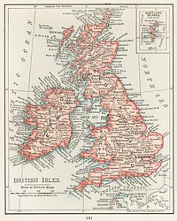
Gazetteer of the British Isles, statistical and topographical (1887) by John Bartholomew. Original from British Library.… https://www.rawpixel.com/image/2037054/gazetteer-the-british-isles Free Image from public domain license
Route and Surveys of the Southern Journey Party, 1908–1909 (1909) by England: Royal Geographic Society. Original from… https://www.rawpixel.com/image/2041987/route-and-surveys-the-southern-journey Free Image from public domain license
British Islands approximate positions of minefields (1918) by William Rea Furlong. Original from Library of Congress.… https://www.rawpixel.com/image/2041328/british-islands-positions-minefields Free Image from public domain license
Western Hemisphere, World Atlas by Rand, McNally and Co. (1908) Digitally enhanced from our own original chromolithograph. https://www.rawpixel.com/image/428189/map-the-western-hemisphere Free Image from public domain license
A general map of Great Britain and Ireland : with part of Germany, Holland, Flanders, France &c. agreeable to… https://www.rawpixel.com/image/8908138/image-vintage-public-domain-notes Free Image from public domain license
Amerique du Nord from Atlas Universel by Arthème Fayard, pseudonyme F. de la Brugere (1836-1895), published in 1878… https://www.rawpixel.com/image/428218/detailed-map-the-western-world Free Image from public domain license
Annual Rainfall Distribution. Digitally enhanced from our own original plate. https://www.rawpixel.com/image/431512/free-illustration-image-map-world-vintage-paper Free Image from public domain license
Charte der vereinigten Königreiche Grosbritanien und Ireland : nach den neuesten Berichtigungen und… https://www.rawpixel.com/image/8905454/image-faces-vintage-public-domain Free Image from public domain license
Vintage European style atlas engraving. Original from the British Library. Digitally enhanced by rawpixel. https://www.rawpixel.com/image/556303/vintage-globe-stand-illustration Free Image from public domain license
Vintage European style atlas engraving from Chambers's Alternative Geography Readers byWilliam Chambers (1898). Original… https://www.rawpixel.com/image/556372/vintage-globe-stand-illustration Free Image from public domain license
Vintage European style atlas engraving from Chambers's Alternative Geography Readers by William Chambers (1898). Original… https://www.rawpixel.com/image/556346/vintage-globe-stand-illustration Free Image from public domain license
John Speede's British Isle Map (1770). Original public domain image from The Smithsonian Institution. https://www.rawpixel.com/image/8627248/image-art-vintage-public-domain Free Image from public domain license
Geology, The Principal Features of Europe Geological. Digitally enhanced from our own original edition of A history of the… https://www.rawpixel.com/image/411837/free-illustration-image-map-europe-rome Free Image from public domain license
A new map of Ireland divided into its provinces, counties and baronies, wherein are distinguished the… https://www.rawpixel.com/image/8905696/image-vintage-hand-public-domain Free Image from public domain license
Bacon's standard map of Europe by George Washington Bacon (1830–1922). Original from Library of Congress. Digitally… https://www.rawpixel.com/image/2039067/bacons-standard-map-europe Free Image from public domain license
Vintage European style atlas engraving. Original from the British Library. Digitally enhanced by rawpixel. https://www.rawpixel.com/image/556293/vintage-globe-stand-illustration Free Image from public domain license
World atlas from Voyeur's Checklist, General Notions Of Mathematical Geography, Physical Geography, Political Geography… https://www.rawpixel.com/image/572710/the-world-map Free Image from public domain license
A new map of England (1811) by John Cary. Original from The Beinecke Rare Book & Manuscript Library. Digitally enhanced by… https://www.rawpixel.com/image/2041314/new-map-england Free Image from public domain license
A Burmese map of the world, showing traces of Medieval European map-making from The thirty-seven nats : a phase of spirit… https://www.rawpixel.com/image/327861/free-illustration-image-map-medieval-hindu Free Image from public domain license
World atlas from Voyeur's Checklist, General Notions Of Mathematical Geography, Physical Geography, Political Geography… https://www.rawpixel.com/image/572510/the-world-map Free Image from public domain license
World atlas from The Practical Teaching of Geography. Atlas, Maps, Texts and Questionnaires... Elementary Course (1878).… https://www.rawpixel.com/image/572622/the-globe-vintage-drawing Free Image from public domain license
Missionary map of the world showing prevailing religions of its various nations and the central stations of all Protestant… https://www.rawpixel.com/image/8627195/image-art-world-maps-vintage Free Image from public domain license
World atlas from Voyeur's Checklist, General Notions Of Mathematical Geography, Physical Geography, Political Geography… https://www.rawpixel.com/image/572760/the-world-map Free Image from public domain license
World atlas from The Practical Teaching of Geography. Atlas, Maps, Texts and Questionnaires... Elementary Course (1878).… https://www.rawpixel.com/image/572662/the-globe-vintage-drawing Free Image from public domain license
World atlas from Voyeur's Checklist, General Notions Of Mathematical Geography, Physical Geography, Political Geography… https://www.rawpixel.com/image/572425/the-world-map Free Image from public domain license
World map from A System of Geography, for the use of Schools (1860) published by Sidney Edwards Morse. Original from the… https://www.rawpixel.com/image/571383/antique-world-map-drawing Free Image from public domain license
World atlas from The Practical Teaching of Geography. Atlas, Maps, Texts and Questionnaires... Elementary Course (1878).… https://www.rawpixel.com/image/572726/the-globe-vintage-drawing Free Image from public domain license
World atlas from The Practical Teaching of Geography. Atlas, Maps, Texts and Questionnaires... Elementary Course (1878).… https://www.rawpixel.com/image/571993/the-globe-vintage-drawing Free Image from public domain license
Imperial Federation, map of the world showing the extent of the British Empire in 1886 https://www.rawpixel.com/image/8905493/image-art-tiger-vintage Free Image from public domain license
Illustration of riding the stang from The Costume of Yorkshire (1814) by George Walker (1781-1856). Original from The New… https://www.rawpixel.com/image/328151/free-illustration-image-people-19th-century-ancient Free Image from public domain license
Illustration of line swinglers from The Costume of Yorkshire (1814) by George Walker (1781-1856). Original from The New York… https://www.rawpixel.com/image/328162/free-illustration-image-people-line-europe Free Image from public domain license
Illustration of rape threshing from The Costume of Yorkshire (1814) by George Walker (1781-1856). Original from The New York… https://www.rawpixel.com/image/328170/free-illustration-image-rape-vintage-public-domain Free Image from public domain license
Illustration of teasel field from The Costume of Yorkshire (1814) by George Walker (1781-1856). Original from The New York… https://www.rawpixel.com/image/328159/free-illustration-image-field-people Free Image from public domain license
Illustration of the cloth dresser from The Costume of Yorkshire (1814) by George Walker (1781-1856). Original from The New… https://www.rawpixel.com/image/328141/free-illustration-image-europe-old-people-vintage Free Image from public domain license
Illustration of Sheffield cutler from The Costume of Yorkshire (1814) by George Walker (1781-1856). Original from The New… https://www.rawpixel.com/image/328148/free-illustration-image-work-england-vintage-century Free Image from public domain license
Illustration of peat cart from The Costume of Yorkshire (1814) by George Walker (1781-1856). Original from The New York… https://www.rawpixel.com/image/328153/free-illustration-image-ancient-person-peat-sketch Free Image from public domain license
Illustration of sea bathing from The Costume of Yorkshire (1814) by George Walker (1781-1856). Original from The New York… https://www.rawpixel.com/image/328138/free-illustration-image-british-sea-sketch Free Image from public domain license
Illustration of whalebone scrapers from The Costume of Yorkshire (1814) by George Walker (1781-1856). Original from The New… https://www.rawpixel.com/image/328139/free-illustration-image-england-people-sketch Free Image from public domain license
Illustration of nor and spell from The Costume of Yorkshire (1814) by George Walker (1781-1856). Original from The New York… https://www.rawpixel.com/image/328161/free-illustration-image-walker-people-ancient Free Image from public domain license
Illustration of the ruddle pit from The Costume of Yorkshire (1814) by George Walker (1781-1856). Original from The New York… https://www.rawpixel.com/image/328150/free-illustration-image-pit-europe-old-people Free Image from public domain license
Illustration of the fool plough from The Costume of Yorkshire (1814) by George Walker (1781-1856). Original from The New… https://www.rawpixel.com/image/328152/free-illustration-image-fool-britain Free Image from public domain license
Illustration of the preemer boy from The Costume of Yorkshire (1814) by George Walker (1781-1856). Original from The New… https://www.rawpixel.com/image/328165/free-illustration-image-people-england-19th-century Free Image from public domain license
Illustration of alum works from The Costume of Yorkshire (1814) by George Walker (1781-1856). Original from The New York… https://www.rawpixel.com/image/328155/free-illustration-image-vintage-british-history-work Free Image from public domain license
Illustration of East York militia from The Costume of Yorkshire (1814) by George Walker (1781-1856). Original from The New… https://www.rawpixel.com/image/328164/free-illustration-image-yorkshire-19th-century-ancient Free Image from public domain license
Illustration of the collier from The Costume of Yorkshire (1814) by George Walker (1781-1856). This image features also… https://www.rawpixel.com/image/328134/collier-the-mine Free Image from public domain license
Illustration of lowkers from The Costume of Yorkshire (1814) by George Walker (1781-1856). Original from The New York Public… https://www.rawpixel.com/image/328143/free-illustration-image-people-clothing-english Free Image from public domain license
Illustration of factory children from The Costume of Yorkshire (1814) by George Walker (1781-1856). Original from The New… https://www.rawpixel.com/image/328167/free-illustration-image-people-drawings-factory-clothes-childrens Free Image from public domain license
Illustration of North York militia from The Costume of Yorkshire (1814) by George Walker (1781-1856). Original from The New… https://www.rawpixel.com/image/328144/free-illustration-image-19th-century-ancient-antique Free Image from public domain license
Illustration of the cloth hall from The Costume of Yorkshire (1814) by George Walker (1781-1856). Original from The New York… https://www.rawpixel.com/image/328163/free-illustration-image-people-work-clothing-dress Free Image from public domain license
Illustration of bishop blaize from The Costume of Yorkshire (1814) by George Walker (1781-1856). Original from The New York… https://www.rawpixel.com/image/328146/free-illustration-image-history-british-people Free Image from public domain license
Illustration of moor guide from The Costume of Yorkshire (1814) by George Walker (1781-1856). Original from The New York… https://www.rawpixel.com/image/328172/free-illustration-image-public-domain-george-walker-19th-century Free Image from public domain license
North Britain or Scotland divided into its counties : corrected from the best surveys & astronomical… https://www.rawpixel.com/image/8907353/image-vintage-hand-public-domain Free Image from public domain license
World map from A System of Geography, for the use of Schools (1860) published by Sidney Edwards Morse. Original from the… https://www.rawpixel.com/image/571364/antique-world-map-drawing Free Image from public domain license
Illustration of hawking from The Costume of Yorkshire (1814) by George Walker (1781-1856). Original from The New York Public… https://www.rawpixel.com/image/328160/free-illustration-image-vintage-horse-england-hawk Free Image from public domain license
Illustration of the horse dealer from The Costume of Yorkshire (1814) by George Walker (1781-1856). Original from The New… https://www.rawpixel.com/image/328131/free-illustration-image-horses-people-19th-century Free Image from public domain license
Illustration of the horse dealer from The Costume of Yorkshire (1814) by George Walker (1781-1856). Original from The New… https://www.rawpixel.com/image/328133/free-illustration-image-horse-england-art Free Image from public domain license
Portolan atlas of the Mediterranean Sea, western Europe, and the northwest coast of Africa: Central Mediterranean (ca. 1590)… https://www.rawpixel.com/image/2041317/central-mediterranean-map Free Image from public domain license
Illustration of grenadier or the first West York militia from The Costume of Yorkshire (1814) by George Walker (1781-1856).… https://www.rawpixel.com/image/328149/free-illustration-image-public-domain-british-vintage-england Free Image from public domain license
Illustration of stone breakers on the road from The Costume of Yorkshire (1814) by George Walker (1781-1856). Original from… https://www.rawpixel.com/image/328147/free-illustration-image-road-ancient-people-art Free Image from public domain license
Illustration of thirty-third regiment from The Costume of Yorkshire (1814) by George Walker (1781-1856). Original from The… https://www.rawpixel.com/image/328142/free-illustration-image-ancient-century-england-people Free Image from public domain license
North America, and the West Indies : a new map, wherin the British Empire and its limits, according to the definitive treaty… https://www.rawpixel.com/image/9203576/photo-image-vintage-public-domain-maps Free Image from public domain license
River Bull-head from The Natural History of British Fishes (1802) by Edward Donovan. Original from the New York Public… https://www.rawpixel.com/image/431241/free-illustration-image-freshwater-fish-marine-life Free Image from public domain license
Portolan atlas of the Mediterranean Sea, western Europe, and the northwest coast of Africa: Eastern Mediterranean (ca. 1590)… https://www.rawpixel.com/image/2041316/eastern-mediterranean-map Free Image from public domain license
Illustration of leech finders from The Costume of Yorkshire (1814) by George Walker (1781-1856). Original from The New York… https://www.rawpixel.com/image/328166/free-illustration-image-19th-century-english-leech Free Image from public domain license
European Atherine from The Natural History of British Fishes (1802) by Edward Donovan. Original from the New York Public… https://www.rawpixel.com/image/431371/free-illustration-image-1800s-public-domain-animal-animals Free Image from public domain license
The European sea sturgeon from The Natural History of British Fishes (1802) by Edward Donovan. Original from the New York… https://www.rawpixel.com/image/431221/free-illustration-image-illustration-sea-animals-white-public-domain-natural-history-british-fishes Free Image from public domain license
Barbel from The Natural History of British Fishes (1802) by Edward Donovan. Original from the New York Public Library.… https://www.rawpixel.com/image/431298/free-illustration-image-vintage-fish-drawings-1800s-public-domain-animal Free Image from public domain license
European flounder from The Natural History of British Fishes (1802) by Edward Donovan. Original from the New York Public… https://www.rawpixel.com/image/431380/free-illustration-image-sea-white-public-domain-life Free Image from public domain license
Hake from The Natural History of British Fishes (1802) by Edward Donovan. Original from the New York Public Library.… https://www.rawpixel.com/image/431304/free-illustration-image-freshwater-fish-merluccius Free Image from public domain license
Illustration of the east riding or wolds waggon from The Costume of Yorkshire (1814) by George Walker (1781-1856). Original… https://www.rawpixel.com/image/328171/free-illustration-image-people-history-wold-england Free Image from public domain license
Illustration of the milk boy from The Costume of Yorkshire (1814) by George Walker (1781-1856). Original from The New York… https://www.rawpixel.com/image/328169/free-illustration-image-england-milk-vintage-people Free Image from public domain license
Illustration of cloth makers from The Costume of Yorkshire (1814) by George Walker (1781-1856). Original from The New York… https://www.rawpixel.com/image/328135/free-illustration-image-vintage-horse-people-ancient Free Image from public domain license
Illustration of farmers from The Costume of Yorkshire (1814) by George Walker (1781-1856). Original from The New York Public… https://www.rawpixel.com/image/328140/free-illustration-image-england-vintage-horse-sketch Free Image from public domain license
Illustration of jockies from The Costume of Yorkshire (1814) by George Walker (1781-1856). Original from The New York Public… https://www.rawpixel.com/image/328158/free-illustration-image-jockey-ancient-british-people-old Free Image from public domain license
Map of Zeppelin and aeroplane bombs on London. From: World War I photograph album (1919) by Herbert Green. Original from… https://www.rawpixel.com/image/2038866/map-zeppelin-and-aeroplane-bombs Free Image from public domain license
Spain: map. Coloured engraving J. van Lugtenburg, ca. 1720, after G. de L'Isle. https://www.rawpixel.com/image/13961746/spain-map-coloured-engraving-van-lugtenburg-ca-1720-after-lisle Free Image from public domain license
Portolan atlas of the Mediterranean Sea, western Europe, and the northwest coast of Africa: World map drawn on an oval… https://www.rawpixel.com/image/2041320/world-map-drawn-oval-projection Free Image from public domain license
New index geological map of the British Isles, and adjacent coast of France constructed from published… https://www.rawpixel.com/image/8905675/image-vintage-public-domain-notes Free Image from public domain license
Les Isles Britanniques : qui comprennent les Royaumes d'Angleterre, d'Ecosse et d'Irlande https://www.rawpixel.com/image/8906413/image-vintage-public-domain-map Free Image from public domain license
The British Isles where the Kingdoms of England are (1730), vintage map illustration by Guillaume de L'Isle. Original public… https://www.rawpixel.com/image/9425651/image-art-vintage-illustration Free Image from public domain license
The British lion from Un-Natural History Not Taught In Bored Schools, etc published by Simpkin, Marshall & Co. (1883).… https://www.rawpixel.com/image/572559/british-lion-vintage-drawing Free Image from public domain license
London buildings from London, illustrated. A complete guide to the leading hotels, places of amusement ... Also a directory… https://www.rawpixel.com/image/573150/majestic-london-architecture Free Image from public domain license
Illustration of the dog breaker from The Costume of Yorkshire (1814) by George Walker (1781-1856). Original from The New… https://www.rawpixel.com/image/328137/free-illustration-image-dogs-dog-vintage-costume Free Image from public domain license
Illustration of midsummer eve from The Costume of Yorkshire (1814) by George Walker (1781-1856). Original from The New York… https://www.rawpixel.com/image/328156/free-illustration-image-england-midsummer-british-costume-antique Free Image from public domain license
Illustration of the cranberry girl from The Costume of Yorkshire (1814) by George Walker (1781-1856). Original from The New… https://www.rawpixel.com/image/328168/free-illustration-image-vintage-england-girl Free Image from public domain license
Illustration of Wensley Dale knitters from The Costume of Yorkshire (1814) by George Walker (1781-1856). Original from The… https://www.rawpixel.com/image/328157/free-illustration-image-yorkshire-dales-people-britain Free Image from public domain license
Illustration of fishermen from The Costume of Yorkshire (1814) by George Walker (1781-1856). Original from The New York… https://www.rawpixel.com/image/328136/free-illustration-image-england-public-domain-sketches-clothing Free Image from public domain license
Illustration of woman spinning from The Costume of Yorkshire (1814) by George Walker (1781-1856). Original from The New York… https://www.rawpixel.com/image/328154/free-illustration-image-public-domain-spinning-people Free Image from public domain license
Plaise from The Natural History of British Fishes (1802) by Edward Donovan. Original from the New York Public Library.… https://www.rawpixel.com/image/431265/free-illustration-image-1800s-public-domain-animal-graphics Free Image from public domain license