Clear shot of every parcel of Earth’s land surface and islands in nighttime view in visible light. A composite of… https://www.rawpixel.com/image/440239/earth-night Free Image from public domain license
The eastern hemisphere was captured on March 30, 2014, by the Visible Infrared Imaging Radiometer Suite on the Suomi NPP… https://www.rawpixel.com/image/440136/earth Free Image from public domain license
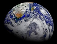
Satellite-based view of the Arctic. The images for this scene were captured on September 2, 2012, by the Visible Infrared… https://www.rawpixel.com/image/8717957/photo-image-clouds-space-planet Free Image from public domain license
Composite assembled from data acquired by the Suomi National Polar-orbiting Partnership satellite over nine days in April… https://www.rawpixel.com/image/440178/map-lights-night-from-nasa Free Image from public domain license
NASA-NOAA's Suomi NPP Satellite Gets Colorful Look at Hurricane Blanca. Original from NASA. Digitally enhanced by rawpixel. https://www.rawpixel.com/image/440152/free-photo-image-hurricane-nasa-storm Free Image from public domain license
Amazing image of the Earth. Original from NASA. Digitally enhanced by rawpixel. https://www.rawpixel.com/image/418640/free-photo-image-planet-nasa-marble Free Image from public domain license
Earth with grunge texture https://www.rawpixel.com/image/12633376/earth-with-grunge-texture View license
Amazing image of the United States of America at night. Original from NASA. Digitally enhanced by rawpixel. https://www.rawpixel.com/image/418600/united-states-america-night Free Image from public domain license
Environmental awareness sticker, editable design set https://www.rawpixel.com/image/14132564/environmental-awareness-sticker-editable-design-set View license Trending Design
Typhoon Phanfone affecting Japan, on October 5, 2014. Original from NASA. Digitally enhanced by rawpixel. https://www.rawpixel.com/image/440100/free-photo-image-typhoon-nasa-japan Free Image from public domain license
The Rio Tinto river in southwestern Spain. Original from NASA. Digitally enhanced by rawpixel. https://www.rawpixel.com/image/441261/free-photo-image-spain-rio-tinto-satellite-climate-change Free Image from public domain license
The magnificent natural landscape of Salzkammergut, Austria. Original from NASA . Digitally enhanced by rawpixel. https://www.rawpixel.com/image/441272/free-photo-image-topography-austria-earthquake Free Image from public domain license
Global Digital Elevation Model. Original from NASA. Digitally enhanced by rawpixel. https://www.rawpixel.com/image/441216/free-photo-image-atlas-thermal-imaging-globe Free Image from public domain license
Amazing image of the United States of America at night. Original from NASA. Digitally enhanced by rawpixel. https://www.rawpixel.com/image/418612/the-united-states-america-night Free Image from public domain license
Stormy photo with lightning effect https://www.rawpixel.com/image/12530698/stormy-photo-with-lightning-effect View license
Rising from fire and smoke, NASA's Juno planetary probe, enclosed in its payload fairing, launches atop a United Launch… https://www.rawpixel.com/image/440467/free-photo-image-nasa-goddard-space-flight-usa Free Image from public domain license
The Wilkins Ice Shelf on the western side of the Antarctic Peninsula. Original from NASA. Digitally enhanced by rawpixel. https://www.rawpixel.com/image/441236/free-photo-image-maps-snow-advanced-spaceborne-thermal-emission-and-reflection-radiometer-aster Free Image from public domain license
Image formed by the Advanced Spaceborne Thermal Emission and Reflection Radiometer (ASTER) and Global Digital Elevation… https://www.rawpixel.com/image/441205/free-photo-image-world-map-digital Free Image from public domain license
View of the heart of Shenandoah National Park on October 10, 2010, at the height of the fall “leaf-peeping”… https://www.rawpixel.com/image/440112/free-photo-image-climate-change-seasons-national-park Free Image from public domain license
The Indonesian islands of Komodo, Rintja, Padar, and Flores in the Komodo National Park. Original from NASA. Digitally… https://www.rawpixel.com/image/441183/free-photo-image-flores-indonesian-nationality-dragon Free Image from public domain license
A Heavy Oil Spill Into San Juan River Caused by a Burst Pipeline of the Texas - New Mexico Pipeline Company Required Massive… https://www.rawpixel.com/image/8803328/photo-image-person-airplane-ocean Free Image from public domain license
The Olympic National Park has to be one of America’s most diverse national park landscapes. Original from NASA.… https://www.rawpixel.com/image/440091/free-photo-image-satellite-nasa-olympic-national-park Free Image from public domain license
Climate crisis Instagram post template https://www.rawpixel.com/image/14909423/climate-crisis-instagram-post-template View license
Acadia National Park is one of the most visited parks in America. Original from NASA. Digitally enhanced by rawpixel. https://www.rawpixel.com/image/440092/free-photo-image-map-nasa-world Free Image from public domain license
Oriente Province, eastern end of Cuba, as seen from the National Aeronautics and Space Administration's Gemini-7 spacecraft.… https://www.rawpixel.com/image/441745/free-photo-image-santiago-maps-map-background Free Image from public domain license
The ice of a piedmont glacier spills from a steep valley onto a relatively flat plain. Malaspina Glacier, Alaska. Original… https://www.rawpixel.com/image/440088/free-photo-image-nasa-map-piedmont Free Image from public domain license
Planet poster template https://www.rawpixel.com/image/13138572/planet-poster-template View license Trending Design
An ER-2 high-altitude Earth science aircraft banks away during a flight over the southern Sierra Nevada. Original from NASA… https://www.rawpixel.com/image/440711/free-photo-image-nasa-military-satellite-snowy Free Image from public domain license
Typhoon Noru at peak intensity and displaying annular characteristics on July 31, 2017, located to the southwest of Iwo To. https://www.rawpixel.com/image/8718189/photo-image-cloud-public-domain-earth Free Image from public domain license
Tornado space outdoors nature. AI generated Image by rawpixel. https://www.rawpixel.com/image/13202532/tornado-space-outdoors-nature-generated-image-rawpixel View license
Tornado outdoors nature storm. AI generated Image by rawpixel. https://www.rawpixel.com/image/13202005/tornado-outdoors-nature-storm-generated-image-rawpixel View license
This image shows Hurricane Bob approaching New England on August 19 at 1226 UTC. This image was produced from data from NOAA… https://www.rawpixel.com/image/8718117/photo-image-public-domain-earth Free Image from public domain license
Hurricane Dennis threaded its way between Jamaica and Haiti on a direct course for Cuba on July 7, 2005. The storm now has… https://www.rawpixel.com/image/8717881/photo-image-public-domain-ocean-earth Free Image from public domain license
Hurricane Patricia shortly after peak intensity and approaching Western Mexico on October 23, 2015. https://www.rawpixel.com/image/8718177/photo-image-public-domain-earth-white Free Image from public domain license
Tornado outdoors nature space. AI generated Image by rawpixel. https://www.rawpixel.com/image/13202531/tornado-outdoors-nature-space-generated-image-rawpixel View license
Tornado space outdoors nature. AI generated Image by rawpixel. https://www.rawpixel.com/image/13202533/tornado-space-outdoors-nature-generated-image-rawpixel View license
Tornado space outdoors nature. AI generated Image by rawpixel. https://www.rawpixel.com/image/13202659/tornado-space-outdoors-nature-generated-image-rawpixel View license
Tornado space outdoors nature. AI generated Image by rawpixel. https://www.rawpixel.com/image/13202008/tornado-space-outdoors-nature-generated-image-rawpixel View license
Satellite image of Hurricane Katia (left) making landfall over the Mexican state of Veracruz, Hurricane Irma (center)… https://www.rawpixel.com/image/8718190/photo-image-public-domain-tropical-earth Free Image from public domain license
Teshekpuk Lake on Alaska's North Slope, within the National Petroleum Reserve. Original from NASA. Digitally enhanced by… https://www.rawpixel.com/image/441144/free-photo-image-science-alaska-world-map Free Image from public domain license
Greens and blues of the ocean color from NASA satellite data. Original from NASA. Digitally enhanced by rawpixel. https://www.rawpixel.com/image/440118/free-photo-image-maps-plankton-dance Free Image from public domain license
This image from NASA's Terra spacecraft shows the Kuk Early Agricultural Site in the western highlands of New Guinea.… https://www.rawpixel.com/image/441178/free-photo-image-swamp-nasa-climate-change Free Image from public domain license
NASA Satellite Captures Super Bowl Cities - Santa Clara, CA .Original from NASA. Digitally enhanced by rawpixel. https://www.rawpixel.com/image/440093/free-photo-image-california-map-maps-city-satellite Free Image from public domain license
Rare clear view of Alaska. Original from NASA. Digitally enhanced by rawpixel. https://www.rawpixel.com/image/440179/free-photo-image-coastline-forest-maps Free Image from public domain license
The Arctic Circle cuts through the western coast of Norway and the Saltfjellet-Svartisen National Park. Original from NASA.… https://www.rawpixel.com/image/441172/free-photo-image-nasa-climate-change-aerial Free Image from public domain license
Silk screen collage element, editable design set https://www.rawpixel.com/image/14328479/silk-screen-collage-element-editable-design-set View license Trending Design
Images of the Earth's land surface and surrounding coastal regions. Original from NASA. Digitally enhanced by rawpixel. https://www.rawpixel.com/image/440126/free-photo-image-map-coastal-nasa Free Image from public domain license
Longyearbyen, the largest island of the Svalbard archipelago, part of the Kingdom of Norway. Original from NASA. Digitally… https://www.rawpixel.com/image/439954/free-photo-image-nasa-norway-mountains-world-map Free Image from public domain license
Lake Naivasha, 90km north-west of Nairobi. Original from NASA. Digitally enhanced by rawpixel. https://www.rawpixel.com/image/441152/free-photo-image-kenya-nasa-lake-satellite-landscape Free Image from public domain license
Nadir view of the southern Cape District of South Africa. Original from NASA. Digitally enhanced by rawpixel. https://www.rawpixel.com/image/441620/free-photo-image-africa-south-cape-town Free Image from public domain license
NASA's Wallops Flight Facility is located on Wallops Island. Satellite imagery from NOAA's GOES-East satellite shows that… https://www.rawpixel.com/image/440110/free-photo-image-nasa-satellite-maps Free Image from public domain license
The Kondyor Massif is located in Eastern Siberia, Russia, north of the city of Khabarovsk. Original from NASA. Digitally… https://www.rawpixel.com/image/441148/free-photo-image-map-nasa-russia Free Image from public domain license
View of a cloudy earth shown from space. This particular image portrays the average of all of the satellite's cloud… https://www.rawpixel.com/image/440144/cloudy-earth Free Image from public domain license
Tropical Cyclone Bianca. Original from NASA. Digitally enhanced by rawpixel. https://www.rawpixel.com/image/440736/free-photo-image-public-domain-land-aerial-clouds Free Image from public domain license
Lying in the eastern Mediterranean Sea, the entire Island of Crete (35.0N, 25.0E) can be seen in great detail in this cloud… https://www.rawpixel.com/image/441790/free-photo-image-crete-greece-mediterranean Free Image from public domain license
View of portion of Queensland, Australia from Skylab space station. Original from NASA. Digitally enhanced by rawpixel https://www.rawpixel.com/image/441793/free-photo-image-australia-map-skylab Free Image from public domain license
This image from NASA's EarthKAM shows Lisbon, the capital of Portugal. Original from NASA. Digitally enhanced by rawpixel. https://www.rawpixel.com/image/441176/free-photo-image-map-satellite-maps-public-domain-portugal Free Image from public domain license
Skylab 3 Earth view of the Nile Delta, Egypt and Suez Canal. Original from NASA. Digitally enhanced by rawpixel. https://www.rawpixel.com/image/439888/free-photo-image-egypt-map-nasa-ocean Free Image from public domain license
View of the USSR, Siberia area from Skylab 4. Other areas seen are Ozero, Kanka, Ussiriysk, the Sea of Japan and Kavalerovo.… https://www.rawpixel.com/image/441773/free-photo-image-siberia-japan-maps Free Image from public domain license
The Isthmus of Corinth has played a very important role in the history of Greece. Original from NASA. Digitally enhanced by… https://www.rawpixel.com/image/441129/free-photo-image-nasa-greece-maps Free Image from public domain license
This image from NASA's EarthKAM captures almost all of Quinghai, the largest lake in China. Original from NASA. Digitally… https://www.rawpixel.com/image/441166/free-photo-image-china-map-space Free Image from public domain license
On August 22, 2014 the Moderate Resolution Imaging Spectroradiometer aboard NASA’s Terra satellite captured a true… https://www.rawpixel.com/image/440172/free-photo-image-nasa-iceland-satellite Free Image from public domain license
Hurricane Gonzalo's northern quadrant over Bermuda. Original from NASA. Digitally enhanced by rawpixel. https://www.rawpixel.com/image/440115/free-photo-image-hurricane-nasa-climate-change Free Image from public domain license
Earth observation by the crew of the International Space Station. Original from NASA. Digitally enhanced by rawpixel. https://www.rawpixel.com/image/440323/free-photo-image-new-zealand-maps-island Free Image from public domain license
Apollo 9 Mission image - S0-65 Multispectral Photography - New Mexico. Original from NASA. Digitally enhanced by rawpixel. https://www.rawpixel.com/image/440775/free-photo-image-lava-mexico-maps Free Image from public domain license
This image of the Galapagos Islands captures two large shield volcanoes on Isla Isabella. Original from NASA. Digitally… https://www.rawpixel.com/image/441165/free-photo-image-maps-ecuador-galapagos-islands Free Image from public domain license
Silk screen collage element, editable design set https://www.rawpixel.com/image/14328330/silk-screen-collage-element-editable-design-set View license Trending Design
Attu, the westernmost Aleutian island, is nearly 1760 km from the Alaskan mainland. Original from NASA. Digitally enhanced… https://www.rawpixel.com/image/441125/free-photo-image-nasa-map-space-earth Free Image from public domain license
Dendi Caldera, Ethiopia is featured in this image photographed by an Expedition 16 crew member on the International Space… https://www.rawpixel.com/image/440818/free-photo-image-ethiopia-nasa-satellite Free Image from public domain license
Lake Ilopango, a crater lake which fills a volcanic caldera in central El Salvador. Original from NASA. Digitally enhanced… https://www.rawpixel.com/image/440647/free-photo-image-salvador-satellite-lake Free Image from public domain license
Every southern spring and summer, after the Sun has risen into its 24-hour circuit around the skies of Antarctica, the Ross… https://www.rawpixel.com/image/440193/free-photo-image-maps-nasa-water Free Image from public domain license
Phytoplankton bloom in the Bay of Biscay. Original from NASA. Digitally enhanced by rawpixel. https://www.rawpixel.com/image/440161/free-photo-image-map-satellite-nasa Free Image from public domain license
Sheveluch Volcano in Kamchatka, Siberia. Original from NASA. Digitally enhanced by rawpixel. https://www.rawpixel.com/image/441226/free-photo-image-map-volcano-nasa Free Image from public domain license
View of the Arctic waters and the far northern lands surrounding it. Original from NASA. Digitally enhanced by rawpixel. https://www.rawpixel.com/image/440114/free-photo-image-nasa-map-arctic-sea Free Image from public domain license
Rostov-on-Don, a Russian City on the Don River, 32 kilometers from the Sea of Azov. Original from NASA. Digitally enhanced… https://www.rawpixel.com/image/440623/free-photo-image-nasa-map-world Free Image from public domain license
Pyroclastic Flow Remnants at Shiveluch Volcano. Original from NASA. Digitally enhanced by rawpixel. https://www.rawpixel.com/image/440238/free-photo-image-avalanche-volcano-february-2011 Free Image from public domain license
An image provided by the U.S. Naval Research Laboratory in Monterey, Calif., from a GOES-12 satellite shows Hurricane Alex… https://www.rawpixel.com/image/8729543/photo-image-public-domain-meteorology-nature Free Image from public domain license
Snow covered Alps of France, Italy, and Switzerland. Original from NASA. Digitally enhanced by rawpixel. https://www.rawpixel.com/image/441581/free-photo-image-nasa-switzerland-aerial Free Image from public domain license
This rare cloud-free view of southern Italy shows almost all of the famous `boot' configuration of the peninsula up to just… https://www.rawpixel.com/image/441789/free-photo-image-southern-italy-nasa-skylab Free Image from public domain license
Snow, which tends to be generally less bright that clouds, covers the Alps in the north of Italy. Original from NASA.… https://www.rawpixel.com/image/440140/free-photo-image-italy-map-maps Free Image from public domain license
Iran, Trucial Coast, Oman, Zagros Mountains, and Qishm Island (large island at lower left), as seen from the Gemini-12… https://www.rawpixel.com/image/441767/free-photo-image-nasa-map-iran Free Image from public domain license
View of Minneapolis-St.Paul, Minnesota area. Original from NASA. Digitally enhanced by rawpixel. https://www.rawpixel.com/image/441781/free-photo-image-nasa-minnesota-topography Free Image from public domain license
Arabian Peninsula and northeast Africa as seen from the orbiting Gemini-11. Original from NASA. Digitally enhanced by… https://www.rawpixel.com/image/441740/free-photo-image-africa-map-space-view Free Image from public domain license
Northern half of Mauritania's Atlantic Coast from Skylab. Original from NASA. Digitally enhanced by rawpixel. https://www.rawpixel.com/image/441592/free-photo-image-ocean-sand-aerial-view Free Image from public domain license
In this mostly cloud-free true-color scene, much of Scandinavia can be seen to be still covered by snow. Original from NASA.… https://www.rawpixel.com/image/440159/free-photo-image-scandinavia-norway-world-map Free Image from public domain license
Sediment Spews from Connecticut River. Original from NASA. Digitally enhanced by rawpixel. https://www.rawpixel.com/image/440189/free-photo-image-massachusetts-nasa-long-island Free Image from public domain license
Nearly cloud-free view of Great Britain and Ireland was acquired by the Moderate Resolution Imaging Spectroradiometer aboard… https://www.rawpixel.com/image/440141/great-britain-space-view Free Image from public domain license
Eruption of Cleveland Volcano, Aleutian Islands, Alaska. Original from NASA. Digitally enhanced by rawpixel. https://www.rawpixel.com/image/440821/free-photo-image-volcano-maps-nasa Free Image from public domain license
View of the southeastern tip of the Arabian Peninsula with the Gulf of Oman at upper right. Original from NASA . Digitally… https://www.rawpixel.com/image/441702/free-photo-image-nasa-satellite-arabian Free Image from public domain license
The world largest bauxite mine found near Weipa, Queensland, Australia. Original from NASA. Digitally enhanced by rawpixel. https://www.rawpixel.com/image/439912/free-photo-image-water-conservation-australia-mountain Free Image from public domain license
The world's largest bauxite mine found near Weipa, Queensland, Australia. Original from NASA. Digitally enhanced by rawpixel. https://www.rawpixel.com/image/440663/free-photo-image-1955-1960-aluminium Free Image from public domain license
Beautiful new mosaic of Chesapeake Bay. Original from NASA. Digitally enhanced by rawpixel. https://www.rawpixel.com/image/440207/free-photo-image-maps-aerial-satellite-view Free Image from public domain license
Satellite Shows an "Arctic Blanket" Over the U.S. Original from NASA. Digitally enhanced by rawpixel. https://www.rawpixel.com/image/440086/free-photo-image-earth-planet-space Free Image from public domain license
NASA image acquired August 17, 2010, the Northwest Passage almost free of ice. Original from NASA. Digitally enhanced by… https://www.rawpixel.com/image/440249/free-photo-image-passage-global-warming-nasa Free Image from public domain license
The Lena River, some 2,800 miles long, is one of the largest rivers in the world. Original from NASA. Digitally enhanced by… https://www.rawpixel.com/image/440230/free-photo-image-nasa-russia-earth Free Image from public domain license