![Nearly cloud-free view of Great Britain and Ireland was acquired by the Moderate Resolution Imaging Spectroradiometer aboard…]() Nearly cloud-free view of Great Britain and Ireland was acquired by the Moderate Resolution Imaging Spectroradiometer aboard…
Nearly cloud-free view of Great Britain and Ireland was acquired by the Moderate Resolution Imaging Spectroradiometer aboard…![This observation from NASA's Mars Reconnaissance Orbiter covers an outcrop of possible cyclic bedding within a crater in…]() This observation from NASA's Mars Reconnaissance Orbiter covers an outcrop of possible cyclic bedding within a crater in…
This observation from NASA's Mars Reconnaissance Orbiter covers an outcrop of possible cyclic bedding within a crater in…![Image taken by a new Earth-observing instrument installed on the international space station. Original from NASA. Digitally…]() Image taken by a new Earth-observing instrument installed on the international space station. Original from NASA. Digitally…
Image taken by a new Earth-observing instrument installed on the international space station. Original from NASA. Digitally…![Little Bahama Bank, the most northerly of the island groups that comprise the Bahamas. Original from NASA. Digitally…]() Little Bahama Bank, the most northerly of the island groups that comprise the Bahamas. Original from NASA. Digitally…
Little Bahama Bank, the most northerly of the island groups that comprise the Bahamas. Original from NASA. Digitally…![Skylab 3 Earth view of the Grand Canyon, Lake Mead and Kaibab. Original from NASA. Digitally enhanced by rawpixel.]() Skylab 3 Earth view of the Grand Canyon, Lake Mead and Kaibab. Original from NASA. Digitally enhanced by rawpixel.
Skylab 3 Earth view of the Grand Canyon, Lake Mead and Kaibab. Original from NASA. Digitally enhanced by rawpixel.![Parts of the vast Ganges delta, in fact the world's largest, lie in both Bangladesh and the State of West Bengal, India.…]() Parts of the vast Ganges delta, in fact the world's largest, lie in both Bangladesh and the State of West Bengal, India.…
Parts of the vast Ganges delta, in fact the world's largest, lie in both Bangladesh and the State of West Bengal, India.…![The southernmost reaches of Burma (Myanmar), the Mergui Archipelago along the border with Thailand. Original from NASA .…]() The southernmost reaches of Burma (Myanmar), the Mergui Archipelago along the border with Thailand. Original from NASA .…
The southernmost reaches of Burma (Myanmar), the Mergui Archipelago along the border with Thailand. Original from NASA .…![Northern half of Mauritania's Atlantic Coast from Skylab. Original from NASA. Digitally enhanced by rawpixel.]() Northern half of Mauritania's Atlantic Coast from Skylab. Original from NASA. Digitally enhanced by rawpixel.
Northern half of Mauritania's Atlantic Coast from Skylab. Original from NASA. Digitally enhanced by rawpixel.![View of the southeastern tip of the Arabian Peninsula with the Gulf of Oman at upper right. Original from NASA . Digitally…]() View of the southeastern tip of the Arabian Peninsula with the Gulf of Oman at upper right. Original from NASA . Digitally…
View of the southeastern tip of the Arabian Peninsula with the Gulf of Oman at upper right. Original from NASA . Digitally…![Greens and blues of the ocean color from NASA satellite data. Original from NASA. Digitally enhanced by rawpixel.]() Greens and blues of the ocean color from NASA satellite data. Original from NASA. Digitally enhanced by rawpixel.
Greens and blues of the ocean color from NASA satellite data. Original from NASA. Digitally enhanced by rawpixel.![Nadir view of the southern Cape District of South Africa. Original from NASA. Digitally enhanced by rawpixel.]() Nadir view of the southern Cape District of South Africa. Original from NASA. Digitally enhanced by rawpixel.
Nadir view of the southern Cape District of South Africa. Original from NASA. Digitally enhanced by rawpixel.![Rare clear view of Alaska. Original from NASA. Digitally enhanced by rawpixel.]() Rare clear view of Alaska. Original from NASA. Digitally enhanced by rawpixel.
Rare clear view of Alaska. Original from NASA. Digitally enhanced by rawpixel.![Images of the Earth's land surface and surrounding coastal regions. Original from NASA. Digitally enhanced by rawpixel.]() Images of the Earth's land surface and surrounding coastal regions. Original from NASA. Digitally enhanced by rawpixel.
Images of the Earth's land surface and surrounding coastal regions. Original from NASA. Digitally enhanced by rawpixel.![NASA's Wallops Flight Facility is located on Wallops Island. Satellite imagery from NOAA's GOES-East satellite shows that…]() NASA's Wallops Flight Facility is located on Wallops Island. Satellite imagery from NOAA's GOES-East satellite shows that…
NASA's Wallops Flight Facility is located on Wallops Island. Satellite imagery from NOAA's GOES-East satellite shows that…![Rio Gurupi in the Brazilian state of Maranhao and its delta.Original from NASA. Digitally enhanced by rawpixel.]() Rio Gurupi in the Brazilian state of Maranhao and its delta.Original from NASA. Digitally enhanced by rawpixel.
Rio Gurupi in the Brazilian state of Maranhao and its delta.Original from NASA. Digitally enhanced by rawpixel.![Sand dunes trapped in an impact crater in Noachis Terra, Mars. Original from NASA. Digitally enhanced by rawpixel.]() Sand dunes trapped in an impact crater in Noachis Terra, Mars. Original from NASA. Digitally enhanced by rawpixel.
Sand dunes trapped in an impact crater in Noachis Terra, Mars. Original from NASA. Digitally enhanced by rawpixel.![The Soyuz TMA-16 launches from the Baikonur Cosmodrome in Kazakhstan on Sept. 30, 2009. Original from NASA. Digitally…]() The Soyuz TMA-16 launches from the Baikonur Cosmodrome in Kazakhstan on Sept. 30, 2009. Original from NASA. Digitally…
The Soyuz TMA-16 launches from the Baikonur Cosmodrome in Kazakhstan on Sept. 30, 2009. Original from NASA. Digitally…![Parts of he Kimberley region of Western Australia. Original from NASA. Digitally enhanced by rawpixel.]() Parts of he Kimberley region of Western Australia. Original from NASA. Digitally enhanced by rawpixel.
Parts of he Kimberley region of Western Australia. Original from NASA. Digitally enhanced by rawpixel.![Apollo 9 Mission image - S0-65 Multispectral Photography - New Mexico. Original from NASA. Digitally enhanced by rawpixel.]() Apollo 9 Mission image - S0-65 Multispectral Photography - New Mexico. Original from NASA. Digitally enhanced by rawpixel.
Apollo 9 Mission image - S0-65 Multispectral Photography - New Mexico. Original from NASA. Digitally enhanced by rawpixel.![NASA Shuttle Radar Topography Mission imaged Sendai, the capital city of Japan Miyagi Prefecture a magnitude 8.9 earthquake…]() NASA Shuttle Radar Topography Mission imaged Sendai, the capital city of Japan Miyagi Prefecture a magnitude 8.9 earthquake…
NASA Shuttle Radar Topography Mission imaged Sendai, the capital city of Japan Miyagi Prefecture a magnitude 8.9 earthquake…![Snow, which tends to be generally less bright that clouds, covers the Alps in the north of Italy. Original from NASA.…]() Snow, which tends to be generally less bright that clouds, covers the Alps in the north of Italy. Original from NASA.…
Snow, which tends to be generally less bright that clouds, covers the Alps in the north of Italy. Original from NASA.…![This image from NASA's EarthKAM shows Lisbon, the capital of Portugal. Original from NASA. Digitally enhanced by rawpixel.]() This image from NASA's EarthKAM shows Lisbon, the capital of Portugal. Original from NASA. Digitally enhanced by rawpixel.
This image from NASA's EarthKAM shows Lisbon, the capital of Portugal. Original from NASA. Digitally enhanced by rawpixel.![Skylab 3 Earth view of the Nile Delta, Egypt and Suez Canal. Original from NASA. Digitally enhanced by rawpixel.]() Skylab 3 Earth view of the Nile Delta, Egypt and Suez Canal. Original from NASA. Digitally enhanced by rawpixel.
Skylab 3 Earth view of the Nile Delta, Egypt and Suez Canal. Original from NASA. Digitally enhanced by rawpixel.![This image from NASA's EarthKAM captures almost all of Quinghai, the largest lake in China. Original from NASA. Digitally…]() This image from NASA's EarthKAM captures almost all of Quinghai, the largest lake in China. Original from NASA. Digitally…
This image from NASA's EarthKAM captures almost all of Quinghai, the largest lake in China. Original from NASA. Digitally…![Sand dunes and ripples in Proctor Crater, Mars. Original from NASA. Digitally enhanced by rawpixel.]() Sand dunes and ripples in Proctor Crater, Mars. Original from NASA. Digitally enhanced by rawpixel.
Sand dunes and ripples in Proctor Crater, Mars. Original from NASA. Digitally enhanced by rawpixel.![Dendi Caldera, Ethiopia is featured in this image photographed by an Expedition 16 crew member on the International Space…]() Dendi Caldera, Ethiopia is featured in this image photographed by an Expedition 16 crew member on the International Space…
Dendi Caldera, Ethiopia is featured in this image photographed by an Expedition 16 crew member on the International Space…![View of the heart of Shenandoah National Park on October 10, 2010, at the height of the fall “leaf-peeping”…]() View of the heart of Shenandoah National Park on October 10, 2010, at the height of the fall “leaf-peeping”…
View of the heart of Shenandoah National Park on October 10, 2010, at the height of the fall “leaf-peeping”…![Savannah River Site, South Carolina. Original from NASA. Digitally enhanced by rawpixel.]() Savannah River Site, South Carolina. Original from NASA. Digitally enhanced by rawpixel.
Savannah River Site, South Carolina. Original from NASA. Digitally enhanced by rawpixel.![View of the Arctic waters and the far northern lands surrounding it. Original from NASA. Digitally enhanced by rawpixel.]() View of the Arctic waters and the far northern lands surrounding it. Original from NASA. Digitally enhanced by rawpixel.
View of the Arctic waters and the far northern lands surrounding it. Original from NASA. Digitally enhanced by rawpixel.![This image of the Galapagos Islands captures two large shield volcanoes on Isla Isabella. Original from NASA. Digitally…]() This image of the Galapagos Islands captures two large shield volcanoes on Isla Isabella. Original from NASA. Digitally…
This image of the Galapagos Islands captures two large shield volcanoes on Isla Isabella. Original from NASA. Digitally…![The STS-93 astronauts aboard the Space Shuttle Columbia took this picture over the Indian Ocean on 23-27 July 1999. Original…]() The STS-93 astronauts aboard the Space Shuttle Columbia took this picture over the Indian Ocean on 23-27 July 1999. Original…
The STS-93 astronauts aboard the Space Shuttle Columbia took this picture over the Indian Ocean on 23-27 July 1999. Original…![Central area of Ethiopia, south of Addis Ababa, showing Lakes Zwai, Langana, and Shala. Original from NASA. Digitally…]() Central area of Ethiopia, south of Addis Ababa, showing Lakes Zwai, Langana, and Shala. Original from NASA. Digitally…
Central area of Ethiopia, south of Addis Ababa, showing Lakes Zwai, Langana, and Shala. Original from NASA. Digitally…![Earth observation by the crew of the International Space Station. Original from NASA. Digitally enhanced by rawpixel.]() Earth observation by the crew of the International Space Station. Original from NASA. Digitally enhanced by rawpixel.
Earth observation by the crew of the International Space Station. Original from NASA. Digitally enhanced by rawpixel.![A plume at Shiveluch Volcano, Kamchatka Peninsula, Russia. Original from NASA. Digitally enhanced by rawpixel.]() A plume at Shiveluch Volcano, Kamchatka Peninsula, Russia. Original from NASA. Digitally enhanced by rawpixel.
A plume at Shiveluch Volcano, Kamchatka Peninsula, Russia. Original from NASA. Digitally enhanced by rawpixel.![Phytoplankton bloom in the Bay of Biscay. Original from NASA. Digitally enhanced by rawpixel.]() Phytoplankton bloom in the Bay of Biscay. Original from NASA. Digitally enhanced by rawpixel.
Phytoplankton bloom in the Bay of Biscay. Original from NASA. Digitally enhanced by rawpixel.![NASA Satellite Captures Super Bowl Cities - Santa Clara, CA .Original from NASA. Digitally enhanced by rawpixel.]() NASA Satellite Captures Super Bowl Cities - Santa Clara, CA .Original from NASA. Digitally enhanced by rawpixel.
NASA Satellite Captures Super Bowl Cities - Santa Clara, CA .Original from NASA. Digitally enhanced by rawpixel.![Every southern spring and summer, after the Sun has risen into its 24-hour circuit around the skies of Antarctica, the Ross…]() Every southern spring and summer, after the Sun has risen into its 24-hour circuit around the skies of Antarctica, the Ross…
Every southern spring and summer, after the Sun has risen into its 24-hour circuit around the skies of Antarctica, the Ross…![The eastern end of the Gulf of Fonseca, in Honduras. Original from NASA. Digitally enhanced by rawpixel.]() The eastern end of the Gulf of Fonseca, in Honduras. Original from NASA. Digitally enhanced by rawpixel.
The eastern end of the Gulf of Fonseca, in Honduras. Original from NASA. Digitally enhanced by rawpixel.![F-18 Systems Research Aircraft (SRA) in flight, October 3rd, 1997. Original from NASA. Digitally enhanced by rawpixel.]() F-18 Systems Research Aircraft (SRA) in flight, October 3rd, 1997. Original from NASA. Digitally enhanced by rawpixel.
F-18 Systems Research Aircraft (SRA) in flight, October 3rd, 1997. Original from NASA. Digitally enhanced by rawpixel.![NASA scientists are flying over Alaska and Canada, measuring the elevation of rivers and lakes. Original from NASA.…]() NASA scientists are flying over Alaska and Canada, measuring the elevation of rivers and lakes. Original from NASA.…
NASA scientists are flying over Alaska and Canada, measuring the elevation of rivers and lakes. Original from NASA.…![GOES 11 satellite image showing earth on March 25, 2010. Original from NASA. Digitally enhanced by rawpixel.]() GOES 11 satellite image showing earth on March 25, 2010. Original from NASA. Digitally enhanced by rawpixel.
GOES 11 satellite image showing earth on March 25, 2010. Original from NASA. Digitally enhanced by rawpixel.![Parts of Galveston and Harris Counties and Galveston Bay and several communities in the Clear Lake area. Original from NASA.…]() Parts of Galveston and Harris Counties and Galveston Bay and several communities in the Clear Lake area. Original from NASA.…
Parts of Galveston and Harris Counties and Galveston Bay and several communities in the Clear Lake area. Original from NASA.…![Snow covered Alps of France, Italy, and Switzerland. Original from NASA. Digitally enhanced by rawpixel.]() Snow covered Alps of France, Italy, and Switzerland. Original from NASA. Digitally enhanced by rawpixel.
Snow covered Alps of France, Italy, and Switzerland. Original from NASA. Digitally enhanced by rawpixel.![Eruption of Cleveland Volcano, Aleutian Islands, Alaska. Original from NASA. Digitally enhanced by rawpixel.]() Eruption of Cleveland Volcano, Aleutian Islands, Alaska. Original from NASA. Digitally enhanced by rawpixel.
Eruption of Cleveland Volcano, Aleutian Islands, Alaska. Original from NASA. Digitally enhanced by rawpixel.![Moffett Federal Air Field, NASA Ames Research Center and Silicon Valley. Original from NASA. Digitally enhanced by rawpixel.]() Moffett Federal Air Field, NASA Ames Research Center and Silicon Valley. Original from NASA. Digitally enhanced by rawpixel.
Moffett Federal Air Field, NASA Ames Research Center and Silicon Valley. Original from NASA. Digitally enhanced by rawpixel.![Sediment Spews from Connecticut River. Original from NASA. Digitally enhanced by rawpixel.]() Sediment Spews from Connecticut River. Original from NASA. Digitally enhanced by rawpixel.
Sediment Spews from Connecticut River. Original from NASA. Digitally enhanced by rawpixel.![In this mostly cloud-free true-color scene, much of Scandinavia can be seen to be still covered by snow. Original from NASA.…]() In this mostly cloud-free true-color scene, much of Scandinavia can be seen to be still covered by snow. Original from NASA.…
In this mostly cloud-free true-color scene, much of Scandinavia can be seen to be still covered by snow. Original from NASA.…![This is an 800mm oblique view which covers an area including Moffett Federal Air Field, NASA's Ames Research Center…]() This is an 800mm oblique view which covers an area including Moffett Federal Air Field, NASA's Ames Research Center…
This is an 800mm oblique view which covers an area including Moffett Federal Air Field, NASA's Ames Research Center…![Global Digital Elevation Model. Original from NASA. Digitally enhanced by rawpixel.]() Global Digital Elevation Model. Original from NASA. Digitally enhanced by rawpixel.
Global Digital Elevation Model. Original from NASA. Digitally enhanced by rawpixel.![Sakhalin Island, located just north of Japan and east of the Khabarovski and Primorski Krai of the Russian Far East.…]() Sakhalin Island, located just north of Japan and east of the Khabarovski and Primorski Krai of the Russian Far East.…
Sakhalin Island, located just north of Japan and east of the Khabarovski and Primorski Krai of the Russian Far East.…![Snow-capped peaks and ridges of the eastern Himalaya Mountains. Original from NASA. Digitally enhanced by rawpixel.]() Snow-capped peaks and ridges of the eastern Himalaya Mountains. Original from NASA. Digitally enhanced by rawpixel.
Snow-capped peaks and ridges of the eastern Himalaya Mountains. Original from NASA. Digitally enhanced by rawpixel.![The Zambezi, the fourth largest river in Africa, and the largest east-flowing waterway. Original from NASA. Digitally…]() The Zambezi, the fourth largest river in Africa, and the largest east-flowing waterway. Original from NASA. Digitally…
The Zambezi, the fourth largest river in Africa, and the largest east-flowing waterway. Original from NASA. Digitally…![Earth observations taken from Space Shuttle Columbia during STS-93 mission. Original from NASA. Digitally enhanced by…]() Earth observations taken from Space Shuttle Columbia during STS-93 mission. Original from NASA. Digitally enhanced by…
Earth observations taken from Space Shuttle Columbia during STS-93 mission. Original from NASA. Digitally enhanced by…![New image of the Earth at night is a composite assembled from data acquired by the Suomi National Polar-orbiting Partnership…]() New image of the Earth at night is a composite assembled from data acquired by the Suomi National Polar-orbiting Partnership…
New image of the Earth at night is a composite assembled from data acquired by the Suomi National Polar-orbiting Partnership…![Images of the Earth's land surface and surrounding coastal regions. Original from NASA. Digitally enhanced by rawpixel.]() Images of the Earth's land surface and surrounding coastal regions. Original from NASA. Digitally enhanced by rawpixel.
Images of the Earth's land surface and surrounding coastal regions. Original from NASA. Digitally enhanced by rawpixel.![GOES 12 satellite image showing earth on March 25, 2010. Original from NASA . Digitally enhanced by rawpixel.]() GOES 12 satellite image showing earth on March 25, 2010. Original from NASA . Digitally enhanced by rawpixel.
GOES 12 satellite image showing earth on March 25, 2010. Original from NASA . Digitally enhanced by rawpixel.![Northern Namibia, known for its widespread bare and sinuous parallel dunes, most of them red. Original from NASA. Digitally…]() Northern Namibia, known for its widespread bare and sinuous parallel dunes, most of them red. Original from NASA. Digitally…
Northern Namibia, known for its widespread bare and sinuous parallel dunes, most of them red. Original from NASA. Digitally…![Beautiful new mosaic of Chesapeake Bay. Original from NASA. Digitally enhanced by rawpixel.]() Beautiful new mosaic of Chesapeake Bay. Original from NASA. Digitally enhanced by rawpixel.
Beautiful new mosaic of Chesapeake Bay. Original from NASA. Digitally enhanced by rawpixel.![Lake Torrens and the Australian Outback. Original from NASA. Digitally enhanced by rawpixel.]() Lake Torrens and the Australian Outback. Original from NASA. Digitally enhanced by rawpixel.
Lake Torrens and the Australian Outback. Original from NASA. Digitally enhanced by rawpixel.![The Rub' al Khali, one of the largest sand deserts in the world, encompassing most of the southern third of the Arabian…]() The Rub' al Khali, one of the largest sand deserts in the world, encompassing most of the southern third of the Arabian…
The Rub' al Khali, one of the largest sand deserts in the world, encompassing most of the southern third of the Arabian…![View of Florence, Italy area from the Skylab. Original from NASA. Digitally enhanced by rawpixel.]() View of Florence, Italy area from the Skylab. Original from NASA. Digitally enhanced by rawpixel.
View of Florence, Italy area from the Skylab. Original from NASA. Digitally enhanced by rawpixel.![Oil from the Deepwater Horizon spill laps around the mouth of the Mississippi River Delta, May 24, 2010. Original from NASA.…]() Oil from the Deepwater Horizon spill laps around the mouth of the Mississippi River Delta, May 24, 2010. Original from NASA.…
Oil from the Deepwater Horizon spill laps around the mouth of the Mississippi River Delta, May 24, 2010. Original from NASA.…![Calcite Quarry, Michigan. Original from NASA. Digitally enhanced by rawpixel.]() Calcite Quarry, Michigan. Original from NASA. Digitally enhanced by rawpixel.
Calcite Quarry, Michigan. Original from NASA. Digitally enhanced by rawpixel.![Acadia National Park is one of the most visited parks in America. Original from NASA. Digitally enhanced by rawpixel.]() Acadia National Park is one of the most visited parks in America. Original from NASA. Digitally enhanced by rawpixel.
Acadia National Park is one of the most visited parks in America. Original from NASA. Digitally enhanced by rawpixel.![MODIS on the Aqua satellite captured this stunning view of Japans four largest islands on February 20, 2004. Original from…]() MODIS on the Aqua satellite captured this stunning view of Japans four largest islands on February 20, 2004. Original from…
MODIS on the Aqua satellite captured this stunning view of Japans four largest islands on February 20, 2004. Original from…![View of the Himalaya Mountain Range in the India-Nepal-Tibet border area. Original from NASA. Digitally enhanced by rawpixel.]() View of the Himalaya Mountain Range in the India-Nepal-Tibet border area. Original from NASA. Digitally enhanced by rawpixel.
View of the Himalaya Mountain Range in the India-Nepal-Tibet border area. Original from NASA. Digitally enhanced by rawpixel.![Island of Hawaii, State of Hawaii seen from Skylab. Original from NASA. Digitally enhanced by rawpixel.]() Island of Hawaii, State of Hawaii seen from Skylab. Original from NASA. Digitally enhanced by rawpixel.
Island of Hawaii, State of Hawaii seen from Skylab. Original from NASA. Digitally enhanced by rawpixel.![Full Mir over New Zealand, from the space shuttle Atlantis, Russia's Mir Space Station. Original from NASA. Digitally…]() Full Mir over New Zealand, from the space shuttle Atlantis, Russia's Mir Space Station. Original from NASA. Digitally…
Full Mir over New Zealand, from the space shuttle Atlantis, Russia's Mir Space Station. Original from NASA. Digitally…![Los Angeles and vicinity seen from space on May 4, 2001. Original from NASA. Digitally enhanced by rawpixel.]() Los Angeles and vicinity seen from space on May 4, 2001. Original from NASA. Digitally enhanced by rawpixel.
Los Angeles and vicinity seen from space on May 4, 2001. Original from NASA. Digitally enhanced by rawpixel.![The central coastal area of Peru as seen from the Gemini-9A spacecraft. Original from NASA. Digitally enhanced by rawpixel]() The central coastal area of Peru as seen from the Gemini-9A spacecraft. Original from NASA. Digitally enhanced by rawpixel
The central coastal area of Peru as seen from the Gemini-9A spacecraft. Original from NASA. Digitally enhanced by rawpixel![Plankton blooms in the Falkland Current east of the Argentinian coast. Original from NASA. Digitally enhanced by rawpixel.]() Plankton blooms in the Falkland Current east of the Argentinian coast. Original from NASA. Digitally enhanced by rawpixel.
Plankton blooms in the Falkland Current east of the Argentinian coast. Original from NASA. Digitally enhanced by rawpixel.![NASA GOES 12 satellite image showing earth on March 30, 2010. Original from NASA. Digitally enhanced by rawpixel.]() NASA GOES 12 satellite image showing earth on March 30, 2010. Original from NASA. Digitally enhanced by rawpixel.
NASA GOES 12 satellite image showing earth on March 30, 2010. Original from NASA. Digitally enhanced by rawpixel.![The ice of a piedmont glacier spills from a steep valley onto a relatively flat plain. Malaspina Glacier, Alaska. Original…]() The ice of a piedmont glacier spills from a steep valley onto a relatively flat plain. Malaspina Glacier, Alaska. Original…
The ice of a piedmont glacier spills from a steep valley onto a relatively flat plain. Malaspina Glacier, Alaska. Original…![Earth observations taken during STS-77 mission. Original from NASA. Digitally enhanced by rawpixel.]() Earth observations taken during STS-77 mission. Original from NASA. Digitally enhanced by rawpixel.
Earth observations taken during STS-77 mission. Original from NASA. Digitally enhanced by rawpixel.![Remote sensing of ocean color in the Yellow Sea. Original from NASA. Digitally enhanced by rawpixel.]() Remote sensing of ocean color in the Yellow Sea. Original from NASA. Digitally enhanced by rawpixel.
Remote sensing of ocean color in the Yellow Sea. Original from NASA. Digitally enhanced by rawpixel.![Cosiguina Volcano, Nicaragua. Original from NASA. Digitally enhanced by rawpixel.]() Cosiguina Volcano, Nicaragua. Original from NASA. Digitally enhanced by rawpixel.
Cosiguina Volcano, Nicaragua. Original from NASA. Digitally enhanced by rawpixel.![Sediment Transforms Lake Michigan, Original from NASA. Digitally enhanced by rawpixel.]() Sediment Transforms Lake Michigan, Original from NASA. Digitally enhanced by rawpixel.
Sediment Transforms Lake Michigan, Original from NASA. Digitally enhanced by rawpixel.![View of Melbourne, Australia as seen from the Skylab space station. Original from NASA. Digitally enhanced by rawpixel.]() View of Melbourne, Australia as seen from the Skylab space station. Original from NASA. Digitally enhanced by rawpixel.
View of Melbourne, Australia as seen from the Skylab space station. Original from NASA. Digitally enhanced by rawpixel.![This spaceborne radar image shows the area just north of the city of Cairo, Egypt, where the Nile River splits into two main…]() This spaceborne radar image shows the area just north of the city of Cairo, Egypt, where the Nile River splits into two main…
This spaceborne radar image shows the area just north of the city of Cairo, Egypt, where the Nile River splits into two main…![San Francisco and Bay Area, CA, USA. Original from NASA. Digitally enhanced by rawpixel.]() San Francisco and Bay Area, CA, USA. Original from NASA. Digitally enhanced by rawpixel.
San Francisco and Bay Area, CA, USA. Original from NASA. Digitally enhanced by rawpixel.![Testing autonomous software for AARD program using a NASA F/A-18 #845 following a chartered Sabreliner, June 27th, 2006.…]() Testing autonomous software for AARD program using a NASA F/A-18 #845 following a chartered Sabreliner, June 27th, 2006.…
Testing autonomous software for AARD program using a NASA F/A-18 #845 following a chartered Sabreliner, June 27th, 2006.…![Earth observations of Houston taken by STS-115 crew member. Original from NASA. Digitally enhanced by rawpixel.]() Earth observations of Houston taken by STS-115 crew member. Original from NASA. Digitally enhanced by rawpixel.
Earth observations of Houston taken by STS-115 crew member. Original from NASA. Digitally enhanced by rawpixel.![The Olympic National Park has to be one of America’s most diverse national park landscapes. Original from NASA.…]() The Olympic National Park has to be one of America’s most diverse national park landscapes. Original from NASA.…
The Olympic National Park has to be one of America’s most diverse national park landscapes. Original from NASA.…![An F/A-18 Super Hornet demonstrates its flying capabilities. Original from NASA. Digitally enhanced by rawpixel.]() An F/A-18 Super Hornet demonstrates its flying capabilities. Original from NASA. Digitally enhanced by rawpixel.
An F/A-18 Super Hornet demonstrates its flying capabilities. Original from NASA. Digitally enhanced by rawpixel.![Earth observations of Argentina and Chile was among several of South America. Original from NASA. Digitally enhanced by…]() Earth observations of Argentina and Chile was among several of South America. Original from NASA. Digitally enhanced by…
Earth observations of Argentina and Chile was among several of South America. Original from NASA. Digitally enhanced by…![RAIF Hangar Bays 1 and 2. Original from NASA. Digitally enhanced by rawpixel.]() RAIF Hangar Bays 1 and 2. Original from NASA. Digitally enhanced by rawpixel.
RAIF Hangar Bays 1 and 2. Original from NASA. Digitally enhanced by rawpixel.![The rugged landscape of the Canary Islands. Original from NASA. Digitally enhanced by rawpixel.]() The rugged landscape of the Canary Islands. Original from NASA. Digitally enhanced by rawpixel.
The rugged landscape of the Canary Islands. Original from NASA. Digitally enhanced by rawpixel.![Baja California, Colorado river and Sonora Desert. Original from NASA. Digitally enhanced by rawpixel.]() Baja California, Colorado river and Sonora Desert. Original from NASA. Digitally enhanced by rawpixel.
Baja California, Colorado river and Sonora Desert. Original from NASA. Digitally enhanced by rawpixel.![U.S. Navy Chief Damage Controlman Gregory Hightower demonstrates how to perform damage control procedures while inside a…]() U.S. Navy Chief Damage Controlman Gregory Hightower demonstrates how to perform damage control procedures while inside a…
U.S. Navy Chief Damage Controlman Gregory Hightower demonstrates how to perform damage control procedures while inside a…![As the sun sets on July 8, 2010, workers prepare to pour new epoxy grout for the hydrostatic bearing assembly of the giant…]() As the sun sets on July 8, 2010, workers prepare to pour new epoxy grout for the hydrostatic bearing assembly of the giant…
As the sun sets on July 8, 2010, workers prepare to pour new epoxy grout for the hydrostatic bearing assembly of the giant…![NASA astronaut Rick Mastracchio during EVA 2. Original from NASA. Digitally enhanced by rawpixel.]() NASA astronaut Rick Mastracchio during EVA 2. Original from NASA. Digitally enhanced by rawpixel.
NASA astronaut Rick Mastracchio during EVA 2. Original from NASA. Digitally enhanced by rawpixel.![International Space Station solar array wings. Original from NASA. Digitally enhanced by rawpixel.]() International Space Station solar array wings. Original from NASA. Digitally enhanced by rawpixel.
International Space Station solar array wings. Original from NASA. Digitally enhanced by rawpixel.![Cancun, a resort city on the east side of Mexico's Yucatan Peninsula. Original from NASA. Digitally enhanced by rawpixel.]() Cancun, a resort city on the east side of Mexico's Yucatan Peninsula. Original from NASA. Digitally enhanced by rawpixel.
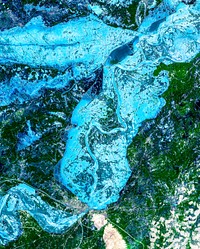
Cancun, a resort city on the east side of Mexico's Yucatan Peninsula. Original from NASA. Digitally enhanced by rawpixel.![Massive congregations of greenish phytoplankton swirl in the dark water around Gotland, a Swedish island in the Baltic Sea.…]() Massive congregations of greenish phytoplankton swirl in the dark water around Gotland, a Swedish island in the Baltic Sea.…
Massive congregations of greenish phytoplankton swirl in the dark water around Gotland, a Swedish island in the Baltic Sea.…![NASA's F/A-18B #845 was captured by the photographer as it returned from its final flight in the Autonomous Airborne…]() NASA's F/A-18B #845 was captured by the photographer as it returned from its final flight in the Autonomous Airborne…
NASA's F/A-18B #845 was captured by the photographer as it returned from its final flight in the Autonomous Airborne…![Two F/A-18 jets fly over the Shuttle Landing Facility at NASA's Kennedy Space Center in Florida. Original from NASA.…]() Two F/A-18 jets fly over the Shuttle Landing Facility at NASA's Kennedy Space Center in Florida. Original from NASA.…
Two F/A-18 jets fly over the Shuttle Landing Facility at NASA's Kennedy Space Center in Florida. Original from NASA.…![The U.S. Navy's F/A-18 Blue Angels begin taxiing toward the runway at the Shuttle Landing Facility at NASA's Kennedy Space…]() The U.S. Navy's F/A-18 Blue Angels begin taxiing toward the runway at the Shuttle Landing Facility at NASA's Kennedy Space…
The U.S. Navy's F/A-18 Blue Angels begin taxiing toward the runway at the Shuttle Landing Facility at NASA's Kennedy Space…