![Hand drawn globe illustration]() Hand drawn globe illustration
Hand drawn globe illustration![Hand drawn globe illustration]() Hand drawn globe illustration
Hand drawn globe illustration![Globe collage element, hand drawn illustration psd]() Globe collage element, hand drawn illustration psd
Globe collage element, hand drawn illustration psd![Globe collage element, vintage illustration psd]() Globe collage element, vintage illustration psd
Globe collage element, vintage illustration psd![Png globe sticker, vintage illustration, transparent background]() Png globe sticker, vintage illustration, transparent background
Png globe sticker, vintage illustration, transparent background![Hand drawn globe vintage illustration on torn paper]() Hand drawn globe vintage illustration on torn paper
Hand drawn globe vintage illustration on torn paper![Hand drawn globe vintage illustration on torn paper]() Hand drawn globe vintage illustration on torn paper
Hand drawn globe vintage illustration on torn paper![Png globe sticker, vintage illustration, transparent background]() Png globe sticker, vintage illustration, transparent background
Png globe sticker, vintage illustration, transparent background![Png hand drawn globe sticker, vintage illustration on ripped paper, transparent background]() Png hand drawn globe sticker, vintage illustration on ripped paper, transparent background
Png hand drawn globe sticker, vintage illustration on ripped paper, transparent background![Planet poster template]() Planet poster template
Planet poster templateTrending Design
![Png hand drawn globe sticker, vintage illustration on ripped paper, transparent background]() Png hand drawn globe sticker, vintage illustration on ripped paper, transparent background
Png hand drawn globe sticker, vintage illustration on ripped paper, transparent background![Vintage astrological sphere illustration]() Vintage astrological sphere illustration
Vintage astrological sphere illustration![Astrological sphere collage element, vintage illustration psd]() Astrological sphere collage element, vintage illustration psd
Astrological sphere collage element, vintage illustration psd![Png astrological sphere sticker, vintage illustration, transparent background]() Png astrological sphere sticker, vintage illustration, transparent background
Png astrological sphere sticker, vintage illustration, transparent background![Hand drawn globe vintage illustration on torn paper]() Hand drawn globe vintage illustration on torn paper
Hand drawn globe vintage illustration on torn paper![Png hand drawn globe sticker, vintage illustration on ripped paper, transparent background]() Png hand drawn globe sticker, vintage illustration on ripped paper, transparent background
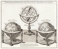
Png hand drawn globe sticker, vintage illustration on ripped paper, transparent background![Schematismus geographiae mathematicae, id est repraesentatio (1753) by Johann Baptista Homann. Original from The…]() Schematismus geographiae mathematicae, id est repraesentatio (1753) by Johann Baptista Homann. Original from The…
Schematismus geographiae mathematicae, id est repraesentatio (1753) by Johann Baptista Homann. Original from The…![Hemelkaart van de baan van de zon rond de aarde, volgens Ptolemaeus (ca. 1660 or 1708) by Pieter Schenk (I). Original from…]() Hemelkaart van de baan van de zon rond de aarde, volgens Ptolemaeus (ca. 1660 or 1708) by Pieter Schenk (I). Original from…
Hemelkaart van de baan van de zon rond de aarde, volgens Ptolemaeus (ca. 1660 or 1708) by Pieter Schenk (I). Original from…![Planisphaerivm Aratevm sive Compages Orbivm Mvndanorvm ex hypothesi Aratea in plano expressa (ca. 1708) by Andreas…]() Planisphaerivm Aratevm sive Compages Orbivm Mvndanorvm ex hypothesi Aratea in plano expressa (ca. 1708) by Andreas…
Planisphaerivm Aratevm sive Compages Orbivm Mvndanorvm ex hypothesi Aratea in plano expressa (ca. 1708) by Andreas…![Les Isles Britanniques: ou sont le Royaume d'Angleterre tire ́de Sped celuy d'Ecosse tire ́de Th. Pont et celuy d'Irlande…]() Les Isles Britanniques: ou sont le Royaume d'Angleterre tire ́de Sped celuy d'Ecosse tire ́de Th. Pont et celuy d'Irlande…
Les Isles Britanniques: ou sont le Royaume d'Angleterre tire ́de Sped celuy d'Ecosse tire ́de Th. Pont et celuy d'Irlande…![Kaart van Nederland met de marsroutes van het Franse leger (1792) by Cornelis van Baarsel. Original from The Rijksmuseum.…]() Kaart van Nederland met de marsroutes van het Franse leger (1792) by Cornelis van Baarsel. Original from The Rijksmuseum.…
Kaart van Nederland met de marsroutes van het Franse leger (1792) by Cornelis van Baarsel. Original from The Rijksmuseum.…![Getekende kaart van de Franse linies in Brabant (ca. 1705) by anonymous. Original from The Rijksmuseum. Digitally enhanced…]() Getekende kaart van de Franse linies in Brabant (ca. 1705) by anonymous. Original from The Rijksmuseum. Digitally enhanced…
Getekende kaart van de Franse linies in Brabant (ca. 1705) by anonymous. Original from The Rijksmuseum. Digitally enhanced…![Map of Africa (1722). Original from The Beinecke Rare Book & Manuscript Library. Digitally enhanced by rawpixel.]() Map of Africa (1722). Original from The Beinecke Rare Book & Manuscript Library. Digitally enhanced by rawpixel.
Map of Africa (1722). Original from The Beinecke Rare Book & Manuscript Library. Digitally enhanced by rawpixel.![Map of Vienna (ca. 1702) by Johann-Baptista Homann. Original from Yale University Art Gallery. Digitally enhanced by…]() Map of Vienna (ca. 1702) by Johann-Baptista Homann. Original from Yale University Art Gallery. Digitally enhanced by…
Map of Vienna (ca. 1702) by Johann-Baptista Homann. Original from Yale University Art Gallery. Digitally enhanced by…![Kaart van het zuidelijke deel van Zuid-Amerika (1750–1760) by Guillaume Delisle. Original from The Rijksmuseum.…]() Kaart van het zuidelijke deel van Zuid-Amerika (1750–1760) by Guillaume Delisle. Original from The Rijksmuseum.…
Kaart van het zuidelijke deel van Zuid-Amerika (1750–1760) by Guillaume Delisle. Original from The Rijksmuseum.…![Plattegrond van Béthune (1710) by anonymous. Original from The Rijksmuseum. Digitally enhanced by rawpixel.]() Plattegrond van Béthune (1710) by anonymous. Original from The Rijksmuseum. Digitally enhanced by rawpixel.
Plattegrond van Béthune (1710) by anonymous. Original from The Rijksmuseum. Digitally enhanced by rawpixel.![Hemelkaart met de noordelijke en zuidelijke sterrenbeelden (1705) by Pieter Schenk (I). Original from The Rijksmuseum.…]() Hemelkaart met de noordelijke en zuidelijke sterrenbeelden (1705) by Pieter Schenk (I). Original from The Rijksmuseum.…
Hemelkaart met de noordelijke en zuidelijke sterrenbeelden (1705) by Pieter Schenk (I). Original from The Rijksmuseum.…![Kaart van de aarde met de verschillende standen van de maan en de zon (1708) by Johannes van Loon. Original from The…]() Kaart van de aarde met de verschillende standen van de maan en de zon (1708) by Johannes van Loon. Original from The…
Kaart van de aarde met de verschillende standen van de maan en de zon (1708) by Johannes van Loon. Original from The…![A Map of the Winds (1740) by Matthaeo Seuttero. Original from The Beinecke Rare Book & Manuscript Library. Digitally…]() A Map of the Winds (1740) by Matthaeo Seuttero. Original from The Beinecke Rare Book & Manuscript Library. Digitally…
A Map of the Winds (1740) by Matthaeo Seuttero. Original from The Beinecke Rare Book & Manuscript Library. Digitally…![Map of Asia. Identical to the maps of Guillaume D'Isle (ca.1723). Original from British Library. Digitally enhanced by…]() Map of Asia. Identical to the maps of Guillaume D'Isle (ca.1723). Original from British Library. Digitally enhanced by…
Map of Asia. Identical to the maps of Guillaume D'Isle (ca.1723). Original from British Library. Digitally enhanced by…![Environmental awareness sticker, editable design set]() Environmental awareness sticker, editable design set
Environmental awareness sticker, editable design setTrending Design
![La pianta grande di Roma (The Large Plan of Rome), also known as The Nolli Map by Pietro Campana, Carlo Nolli, and Rocco…]() La pianta grande di Roma (The Large Plan of Rome), also known as The Nolli Map by Pietro Campana, Carlo Nolli, and Rocco…
La pianta grande di Roma (The Large Plan of Rome), also known as The Nolli Map by Pietro Campana, Carlo Nolli, and Rocco…![A new map of the world [cartographic material]: from the latest observations (1720) by John Senex. Original from The…]() A new map of the world [cartographic material]: from the latest observations (1720) by John Senex. Original from The…
A new map of the world [cartographic material]: from the latest observations (1720) by John Senex. Original from The…![Sterrenkaart van de noordelijke sterrenhemel (ca. 1722–1750) by Carel Allard. Original from The Rijksmuseum. Digitally…]() Sterrenkaart van de noordelijke sterrenhemel (ca. 1722–1750) by Carel Allard. Original from The Rijksmuseum. Digitally…
Sterrenkaart van de noordelijke sterrenhemel (ca. 1722–1750) by Carel Allard. Original from The Rijksmuseum. Digitally…![Plattegrond van Amsterdam met verdeling in halve brigades en bataljons van de Nationale Garde (1795) by Cornelis van…]() Plattegrond van Amsterdam met verdeling in halve brigades en bataljons van de Nationale Garde (1795) by Cornelis van…
Plattegrond van Amsterdam met verdeling in halve brigades en bataljons van de Nationale Garde (1795) by Cornelis van…![Kaart van Noord-Amerika (1735) from erven J. Ratelband & Co. Original from The Rijksmuseum. Digitally enhanced by rawpixel.]() Kaart van Noord-Amerika (1735) from erven J. Ratelband & Co. Original from The Rijksmuseum. Digitally enhanced by rawpixel.
Kaart van Noord-Amerika (1735) from erven J. Ratelband & Co. Original from The Rijksmuseum. Digitally enhanced by rawpixel.![Kaart van Zeeland (1677–1720) by anonymous. Original from The Rijksmuseum. Digitally enhanced by rawpixel.]() Kaart van Zeeland (1677–1720) by anonymous. Original from The Rijksmuseum. Digitally enhanced by rawpixel.
Kaart van Zeeland (1677–1720) by anonymous. Original from The Rijksmuseum. Digitally enhanced by rawpixel.![Map of China by Katsushika Hokusai (1760–1849). Original from Yale University Art Gallery. Digitally enhanced by…]() Map of China by Katsushika Hokusai (1760–1849). Original from Yale University Art Gallery. Digitally enhanced by…
Map of China by Katsushika Hokusai (1760–1849). Original from Yale University Art Gallery. Digitally enhanced by…![Plattegrond van Parijs (ca. 1721–1774) by Guillaume Delisle. Original from The Rijksmuseum. Digitally enhanced by…]() Plattegrond van Parijs (ca. 1721–1774) by Guillaume Delisle. Original from The Rijksmuseum. Digitally enhanced by…
Plattegrond van Parijs (ca. 1721–1774) by Guillaume Delisle. Original from The Rijksmuseum. Digitally enhanced by…![John Speede's British Isle Map (1770). Original public domain image from The Smithsonian Institution.]() John Speede's British Isle Map (1770). Original public domain image from The Smithsonian Institution.
John Speede's British Isle Map (1770). Original public domain image from The Smithsonian Institution.![Wereldkaart Mapemonde planisphere ou carte generale du monde (1735) from Daniel de Lafeuilledelete. Original from The…]() Wereldkaart Mapemonde planisphere ou carte generale du monde (1735) from Daniel de Lafeuilledelete. Original from The…
Wereldkaart Mapemonde planisphere ou carte generale du monde (1735) from Daniel de Lafeuilledelete. Original from The…![Sterrenkaart van de zuidelijke sterrenhemel (ca. 1722–1750) by Carel Allard. Original from The Rijksmuseum. Digitally…]() Sterrenkaart van de zuidelijke sterrenhemel (ca. 1722–1750) by Carel Allard. Original from The Rijksmuseum. Digitally…
Sterrenkaart van de zuidelijke sterrenhemel (ca. 1722–1750) by Carel Allard. Original from The Rijksmuseum. Digitally…![Vlakke aard-kloot met het beide hemelsch half-rond, of de onder scheidene verbeelding van de land-water-waereld (1709) by…]() Vlakke aard-kloot met het beide hemelsch half-rond, of de onder scheidene verbeelding van de land-water-waereld (1709) by…
Vlakke aard-kloot met het beide hemelsch half-rond, of de onder scheidene verbeelding van de land-water-waereld (1709) by…![A Map of the World from the best Authorities (1795) from Carey's American Edition of Guthrie's Geography Improved. Original…]() A Map of the World from the best Authorities (1795) from Carey's American Edition of Guthrie's Geography Improved. Original…
A Map of the World from the best Authorities (1795) from Carey's American Edition of Guthrie's Geography Improved. Original…![New world or western hemisphere: old world or eastern hemisphere (1786) by William Faden. Original from The Beinecke Rare…]() New world or western hemisphere: old world or eastern hemisphere (1786) by William Faden. Original from The Beinecke Rare…
New world or western hemisphere: old world or eastern hemisphere (1786) by William Faden. Original from The Beinecke Rare…![A new map of the world according to the new observations (1732) by Herman Moll. Original from The Beinecke Rare Book &…]() A new map of the world according to the new observations (1732) by Herman Moll. Original from The Beinecke Rare Book &…
A new map of the world according to the new observations (1732) by Herman Moll. Original from The Beinecke Rare Book &…![Planiglobii terrestris mappa vniversalis (1746) by George Moritz, Johann Matthias Hase, and Homann Erben. Original from The…]() Planiglobii terrestris mappa vniversalis (1746) by George Moritz, Johann Matthias Hase, and Homann Erben. Original from The…
Planiglobii terrestris mappa vniversalis (1746) by George Moritz, Johann Matthias Hase, and Homann Erben. Original from The…![Mappa totius mundi : adornata juxta observationes dnn. academiae regalis scientiarum et nonnullorum aliorum secundum…]() Mappa totius mundi : adornata juxta observationes dnn. academiae regalis scientiarum et nonnullorum aliorum secundum…
Mappa totius mundi : adornata juxta observationes dnn. academiae regalis scientiarum et nonnullorum aliorum secundum…![Four diagrams of Solar eclipses (1711) by Johannes Buno. Original from Library of Congress. Digitally enhanced by rawpixel.]() Four diagrams of Solar eclipses (1711) by Johannes Buno. Original from Library of Congress. Digitally enhanced by rawpixel.
Four diagrams of Solar eclipses (1711) by Johannes Buno. Original from Library of Congress. Digitally enhanced by rawpixel.![New World, or, Western Hemisphere; Old World, or Eastern Hemisphere (1790) by William Faden. Original From The New York…]() New World, or, Western Hemisphere; Old World, or Eastern Hemisphere (1790) by William Faden. Original From The New York…
New World, or, Western Hemisphere; Old World, or Eastern Hemisphere (1790) by William Faden. Original From The New York…![Mappe Monde ou Carte générale de l'Univers (1782) by Mathieu Albert Lotter. Original from The Beinecke Rare Book &…]() Mappe Monde ou Carte générale de l'Univers (1782) by Mathieu Albert Lotter. Original from The Beinecke Rare Book &…
Mappe Monde ou Carte générale de l'Univers (1782) by Mathieu Albert Lotter. Original from The Beinecke Rare Book &…![Nova & accuratissima totius terrarum orbis tabula nautica variationum magneticarum index juxta observationes Anno 1700…]() Nova & accuratissima totius terrarum orbis tabula nautica variationum magneticarum index juxta observationes Anno 1700…
Nova & accuratissima totius terrarum orbis tabula nautica variationum magneticarum index juxta observationes Anno 1700…![Planiglobii Terrestris Mappa Universalis (1746) by Johann Baptist Homann. Original from The MET Museum. Digitally enhanced…]() Planiglobii Terrestris Mappa Universalis (1746) by Johann Baptist Homann. Original from The MET Museum. Digitally enhanced…
Planiglobii Terrestris Mappa Universalis (1746) by Johann Baptist Homann. Original from The MET Museum. Digitally enhanced…![Jardin Public, Champs Elysées byCharles Motte (1785–1836). Original from The MET Museum. Digitally enhanced by…]() Jardin Public, Champs Elysées byCharles Motte (1785–1836). Original from The MET Museum. Digitally enhanced by…
Jardin Public, Champs Elysées byCharles Motte (1785–1836). Original from The MET Museum. Digitally enhanced by…![New twelve inch terrestrial globe (ca. 1891) by Rand McNally & Company. Original from Library of Congress. Digitally…]() New twelve inch terrestrial globe (ca. 1891) by Rand McNally & Company. Original from Library of Congress. Digitally…
New twelve inch terrestrial globe (ca. 1891) by Rand McNally & Company. Original from Library of Congress. Digitally…![Noua, et integra uniuersi orbis descriptio (1531) by Oronce Finé. Original from Library of Congress. Digitally…]() Noua, et integra uniuersi orbis descriptio (1531) by Oronce Finé. Original from Library of Congress. Digitally…
Noua, et integra uniuersi orbis descriptio (1531) by Oronce Finé. Original from Library of Congress. Digitally…![Map of New York and Vicinity (1869) by Matthew Dripps. Original from Library of Congress. Digitally enhanced by rawpixel.]() Map of New York and Vicinity (1869) by Matthew Dripps. Original from Library of Congress. Digitally enhanced by rawpixel.
Map of New York and Vicinity (1869) by Matthew Dripps. Original from Library of Congress. Digitally enhanced by rawpixel.![British Islands approximate positions of minefields (1918) by William Rea Furlong. Original from Library of Congress.…]() British Islands approximate positions of minefields (1918) by William Rea Furlong. Original from Library of Congress.…
British Islands approximate positions of minefields (1918) by William Rea Furlong. Original from Library of Congress.…![Bacon's standard map of Europe by George Washington Bacon (1830–1922). Original from Library of Congress. Digitally…]() Bacon's standard map of Europe by George Washington Bacon (1830–1922). Original from Library of Congress. Digitally…
Bacon's standard map of Europe by George Washington Bacon (1830–1922). Original from Library of Congress. Digitally…![Sanborn Fire Insurance Map from Brooklyn, Kings County, New York (1888) by Sanborn Map Company. Original from Library of…]() Sanborn Fire Insurance Map from Brooklyn, Kings County, New York (1888) by Sanborn Map Company. Original from Library of…
Sanborn Fire Insurance Map from Brooklyn, Kings County, New York (1888) by Sanborn Map Company. Original from Library of…![Portolan atlas of the Mediterranean Sea, western Europe, and the northwest coast of Africa: Central Mediterranean (ca. 1590)…]() Portolan atlas of the Mediterranean Sea, western Europe, and the northwest coast of Africa: Central Mediterranean (ca. 1590)…
Portolan atlas of the Mediterranean Sea, western Europe, and the northwest coast of Africa: Central Mediterranean (ca. 1590)…![Portolan atlas of the Mediterranean Sea, western Europe, and the northwest coast of Africa: Eastern Mediterranean (ca. 1590)…]() Portolan atlas of the Mediterranean Sea, western Europe, and the northwest coast of Africa: Eastern Mediterranean (ca. 1590)…
Portolan atlas of the Mediterranean Sea, western Europe, and the northwest coast of Africa: Eastern Mediterranean (ca. 1590)…![Map of the city of New York (ca. 1850) from Library of Congress Geography and Map Division Washington. Original from Library…]() Map of the city of New York (ca. 1850) from Library of Congress Geography and Map Division Washington. Original from Library…
Map of the city of New York (ca. 1850) from Library of Congress Geography and Map Division Washington. Original from Library…![A new and accurate map of the country for twenty five miles round the University of Oxford: exhibiting all the direct and…]() A new and accurate map of the country for twenty five miles round the University of Oxford: exhibiting all the direct and…
A new and accurate map of the country for twenty five miles round the University of Oxford: exhibiting all the direct and…![Globe Illustration from Éléments de géographie rédigés suivant les programmes de l'enseignement primaire (1881) by…]() Globe Illustration from Éléments de géographie rédigés suivant les programmes de l'enseignement primaire (1881) by…
Globe Illustration from Éléments de géographie rédigés suivant les programmes de l'enseignement primaire (1881) by…![Rapid transit map of Manhattan and adjacent districts of New York City (1908) by Rand McNally and Company. Original from…]() Rapid transit map of Manhattan and adjacent districts of New York City (1908) by Rand McNally and Company. Original from…
Rapid transit map of Manhattan and adjacent districts of New York City (1908) by Rand McNally and Company. Original from…![Hemelkaart van het stelsel van Copernicus (1708) by Pieter Schenk (I). Original from The Rijksmuseum. Digitally enhanced by…]() Hemelkaart van het stelsel van Copernicus (1708) by Pieter Schenk (I). Original from The Rijksmuseum. Digitally enhanced by…
Hemelkaart van het stelsel van Copernicus (1708) by Pieter Schenk (I). Original from The Rijksmuseum. Digitally enhanced by…![Portolan atlas of the Mediterranean Sea, western Europe, and the northwest coast of Africa: World map drawn on an oval…]() Portolan atlas of the Mediterranean Sea, western Europe, and the northwest coast of Africa: World map drawn on an oval…
Portolan atlas of the Mediterranean Sea, western Europe, and the northwest coast of Africa: World map drawn on an oval…![Image taken by a new Earth-observing instrument installed on the international space station. Original from NASA. Digitally…]() Image taken by a new Earth-observing instrument installed on the international space station. Original from NASA. Digitally…
Image taken by a new Earth-observing instrument installed on the international space station. Original from NASA. Digitally…![Missionary map of the world showing prevailing religions of its various nations and the central stations of all Protestant…]() Missionary map of the world showing prevailing religions of its various nations and the central stations of all Protestant…
Missionary map of the world showing prevailing religions of its various nations and the central stations of all Protestant…![The cartographic report by James Basire (1769-1822) of his majesty’s woods, forests, and land revenues. Original from…]() The cartographic report by James Basire (1769-1822) of his majesty’s woods, forests, and land revenues. Original from…
The cartographic report by James Basire (1769-1822) of his majesty’s woods, forests, and land revenues. Original from…![A map of Carolina, Florida and the Bahama Islands with the adjacent parts from The Natural History of Carolina, Florida, and…]() A map of Carolina, Florida and the Bahama Islands with the adjacent parts from The Natural History of Carolina, Florida, and…
A map of Carolina, Florida and the Bahama Islands with the adjacent parts from The Natural History of Carolina, Florida, and…![Parts of he Kimberley region of Western Australia. Original from NASA. Digitally enhanced by rawpixel.]() Parts of he Kimberley region of Western Australia. Original from NASA. Digitally enhanced by rawpixel.
Parts of he Kimberley region of Western Australia. Original from NASA. Digitally enhanced by rawpixel.![The Sustina Glacier in the Alaska Range. Original from NASA. Digitally enhanced by rawpixel.]() The Sustina Glacier in the Alaska Range. Original from NASA. Digitally enhanced by rawpixel.
The Sustina Glacier in the Alaska Range. Original from NASA. Digitally enhanced by rawpixel.![Ellesmere Island, which is part of the Qikiqtaaluk Region of the Canadian territory of Nunavut. Original from NASA.…]() Ellesmere Island, which is part of the Qikiqtaaluk Region of the Canadian territory of Nunavut. Original from NASA.…
Ellesmere Island, which is part of the Qikiqtaaluk Region of the Canadian territory of Nunavut. Original from NASA.…![Thailand floods monitored by a NASA satellite. Original from NASA. Digitally enhanced by rawpixel.]() Thailand floods monitored by a NASA satellite. Original from NASA. Digitally enhanced by rawpixel.
Thailand floods monitored by a NASA satellite. Original from NASA. Digitally enhanced by rawpixel.![Myiabeillia typica (Abeille's Hummingbird) print in high resolution by John Gould (1804–1881) and Henry Constantine…]() Myiabeillia typica (Abeille's Hummingbird) print in high resolution by John Gould (1804–1881) and Henry Constantine…
Myiabeillia typica (Abeille's Hummingbird) print in high resolution by John Gould (1804–1881) and Henry Constantine…![From the book, Panckoucke Methodical Encyclopedia, published in 1784, an antique drawing of a compass-like watchmaking tool.…]() From the book, Panckoucke Methodical Encyclopedia, published in 1784, an antique drawing of a compass-like watchmaking tool.…
From the book, Panckoucke Methodical Encyclopedia, published in 1784, an antique drawing of a compass-like watchmaking tool.…![Vintage Victorian style compass engraving. Original from the British Library. Digitally enhanced by rawpixel.]() Vintage Victorian style compass engraving. Original from the British Library. Digitally enhanced by rawpixel.
Vintage Victorian style compass engraving. Original from the British Library. Digitally enhanced by rawpixel.![Vintage Victorian style compass engraving. Original from the British Library. Digitally enhanced by rawpixel.]() Vintage Victorian style compass engraving. Original from the British Library. Digitally enhanced by rawpixel.
Vintage Victorian style compass engraving. Original from the British Library. Digitally enhanced by rawpixel.![The Musandam Peninsula, part of Oman. Original from NASA. Digitally enhanced by rawpixel.]() The Musandam Peninsula, part of Oman. Original from NASA. Digitally enhanced by rawpixel.
The Musandam Peninsula, part of Oman. Original from NASA. Digitally enhanced by rawpixel.![New image of the Earth at night is a composite assembled from data acquired by the Suomi National Polar-orbiting Partnership…]() New image of the Earth at night is a composite assembled from data acquired by the Suomi National Polar-orbiting Partnership…
New image of the Earth at night is a composite assembled from data acquired by the Suomi National Polar-orbiting Partnership…![Delhi, the second largest metropolis in India, with a population of 16 million. Original from NASA. Digitally enhanced by…]() Delhi, the second largest metropolis in India, with a population of 16 million. Original from NASA. Digitally enhanced by…
Delhi, the second largest metropolis in India, with a population of 16 million. Original from NASA. Digitally enhanced by…![Flood waters in Bangkok as the Ayutthaya River overflowed its banks. Original from NASA. Digitally enhanced by rawpixel.]() Flood waters in Bangkok as the Ayutthaya River overflowed its banks. Original from NASA. Digitally enhanced by rawpixel.
Flood waters in Bangkok as the Ayutthaya River overflowed its banks. Original from NASA. Digitally enhanced by rawpixel.![Aaland archipelago at the mouth of the Gulf of Bothnia which belongs to Finland. Original from NASA. Digitally enhanced by…]() Aaland archipelago at the mouth of the Gulf of Bothnia which belongs to Finland. Original from NASA. Digitally enhanced by…
Aaland archipelago at the mouth of the Gulf of Bothnia which belongs to Finland. Original from NASA. Digitally enhanced by…![Brasilia, the capital of Brazil. Original from NASA. Digitally enhanced by rawpixel.]() Brasilia, the capital of Brazil. Original from NASA. Digitally enhanced by rawpixel.
Brasilia, the capital of Brazil. Original from NASA. Digitally enhanced by rawpixel.![Jamestown, located on Jamestown Island in the Virginia Colony. Original from NASA. Digitally enhanced by rawpixel.]() Jamestown, located on Jamestown Island in the Virginia Colony. Original from NASA. Digitally enhanced by rawpixel.
Jamestown, located on Jamestown Island in the Virginia Colony. Original from NASA. Digitally enhanced by rawpixel.![Pensylvania Nova Jersey et Nova York cum regionibus ad fluvium Delaware in America sitis, ... (1778) by Lotter, Tobias Conrad]() Pensylvania Nova Jersey et Nova York cum regionibus ad fluvium Delaware in America sitis, ... (1778) by Lotter, Tobias Conrad
Pensylvania Nova Jersey et Nova York cum regionibus ad fluvium Delaware in America sitis, ... (1778) by Lotter, Tobias Conrad![Map of the Earth 1681. Original public domain image from Wikipedia. Digitally enhanced by rawpixel.]() Map of the Earth 1681. Original public domain image from Wikipedia. Digitally enhanced by rawpixel.
Map of the Earth 1681. Original public domain image from Wikipedia. Digitally enhanced by rawpixel.![Bacon's standard map of Europe illustration, artwork by George Washington Bacon, remixed by rawpixel]() Bacon's standard map of Europe illustration, artwork by George Washington Bacon, remixed by rawpixel
Bacon's standard map of Europe illustration, artwork by George Washington Bacon, remixed by rawpixel![Heilongjiang, a province of China located in the northeastern part of the country. Original from NASA. Digitally enhanced by…]() Heilongjiang, a province of China located in the northeastern part of the country. Original from NASA. Digitally enhanced by…
Heilongjiang, a province of China located in the northeastern part of the country. Original from NASA. Digitally enhanced by…![Sakhalin Island, located just north of Japan and east of the Khabarovski and Primorski Krai of the Russian Far East.…]() Sakhalin Island, located just north of Japan and east of the Khabarovski and Primorski Krai of the Russian Far East.…
Sakhalin Island, located just north of Japan and east of the Khabarovski and Primorski Krai of the Russian Far East.…![The Channel Tunnel, a 50.5 km-long rail tunnel beneath the English Channel at the Straits of Dover. Original from NASA.…]() The Channel Tunnel, a 50.5 km-long rail tunnel beneath the English Channel at the Straits of Dover. Original from NASA.…
The Channel Tunnel, a 50.5 km-long rail tunnel beneath the English Channel at the Straits of Dover. Original from NASA.…![Earth observations taken from Space Shuttle Columbia during STS-93 mission. Original from NASA. Digitally enhanced by…]() Earth observations taken from Space Shuttle Columbia during STS-93 mission. Original from NASA. Digitally enhanced by…
Earth observations taken from Space Shuttle Columbia during STS-93 mission. Original from NASA. Digitally enhanced by…![The Zambezi, the fourth largest river in Africa, and the largest east-flowing waterway. Original from NASA. Digitally…]() The Zambezi, the fourth largest river in Africa, and the largest east-flowing waterway. Original from NASA. Digitally…
The Zambezi, the fourth largest river in Africa, and the largest east-flowing waterway. Original from NASA. Digitally…![Guangxi Province in southeast China. Original from NASA. Digitally enhanced by rawpixel.]() Guangxi Province in southeast China. Original from NASA. Digitally enhanced by rawpixel.
Guangxi Province in southeast China. Original from NASA. Digitally enhanced by rawpixel.![Flooding from the Chao Phraya River, Thailand on Nov. 1, 2011. Original from NASA. Digitally enhanced by rawpixel.]() Flooding from the Chao Phraya River, Thailand on Nov. 1, 2011. Original from NASA. Digitally enhanced by rawpixel.
Flooding from the Chao Phraya River, Thailand on Nov. 1, 2011. Original from NASA. Digitally enhanced by rawpixel.![The flooding from the Chao Phraya River, Thailand on Nov. 17, 2011. Original from NASA. Digitally enhanced by rawpixel.]() The flooding from the Chao Phraya River, Thailand on Nov. 17, 2011. Original from NASA. Digitally enhanced by rawpixel.
The flooding from the Chao Phraya River, Thailand on Nov. 17, 2011. Original from NASA. Digitally enhanced by rawpixel.![View of the Himalaya Mountain Range in the India-Nepal-Tibet border area. Original from NASA. Digitally enhanced by rawpixel.]() View of the Himalaya Mountain Range in the India-Nepal-Tibet border area. Original from NASA. Digitally enhanced by rawpixel.
View of the Himalaya Mountain Range in the India-Nepal-Tibet border area. Original from NASA. Digitally enhanced by rawpixel.![The northernmost land in the world is located in Pearyland, Greenland. Original from NASA. Digitally enhanced by rawpixel.]() The northernmost land in the world is located in Pearyland, Greenland. Original from NASA. Digitally enhanced by rawpixel.
The northernmost land in the world is located in Pearyland, Greenland. Original from NASA. Digitally enhanced by rawpixel.![Image from NASA's Terra spacecraft of Franz Josef Land, an archipelago in the far north of Russia. Original from NASA.…]() Image from NASA's Terra spacecraft of Franz Josef Land, an archipelago in the far north of Russia. Original from NASA.…
Image from NASA's Terra spacecraft of Franz Josef Land, an archipelago in the far north of Russia. Original from NASA.…![Santo Domingo, the capital of the Dominican Republic. Original from NASA. Digitally enhanced by rawpixel.]() Santo Domingo, the capital of the Dominican Republic. Original from NASA. Digitally enhanced by rawpixel.
Santo Domingo, the capital of the Dominican Republic. Original from NASA. Digitally enhanced by rawpixel.