Full Mir over New Zealand, from the space shuttle Atlantis, Russia's Mir Space Station. Original from NASA. Digitally… https://www.rawpixel.com/image/441571/free-photo-image-new-zealand-maps-satellite-public-domain Free Image from public domain license
Southwestern US, with Las Vegas, NV in foreground, June 27, 1965. Original from NASA. Digitally enhanced by rawpixel. https://www.rawpixel.com/image/441657/free-photo-image-nasa-satellite-view-apollo Free Image from public domain license
Earth observations taken during STS-77 mission. Original from NASA. Digitally enhanced by rawpixel. https://www.rawpixel.com/image/441615/free-photo-image-nasa-maps-ocean Free Image from public domain license
Aaland archipelago at the mouth of the Gulf of Bothnia which belongs to Finland. Original from NASA. Digitally enhanced by… https://www.rawpixel.com/image/441242/free-photo-image-nasa-nasa-earth-helsinki Free Image from public domain license
Brasilia, the capital of Brazil. Original from NASA. Digitally enhanced by rawpixel. https://www.rawpixel.com/image/441221/free-photo-image-brazil-brasilia-city-map Free Image from public domain license
Earth observations taken from Space Shuttle Columbia during STS-93 mission. Original from NASA. Digitally enhanced by… https://www.rawpixel.com/image/441583/free-photo-image-fire-rainforest-climate-change Free Image from public domain license
These rocks are famous because they move, leaving tell-tale trails in the clay, like this one. Original from NASA. Digitally… https://www.rawpixel.com/image/440250/free-photo-image-death-valley-global-warming-change-world Free Image from public domain license
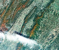
Mountain ridges showing the distinctive geology of the Geikie Plateau region in eastern Greenland. Original from NASA.… https://www.rawpixel.com/image/440139/the-geikie-plateau Free Image from public domain license
After school program Instagram post template, editable text https://www.rawpixel.com/image/12739103/after-school-program-instagram-post-template-editable-text View license Trending Design
View of Florence, Italy area from the Skylab. Original from NASA. Digitally enhanced by rawpixel. https://www.rawpixel.com/image/441546/free-photo-image-nasa-map-florence Free Image from public domain license
Santo Domingo, the capital of the Dominican Republic. Original from NASA. Digitally enhanced by rawpixel. https://www.rawpixel.com/image/440567/free-photo-image-dominican-republic-christopher-columbus Free Image from public domain license
Ellesmere Island, which is part of the Qikiqtaaluk Region of the Canadian territory of Nunavut. Original from NASA.… https://www.rawpixel.com/image/440667/free-photo-image-maps-nasa-earth-map Free Image from public domain license
Image from NASA's Terra spacecraft of Franz Josef Land, an archipelago in the far north of Russia. Original from NASA.… https://www.rawpixel.com/image/441324/free-photo-image-maps-nasa-russia Free Image from public domain license
The Sustina Glacier in the Alaska Range. Original from NASA. Digitally enhanced by rawpixel. https://www.rawpixel.com/image/441244/free-photo-image-nasa-maps-valley Free Image from public domain license
NASA satellite tracks underwater volcanic eruption in Canary Islands. Original from NASA. Digitally enhanced by rawpixel. https://www.rawpixel.com/image/441274/free-photo-image-ocean-underwater-climate-change Free Image from public domain license
Lake Mackay, the largest of hundreds of ephemeral lakes scattered throughout Western Australia and the Northern Territory.… https://www.rawpixel.com/image/440591/free-photo-image-nasa-map-earth Free Image from public domain license
Earth observations of Houston taken by STS-115 crew member. Original from NASA. Digitally enhanced by rawpixel. https://www.rawpixel.com/image/441285/free-photo-image-stadium-satellite-view-historical-maps Free Image from public domain license
Thailand floods monitored by a NASA satellite. Original from NASA. Digitally enhanced by rawpixel. https://www.rawpixel.com/image/441275/free-photo-image-nasa-map-river-bank Free Image from public domain license
Grand Turk Island is an island in the Turks and Caicos Islands in the Caribbean, and contains the territory's capital… https://www.rawpixel.com/image/441237/free-photo-image-nasa-2001-maps Free Image from public domain license
Jamestown, located on Jamestown Island in the Virginia Colony. Original from NASA. Digitally enhanced by rawpixel. https://www.rawpixel.com/image/441199/jamestown-space-view Free Image from public domain license
Earth observations of Argentina and Chile was among several of South America. Original from NASA. Digitally enhanced by… https://www.rawpixel.com/image/441601/free-photo-image-argentina-nasa-climate-change Free Image from public domain license
Parts of he Kimberley region of Western Australia. Original from NASA. Digitally enhanced by rawpixel. https://www.rawpixel.com/image/440627/free-photo-image-australia-map-nasa Free Image from public domain license
Heilongjiang, a province of China located in the northeastern part of the country. Original from NASA. Digitally enhanced by… https://www.rawpixel.com/image/440587/heilongjiang-province-space-view Free Image from public domain license
The Channel Tunnel, a 50.5 km-long rail tunnel beneath the English Channel at the Straits of Dover. Original from NASA.… https://www.rawpixel.com/image/441134/channel-tunnel-space-view Free Image from public domain license
Oriente Province, eastern end of Cuba, as seen from the National Aeronautics and Space Administration's Gemini-7 spacecraft.… https://www.rawpixel.com/image/441745/free-photo-image-santiago-maps-map-background Free Image from public domain license
New image of the Earth at night is a composite assembled from data acquired by the Suomi National Polar-orbiting Partnership… https://www.rawpixel.com/image/440262/free-photo-image-map-world-background Free Image from public domain license
Flood waters in Bangkok as the Ayutthaya River overflowed its banks. Original from NASA. Digitally enhanced by rawpixel. https://www.rawpixel.com/image/440502/free-photo-image-maps-background-flood Free Image from public domain license
Delhi, the second largest metropolis in India, with a population of 16 million. Original from NASA. Digitally enhanced by… https://www.rawpixel.com/image/441145/free-photo-image-map-satellite-maps-public-domain-high-resolution-landscape Free Image from public domain license
Cornell University, Infrared Interferometer mission directors console. Original from NASA. Digitally enhanced by rawpixel. https://www.rawpixel.com/image/440063/free-photo-image-nasa-room-technology Free Image from public domain license
Climate change Instagram post template, editable text https://www.rawpixel.com/image/12058514/climate-change-instagram-post-template-editable-text View license Trending Design
Marie is the name of two cities on Saint Mary's River, separating Canada and the State of Michigan in the United States.… https://www.rawpixel.com/image/441228/free-photo-image-canada-michigan-climate-change Free Image from public domain license
Images of the Earth's land surface and surrounding coastal regions. Original from NASA. Digitally enhanced by rawpixel. https://www.rawpixel.com/image/440155/free-photo-image-nasa-map-seattle Free Image from public domain license
The Wilkins Ice Shelf on the western side of the Antarctic Peninsula. Original from NASA. Digitally enhanced by rawpixel. https://www.rawpixel.com/image/441236/free-photo-image-maps-snow-advanced-spaceborne-thermal-emission-and-reflection-radiometer-aster Free Image from public domain license
Guangxi Province in southeast China. Original from NASA. Digitally enhanced by rawpixel. https://www.rawpixel.com/image/440654/guangxi-provine-space-view Free Image from public domain license
The flooding from the Chao Phraya River, Thailand on Nov. 17, 2011. Original from NASA. Digitally enhanced by rawpixel. https://www.rawpixel.com/image/440511/free-photo-image-nasa-background-2011 Free Image from public domain license
Flooding from the Chao Phraya River, Thailand on Nov. 1, 2011. Original from NASA. Digitally enhanced by rawpixel. https://www.rawpixel.com/image/440508/free-photo-image-nasa-map-thailand Free Image from public domain license
View of the Himalaya Mountain Range in the India-Nepal-Tibet border area. Original from NASA. Digitally enhanced by rawpixel. https://www.rawpixel.com/image/441723/free-photo-image-india-maps-mountain Free Image from public domain license
The northernmost land in the world is located in Pearyland, Greenland. Original from NASA. Digitally enhanced by rawpixel. https://www.rawpixel.com/image/441198/free-photo-image-nasa-snow-greenland-nature Free Image from public domain license
Lake Torrens and the Australian Outback. Original from NASA. Digitally enhanced by rawpixel. https://www.rawpixel.com/image/441174/free-photo-image-australia-nasa-desert Free Image from public domain license
Typhoon Phanfone affecting Japan, on October 5, 2014. Original from NASA. Digitally enhanced by rawpixel. https://www.rawpixel.com/image/440100/free-photo-image-typhoon-nasa-japan Free Image from public domain license
Amazing image of the Earth.Original from NASA. Digitally enhanced by rawpixel. https://www.rawpixel.com/image/418671/free-photo-image-satellite-images-horizon-universe Free Image from public domain license
Island of Hawaii, State of Hawaii seen from Skylab. Original from NASA. Digitally enhanced by rawpixel. https://www.rawpixel.com/image/441611/free-photo-image-hawaii-volcano-island-maps Free Image from public domain license
Los Angeles and vicinity seen from space on May 4, 2001. Original from NASA. Digitally enhanced by rawpixel. https://www.rawpixel.com/image/440540/free-photo-image-topography-los-angeles-map-radar Free Image from public domain license
The central coastal area of Peru as seen from the Gemini-9A spacecraft. Original from NASA. Digitally enhanced by rawpixel https://www.rawpixel.com/image/441726/free-photo-image-peru-maps-satellite Free Image from public domain license
MODIS on the Aqua satellite captured this stunning view of Japans four largest islands on February 20, 2004. Original from… https://www.rawpixel.com/image/440157/free-photo-image-maps-satellite-public-domain Free Image from public domain license
New NASA laser technology reveals how ice measures up. Original from NASA. Digitally enhanced by rawpixel. https://www.rawpixel.com/image/440185/free-photo-image-greenland-snow-arctic-ocean Free Image from public domain license
Fog blankets the woods near a road in the Merritt Island National Wildlife Refuge at NASA's Kennedy Space Center in Florida.… https://www.rawpixel.com/image/440914/free-photo-image-florida-nasa-cape-canaveral Free Image from public domain license
Sakhalin Island, located just north of Japan and east of the Khabarovski and Primorski Krai of the Russian Far East.… https://www.rawpixel.com/image/441164/free-photo-image-japan-maps-japanese Free Image from public domain license
The Zambezi, the fourth largest river in Africa, and the largest east-flowing waterway. Original from NASA. Digitally… https://www.rawpixel.com/image/440595/zambezi-river-space-view Free Image from public domain license
Remote sensing of ocean color in the Yellow Sea. Original from NASA. Digitally enhanced by rawpixel. https://www.rawpixel.com/image/440150/free-photo-image-chinese-maps-nasa Free Image from public domain license
Hurricane Gonzalo's northern quadrant over Bermuda. Original from NASA. Digitally enhanced by rawpixel. https://www.rawpixel.com/image/440115/free-photo-image-hurricane-nasa-climate-change Free Image from public domain license
Sediment Transforms Lake Michigan, Original from NASA. Digitally enhanced by rawpixel. https://www.rawpixel.com/image/440733/free-photo-image-coastline-maps-public-domain Free Image from public domain license
View of Melbourne, Australia as seen from the Skylab space station. Original from NASA. Digitally enhanced by rawpixel. https://www.rawpixel.com/image/441570/free-photo-image-melbourne-australian-australia Free Image from public domain license
The Ouachita Mountains in southeast Oklahoma. Original from NASA. Digitally enhanced by rawpixel. https://www.rawpixel.com/image/441267/free-photo-image-nasa-map-oklahoma Free Image from public domain license
Mackenzie Bay, Antarctica and the ice shelf on February 12, 2012., Original from NASA. Digitally enhanced by rawpixel. https://www.rawpixel.com/image/440206/mackenzie-bay-antarctica-space-view Free Image from public domain license
The eastern hemisphere was captured on March 30, 2014, by the Visible Infrared Imaging Radiometer Suite on the Suomi NPP… https://www.rawpixel.com/image/440136/earth Free Image from public domain license
The Olympic National Park has to be one of America’s most diverse national park landscapes. Original from NASA.… https://www.rawpixel.com/image/440091/free-photo-image-satellite-nasa-olympic-national-park Free Image from public domain license
Phytoplankton bloom off Newfoundland. Original from NASA. Digitally enhanced by rawpixel. https://www.rawpixel.com/image/440201/phytoplankton-bloom-off-newfoundland Free Image from public domain license
NASA-NOAA's Suomi NPP Satellite Gets Colorful Look at Hurricane Blanca. Original from NASA. Digitally enhanced by rawpixel. https://www.rawpixel.com/image/440152/free-photo-image-hurricane-nasa-storm Free Image from public domain license
Glacier Grey in front of The Cuernos del Paine mountains in Chile. Original from NASA. Digitally enhanced by rawpixel. https://www.rawpixel.com/image/440054/free-photo-image-glacier-patagonia-chile Free Image from public domain license
Image of Tokyo Bay, Japan. Original from NASA. Digitally enhanced by rawpixel. https://www.rawpixel.com/image/441293/free-photo-image-tokyo-nasa-japan Free Image from public domain license
View of a cloudy earth shown from space. This particular image portrays the average of all of the satellite's cloud… https://www.rawpixel.com/image/440144/cloudy-earth Free Image from public domain license
Acadia National Park is one of the most visited parks in America. Original from NASA. Digitally enhanced by rawpixel. https://www.rawpixel.com/image/440092/free-photo-image-map-nasa-world Free Image from public domain license
The ice of a piedmont glacier spills from a steep valley onto a relatively flat plain. Malaspina Glacier, Alaska. Original… https://www.rawpixel.com/image/440088/free-photo-image-nasa-map-piedmont Free Image from public domain license
Hurricane Matthew. This is a visible image of Major Hurricane Matthew taken from NASA's Terra satellite on Oct. 7 at 12 p.m.… https://www.rawpixel.com/image/440032/free-photo-image-hurricane-disaster-map Free Image from public domain license
The world's largest bauxite mine found near Weipa, Queensland, Australia. Original from NASA. Digitally enhanced by rawpixel. https://www.rawpixel.com/image/440663/free-photo-image-1955-1960-aluminium Free Image from public domain license
The world largest bauxite mine found near Weipa, Queensland, Australia. Original from NASA. Digitally enhanced by rawpixel. https://www.rawpixel.com/image/439912/free-photo-image-water-conservation-australia-mountain Free Image from public domain license
Pyroclastic Flow Remnants at Shiveluch Volcano. Original from NASA. Digitally enhanced by rawpixel. https://www.rawpixel.com/image/440238/free-photo-image-avalanche-volcano-february-2011 Free Image from public domain license
The Mackenzie River in the Northwest Territories, Canada. Original from NASA. Digitally enhanced by rawpixel. https://www.rawpixel.com/image/439973/map-green-terrain-canada Free Image from public domain license
Akpatok Island in Ungava Bay in northern Quebec, Canada. Original from NASA. Digitally enhanced by rawpixel. https://www.rawpixel.com/image/440234/free-photo-image-water-maps-ice Free Image from public domain license
The city of Chateaubriant, France. Original from NASA. Digitally enhanced by rawpixel. https://www.rawpixel.com/image/441218/free-photo-image-city-satellite-climate-change-cc0 Free Image from public domain license
Image formed by the Advanced Spaceborne Thermal Emission and Reflection Radiometer (ASTER) and Global Digital Elevation… https://www.rawpixel.com/image/441205/free-photo-image-world-map-digital Free Image from public domain license
The Republic of Seychelles, an island country with an archipelago of 115 islands. Original from NASA. Digitally enhanced by… https://www.rawpixel.com/image/441306/free-photo-image-seychelles-archipelago-clouds-satellite Free Image from public domain license
Moon crossing in front of its view of the sun captured by NASA’s Solar Dynamics Observatory (SDO) on Jan 30th, 2014.… https://www.rawpixel.com/image/440149/free-photo-image-astrology-fire-eclipse Free Image from public domain license
Oslo, the capital and largest city in Norway. Original from NASA. Digitally enhanced by rawpixel. https://www.rawpixel.com/image/441269/free-photo-image-cc0-city-climate-change Free Image from public domain license
The Indonesian islands of Komodo, Rintja, Padar, and Flores in the Komodo National Park. Original from NASA. Digitally… https://www.rawpixel.com/image/441183/free-photo-image-flores-indonesian-nationality-dragon Free Image from public domain license
The Jizzax Province in eastern Uzbekistan. Original from NASA. Digitally enhanced by rawpixel. https://www.rawpixel.com/image/441256/free-photo-image-uzbekistan-agriculture-cc0 Free Image from public domain license
Nunavut, in northern Canada, the largest and newest federal territory of the country. Original from NASA. Digitally enhanced… https://www.rawpixel.com/image/440513/free-photo-image-nunavut-sea-grass-satellite Free Image from public domain license
Parts of the vast Ganges delta. Original from NASA. Digitally enhanced by rawpixel. https://www.rawpixel.com/image/440512/free-photo-image-bangladesh-india-nasa Free Image from public domain license
The Republic of Singapore, a city-state off the southern tip of the Malay Peninsula. Original from NASA. Digitally enhanced… https://www.rawpixel.com/image/441251/free-photo-image-singapore-satellite-images-malay Free Image from public domain license
NASA's Terra spacecraft captured this image of the city of Arkhangelsk and administrative capital of Archangelsk Oblast… https://www.rawpixel.com/image/441238/free-photo-image-river-map-landscape Free Image from public domain license
Satellite image of Earth. Original from NASA. Digitally enhanced by rawpixel. https://www.rawpixel.com/image/418620/free-photo-image-stars-space-nasa Free Image from public domain license
The city of Sukkur, Pakistan. Original from NASA. Digitally enhanced by rawpixel. https://www.rawpixel.com/image/441254/free-photo-image-flood-maps-august-2010 Free Image from public domain license
Satellite image of Earth. Original from NASA. Digitally enhanced by rawpixel. https://www.rawpixel.com/image/418623/free-photo-image-planet-earth-globe Free Image from public domain license
OES-13 Satellite Sees a Giant Apostrophe from Strong Eastern U.S. Low Pressure. Original from NASA . Digitally enhanced by… https://www.rawpixel.com/image/440228/free-photo-image-nasa-ocean-clouds-satellite Free Image from public domain license
Zircon mineral of 4.4 billion years old from a sedimentary gneiss in the Jack Hills of the Narre Gneiss Terrane of… https://www.rawpixel.com/image/441184/free-photo-image-australia-material-granite Free Image from public domain license
The McMurdo Dry Valleys are a row of valleys west of McMurdo Sound, Antarctica. They are so named because of their extremely… https://www.rawpixel.com/image/441193/free-photo-image-december-2002-antarctica-cc0 Free Image from public domain license
The Isle of Man. Original from NASA. Digitally enhanced by rawpixel. https://www.rawpixel.com/image/440568/free-photo-image-isle-man-ireland-great-britain Free Image from public domain license
Kamchatka Peninsula, Russia. Original from NASA. Digitally enhanced by rawpixel. https://www.rawpixel.com/image/440510/free-photo-image-russia-mystery-mysterious-island Free Image from public domain license
The western United States and Canada. Original from NASA. Digitally enhanced by rawpixel. https://www.rawpixel.com/image/440485/free-photo-image-climate-change-satellite-canada Free Image from public domain license
The first pass of Echo 1, America's first communications satellite, over the Goldstone Tracking Station in Pasadena… https://www.rawpixel.com/image/440672/communications-satellite Free Image from public domain license
Artist’s concept of the Orbiting Carbon Observatory. Original from NASA. Digitally enhanced by rawpixel. https://www.rawpixel.com/image/439979/free-photo-image-satellite-nasa-space-ship Free Image from public domain license
Area of Indian Ocean just east of the island of Madagascar. Original from NASA. Digitally enhanced by rawpixel. https://www.rawpixel.com/image/441756/indian-ocean Free Image from public domain license
The Lena River, some 2,800 miles long, is one of the largest rivers in the world. Original from NASA. Digitally enhanced by… https://www.rawpixel.com/image/440230/free-photo-image-nasa-russia-earth Free Image from public domain license
Ribbons of Saharan sand dunes seem to glow in sunset colors. Original from NASA. Digitally enhanced by rawpixel. https://www.rawpixel.com/image/440267/sand-dune-ribbons-the-sahara-desert Free Image from public domain license
Massive congregations of greenish phytoplankton swirl in the dark water around Gotland, a Swedish island in the Baltic Sea.… https://www.rawpixel.com/image/440200/free-photo-image-van-gogh-nasa-maps Free Image from public domain license
At NASA Kennedy Space Center's Visitor Complex, Star Trek memorabilia is being displayed. Original from NASA . Digitally… https://www.rawpixel.com/image/441014/free-photo-image-spaceship-star-trek-galaxy Free Image from public domain license