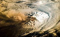
Kamchatka Peninsula, Russia. Original from NASA. Digitally enhanced by rawpixel. https://www.rawpixel.com/image/440510/free-photo-image-russia-mystery-mysterious-island Free Image from public domain license
Sheveluch Volcano in Kamchatka, Siberia. Original from NASA. Digitally enhanced by rawpixel. https://www.rawpixel.com/image/441226/free-photo-image-map-volcano-nasa Free Image from public domain license
A man from Kamchatka. Engraving by W. Sharp, 1784, after J. Webber. https://www.rawpixel.com/image/13997545/man-from-kamchatka-engraving-sharp-1784-after-webber Free Image from public domain license
A woman from Kamchatka wearing a scarf on her head. Engraving by W. Sharp, 1784, after J. Webber. https://www.rawpixel.com/image/13979812/image-face-person-art Free Image from public domain license
Arabian Peninsula and northeast Africa as seen from the orbiting Gemini-11. Original from NASA. Digitally enhanced by… https://www.rawpixel.com/image/441740/free-photo-image-africa-map-space-view Free Image from public domain license
The volcano of Awatcha (Avacha) in Kamchatka, Siberia. Etching with engraving. https://www.rawpixel.com/image/13992002/the-volcano-awatcha-avacha-kamchatka-siberia-etching-with-engraving Free Image from public domain license
Nadir view of the southern Cape District of South Africa. Original from NASA. Digitally enhanced by rawpixel. https://www.rawpixel.com/image/441620/free-photo-image-africa-south-cape-town Free Image from public domain license
The village of Bolsheretsk in Kamchatka, with some of its inhabitants . Engraving by P. Benazech, 1784, after J. Webber. https://www.rawpixel.com/image/14012038/image-dog-cloud-person Free Image from public domain license
Four summer houses and a winter dwelling in Kamchatka. Engraving by S. Smith, 1784, after J. Webber. https://www.rawpixel.com/image/13995317/image-dog-cloud-person Free Image from public domain license
The Kondyor Massif is located in Eastern Siberia, Russia, north of the city of Khabarovsk. Original from NASA. Digitally… https://www.rawpixel.com/image/441148/free-photo-image-map-nasa-russia Free Image from public domain license
A man travelling on a sledge drawn by five dogs in Kamchatka. Engraving by S. Middiman, 1784, after J. Webber. https://www.rawpixel.com/image/14002282/image-dog-horse-plant Free Image from public domain license
The interior of a winter dwelling in Kamchatka. Engraving by W. Sharp, 1784, after J. Webber. https://www.rawpixel.com/image/14001822/image-dog-cartoon-person Free Image from public domain license
Rostov-on-Don, a Russian City on the Don River, 32 kilometers from the Sea of Azov. Original from NASA. Digitally enhanced… https://www.rawpixel.com/image/440623/free-photo-image-nasa-map-world Free Image from public domain license
The town of Petropavlovsk-Kamchatsky. Engraving by B.T. Pouncy, 1784, after J. Webber. https://www.rawpixel.com/image/14010585/image-cloud-person-art Free Image from public domain license
This rare cloud-free view of southern Italy shows almost all of the famous `boot' configuration of the peninsula up to just… https://www.rawpixel.com/image/441789/free-photo-image-southern-italy-nasa-skylab Free Image from public domain license
Snow, which tends to be generally less bright that clouds, covers the Alps in the north of Italy. Original from NASA.… https://www.rawpixel.com/image/440140/free-photo-image-italy-map-maps Free Image from public domain license
Voyage en Sibérie, fait par ordre du roi en 1761. Contenant les mœurs, les usages des Russes, et l'etat actuel de cette… https://www.rawpixel.com/image/14001624/image-paper-cartoon-person Free Image from public domain license
View of the southeastern tip of the Arabian Peninsula with the Gulf of Oman at upper right. Original from NASA . Digitally… https://www.rawpixel.com/image/441702/free-photo-image-nasa-satellite-arabian Free Image from public domain license
Voyage en Sibérie, fait par ordre du roi en 1761. Contenant les mœurs, les usages des Russes, et l'etat actuel de cette… https://www.rawpixel.com/image/13991855/image-paper-cloud-frame Free Image from public domain license
Voyage en Sibérie, fait par ordre du roi en 1761. Contenant les mœurs, les usages des Russes, et l'etat actuel de cette… https://www.rawpixel.com/image/14001547/image-paper-horse-person Free Image from public domain license
San Francisco and Bay Area, CA, USA. Original from NASA. Digitally enhanced by rawpixel. https://www.rawpixel.com/image/441579/free-photo-image-nasa-map-aerial Free Image from public domain license
Full Mir over New Zealand, from the space shuttle Atlantis, Russia's Mir Space Station. Original from NASA. Digitally… https://www.rawpixel.com/image/441571/free-photo-image-new-zealand-maps-satellite-public-domain Free Image from public domain license
The world's largest bauxite mine found near Weipa, Queensland, Australia. Original from NASA. Digitally enhanced by rawpixel. https://www.rawpixel.com/image/440663/free-photo-image-1955-1960-aluminium Free Image from public domain license
The world largest bauxite mine found near Weipa, Queensland, Australia. Original from NASA. Digitally enhanced by rawpixel. https://www.rawpixel.com/image/439912/free-photo-image-water-conservation-australia-mountain Free Image from public domain license
Eruption of Cleveland Volcano, Aleutian Islands, Alaska. Original from NASA. Digitally enhanced by rawpixel. https://www.rawpixel.com/image/440821/free-photo-image-volcano-maps-nasa Free Image from public domain license
Isles of Scilly, United Kingdom. Original from NASA. Digitally enhanced by rawpixel. https://www.rawpixel.com/image/440822/free-photo-image-island-map-nasa Free Image from public domain license
Edge of an ice shelf in Adelaide Island, off the Antarctic Peninsula. Original from NASA. Digitally enhanced by rawpixel. https://www.rawpixel.com/image/440142/free-photo-image-nasa-sea-ice Free Image from public domain license
Sakhalin Island, located just north of Japan and east of the Khabarovski and Primorski Krai of the Russian Far East.… https://www.rawpixel.com/image/441164/free-photo-image-japan-maps-japanese Free Image from public domain license
View of the northern Antarctic Peninsula from high altitude during IceBridge's flight back from the Foundation Ice Stream… https://www.rawpixel.com/image/440143/free-photo-image-nasa-climate-change-coastal Free Image from public domain license
NASA’s Operation IceBridge Completes Twin Polar Campaigns. Heimdal Glacier in southern Greenland. Original from NASA.… https://www.rawpixel.com/image/440099/heimdal-glacier-southern-greenland Free Image from public domain license
An iceberg embedded in sea ice as seen from the IceBridge DC-8 over the Bellingshausen Sea on Oct. 19, 2012. Original from… https://www.rawpixel.com/image/440094/iceberg Free Image from public domain license
Greens and blues of the ocean color from NASA satellite data. Original from NASA. Digitally enhanced by rawpixel. https://www.rawpixel.com/image/440118/free-photo-image-maps-plankton-dance Free Image from public domain license
Parts of Galveston and Harris Counties and Galveston Bay and several communities in the Clear Lake area. Original from NASA.… https://www.rawpixel.com/image/440837/free-photo-image-map-usa-galveston Free Image from public domain license
The Republic of Singapore, a city-state off the southern tip of the Malay Peninsula. Original from NASA. Digitally enhanced… https://www.rawpixel.com/image/441251/free-photo-image-singapore-satellite-images-malay Free Image from public domain license
Dendi Caldera, Ethiopia is featured in this image photographed by an Expedition 16 crew member on the International Space… https://www.rawpixel.com/image/440818/free-photo-image-ethiopia-nasa-satellite Free Image from public domain license
Earth observation by the crew of the International Space Station. Original from NASA. Digitally enhanced by rawpixel. https://www.rawpixel.com/image/440323/free-photo-image-new-zealand-maps-island Free Image from public domain license
This image from NASA's Terra spacecraft shows the Kuk Early Agricultural Site in the western highlands of New Guinea.… https://www.rawpixel.com/image/441178/free-photo-image-swamp-nasa-climate-change Free Image from public domain license
NASA's Wallops Flight Facility is located on Wallops Island. Satellite imagery from NOAA's GOES-East satellite shows that… https://www.rawpixel.com/image/440110/free-photo-image-nasa-satellite-maps Free Image from public domain license
Longyearbyen, the largest island of the Svalbard archipelago, part of the Kingdom of Norway. Original from NASA. Digitally… https://www.rawpixel.com/image/439954/free-photo-image-nasa-norway-mountains-world-map Free Image from public domain license
The Arctic Circle cuts through the western coast of Norway and the Saltfjellet-Svartisen National Park. Original from NASA.… https://www.rawpixel.com/image/441172/free-photo-image-nasa-climate-change-aerial Free Image from public domain license
Rare clear view of Alaska. Original from NASA. Digitally enhanced by rawpixel. https://www.rawpixel.com/image/440179/free-photo-image-coastline-forest-maps Free Image from public domain license
Lake Naivasha, 90km north-west of Nairobi. Original from NASA. Digitally enhanced by rawpixel. https://www.rawpixel.com/image/441152/free-photo-image-kenya-nasa-lake-satellite-landscape Free Image from public domain license
Images of the Earth's land surface and surrounding coastal regions. Original from NASA. Digitally enhanced by rawpixel. https://www.rawpixel.com/image/440126/free-photo-image-map-coastal-nasa Free Image from public domain license
The Larsen Ice Shelf in Antarctica viewed from NASA's DC-8 aircraft during the AirSAR 2004 campaign . Original from NASA.… https://www.rawpixel.com/image/440026/free-photo-image-ice-nasa-airborne-laboratory Free Image from public domain license
Apollo 9 Mission image - S0-65 Multispectral Photography - New Mexico. Original from NASA. Digitally enhanced by rawpixel. https://www.rawpixel.com/image/440775/free-photo-image-lava-mexico-maps Free Image from public domain license
Lying in the eastern Mediterranean Sea, the entire Island of Crete (35.0N, 25.0E) can be seen in great detail in this cloud… https://www.rawpixel.com/image/441790/free-photo-image-crete-greece-mediterranean Free Image from public domain license
The Isthmus of Corinth has played a very important role in the history of Greece. Original from NASA. Digitally enhanced by… https://www.rawpixel.com/image/441129/free-photo-image-nasa-greece-maps Free Image from public domain license
This image from NASA's EarthKAM shows Lisbon, the capital of Portugal. Original from NASA. Digitally enhanced by rawpixel. https://www.rawpixel.com/image/441176/free-photo-image-map-satellite-maps-public-domain-portugal Free Image from public domain license
Skylab 3 Earth view of the Nile Delta, Egypt and Suez Canal. Original from NASA. Digitally enhanced by rawpixel. https://www.rawpixel.com/image/439888/free-photo-image-egypt-map-nasa-ocean Free Image from public domain license
View of portion of Queensland, Australia from Skylab space station. Original from NASA. Digitally enhanced by rawpixel https://www.rawpixel.com/image/441793/free-photo-image-australia-map-skylab Free Image from public domain license
This image from NASA's EarthKAM captures almost all of Quinghai, the largest lake in China. Original from NASA. Digitally… https://www.rawpixel.com/image/441166/free-photo-image-china-map-space Free Image from public domain license
The meandering Ohio River bisecting this image is the border between Kentucky and Indiana. Original from NASA. Digitally… https://www.rawpixel.com/image/441771/free-photo-image-city-map-border-maps Free Image from public domain license
Attu, the westernmost Aleutian island, is nearly 1760 km from the Alaskan mainland. Original from NASA. Digitally enhanced… https://www.rawpixel.com/image/441125/free-photo-image-nasa-map-space-earth Free Image from public domain license
Lake Ilopango, a crater lake which fills a volcanic caldera in central El Salvador. Original from NASA. Digitally enhanced… https://www.rawpixel.com/image/440647/free-photo-image-salvador-satellite-lake Free Image from public domain license
NASA Satellite Captures Super Bowl Cities - Santa Clara, CA .Original from NASA. Digitally enhanced by rawpixel. https://www.rawpixel.com/image/440093/free-photo-image-california-map-maps-city-satellite Free Image from public domain license
View of the heart of Shenandoah National Park on October 10, 2010, at the height of the fall “leaf-peeping”… https://www.rawpixel.com/image/440112/free-photo-image-climate-change-seasons-national-park Free Image from public domain license
Central area of Ethiopia, south of Addis Ababa, showing Lakes Zwai, Langana, and Shala. Original from NASA. Digitally… https://www.rawpixel.com/image/441749/free-photo-image-ethiopia-maps-addis-ababa Free Image from public domain license
View of the Arctic waters and the far northern lands surrounding it. Original from NASA. Digitally enhanced by rawpixel. https://www.rawpixel.com/image/440114/free-photo-image-nasa-map-arctic-sea Free Image from public domain license
Phytoplankton bloom in the Bay of Biscay. Original from NASA. Digitally enhanced by rawpixel. https://www.rawpixel.com/image/440161/free-photo-image-map-satellite-nasa Free Image from public domain license
Every southern spring and summer, after the Sun has risen into its 24-hour circuit around the skies of Antarctica, the Ross… https://www.rawpixel.com/image/440193/free-photo-image-maps-nasa-water Free Image from public domain license
Nearly cloud-free view of Great Britain and Ireland was acquired by the Moderate Resolution Imaging Spectroradiometer aboard… https://www.rawpixel.com/image/440141/great-britain-space-view Free Image from public domain license
This image of the Galapagos Islands captures two large shield volcanoes on Isla Isabella. Original from NASA. Digitally… https://www.rawpixel.com/image/441165/free-photo-image-maps-ecuador-galapagos-islands Free Image from public domain license
View of Minneapolis-St.Paul, Minnesota area. Original from NASA. Digitally enhanced by rawpixel. https://www.rawpixel.com/image/441781/free-photo-image-nasa-minnesota-topography Free Image from public domain license
Snow covered Alps of France, Italy, and Switzerland. Original from NASA. Digitally enhanced by rawpixel. https://www.rawpixel.com/image/441581/free-photo-image-nasa-switzerland-aerial Free Image from public domain license
Northern half of Mauritania's Atlantic Coast from Skylab. Original from NASA. Digitally enhanced by rawpixel. https://www.rawpixel.com/image/441592/free-photo-image-ocean-sand-aerial-view Free Image from public domain license
Iran, Trucial Coast, Oman, Zagros Mountains, and Qishm Island (large island at lower left), as seen from the Gemini-12… https://www.rawpixel.com/image/441767/free-photo-image-nasa-map-iran Free Image from public domain license
View of the USSR, Siberia area from Skylab 4. Other areas seen are Ozero, Kanka, Ussiriysk, the Sea of Japan and Kavalerovo.… https://www.rawpixel.com/image/441773/free-photo-image-siberia-japan-maps Free Image from public domain license
In this mostly cloud-free true-color scene, much of Scandinavia can be seen to be still covered by snow. Original from NASA.… https://www.rawpixel.com/image/440159/free-photo-image-scandinavia-norway-world-map Free Image from public domain license
Sediment Spews from Connecticut River. Original from NASA. Digitally enhanced by rawpixel. https://www.rawpixel.com/image/440189/free-photo-image-massachusetts-nasa-long-island Free Image from public domain license
NASA image acquired August 17, 2010, the Northwest Passage almost free of ice. Original from NASA. Digitally enhanced by… https://www.rawpixel.com/image/440249/free-photo-image-passage-global-warming-nasa Free Image from public domain license
Missionary Plains in Australia’s Northern Territory, a crater 24 kilometers in diameter and 5 kilometers deep.… https://www.rawpixel.com/image/440278/free-photo-image-nasa-australia-landscape Free Image from public domain license
Image of Tokyo Bay, Japan. Original from NASA. Digitally enhanced by rawpixel. https://www.rawpixel.com/image/441293/free-photo-image-tokyo-nasa-japan Free Image from public domain license
Beautiful new mosaic of Chesapeake Bay. Original from NASA. Digitally enhanced by rawpixel. https://www.rawpixel.com/image/440207/free-photo-image-maps-aerial-satellite-view Free Image from public domain license
The Wilkins Ice Shelf on the western side of the Antarctic Peninsula. Original from NASA. Digitally enhanced by rawpixel. https://www.rawpixel.com/image/441236/free-photo-image-maps-snow-advanced-spaceborne-thermal-emission-and-reflection-radiometer-aster Free Image from public domain license
Image from NASA's Terra spacecraft of Franz Josef Land, an archipelago in the far north of Russia. Original from NASA.… https://www.rawpixel.com/image/441324/free-photo-image-maps-nasa-russia Free Image from public domain license
Early Melt on the Greenland Ice Sheet . Original from NASA . Digitally enhanced by rawpixel. https://www.rawpixel.com/image/440064/free-photo-image-ice-iceberg-nasa Free Image from public domain license
Lower Chesapeake Bay, VA, USA. Original from NASA. Digitally enhanced by rawpixel. https://www.rawpixel.com/image/441796/free-photo-image-maps-nasa-ocean Free Image from public domain license
Calcite Quarry, Michigan. Original from NASA. Digitally enhanced by rawpixel. https://www.rawpixel.com/image/440781/free-photo-image-maps-earth-aerial-north Free Image from public domain license
The Lena River, some 2,800 miles long, is one of the largest rivers in the world. Original from NASA. Digitally enhanced by… https://www.rawpixel.com/image/440230/free-photo-image-nasa-russia-earth Free Image from public domain license
View of the Salt Lake City, Utah area. Original from NASA. Digitally enhanced by rawpixel. https://www.rawpixel.com/image/441792/free-photo-image-map-nasa-utah Free Image from public domain license
Cosiguina Volcano, Nicaragua. Original from NASA. Digitally enhanced by rawpixel. https://www.rawpixel.com/image/440815/free-photo-image-nicaragua-pacific-ocean-map-nasa Free Image from public domain license
NASA's Terra spacecraft captured this image of the city of Arkhangelsk and administrative capital of Archangelsk Oblast… https://www.rawpixel.com/image/441238/free-photo-image-river-map-landscape Free Image from public domain license
The Matusevich Glacier flows toward the coast of East Antarctica, pushing through a channel between the Lazarev Mountains… https://www.rawpixel.com/image/440265/free-photo-image-climate-change-aerial-photography-nasa Free Image from public domain license
The Russian Bishop's House, a National Park Service historic site in Sitka. Original image from Carol M. Highsmith’s… https://www.rawpixel.com/image/3092705/free-photo-image-alaska-america-bishop Free Image from public domain license
Delhi, the second largest metropolis in India, with a population of 16 million. Original from NASA. Digitally enhanced by… https://www.rawpixel.com/image/441145/free-photo-image-map-satellite-maps-public-domain-high-resolution-landscape Free Image from public domain license
Baja California, Colorado river and Sonora Desert. Original from NASA. Digitally enhanced by rawpixel. https://www.rawpixel.com/image/441734/free-photo-image-nasa-water-river Free Image from public domain license
Ellesmere Island, which is part of the Qikiqtaaluk Region of the Canadian territory of Nunavut. Original from NASA.… https://www.rawpixel.com/image/440667/free-photo-image-maps-nasa-earth-map Free Image from public domain license
Images of the Earth's land surface and surrounding coastal regions. Original from NASA. Digitally enhanced by rawpixel. https://www.rawpixel.com/image/440155/free-photo-image-nasa-map-seattle Free Image from public domain license
New image of the Earth at night is a composite assembled from data acquired by the Suomi National Polar-orbiting Partnership… https://www.rawpixel.com/image/440262/free-photo-image-map-world-background Free Image from public domain license
Image taken by a new Earth-observing instrument installed on the international space station. Original from NASA. Digitally… https://www.rawpixel.com/image/440120/free-photo-image-nasa-panama-map Free Image from public domain license
The northernmost land in the world is located in Pearyland, Greenland. Original from NASA. Digitally enhanced by rawpixel. https://www.rawpixel.com/image/441198/free-photo-image-nasa-snow-greenland-nature Free Image from public domain license
Lake Mackay, the largest of hundreds of ephemeral lakes scattered throughout Western Australia and the Northern Territory.… https://www.rawpixel.com/image/440591/free-photo-image-nasa-map-earth Free Image from public domain license
The Channel Tunnel, a 50.5 km-long rail tunnel beneath the English Channel at the Straits of Dover. Original from NASA.… https://www.rawpixel.com/image/441134/channel-tunnel-space-view Free Image from public domain license
Grand Turk Island is an island in the Turks and Caicos Islands in the Caribbean, and contains the territory's capital… https://www.rawpixel.com/image/441237/free-photo-image-nasa-2001-maps Free Image from public domain license
NASA satellite tracks underwater volcanic eruption in Canary Islands. Original from NASA. Digitally enhanced by rawpixel. https://www.rawpixel.com/image/441274/free-photo-image-ocean-underwater-climate-change Free Image from public domain license
Island of Hawaii, State of Hawaii seen from Skylab. Original from NASA. Digitally enhanced by rawpixel. https://www.rawpixel.com/image/441611/free-photo-image-hawaii-volcano-island-maps Free Image from public domain license
The central coastal area of Peru as seen from the Gemini-9A spacecraft. Original from NASA. Digitally enhanced by rawpixel https://www.rawpixel.com/image/441726/free-photo-image-peru-maps-satellite Free Image from public domain license