![New NASA laser technology reveals how ice measures up. Original from NASA. Digitally enhanced by rawpixel.]() New NASA laser technology reveals how ice measures up. Original from NASA. Digitally enhanced by rawpixel.
New NASA laser technology reveals how ice measures up. Original from NASA. Digitally enhanced by rawpixel.![Every southern spring and summer, after the Sun has risen into its 24-hour circuit around the skies of Antarctica, the Ross…]() Every southern spring and summer, after the Sun has risen into its 24-hour circuit around the skies of Antarctica, the Ross…
Every southern spring and summer, after the Sun has risen into its 24-hour circuit around the skies of Antarctica, the Ross…![In this mostly cloud-free true-color scene, much of Scandinavia can be seen to be still covered by snow. Original from NASA.…]() In this mostly cloud-free true-color scene, much of Scandinavia can be seen to be still covered by snow. Original from NASA.…
In this mostly cloud-free true-color scene, much of Scandinavia can be seen to be still covered by snow. Original from NASA.…![NASA/Goddard Space Flight Center/Reto Stöckli's amazingly beautiful view of Earth from space. October 9th, 2007.…]() NASA/Goddard Space Flight Center/Reto Stöckli's amazingly beautiful view of Earth from space. October 9th, 2007.…
NASA/Goddard Space Flight Center/Reto Stöckli's amazingly beautiful view of Earth from space. October 9th, 2007.…![Baja California, Colorado river and Sonora Desert. Original from NASA. Digitally enhanced by rawpixel.]() Baja California, Colorado river and Sonora Desert. Original from NASA. Digitally enhanced by rawpixel.
Baja California, Colorado river and Sonora Desert. Original from NASA. Digitally enhanced by rawpixel.![NASA image acquired August 17, 2010, the Northwest Passage almost free of ice. Original from NASA. Digitally enhanced by…]() NASA image acquired August 17, 2010, the Northwest Passage almost free of ice. Original from NASA. Digitally enhanced by…
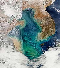
NASA image acquired August 17, 2010, the Northwest Passage almost free of ice. Original from NASA. Digitally enhanced by…![Images of the Earth's land surface and surrounding coastal regions. Original from NASA. Digitally enhanced by rawpixel.]() Images of the Earth's land surface and surrounding coastal regions. Original from NASA. Digitally enhanced by rawpixel.
Images of the Earth's land surface and surrounding coastal regions. Original from NASA. Digitally enhanced by rawpixel.![Drawing on data from multiple satellite missions a team of NASA scientists and graphic artists created this globe and the…]() Drawing on data from multiple satellite missions a team of NASA scientists and graphic artists created this globe and the…
Drawing on data from multiple satellite missions a team of NASA scientists and graphic artists created this globe and the…![Japan poster template]() Japan poster template
Japan poster templateTrending Design
![Missionary Plains in Australia’s Northern Territory, a crater 24 kilometers in diameter and 5 kilometers deep.…]() Missionary Plains in Australia’s Northern Territory, a crater 24 kilometers in diameter and 5 kilometers deep.…
Missionary Plains in Australia’s Northern Territory, a crater 24 kilometers in diameter and 5 kilometers deep.…![Rare clear view of Alaska. Original from NASA. Digitally enhanced by rawpixel.]() Rare clear view of Alaska. Original from NASA. Digitally enhanced by rawpixel.
Rare clear view of Alaska. Original from NASA. Digitally enhanced by rawpixel.![Images of the Earth's land surface and surrounding coastal regions. Original from NASA. Digitally enhanced by rawpixel.]() Images of the Earth's land surface and surrounding coastal regions. Original from NASA. Digitally enhanced by rawpixel.
Images of the Earth's land surface and surrounding coastal regions. Original from NASA. Digitally enhanced by rawpixel.![An iceberg trapped in sea ice in the Amundsen Sea. Original from NASA. Digitally enhanced by rawpixel.]() An iceberg trapped in sea ice in the Amundsen Sea. Original from NASA. Digitally enhanced by rawpixel.
An iceberg trapped in sea ice in the Amundsen Sea. Original from NASA. Digitally enhanced by rawpixel.![The U.S. Coast Guard Cutter Healy encountered only small patches of sea ice in the Chukchi Sea during the final days…]() The U.S. Coast Guard Cutter Healy encountered only small patches of sea ice in the Chukchi Sea during the final days…
The U.S. Coast Guard Cutter Healy encountered only small patches of sea ice in the Chukchi Sea during the final days…![Phytoplankton bloom off Newfoundland. Original from NASA. Digitally enhanced by rawpixel.]() Phytoplankton bloom off Newfoundland. Original from NASA. Digitally enhanced by rawpixel.
Phytoplankton bloom off Newfoundland. Original from NASA. Digitally enhanced by rawpixel.![Phytoplankton bloom in the Bay of Biscay. Original from NASA. Digitally enhanced by rawpixel.]() Phytoplankton bloom in the Bay of Biscay. Original from NASA. Digitally enhanced by rawpixel.
Phytoplankton bloom in the Bay of Biscay. Original from NASA. Digitally enhanced by rawpixel.![Edge of an ice shelf in Adelaide Island, off the Antarctic Peninsula. Original from NASA. Digitally enhanced by rawpixel.]() Edge of an ice shelf in Adelaide Island, off the Antarctic Peninsula. Original from NASA. Digitally enhanced by rawpixel.
Edge of an ice shelf in Adelaide Island, off the Antarctic Peninsula. Original from NASA. Digitally enhanced by rawpixel.![The Matusevich Glacier flows toward the coast of East Antarctica, pushing through a channel between the Lazarev Mountains…]() The Matusevich Glacier flows toward the coast of East Antarctica, pushing through a channel between the Lazarev Mountains…
The Matusevich Glacier flows toward the coast of East Antarctica, pushing through a channel between the Lazarev Mountains…![Massive congregations of greenish phytoplankton swirl in the dark water around Gotland, a Swedish island in the Baltic Sea.…]() Massive congregations of greenish phytoplankton swirl in the dark water around Gotland, a Swedish island in the Baltic Sea.…
Massive congregations of greenish phytoplankton swirl in the dark water around Gotland, a Swedish island in the Baltic Sea.…![On July 20, the U.S. Coast Guard Cutter Healy steamed south in the Arctic Ocean toward the edge of the sea ice. Original…]() On July 20, the U.S. Coast Guard Cutter Healy steamed south in the Arctic Ocean toward the edge of the sea ice. Original…
On July 20, the U.S. Coast Guard Cutter Healy steamed south in the Arctic Ocean toward the edge of the sea ice. Original…![Arrival of the RRS Ernest Shackleton near Halley Research Station in Antarctica, January, 2013. Original from NASA.…]() Arrival of the RRS Ernest Shackleton near Halley Research Station in Antarctica, January, 2013. Original from NASA.…
Arrival of the RRS Ernest Shackleton near Halley Research Station in Antarctica, January, 2013. Original from NASA.…![View of the northern Antarctic Peninsula from high altitude during IceBridge's flight back from the Foundation Ice Stream…]() View of the northern Antarctic Peninsula from high altitude during IceBridge's flight back from the Foundation Ice Stream…
View of the northern Antarctic Peninsula from high altitude during IceBridge's flight back from the Foundation Ice Stream…![Ice on the Ellsworth Range in Antarctica as seen from the IceBridge DC-8 on Oct. 22, 2012. Original from NASA. Digitally…]() Ice on the Ellsworth Range in Antarctica as seen from the IceBridge DC-8 on Oct. 22, 2012. Original from NASA. Digitally…
Ice on the Ellsworth Range in Antarctica as seen from the IceBridge DC-8 on Oct. 22, 2012. Original from NASA. Digitally…![These rocks are famous because they move, leaving tell-tale trails in the clay, like this one. Original from NASA. Digitally…]() These rocks are famous because they move, leaving tell-tale trails in the clay, like this one. Original from NASA. Digitally…
These rocks are famous because they move, leaving tell-tale trails in the clay, like this one. Original from NASA. Digitally…![Image of the sun while spewing streams of particles for over two days (Aug. 17-19, 2015) before breaking apart. Original…]() Image of the sun while spewing streams of particles for over two days (Aug. 17-19, 2015) before breaking apart. Original…
Image of the sun while spewing streams of particles for over two days (Aug. 17-19, 2015) before breaking apart. Original…![Earth observations taken from Space Shuttle Columbia during STS-93 mission. Original from NASA. Digitally enhanced by…]() Earth observations taken from Space Shuttle Columbia during STS-93 mission. Original from NASA. Digitally enhanced by…
Earth observations taken from Space Shuttle Columbia during STS-93 mission. Original from NASA. Digitally enhanced by…![Heilongjiang, a province of China located in the northeastern part of the country. Original from NASA. Digitally enhanced by…]() Heilongjiang, a province of China located in the northeastern part of the country. Original from NASA. Digitally enhanced by…
Heilongjiang, a province of China located in the northeastern part of the country. Original from NASA. Digitally enhanced by…![This image from NASA's Terra spacecraft shows Beihai, a city in the south of Guangxi, People's republic of China. Original…]() This image from NASA's Terra spacecraft shows Beihai, a city in the south of Guangxi, People's republic of China. Original…
This image from NASA's Terra spacecraft shows Beihai, a city in the south of Guangxi, People's republic of China. Original…![Moon crossing in front of its view of the sun captured by NASA’s Solar Dynamics Observatory (SDO) on Jan 30th, 2014.…]() Moon crossing in front of its view of the sun captured by NASA’s Solar Dynamics Observatory (SDO) on Jan 30th, 2014.…
Moon crossing in front of its view of the sun captured by NASA’s Solar Dynamics Observatory (SDO) on Jan 30th, 2014.…![Akpatok Island in Ungava Bay in northern Quebec, Canada. Original from NASA. Digitally enhanced by rawpixel.]() Akpatok Island in Ungava Bay in northern Quebec, Canada. Original from NASA. Digitally enhanced by rawpixel.
Akpatok Island in Ungava Bay in northern Quebec, Canada. Original from NASA. Digitally enhanced by rawpixel.![GOES 11 satellite image showing earth on March 25, 2010. Original from NASA. Digitally enhanced by rawpixel.]() GOES 11 satellite image showing earth on March 25, 2010. Original from NASA. Digitally enhanced by rawpixel.
GOES 11 satellite image showing earth on March 25, 2010. Original from NASA. Digitally enhanced by rawpixel.![NASA GOES 12 satellite image showing earth on March 30, 2010. Original from NASA. Digitally enhanced by rawpixel.]() NASA GOES 12 satellite image showing earth on March 30, 2010. Original from NASA. Digitally enhanced by rawpixel.
NASA GOES 12 satellite image showing earth on March 30, 2010. Original from NASA. Digitally enhanced by rawpixel.![GOES 12 satellite image showing earth on March 25, 2010. Original from NASA . Digitally enhanced by rawpixel.]() GOES 12 satellite image showing earth on March 25, 2010. Original from NASA . Digitally enhanced by rawpixel.
GOES 12 satellite image showing earth on March 25, 2010. Original from NASA . Digitally enhanced by rawpixel.![Guangxi Province in southeast China. Original from NASA. Digitally enhanced by rawpixel.]() Guangxi Province in southeast China. Original from NASA. Digitally enhanced by rawpixel.
Guangxi Province in southeast China. Original from NASA. Digitally enhanced by rawpixel.![Ireland on the first day this summer. Original from NASA. Digitally enhanced by rawpixel.]() Ireland on the first day this summer. Original from NASA. Digitally enhanced by rawpixel.
Ireland on the first day this summer. Original from NASA. Digitally enhanced by rawpixel.![Ribbons of Saharan sand dunes seem to glow in sunset colors. Original from NASA. Digitally enhanced by rawpixel.]() Ribbons of Saharan sand dunes seem to glow in sunset colors. Original from NASA. Digitally enhanced by rawpixel.
Ribbons of Saharan sand dunes seem to glow in sunset colors. Original from NASA. Digitally enhanced by rawpixel.![The giant elliptical galaxy NGC 5128, show here in visible light, hosts the radio source known as Centaurus A. Released on…]() The giant elliptical galaxy NGC 5128, show here in visible light, hosts the radio source known as Centaurus A. Released on…
The giant elliptical galaxy NGC 5128, show here in visible light, hosts the radio source known as Centaurus A. Released on…![The Earth created by various layers of satellite footage. Original from NASA. Digitally enhanced by rawpixel.]() The Earth created by various layers of satellite footage. Original from NASA. Digitally enhanced by rawpixel.
The Earth created by various layers of satellite footage. Original from NASA. Digitally enhanced by rawpixel.![Cloud vortices off Madeira and Canary Islands. Original from NASA. Digitally enhanced by rawpixel.]() Cloud vortices off Madeira and Canary Islands. Original from NASA. Digitally enhanced by rawpixel.
Cloud vortices off Madeira and Canary Islands. Original from NASA. Digitally enhanced by rawpixel.![Hurricane Gonzalo's northern quadrant over Bermuda. Original from NASA. Digitally enhanced by rawpixel.]() Hurricane Gonzalo's northern quadrant over Bermuda. Original from NASA. Digitally enhanced by rawpixel.
Hurricane Gonzalo's northern quadrant over Bermuda. Original from NASA. Digitally enhanced by rawpixel.![NASA Blue Marble 2007 West captured by the Moderate Resolution Imaging Spectroradiometer on NASA’s Terra satellite in…]() NASA Blue Marble 2007 West captured by the Moderate Resolution Imaging Spectroradiometer on NASA’s Terra satellite in…
NASA Blue Marble 2007 West captured by the Moderate Resolution Imaging Spectroradiometer on NASA’s Terra satellite in…![This is a composite image of NGC 1068, one of the nearest and brightest galaxies containing a rapidly growing supermassive…]() This is a composite image of NGC 1068, one of the nearest and brightest galaxies containing a rapidly growing supermassive…
This is a composite image of NGC 1068, one of the nearest and brightest galaxies containing a rapidly growing supermassive…![NASA and NOAA satellites are studying the triple tropical tempests that are now romping through the Eastern Pacific Ocean.…]() NASA and NOAA satellites are studying the triple tropical tempests that are now romping through the Eastern Pacific Ocean.…
NASA and NOAA satellites are studying the triple tropical tempests that are now romping through the Eastern Pacific Ocean.…![MODIS on the Aqua satellite captured this stunning view of Japans four largest islands on February 20, 2004. Original from…]() MODIS on the Aqua satellite captured this stunning view of Japans four largest islands on February 20, 2004. Original from…
MODIS on the Aqua satellite captured this stunning view of Japans four largest islands on February 20, 2004. Original from…![GOES 12 satellite image showing earth on March 25, 2010. Original from NASA. Digitally enhanced by rawpixel.]() GOES 12 satellite image showing earth on March 25, 2010. Original from NASA. Digitally enhanced by rawpixel.
GOES 12 satellite image showing earth on March 25, 2010. Original from NASA. Digitally enhanced by rawpixel.![Open-cell and closed-cell clouds off Peru. Original from NASA. Digitally enhanced by rawpixel.]() Open-cell and closed-cell clouds off Peru. Original from NASA. Digitally enhanced by rawpixel.
Open-cell and closed-cell clouds off Peru. Original from NASA. Digitally enhanced by rawpixel.![Open-cell and closed-cell clouds off Peru. Original from NASA. Digitally enhanced by rawpixel.]() Open-cell and closed-cell clouds off Peru. Original from NASA. Digitally enhanced by rawpixel.
Open-cell and closed-cell clouds off Peru. Original from NASA. Digitally enhanced by rawpixel.![Thailand floods monitored by a NASA satellite. Original from NASA. Digitally enhanced by rawpixel.]() Thailand floods monitored by a NASA satellite. Original from NASA. Digitally enhanced by rawpixel.
Thailand floods monitored by a NASA satellite. Original from NASA. Digitally enhanced by rawpixel.![GOES 11 satellite image showing earth on March 25, 2010. Original from NASA. Digitally enhanced by rawpixel.]() GOES 11 satellite image showing earth on March 25, 2010. Original from NASA. Digitally enhanced by rawpixel.
GOES 11 satellite image showing earth on March 25, 2010. Original from NASA. Digitally enhanced by rawpixel.![Wave Clouds over Ireland. Original from NASA. Digitally enhanced by rawpixel.]() Wave Clouds over Ireland. Original from NASA. Digitally enhanced by rawpixel.
Wave Clouds over Ireland. Original from NASA. Digitally enhanced by rawpixel.![On Aug. 31, 2012, a giant prominence on the sun erupted, sending out particles and a shock wave that traveled near Earth.…]() On Aug. 31, 2012, a giant prominence on the sun erupted, sending out particles and a shock wave that traveled near Earth.…
On Aug. 31, 2012, a giant prominence on the sun erupted, sending out particles and a shock wave that traveled near Earth.…![Snow-capped peaks and ridges of the eastern Himalaya Mountains. Original from NASA. Digitally enhanced by rawpixel.]() Snow-capped peaks and ridges of the eastern Himalaya Mountains. Original from NASA. Digitally enhanced by rawpixel.
Snow-capped peaks and ridges of the eastern Himalaya Mountains. Original from NASA. Digitally enhanced by rawpixel.![Great Ball of Fire - Activity from August 1 CME Subsides. Original from NASA. Digitally enhanced by rawpixel.]() Great Ball of Fire - Activity from August 1 CME Subsides. Original from NASA. Digitally enhanced by rawpixel.
Great Ball of Fire - Activity from August 1 CME Subsides. Original from NASA. Digitally enhanced by rawpixel.![Full moon over lava lake in Hawaii Volcanoes National Park .Original from NASA. Digitally enhanced by rawpixel.]() Full moon over lava lake in Hawaii Volcanoes National Park .Original from NASA. Digitally enhanced by rawpixel.
Full moon over lava lake in Hawaii Volcanoes National Park .Original from NASA. Digitally enhanced by rawpixel.![This image from NASA's EarthKAM captures almost all of Quinghai, the largest lake in China. Original from NASA. Digitally…]() This image from NASA's EarthKAM captures almost all of Quinghai, the largest lake in China. Original from NASA. Digitally…
This image from NASA's EarthKAM captures almost all of Quinghai, the largest lake in China. Original from NASA. Digitally…![ICESCAPE scientists watched from the deck of the Healy as it cut a path through thick multiyear ice on July 6, 2011.…]() ICESCAPE scientists watched from the deck of the Healy as it cut a path through thick multiyear ice on July 6, 2011.…
ICESCAPE scientists watched from the deck of the Healy as it cut a path through thick multiyear ice on July 6, 2011.…![The Lena River, some 2,800 miles long, is one of the largest rivers in the world. Original from NASA. Digitally enhanced by…]() The Lena River, some 2,800 miles long, is one of the largest rivers in the world. Original from NASA. Digitally enhanced by…
The Lena River, some 2,800 miles long, is one of the largest rivers in the world. Original from NASA. Digitally enhanced by…![A colony of Magellanic penguins near Punta Arenas, Chile. Original from NASA. Digitally enhanced by rawpixel.]() A colony of Magellanic penguins near Punta Arenas, Chile. Original from NASA. Digitally enhanced by rawpixel.
A colony of Magellanic penguins near Punta Arenas, Chile. Original from NASA. Digitally enhanced by rawpixel.![Earth Observation taken during the 41G mission on October 5-13, 2016. Original from NASA. Digitally enhanced by rawpixel.]() Earth Observation taken during the 41G mission on October 5-13, 2016. Original from NASA. Digitally enhanced by rawpixel.
Earth Observation taken during the 41G mission on October 5-13, 2016. Original from NASA. Digitally enhanced by rawpixel.![NASA satellite tracks underwater volcanic eruption in Canary Islands. Original from NASA. Digitally enhanced by rawpixel.]() NASA satellite tracks underwater volcanic eruption in Canary Islands. Original from NASA. Digitally enhanced by rawpixel.
NASA satellite tracks underwater volcanic eruption in Canary Islands. Original from NASA. Digitally enhanced by rawpixel.![Guinea-Bissau, a small country in West Africa. Original from NASA. Digitally enhanced by rawpixel.]() Guinea-Bissau, a small country in West Africa. Original from NASA. Digitally enhanced by rawpixel.
Guinea-Bissau, a small country in West Africa. Original from NASA. Digitally enhanced by rawpixel.![The Webb Telescope's 'Golden Spider'. Original from NASA. Digitally enhanced by rawpixel.]() The Webb Telescope's 'Golden Spider'. Original from NASA. Digitally enhanced by rawpixel.
The Webb Telescope's 'Golden Spider'. Original from NASA. Digitally enhanced by rawpixel.![Climate change poster template]() Climate change poster template
Climate change poster template![Climate change quote Facebook story]() Climate change quote Facebook story
Climate change quote Facebook story![The flooding from the Chao Phraya River, Thailand on Nov. 17, 2011. Original from NASA. Digitally enhanced by rawpixel.]() The flooding from the Chao Phraya River, Thailand on Nov. 17, 2011. Original from NASA. Digitally enhanced by rawpixel.
The flooding from the Chao Phraya River, Thailand on Nov. 17, 2011. Original from NASA. Digitally enhanced by rawpixel.![Flooding from the Chao Phraya River, Thailand on Nov. 1, 2011. Original from NASA. Digitally enhanced by rawpixel.]() Flooding from the Chao Phraya River, Thailand on Nov. 1, 2011. Original from NASA. Digitally enhanced by rawpixel.
Flooding from the Chao Phraya River, Thailand on Nov. 1, 2011. Original from NASA. Digitally enhanced by rawpixel.![The U.S. Coast Guard Cutter Healy parked in an ice floe for the 2011 ICESCAPE mission's third ice station in the Chukchi…]() The U.S. Coast Guard Cutter Healy parked in an ice floe for the 2011 ICESCAPE mission's third ice station in the Chukchi…
The U.S. Coast Guard Cutter Healy parked in an ice floe for the 2011 ICESCAPE mission's third ice station in the Chukchi…![The Channel Tunnel, a 50.5 km-long rail tunnel beneath the English Channel at the Straits of Dover. Original from NASA.…]() The Channel Tunnel, a 50.5 km-long rail tunnel beneath the English Channel at the Straits of Dover. Original from NASA.…
The Channel Tunnel, a 50.5 km-long rail tunnel beneath the English Channel at the Straits of Dover. Original from NASA.…![Rio Gurupi in the Brazilian state of Maranhao and its delta.Original from NASA. Digitally enhanced by rawpixel.]() Rio Gurupi in the Brazilian state of Maranhao and its delta.Original from NASA. Digitally enhanced by rawpixel.
Rio Gurupi in the Brazilian state of Maranhao and its delta.Original from NASA. Digitally enhanced by rawpixel.![Saunders Island and Wolstenholme Fjord with Kap Atholl in the background. Original from NASA. Digitally enhanced by rawpixel.]() Saunders Island and Wolstenholme Fjord with Kap Atholl in the background. Original from NASA. Digitally enhanced by rawpixel.
Saunders Island and Wolstenholme Fjord with Kap Atholl in the background. Original from NASA. Digitally enhanced by rawpixel.![Climate change quote poster]() Climate change quote poster
Climate change quote poster ![Lying in the eastern Mediterranean Sea, the entire Island of Crete (35.0N, 25.0E) can be seen in great detail in this cloud…]() Lying in the eastern Mediterranean Sea, the entire Island of Crete (35.0N, 25.0E) can be seen in great detail in this cloud…
Lying in the eastern Mediterranean Sea, the entire Island of Crete (35.0N, 25.0E) can be seen in great detail in this cloud…![The terrain for the scientific work conducted by ICESCAPE scientists on July 4, 2010. Original from NASA. Digitally enhanced…]() The terrain for the scientific work conducted by ICESCAPE scientists on July 4, 2010. Original from NASA. Digitally enhanced…
The terrain for the scientific work conducted by ICESCAPE scientists on July 4, 2010. Original from NASA. Digitally enhanced…![The ice of a piedmont glacier spills from a steep valley onto a relatively flat plain. Malaspina Glacier, Alaska. Original…]() The ice of a piedmont glacier spills from a steep valley onto a relatively flat plain. Malaspina Glacier, Alaska. Original…
The ice of a piedmont glacier spills from a steep valley onto a relatively flat plain. Malaspina Glacier, Alaska. Original…![The STS-93 astronauts aboard the Space Shuttle Columbia took this picture over the Indian Ocean on 23-27 July 1999. Original…]() The STS-93 astronauts aboard the Space Shuttle Columbia took this picture over the Indian Ocean on 23-27 July 1999. Original…
The STS-93 astronauts aboard the Space Shuttle Columbia took this picture over the Indian Ocean on 23-27 July 1999. Original…![Greens and blues of the ocean color from NASA satellite data. Original from NASA. Digitally enhanced by rawpixel.]() Greens and blues of the ocean color from NASA satellite data. Original from NASA. Digitally enhanced by rawpixel.
Greens and blues of the ocean color from NASA satellite data. Original from NASA. Digitally enhanced by rawpixel.![Longyearbyen, the largest island of the Svalbard archipelago, part of the Kingdom of Norway. Original from NASA. Digitally…]() Longyearbyen, the largest island of the Svalbard archipelago, part of the Kingdom of Norway. Original from NASA. Digitally…
Longyearbyen, the largest island of the Svalbard archipelago, part of the Kingdom of Norway. Original from NASA. Digitally…![Rostov-on-Don, a Russian City on the Don River, 32 kilometers from the Sea of Azov. Original from NASA. Digitally enhanced…]() Rostov-on-Don, a Russian City on the Don River, 32 kilometers from the Sea of Azov. Original from NASA. Digitally enhanced…
Rostov-on-Don, a Russian City on the Don River, 32 kilometers from the Sea of Azov. Original from NASA. Digitally enhanced…![Earth's shadow blocking the sun light captured by NASA on April 3rd, 2011. Original from NASA. Digitally enhanced by…]() Earth's shadow blocking the sun light captured by NASA on April 3rd, 2011. Original from NASA. Digitally enhanced by…
Earth's shadow blocking the sun light captured by NASA on April 3rd, 2011. Original from NASA. Digitally enhanced by…![Sakhalin Island, located just north of Japan and east of the Khabarovski and Primorski Krai of the Russian Far East.…]() Sakhalin Island, located just north of Japan and east of the Khabarovski and Primorski Krai of the Russian Far East.…
Sakhalin Island, located just north of Japan and east of the Khabarovski and Primorski Krai of the Russian Far East.…![Nearly cloud-free view of Great Britain and Ireland was acquired by the Moderate Resolution Imaging Spectroradiometer aboard…]() Nearly cloud-free view of Great Britain and Ireland was acquired by the Moderate Resolution Imaging Spectroradiometer aboard…
Nearly cloud-free view of Great Britain and Ireland was acquired by the Moderate Resolution Imaging Spectroradiometer aboard…![An iceberg embedded in sea ice as seen from the IceBridge DC-8 over the Bellingshausen Sea on Oct. 19, 2012. Original from…]() An iceberg embedded in sea ice as seen from the IceBridge DC-8 over the Bellingshausen Sea on Oct. 19, 2012. Original from…
An iceberg embedded in sea ice as seen from the IceBridge DC-8 over the Bellingshausen Sea on Oct. 19, 2012. Original from…![James Webb Space Telescope Mirror Halfway Complete. Inside NASA's Goddard Space Flight Center's massive clean room in…]() James Webb Space Telescope Mirror Halfway Complete. Inside NASA's Goddard Space Flight Center's massive clean room in…
James Webb Space Telescope Mirror Halfway Complete. Inside NASA's Goddard Space Flight Center's massive clean room in…![This rare cloud-free view of southern Italy shows almost all of the famous `boot' configuration of the peninsula up to just…]() This rare cloud-free view of southern Italy shows almost all of the famous `boot' configuration of the peninsula up to just…
This rare cloud-free view of southern Italy shows almost all of the famous `boot' configuration of the peninsula up to just…![Parts of he Kimberley region of Western Australia. Original from NASA. Digitally enhanced by rawpixel.]() Parts of he Kimberley region of Western Australia. Original from NASA. Digitally enhanced by rawpixel.
Parts of he Kimberley region of Western Australia. Original from NASA. Digitally enhanced by rawpixel.![Isles of Scilly, United Kingdom. Original from NASA. Digitally enhanced by rawpixel.]() Isles of Scilly, United Kingdom. Original from NASA. Digitally enhanced by rawpixel.
Isles of Scilly, United Kingdom. Original from NASA. Digitally enhanced by rawpixel.![View of portion of Queensland, Australia from Skylab space station. Original from NASA. Digitally enhanced by rawpixel]() View of portion of Queensland, Australia from Skylab space station. Original from NASA. Digitally enhanced by rawpixel
View of portion of Queensland, Australia from Skylab space station. Original from NASA. Digitally enhanced by rawpixel![View of the USSR, Siberia area from Skylab 4. Other areas seen are Ozero, Kanka, Ussiriysk, the Sea of Japan and Kavalerovo.…]() View of the USSR, Siberia area from Skylab 4. Other areas seen are Ozero, Kanka, Ussiriysk, the Sea of Japan and Kavalerovo.…
View of the USSR, Siberia area from Skylab 4. Other areas seen are Ozero, Kanka, Ussiriysk, the Sea of Japan and Kavalerovo.…![Skylab 3 Earth view of the Nile Delta, Egypt and Suez Canal. Original from NASA. Digitally enhanced by rawpixel.]() Skylab 3 Earth view of the Nile Delta, Egypt and Suez Canal. Original from NASA. Digitally enhanced by rawpixel.
Skylab 3 Earth view of the Nile Delta, Egypt and Suez Canal. Original from NASA. Digitally enhanced by rawpixel.![View of the Arctic waters and the far northern lands surrounding it. Original from NASA. Digitally enhanced by rawpixel.]() View of the Arctic waters and the far northern lands surrounding it. Original from NASA. Digitally enhanced by rawpixel.
View of the Arctic waters and the far northern lands surrounding it. Original from NASA. Digitally enhanced by rawpixel.![Earth observation by the crew of the International Space Station. Original from NASA. Digitally enhanced by rawpixel.]() Earth observation by the crew of the International Space Station. Original from NASA. Digitally enhanced by rawpixel.
Earth observation by the crew of the International Space Station. Original from NASA. Digitally enhanced by rawpixel.![Eruption of Cleveland Volcano, Aleutian Islands, Alaska. Original from NASA. Digitally enhanced by rawpixel.]() Eruption of Cleveland Volcano, Aleutian Islands, Alaska. Original from NASA. Digitally enhanced by rawpixel.
Eruption of Cleveland Volcano, Aleutian Islands, Alaska. Original from NASA. Digitally enhanced by rawpixel.![The Musandam Peninsula, part of Oman. Original from NASA. Digitally enhanced by rawpixel.]() The Musandam Peninsula, part of Oman. Original from NASA. Digitally enhanced by rawpixel.
The Musandam Peninsula, part of Oman. Original from NASA. Digitally enhanced by rawpixel.![Aaland archipelago at the mouth of the Gulf of Bothnia which belongs to Finland. Original from NASA. Digitally enhanced by…]() Aaland archipelago at the mouth of the Gulf of Bothnia which belongs to Finland. Original from NASA. Digitally enhanced by…
Aaland archipelago at the mouth of the Gulf of Bothnia which belongs to Finland. Original from NASA. Digitally enhanced by…