Teshekpuk Lake on Alaska's North Slope, within the National Petroleum Reserve. Original from NASA. Digitally enhanced by… https://www.rawpixel.com/image/441144/free-photo-image-science-alaska-world-map Free Image from public domain license
Image showing the west coast of Greenland, one of Earth's premiere incubators for icebergs. Original from NASA. Digitally… https://www.rawpixel.com/image/441795/free-photo-image-aerial-view-maps Free Image from public domain license
Attu, the westernmost Aleutian island, is nearly 1760 km from the Alaskan mainland. Original from NASA. Digitally enhanced… https://www.rawpixel.com/image/441125/free-photo-image-nasa-map-space-earth Free Image from public domain license
Ellesmere Island, which is part of the Qikiqtaaluk Region of the Canadian territory of Nunavut. Original from NASA.… https://www.rawpixel.com/image/440667/free-photo-image-maps-nasa-earth-map Free Image from public domain license
Santo Domingo, the capital of the Dominican Republic. Original from NASA. Digitally enhanced by rawpixel. https://www.rawpixel.com/image/440567/free-photo-image-dominican-republic-christopher-columbus Free Image from public domain license
The Musandam Peninsula, part of Oman. Original from NASA. Digitally enhanced by rawpixel. https://www.rawpixel.com/image/441188/free-photo-image-map-nasa-earth-landscape Free Image from public domain license
Brasilia, the capital of Brazil. Original from NASA. Digitally enhanced by rawpixel. https://www.rawpixel.com/image/441221/free-photo-image-brazil-brasilia-city-map Free Image from public domain license
Aaland archipelago at the mouth of the Gulf of Bothnia which belongs to Finland. Original from NASA. Digitally enhanced by… https://www.rawpixel.com/image/441242/free-photo-image-nasa-nasa-earth-helsinki Free Image from public domain license
Thailand floods monitored by a NASA satellite. Original from NASA. Digitally enhanced by rawpixel. https://www.rawpixel.com/image/441275/free-photo-image-nasa-map-river-bank Free Image from public domain license
Image from NASA's Terra spacecraft of Franz Josef Land, an archipelago in the far north of Russia. Original from NASA.… https://www.rawpixel.com/image/441324/free-photo-image-maps-nasa-russia Free Image from public domain license
NASA satellite tracks underwater volcanic eruption in Canary Islands. Original from NASA. Digitally enhanced by rawpixel. https://www.rawpixel.com/image/441274/free-photo-image-ocean-underwater-climate-change Free Image from public domain license
Heilongjiang, a province of China located in the northeastern part of the country. Original from NASA. Digitally enhanced by… https://www.rawpixel.com/image/440587/heilongjiang-province-space-view Free Image from public domain license
The Channel Tunnel, a 50.5 km-long rail tunnel beneath the English Channel at the Straits of Dover. Original from NASA.… https://www.rawpixel.com/image/441134/channel-tunnel-space-view Free Image from public domain license
Grand Turk Island is an island in the Turks and Caicos Islands in the Caribbean, and contains the territory's capital… https://www.rawpixel.com/image/441237/free-photo-image-nasa-2001-maps Free Image from public domain license
Jamestown, located on Jamestown Island in the Virginia Colony. Original from NASA. Digitally enhanced by rawpixel. https://www.rawpixel.com/image/441199/jamestown-space-view Free Image from public domain license
This image from NASA's Terra spacecraft shows Beihai, a city in the south of Guangxi, People's republic of China. Original… https://www.rawpixel.com/image/440652/free-photo-image-map-nasa-china Free Image from public domain license
The northernmost land in the world is located in Pearyland, Greenland. Original from NASA. Digitally enhanced by rawpixel. https://www.rawpixel.com/image/441198/free-photo-image-nasa-snow-greenland-nature Free Image from public domain license
Eruption of Cleveland Volcano, Aleutian Islands, Alaska. Original from NASA. Digitally enhanced by rawpixel. https://www.rawpixel.com/image/440821/free-photo-image-volcano-maps-nasa Free Image from public domain license
The Wilkins Ice Shelf on the western side of the Antarctic Peninsula. Original from NASA. Digitally enhanced by rawpixel. https://www.rawpixel.com/image/441236/free-photo-image-maps-snow-advanced-spaceborne-thermal-emission-and-reflection-radiometer-aster Free Image from public domain license
Torrential rains in the mid-South of the United States in mid-March 2016 produced flooding throughout Texas, Louisiana and… https://www.rawpixel.com/image/440664/free-photo-image-nasa-louisiana-space Free Image from public domain license
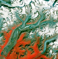
The ice of a piedmont glacier spills from a steep valley onto a relatively flat plain. Malaspina Glacier, Alaska. Original… https://www.rawpixel.com/image/440088/free-photo-image-nasa-map-piedmont Free Image from public domain license
Al Jazirah (also Gezira) is one of the 26 states of Sudan. Original from NASA. Digitally enhanced by rawpixel. https://www.rawpixel.com/image/441167/free-photo-image-map-nasa-blue Free Image from public domain license
Simulated natural color image of Huron, South Dakota, captured by NASA's Terra spacecraft. Original from NASA. Digitally… https://www.rawpixel.com/image/441231/free-photo-image-south-dakota-satellite-aerial Free Image from public domain license
Rare clear view of Alaska. Original from NASA. Digitally enhanced by rawpixel. https://www.rawpixel.com/image/440179/free-photo-image-coastline-forest-maps Free Image from public domain license
This image from NASA's Terra spacecraft shows the Kuk Early Agricultural Site in the western highlands of New Guinea.… https://www.rawpixel.com/image/441178/free-photo-image-swamp-nasa-climate-change Free Image from public domain license
The Arctic Circle cuts through the western coast of Norway and the Saltfjellet-Svartisen National Park. Original from NASA.… https://www.rawpixel.com/image/441172/free-photo-image-nasa-climate-change-aerial Free Image from public domain license
Longyearbyen, the largest island of the Svalbard archipelago, part of the Kingdom of Norway. Original from NASA. Digitally… https://www.rawpixel.com/image/439954/free-photo-image-nasa-norway-mountains-world-map Free Image from public domain license
The Uvs Nuur Basin in Mongolia and the Russian Federation. Original from NASA. Digitally enhanced by rawpixel. https://www.rawpixel.com/image/439971/free-photo-image-nasa-maps-earth-observations Free Image from public domain license
Lake Naivasha, 90km north-west of Nairobi. Original from NASA. Digitally enhanced by rawpixel. https://www.rawpixel.com/image/441152/free-photo-image-kenya-nasa-lake-satellite-landscape Free Image from public domain license
Nuuk (or Gadthab) is the capital and largest city of Greenland. Original from NASA. Digitally enhanced by rawpixel https://www.rawpixel.com/image/441177/free-photo-image-space-earth-aerial-view Free Image from public domain license
The Kondyor Massif is located in Eastern Siberia, Russia, north of the city of Khabarovsk. Original from NASA. Digitally… https://www.rawpixel.com/image/441148/free-photo-image-map-nasa-russia Free Image from public domain license
Rostov-on-Don, a Russian City on the Don River, 32 kilometers from the Sea of Azov. Original from NASA. Digitally enhanced… https://www.rawpixel.com/image/440623/free-photo-image-nasa-map-world Free Image from public domain license
Lake Mackay, the largest of hundreds of ephemeral lakes scattered throughout Western Australia and the Northern Territory.… https://www.rawpixel.com/image/440591/free-photo-image-nasa-map-earth Free Image from public domain license
The Isthmus of Corinth has played a very important role in the history of Greece. Original from NASA. Digitally enhanced by… https://www.rawpixel.com/image/441129/free-photo-image-nasa-greece-maps Free Image from public domain license
Lake Ilopango, a crater lake which fills a volcanic caldera in central El Salvador. Original from NASA. Digitally enhanced… https://www.rawpixel.com/image/440647/free-photo-image-salvador-satellite-lake Free Image from public domain license
Aerial view of Berlin, acquired by NASA's Terra spacecraft. Original from NASA. Digitally enhanced by rawpixel. https://www.rawpixel.com/image/441098/free-photo-image-maps-berlin-nasa-stadium Free Image from public domain license
Sheveluch Volcano in Kamchatka, Siberia. Original from NASA. Digitally enhanced by rawpixel. https://www.rawpixel.com/image/441226/free-photo-image-map-volcano-nasa Free Image from public domain license
Delhi, the second largest metropolis in India, with a population of 16 million. Original from NASA. Digitally enhanced by… https://www.rawpixel.com/image/441145/free-photo-image-map-satellite-maps-public-domain-high-resolution-landscape Free Image from public domain license
Flood waters in Bangkok as the Ayutthaya River overflowed its banks. Original from NASA. Digitally enhanced by rawpixel. https://www.rawpixel.com/image/440502/free-photo-image-maps-background-flood Free Image from public domain license
On August 22, 2014 the Moderate Resolution Imaging Spectroradiometer aboard NASA’s Terra satellite captured a true… https://www.rawpixel.com/image/440172/free-photo-image-nasa-iceland-satellite Free Image from public domain license
Guangxi Province in southeast China. Original from NASA. Digitally enhanced by rawpixel. https://www.rawpixel.com/image/440654/guangxi-provine-space-view Free Image from public domain license
Flooding from the Chao Phraya River, Thailand on Nov. 1, 2011. Original from NASA. Digitally enhanced by rawpixel. https://www.rawpixel.com/image/440508/free-photo-image-nasa-map-thailand Free Image from public domain license
The flooding from the Chao Phraya River, Thailand on Nov. 17, 2011. Original from NASA. Digitally enhanced by rawpixel. https://www.rawpixel.com/image/440511/free-photo-image-nasa-background-2011 Free Image from public domain license
Image acquired by NASA's Terra spacecraft of the Sierra Leone estuary. Original from NASA. Digitally enhanced by rawpixel. https://www.rawpixel.com/image/418644/sierra-leone-estuary-space-view Free Image from public domain license
View of the Arctic waters and the far northern lands surrounding it. Original from NASA. Digitally enhanced by rawpixel. https://www.rawpixel.com/image/440114/free-photo-image-nasa-map-arctic-sea Free Image from public domain license
The Ouachita Mountains in southeast Oklahoma. Original from NASA. Digitally enhanced by rawpixel. https://www.rawpixel.com/image/441267/free-photo-image-nasa-map-oklahoma Free Image from public domain license
Hurricane Matthew. This is a visible image of Major Hurricane Matthew taken from NASA's Terra satellite on Oct. 7 at 12 p.m.… https://www.rawpixel.com/image/440032/free-photo-image-hurricane-disaster-map Free Image from public domain license
Phytoplankton bloom off Newfoundland. Original from NASA. Digitally enhanced by rawpixel. https://www.rawpixel.com/image/440201/phytoplankton-bloom-off-newfoundland Free Image from public domain license
The John F. Kennedy Space Center, America's spaceport, is located along Florida's eastern shore on Cape Canaveral. Original… https://www.rawpixel.com/image/441135/free-photo-image-florida-florida-maps-public-domain-map Free Image from public domain license
The Mackenzie River in the Northwest Territories, Canada. Original from NASA. Digitally enhanced by rawpixel. https://www.rawpixel.com/image/439973/map-green-terrain-canada Free Image from public domain license
Image formed by the Advanced Spaceborne Thermal Emission and Reflection Radiometer (ASTER) and Global Digital Elevation… https://www.rawpixel.com/image/441205/free-photo-image-world-map-digital Free Image from public domain license
New NASA laser technology reveals how ice measures up. Original from NASA. Digitally enhanced by rawpixel. https://www.rawpixel.com/image/440185/free-photo-image-greenland-snow-arctic-ocean Free Image from public domain license
Oslo, the capital and largest city in Norway. Original from NASA. Digitally enhanced by rawpixel. https://www.rawpixel.com/image/441269/free-photo-image-cc0-city-climate-change Free Image from public domain license
NASA's Terra spacecraft captured this image of the city of Arkhangelsk and administrative capital of Archangelsk Oblast… https://www.rawpixel.com/image/441238/free-photo-image-river-map-landscape Free Image from public domain license
Images of the Earth's land surface and surrounding coastal regions. Original from NASA. Digitally enhanced by rawpixel. https://www.rawpixel.com/image/440126/free-photo-image-map-coastal-nasa Free Image from public domain license
Plankton blooms in the Falkland Current east of the Argentinian coast. Original from NASA. Digitally enhanced by rawpixel. https://www.rawpixel.com/image/441573/free-photo-image-plankton-satellite-maps Free Image from public domain license
The city of Sukkur, Pakistan. Original from NASA. Digitally enhanced by rawpixel. https://www.rawpixel.com/image/441254/free-photo-image-flood-maps-august-2010 Free Image from public domain license
The meandering Ohio River bisecting this image is the border between Kentucky and Indiana. Original from NASA. Digitally… https://www.rawpixel.com/image/441771/free-photo-image-city-map-border-maps Free Image from public domain license
View of the Salt Lake City, Utah area. Original from NASA. Digitally enhanced by rawpixel. https://www.rawpixel.com/image/441792/free-photo-image-map-nasa-utah Free Image from public domain license
Apollo 9 Mission image - S0-65 Multispectral Photography - New Mexico. Original from NASA. Digitally enhanced by rawpixel. https://www.rawpixel.com/image/440775/free-photo-image-lava-mexico-maps Free Image from public domain license
Every southern spring and summer, after the Sun has risen into its 24-hour circuit around the skies of Antarctica, the Ross… https://www.rawpixel.com/image/440193/free-photo-image-maps-nasa-water Free Image from public domain license
Phytoplankton bloom in the Bay of Biscay. Original from NASA. Digitally enhanced by rawpixel. https://www.rawpixel.com/image/440161/free-photo-image-map-satellite-nasa Free Image from public domain license
Lying in the eastern Mediterranean Sea, the entire Island of Crete (35.0N, 25.0E) can be seen in great detail in this cloud… https://www.rawpixel.com/image/441790/free-photo-image-crete-greece-mediterranean Free Image from public domain license
Arabian Peninsula and northeast Africa as seen from the orbiting Gemini-11. Original from NASA. Digitally enhanced by… https://www.rawpixel.com/image/441740/free-photo-image-africa-map-space-view Free Image from public domain license
View of portion of Queensland, Australia from Skylab space station. Original from NASA. Digitally enhanced by rawpixel https://www.rawpixel.com/image/441793/free-photo-image-australia-map-skylab Free Image from public domain license
View of the USSR, Siberia area from Skylab 4. Other areas seen are Ozero, Kanka, Ussiriysk, the Sea of Japan and Kavalerovo.… https://www.rawpixel.com/image/441773/free-photo-image-siberia-japan-maps Free Image from public domain license
NASA’s Operation IceBridge Completes Twin Polar Campaigns. Heimdal Glacier in southern Greenland. Original from NASA.… https://www.rawpixel.com/image/440099/heimdal-glacier-southern-greenland Free Image from public domain license
NASA scientists are flying over Alaska and Canada, measuring the elevation of rivers and lakes. Original from NASA.… https://www.rawpixel.com/image/440080/river-drone-shot Free Image from public domain license
The terrain for the scientific work conducted by ICESCAPE scientists on July 4, 2010. Original from NASA. Digitally enhanced… https://www.rawpixel.com/image/440648/ice-sheet Free Image from public domain license
A NASA scientific balloon awaits launch in McMurdo, Antarctica. Original from NASA. Digitally enhanced by rawpixel. https://www.rawpixel.com/image/440208/free-photo-image-glacier-nasa-campaign Free Image from public domain license
Missionary Plains in Australia’s Northern Territory, a crater 24 kilometers in diameter and 5 kilometers deep.… https://www.rawpixel.com/image/440278/free-photo-image-nasa-australia-landscape Free Image from public domain license
The Matusevich Glacier flows toward the coast of East Antarctica, pushing through a channel between the Lazarev Mountains… https://www.rawpixel.com/image/440265/free-photo-image-climate-change-aerial-photography-nasa Free Image from public domain license
In this mostly cloud-free true-color scene, much of Scandinavia can be seen to be still covered by snow. Original from NASA.… https://www.rawpixel.com/image/440159/free-photo-image-scandinavia-norway-world-map Free Image from public domain license
An iceberg trapped in sea ice in the Amundsen Sea. Original from NASA. Digitally enhanced by rawpixel. https://www.rawpixel.com/image/440148/free-photo-image-iceberg-glacier-glacial Free Image from public domain license
The U.S. Coast Guard Cutter Healy encountered only small patches of sea ice in the Chukchi Sea during the final days… https://www.rawpixel.com/image/440168/free-photo-image-nasa-water-pollution Free Image from public domain license
Early Melt on the Greenland Ice Sheet . Original from NASA . Digitally enhanced by rawpixel. https://www.rawpixel.com/image/440064/free-photo-image-ice-iceberg-nasa Free Image from public domain license
View of Minneapolis-St.Paul, Minnesota area. Original from NASA. Digitally enhanced by rawpixel. https://www.rawpixel.com/image/441781/free-photo-image-nasa-minnesota-topography Free Image from public domain license
This rare cloud-free view of southern Italy shows almost all of the famous `boot' configuration of the peninsula up to just… https://www.rawpixel.com/image/441789/free-photo-image-southern-italy-nasa-skylab Free Image from public domain license
Skylab 3 Earth view of the Grand Canyon, Lake Mead and Kaibab. Original from NASA. Digitally enhanced by rawpixel. https://www.rawpixel.com/image/439887/free-photo-image-nasa-nasa-earth-maps Free Image from public domain license
Iran, Trucial Coast, Oman, Zagros Mountains, and Qishm Island (large island at lower left), as seen from the Gemini-12… https://www.rawpixel.com/image/441767/free-photo-image-nasa-map-iran Free Image from public domain license
Greens and blues of the ocean color from NASA satellite data. Original from NASA. Digitally enhanced by rawpixel. https://www.rawpixel.com/image/440118/free-photo-image-maps-plankton-dance Free Image from public domain license
Little Bahama Bank, the most northerly of the island groups that comprise the Bahamas. Original from NASA. Digitally… https://www.rawpixel.com/image/441175/free-photo-image-bahamas-maps-aerial Free Image from public domain license
NASA Satellite Captures Super Bowl Cities - Santa Clara, CA .Original from NASA. Digitally enhanced by rawpixel. https://www.rawpixel.com/image/440093/free-photo-image-california-map-maps-city-satellite Free Image from public domain license
Rio Gurupi in the Brazilian state of Maranhao and its delta.Original from NASA. Digitally enhanced by rawpixel. https://www.rawpixel.com/image/441149/free-photo-image-maps-delta-space-earth Free Image from public domain license
Parts of the vast Ganges delta, in fact the world's largest, lie in both Bangladesh and the State of West Bengal, India.… https://www.rawpixel.com/image/441155/free-photo-image-india-map-nasa Free Image from public domain license
The STS-93 astronauts aboard the Space Shuttle Columbia took this picture over the Indian Ocean on 23-27 July 1999. Original… https://www.rawpixel.com/image/441586/free-photo-image-water-madagascar-indian Free Image from public domain license
Nadir view of the southern Cape District of South Africa. Original from NASA. Digitally enhanced by rawpixel. https://www.rawpixel.com/image/441620/free-photo-image-africa-south-cape-town Free Image from public domain license
NASA's Wallops Flight Facility is located on Wallops Island. Satellite imagery from NOAA's GOES-East satellite shows that… https://www.rawpixel.com/image/440110/free-photo-image-nasa-satellite-maps Free Image from public domain license
Isles of Scilly, United Kingdom. Original from NASA. Digitally enhanced by rawpixel. https://www.rawpixel.com/image/440822/free-photo-image-island-map-nasa Free Image from public domain license
View of the northern Antarctic Peninsula from high altitude during IceBridge's flight back from the Foundation Ice Stream… https://www.rawpixel.com/image/440143/free-photo-image-nasa-climate-change-coastal Free Image from public domain license
Ice on the Ellsworth Range in Antarctica as seen from the IceBridge DC-8 on Oct. 22, 2012. Original from NASA. Digitally… https://www.rawpixel.com/image/440131/ellsworth-range-antarctica Free Image from public domain license
Parts of he Kimberley region of Western Australia. Original from NASA. Digitally enhanced by rawpixel. https://www.rawpixel.com/image/440627/free-photo-image-australia-map-nasa Free Image from public domain license
Image taken by a new Earth-observing instrument installed on the international space station. Original from NASA. Digitally… https://www.rawpixel.com/image/440120/free-photo-image-nasa-panama-map Free Image from public domain license
This image from NASA's EarthKAM shows Lisbon, the capital of Portugal. Original from NASA. Digitally enhanced by rawpixel. https://www.rawpixel.com/image/441176/free-photo-image-map-satellite-maps-public-domain-portugal Free Image from public domain license
Skylab 3 Earth view of the Nile Delta, Egypt and Suez Canal. Original from NASA. Digitally enhanced by rawpixel. https://www.rawpixel.com/image/439888/free-photo-image-egypt-map-nasa-ocean Free Image from public domain license
This image from NASA's EarthKAM captures almost all of Quinghai, the largest lake in China. Original from NASA. Digitally… https://www.rawpixel.com/image/441166/free-photo-image-china-map-space Free Image from public domain license
The U.S. Coast Guard Cutter Healy in the Beaufort Sea, northeast of Barrow, Alaska. Original from NASA . Digitally enhanced… https://www.rawpixel.com/image/418611/icy-sea Free Image from public domain license