![Lying in the eastern Mediterranean Sea, the entire Island of Crete (35.0N, 25.0E) can be seen in great detail in this cloud…]() Lying in the eastern Mediterranean Sea, the entire Island of Crete (35.0N, 25.0E) can be seen in great detail in this cloud…
Lying in the eastern Mediterranean Sea, the entire Island of Crete (35.0N, 25.0E) can be seen in great detail in this cloud…![Images of the Earth's land surface and surrounding coastal regions. Original from NASA. Digitally enhanced by rawpixel.]() Images of the Earth's land surface and surrounding coastal regions. Original from NASA. Digitally enhanced by rawpixel.
Images of the Earth's land surface and surrounding coastal regions. Original from NASA. Digitally enhanced by rawpixel.![Rare clear view of Alaska. Original from NASA. Digitally enhanced by rawpixel.]() Rare clear view of Alaska. Original from NASA. Digitally enhanced by rawpixel.
Rare clear view of Alaska. Original from NASA. Digitally enhanced by rawpixel.![View of Minneapolis-St.Paul, Minnesota area. Original from NASA. Digitally enhanced by rawpixel.]() View of Minneapolis-St.Paul, Minnesota area. Original from NASA. Digitally enhanced by rawpixel.
View of Minneapolis-St.Paul, Minnesota area. Original from NASA. Digitally enhanced by rawpixel.![This rare cloud-free view of southern Italy shows almost all of the famous `boot' configuration of the peninsula up to just…]() This rare cloud-free view of southern Italy shows almost all of the famous `boot' configuration of the peninsula up to just…
This rare cloud-free view of southern Italy shows almost all of the famous `boot' configuration of the peninsula up to just…![View of the USSR, Siberia area from Skylab 4. Other areas seen are Ozero, Kanka, Ussiriysk, the Sea of Japan and Kavalerovo.…]() View of the USSR, Siberia area from Skylab 4. Other areas seen are Ozero, Kanka, Ussiriysk, the Sea of Japan and Kavalerovo.…
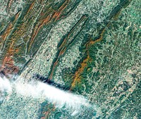
View of the USSR, Siberia area from Skylab 4. Other areas seen are Ozero, Kanka, Ussiriysk, the Sea of Japan and Kavalerovo.…![Apollo 9 Mission image - S0-65 Multispectral Photography - New Mexico. Original from NASA. Digitally enhanced by rawpixel.]() Apollo 9 Mission image - S0-65 Multispectral Photography - New Mexico. Original from NASA. Digitally enhanced by rawpixel.
Apollo 9 Mission image - S0-65 Multispectral Photography - New Mexico. Original from NASA. Digitally enhanced by rawpixel.![Simulated natural color image of Huron, South Dakota, captured by NASA's Terra spacecraft. Original from NASA. Digitally…]() Simulated natural color image of Huron, South Dakota, captured by NASA's Terra spacecraft. Original from NASA. Digitally…
Simulated natural color image of Huron, South Dakota, captured by NASA's Terra spacecraft. Original from NASA. Digitally…![After school program Instagram post template, editable text]() After school program Instagram post template, editable text
After school program Instagram post template, editable textTrending Design
![Phytoplankton bloom in the Bay of Biscay. Original from NASA. Digitally enhanced by rawpixel.]() Phytoplankton bloom in the Bay of Biscay. Original from NASA. Digitally enhanced by rawpixel.
Phytoplankton bloom in the Bay of Biscay. Original from NASA. Digitally enhanced by rawpixel.![Every southern spring and summer, after the Sun has risen into its 24-hour circuit around the skies of Antarctica, the Ross…]() Every southern spring and summer, after the Sun has risen into its 24-hour circuit around the skies of Antarctica, the Ross…
Every southern spring and summer, after the Sun has risen into its 24-hour circuit around the skies of Antarctica, the Ross…![Central area of Ethiopia, south of Addis Ababa, showing Lakes Zwai, Langana, and Shala. Original from NASA. Digitally…]() Central area of Ethiopia, south of Addis Ababa, showing Lakes Zwai, Langana, and Shala. Original from NASA. Digitally…
Central area of Ethiopia, south of Addis Ababa, showing Lakes Zwai, Langana, and Shala. Original from NASA. Digitally…![Eruption of Cleveland Volcano, Aleutian Islands, Alaska. Original from NASA. Digitally enhanced by rawpixel.]() Eruption of Cleveland Volcano, Aleutian Islands, Alaska. Original from NASA. Digitally enhanced by rawpixel.
Eruption of Cleveland Volcano, Aleutian Islands, Alaska. Original from NASA. Digitally enhanced by rawpixel.![View of portion of Queensland, Australia from Skylab space station. Original from NASA. Digitally enhanced by rawpixel]() View of portion of Queensland, Australia from Skylab space station. Original from NASA. Digitally enhanced by rawpixel
View of portion of Queensland, Australia from Skylab space station. Original from NASA. Digitally enhanced by rawpixel![The meandering Ohio River bisecting this image is the border between Kentucky and Indiana. Original from NASA. Digitally…]() The meandering Ohio River bisecting this image is the border between Kentucky and Indiana. Original from NASA. Digitally…
The meandering Ohio River bisecting this image is the border between Kentucky and Indiana. Original from NASA. Digitally…![Image showing the west coast of Greenland, one of Earth's premiere incubators for icebergs. Original from NASA. Digitally…]() Image showing the west coast of Greenland, one of Earth's premiere incubators for icebergs. Original from NASA. Digitally…
Image showing the west coast of Greenland, one of Earth's premiere incubators for icebergs. Original from NASA. Digitally…![The Arctic Circle cuts through the western coast of Norway and the Saltfjellet-Svartisen National Park. Original from NASA.…]() The Arctic Circle cuts through the western coast of Norway and the Saltfjellet-Svartisen National Park. Original from NASA.…
The Arctic Circle cuts through the western coast of Norway and the Saltfjellet-Svartisen National Park. Original from NASA.…![Parts of the vast Ganges delta, in fact the world's largest, lie in both Bangladesh and the State of West Bengal, India.…]() Parts of the vast Ganges delta, in fact the world's largest, lie in both Bangladesh and the State of West Bengal, India.…
Parts of the vast Ganges delta, in fact the world's largest, lie in both Bangladesh and the State of West Bengal, India.…![Longyearbyen, the largest island of the Svalbard archipelago, part of the Kingdom of Norway. Original from NASA. Digitally…]() Longyearbyen, the largest island of the Svalbard archipelago, part of the Kingdom of Norway. Original from NASA. Digitally…
Longyearbyen, the largest island of the Svalbard archipelago, part of the Kingdom of Norway. Original from NASA. Digitally…![Skylab 3 Earth view of the Grand Canyon, Lake Mead and Kaibab. Original from NASA. Digitally enhanced by rawpixel.]() Skylab 3 Earth view of the Grand Canyon, Lake Mead and Kaibab. Original from NASA. Digitally enhanced by rawpixel.
Skylab 3 Earth view of the Grand Canyon, Lake Mead and Kaibab. Original from NASA. Digitally enhanced by rawpixel.![Nuuk (or Gadthab) is the capital and largest city of Greenland. Original from NASA. Digitally enhanced by rawpixel]() Nuuk (or Gadthab) is the capital and largest city of Greenland. Original from NASA. Digitally enhanced by rawpixel
Nuuk (or Gadthab) is the capital and largest city of Greenland. Original from NASA. Digitally enhanced by rawpixel![Little Bahama Bank, the most northerly of the island groups that comprise the Bahamas. Original from NASA. Digitally…]() Little Bahama Bank, the most northerly of the island groups that comprise the Bahamas. Original from NASA. Digitally…
Little Bahama Bank, the most northerly of the island groups that comprise the Bahamas. Original from NASA. Digitally…![In this mostly cloud-free true-color scene, much of Scandinavia can be seen to be still covered by snow. Original from NASA.…]() In this mostly cloud-free true-color scene, much of Scandinavia can be seen to be still covered by snow. Original from NASA.…
In this mostly cloud-free true-color scene, much of Scandinavia can be seen to be still covered by snow. Original from NASA.…![Northern half of Mauritania's Atlantic Coast from Skylab. Original from NASA. Digitally enhanced by rawpixel.]() Northern half of Mauritania's Atlantic Coast from Skylab. Original from NASA. Digitally enhanced by rawpixel.
Northern half of Mauritania's Atlantic Coast from Skylab. Original from NASA. Digitally enhanced by rawpixel.![This image from NASA's Terra spacecraft shows Beihai, a city in the south of Guangxi, People's republic of China. Original…]() This image from NASA's Terra spacecraft shows Beihai, a city in the south of Guangxi, People's republic of China. Original…
This image from NASA's Terra spacecraft shows Beihai, a city in the south of Guangxi, People's republic of China. Original…![Nadir view of the southern Cape District of South Africa. Original from NASA. Digitally enhanced by rawpixel.]() Nadir view of the southern Cape District of South Africa. Original from NASA. Digitally enhanced by rawpixel.
Nadir view of the southern Cape District of South Africa. Original from NASA. Digitally enhanced by rawpixel.![NASA's Wallops Flight Facility is located on Wallops Island. Satellite imagery from NOAA's GOES-East satellite shows that…]() NASA's Wallops Flight Facility is located on Wallops Island. Satellite imagery from NOAA's GOES-East satellite shows that…
NASA's Wallops Flight Facility is located on Wallops Island. Satellite imagery from NOAA's GOES-East satellite shows that…![Rio Gurupi in the Brazilian state of Maranhao and its delta.Original from NASA. Digitally enhanced by rawpixel.]() Rio Gurupi in the Brazilian state of Maranhao and its delta.Original from NASA. Digitally enhanced by rawpixel.
Rio Gurupi in the Brazilian state of Maranhao and its delta.Original from NASA. Digitally enhanced by rawpixel.![Climate change Instagram post template, editable text]() Climate change Instagram post template, editable text
Climate change Instagram post template, editable textTrending Design
![Al Jazirah (also Gezira) is one of the 26 states of Sudan. Original from NASA. Digitally enhanced by rawpixel.]() Al Jazirah (also Gezira) is one of the 26 states of Sudan. Original from NASA. Digitally enhanced by rawpixel.
Al Jazirah (also Gezira) is one of the 26 states of Sudan. Original from NASA. Digitally enhanced by rawpixel.![Greens and blues of the ocean color from NASA satellite data. Original from NASA. Digitally enhanced by rawpixel.]() Greens and blues of the ocean color from NASA satellite data. Original from NASA. Digitally enhanced by rawpixel.
Greens and blues of the ocean color from NASA satellite data. Original from NASA. Digitally enhanced by rawpixel.![The Kondyor Massif is located in Eastern Siberia, Russia, north of the city of Khabarovsk. Original from NASA. Digitally…]() The Kondyor Massif is located in Eastern Siberia, Russia, north of the city of Khabarovsk. Original from NASA. Digitally…
The Kondyor Massif is located in Eastern Siberia, Russia, north of the city of Khabarovsk. Original from NASA. Digitally…![The Uvs Nuur Basin in Mongolia and the Russian Federation. Original from NASA. Digitally enhanced by rawpixel.]() The Uvs Nuur Basin in Mongolia and the Russian Federation. Original from NASA. Digitally enhanced by rawpixel.
The Uvs Nuur Basin in Mongolia and the Russian Federation. Original from NASA. Digitally enhanced by rawpixel.![Lake Naivasha, 90km north-west of Nairobi. Original from NASA. Digitally enhanced by rawpixel.]() Lake Naivasha, 90km north-west of Nairobi. Original from NASA. Digitally enhanced by rawpixel.
Lake Naivasha, 90km north-west of Nairobi. Original from NASA. Digitally enhanced by rawpixel.![This image from NASA's Terra spacecraft shows the Kuk Early Agricultural Site in the western highlands of New Guinea.…]() This image from NASA's Terra spacecraft shows the Kuk Early Agricultural Site in the western highlands of New Guinea.…
This image from NASA's Terra spacecraft shows the Kuk Early Agricultural Site in the western highlands of New Guinea.…![View of the southeastern tip of the Arabian Peninsula with the Gulf of Oman at upper right. Original from NASA . Digitally…]() View of the southeastern tip of the Arabian Peninsula with the Gulf of Oman at upper right. Original from NASA . Digitally…
View of the southeastern tip of the Arabian Peninsula with the Gulf of Oman at upper right. Original from NASA . Digitally…![View of the Salt Lake City, Utah area. Original from NASA. Digitally enhanced by rawpixel.]() View of the Salt Lake City, Utah area. Original from NASA. Digitally enhanced by rawpixel.
View of the Salt Lake City, Utah area. Original from NASA. Digitally enhanced by rawpixel.![Arabian Peninsula and northeast Africa as seen from the orbiting Gemini-11. Original from NASA. Digitally enhanced by…]() Arabian Peninsula and northeast Africa as seen from the orbiting Gemini-11. Original from NASA. Digitally enhanced by…
Arabian Peninsula and northeast Africa as seen from the orbiting Gemini-11. Original from NASA. Digitally enhanced by…![Iran, Trucial Coast, Oman, Zagros Mountains, and Qishm Island (large island at lower left), as seen from the Gemini-12…]() Iran, Trucial Coast, Oman, Zagros Mountains, and Qishm Island (large island at lower left), as seen from the Gemini-12…
Iran, Trucial Coast, Oman, Zagros Mountains, and Qishm Island (large island at lower left), as seen from the Gemini-12…![This image from NASA's EarthKAM shows Lisbon, the capital of Portugal. Original from NASA. Digitally enhanced by rawpixel.]() This image from NASA's EarthKAM shows Lisbon, the capital of Portugal. Original from NASA. Digitally enhanced by rawpixel.
This image from NASA's EarthKAM shows Lisbon, the capital of Portugal. Original from NASA. Digitally enhanced by rawpixel.![Skylab 3 Earth view of the Nile Delta, Egypt and Suez Canal. Original from NASA. Digitally enhanced by rawpixel.]() Skylab 3 Earth view of the Nile Delta, Egypt and Suez Canal. Original from NASA. Digitally enhanced by rawpixel.
Skylab 3 Earth view of the Nile Delta, Egypt and Suez Canal. Original from NASA. Digitally enhanced by rawpixel.![The Isthmus of Corinth has played a very important role in the history of Greece. Original from NASA. Digitally enhanced by…]() The Isthmus of Corinth has played a very important role in the history of Greece. Original from NASA. Digitally enhanced by…
The Isthmus of Corinth has played a very important role in the history of Greece. Original from NASA. Digitally enhanced by…![This image from NASA's EarthKAM captures almost all of Quinghai, the largest lake in China. Original from NASA. Digitally…]() This image from NASA's EarthKAM captures almost all of Quinghai, the largest lake in China. Original from NASA. Digitally…
This image from NASA's EarthKAM captures almost all of Quinghai, the largest lake in China. Original from NASA. Digitally…![Snow, which tends to be generally less bright that clouds, covers the Alps in the north of Italy. Original from NASA.…]() Snow, which tends to be generally less bright that clouds, covers the Alps in the north of Italy. Original from NASA.…
Snow, which tends to be generally less bright that clouds, covers the Alps in the north of Italy. Original from NASA.…![Isles of Scilly, United Kingdom. Original from NASA. Digitally enhanced by rawpixel.]() Isles of Scilly, United Kingdom. Original from NASA. Digitally enhanced by rawpixel.
Isles of Scilly, United Kingdom. Original from NASA. Digitally enhanced by rawpixel.![Dendi Caldera, Ethiopia is featured in this image photographed by an Expedition 16 crew member on the International Space…]() Dendi Caldera, Ethiopia is featured in this image photographed by an Expedition 16 crew member on the International Space…
Dendi Caldera, Ethiopia is featured in this image photographed by an Expedition 16 crew member on the International Space…![Lake Ilopango, a crater lake which fills a volcanic caldera in central El Salvador. Original from NASA. Digitally enhanced…]() Lake Ilopango, a crater lake which fills a volcanic caldera in central El Salvador. Original from NASA. Digitally enhanced…
Lake Ilopango, a crater lake which fills a volcanic caldera in central El Salvador. Original from NASA. Digitally enhanced…![The STS-93 astronauts aboard the Space Shuttle Columbia took this picture over the Indian Ocean on 23-27 July 1999. Original…]() The STS-93 astronauts aboard the Space Shuttle Columbia took this picture over the Indian Ocean on 23-27 July 1999. Original…
The STS-93 astronauts aboard the Space Shuttle Columbia took this picture over the Indian Ocean on 23-27 July 1999. Original…![Earth observation by the crew of the International Space Station. Original from NASA. Digitally enhanced by rawpixel.]() Earth observation by the crew of the International Space Station. Original from NASA. Digitally enhanced by rawpixel.
Earth observation by the crew of the International Space Station. Original from NASA. Digitally enhanced by rawpixel.![A plume at Shiveluch Volcano, Kamchatka Peninsula, Russia. Original from NASA. Digitally enhanced by rawpixel.]() A plume at Shiveluch Volcano, Kamchatka Peninsula, Russia. Original from NASA. Digitally enhanced by rawpixel.
A plume at Shiveluch Volcano, Kamchatka Peninsula, Russia. Original from NASA. Digitally enhanced by rawpixel.![Aerial view of Berlin, acquired by NASA's Terra spacecraft. Original from NASA. Digitally enhanced by rawpixel.]() Aerial view of Berlin, acquired by NASA's Terra spacecraft. Original from NASA. Digitally enhanced by rawpixel.
Aerial view of Berlin, acquired by NASA's Terra spacecraft. Original from NASA. Digitally enhanced by rawpixel.![NASA Satellite Captures Super Bowl Cities - Santa Clara, CA .Original from NASA. Digitally enhanced by rawpixel.]() NASA Satellite Captures Super Bowl Cities - Santa Clara, CA .Original from NASA. Digitally enhanced by rawpixel.
NASA Satellite Captures Super Bowl Cities - Santa Clara, CA .Original from NASA. Digitally enhanced by rawpixel.![Nearly cloud-free view of Great Britain and Ireland was acquired by the Moderate Resolution Imaging Spectroradiometer aboard…]() Nearly cloud-free view of Great Britain and Ireland was acquired by the Moderate Resolution Imaging Spectroradiometer aboard…
Nearly cloud-free view of Great Britain and Ireland was acquired by the Moderate Resolution Imaging Spectroradiometer aboard…![Attu, the westernmost Aleutian island, is nearly 1760 km from the Alaskan mainland. Original from NASA. Digitally enhanced…]() Attu, the westernmost Aleutian island, is nearly 1760 km from the Alaskan mainland. Original from NASA. Digitally enhanced…
Attu, the westernmost Aleutian island, is nearly 1760 km from the Alaskan mainland. Original from NASA. Digitally enhanced…![This image of the Galapagos Islands captures two large shield volcanoes on Isla Isabella. Original from NASA. Digitally…]() This image of the Galapagos Islands captures two large shield volcanoes on Isla Isabella. Original from NASA. Digitally…
This image of the Galapagos Islands captures two large shield volcanoes on Isla Isabella. Original from NASA. Digitally…![View of the Arctic waters and the far northern lands surrounding it. Original from NASA. Digitally enhanced by rawpixel.]() View of the Arctic waters and the far northern lands surrounding it. Original from NASA. Digitally enhanced by rawpixel.
View of the Arctic waters and the far northern lands surrounding it. Original from NASA. Digitally enhanced by rawpixel.![Savannah River Site, South Carolina. Original from NASA. Digitally enhanced by rawpixel.]() Savannah River Site, South Carolina. Original from NASA. Digitally enhanced by rawpixel.
Savannah River Site, South Carolina. Original from NASA. Digitally enhanced by rawpixel.![Teshekpuk Lake on Alaska's North Slope, within the National Petroleum Reserve. Original from NASA. Digitally enhanced by…]() Teshekpuk Lake on Alaska's North Slope, within the National Petroleum Reserve. Original from NASA. Digitally enhanced by…
Teshekpuk Lake on Alaska's North Slope, within the National Petroleum Reserve. Original from NASA. Digitally enhanced by…![Sheveluch Volcano in Kamchatka, Siberia. Original from NASA. Digitally enhanced by rawpixel.]() Sheveluch Volcano in Kamchatka, Siberia. Original from NASA. Digitally enhanced by rawpixel.
Sheveluch Volcano in Kamchatka, Siberia. Original from NASA. Digitally enhanced by rawpixel.![Rostov-on-Don, a Russian City on the Don River, 32 kilometers from the Sea of Azov. Original from NASA. Digitally enhanced…]() Rostov-on-Don, a Russian City on the Don River, 32 kilometers from the Sea of Azov. Original from NASA. Digitally enhanced…
Rostov-on-Don, a Russian City on the Don River, 32 kilometers from the Sea of Azov. Original from NASA. Digitally enhanced…![Missionary Plains in Australia’s Northern Territory, a crater 24 kilometers in diameter and 5 kilometers deep.…]() Missionary Plains in Australia’s Northern Territory, a crater 24 kilometers in diameter and 5 kilometers deep.…
Missionary Plains in Australia’s Northern Territory, a crater 24 kilometers in diameter and 5 kilometers deep.…![Baja California, Colorado river and Sonora Desert. Original from NASA. Digitally enhanced by rawpixel.]() Baja California, Colorado river and Sonora Desert. Original from NASA. Digitally enhanced by rawpixel.
Baja California, Colorado river and Sonora Desert. Original from NASA. Digitally enhanced by rawpixel.![Early Melt on the Greenland Ice Sheet . Original from NASA . Digitally enhanced by rawpixel.]() Early Melt on the Greenland Ice Sheet . Original from NASA . Digitally enhanced by rawpixel.
Early Melt on the Greenland Ice Sheet . Original from NASA . Digitally enhanced by rawpixel.![Snow covered Alps of France, Italy, and Switzerland. Original from NASA. Digitally enhanced by rawpixel.]() Snow covered Alps of France, Italy, and Switzerland. Original from NASA. Digitally enhanced by rawpixel.
Snow covered Alps of France, Italy, and Switzerland. Original from NASA. Digitally enhanced by rawpixel.![Sediment Spews from Connecticut River. Original from NASA. Digitally enhanced by rawpixel.]() Sediment Spews from Connecticut River. Original from NASA. Digitally enhanced by rawpixel.
Sediment Spews from Connecticut River. Original from NASA. Digitally enhanced by rawpixel.![This is an 800mm oblique view which covers an area including Moffett Federal Air Field, NASA's Ames Research Center…]() This is an 800mm oblique view which covers an area including Moffett Federal Air Field, NASA's Ames Research Center…
This is an 800mm oblique view which covers an area including Moffett Federal Air Field, NASA's Ames Research Center…![Moffett Federal Air Field, NASA Ames Research Center and Silicon Valley. Original from NASA. Digitally enhanced by rawpixel.]() Moffett Federal Air Field, NASA Ames Research Center and Silicon Valley. Original from NASA. Digitally enhanced by rawpixel.
Moffett Federal Air Field, NASA Ames Research Center and Silicon Valley. Original from NASA. Digitally enhanced by rawpixel.![Lower Chesapeake Bay, VA, USA. Original from NASA. Digitally enhanced by rawpixel.]() Lower Chesapeake Bay, VA, USA. Original from NASA. Digitally enhanced by rawpixel.
Lower Chesapeake Bay, VA, USA. Original from NASA. Digitally enhanced by rawpixel.![Torrential rains in the mid-South of the United States in mid-March 2016 produced flooding throughout Texas, Louisiana and…]() Torrential rains in the mid-South of the United States in mid-March 2016 produced flooding throughout Texas, Louisiana and…
Torrential rains in the mid-South of the United States in mid-March 2016 produced flooding throughout Texas, Louisiana and…![Beautiful new mosaic of Chesapeake Bay. Original from NASA. Digitally enhanced by rawpixel.]() Beautiful new mosaic of Chesapeake Bay. Original from NASA. Digitally enhanced by rawpixel.
Beautiful new mosaic of Chesapeake Bay. Original from NASA. Digitally enhanced by rawpixel.![NASA image acquired August 17, 2010, the Northwest Passage almost free of ice. Original from NASA. Digitally enhanced by…]() NASA image acquired August 17, 2010, the Northwest Passage almost free of ice. Original from NASA. Digitally enhanced by…
NASA image acquired August 17, 2010, the Northwest Passage almost free of ice. Original from NASA. Digitally enhanced by…![San Francisco and Bay Area, CA, USA. Original from NASA. Digitally enhanced by rawpixel.]() San Francisco and Bay Area, CA, USA. Original from NASA. Digitally enhanced by rawpixel.
San Francisco and Bay Area, CA, USA. Original from NASA. Digitally enhanced by rawpixel.![The Matusevich Glacier flows toward the coast of East Antarctica, pushing through a channel between the Lazarev Mountains…]() The Matusevich Glacier flows toward the coast of East Antarctica, pushing through a channel between the Lazarev Mountains…
The Matusevich Glacier flows toward the coast of East Antarctica, pushing through a channel between the Lazarev Mountains…![Parts of Galveston and Harris Counties and Galveston Bay and several communities in the Clear Lake area. Original from NASA.…]() Parts of Galveston and Harris Counties and Galveston Bay and several communities in the Clear Lake area. Original from NASA.…
Parts of Galveston and Harris Counties and Galveston Bay and several communities in the Clear Lake area. Original from NASA.…![Calcite Quarry, Michigan. Original from NASA. Digitally enhanced by rawpixel.]() Calcite Quarry, Michigan. Original from NASA. Digitally enhanced by rawpixel.
Calcite Quarry, Michigan. Original from NASA. Digitally enhanced by rawpixel.![A perfect sunset over NASA's Kennedy Space Center in Florida. Original from NASA. Digitally enhanced by rawpixel.]() A perfect sunset over NASA's Kennedy Space Center in Florida. Original from NASA. Digitally enhanced by rawpixel.
A perfect sunset over NASA's Kennedy Space Center in Florida. Original from NASA. Digitally enhanced by rawpixel.![Cosiguina Volcano, Nicaragua. Original from NASA. Digitally enhanced by rawpixel.]() Cosiguina Volcano, Nicaragua. Original from NASA. Digitally enhanced by rawpixel.
Cosiguina Volcano, Nicaragua. Original from NASA. Digitally enhanced by rawpixel.![This spaceborne radar image shows the area just north of the city of Cairo, Egypt, where the Nile River splits into two main…]() This spaceborne radar image shows the area just north of the city of Cairo, Egypt, where the Nile River splits into two main…
This spaceborne radar image shows the area just north of the city of Cairo, Egypt, where the Nile River splits into two main…![A perfect sunset over NASA's Kennedy Space Center in Florida. Original from NASA. Digitally enhanced by rawpixel.]() A perfect sunset over NASA's Kennedy Space Center in Florida. Original from NASA. Digitally enhanced by rawpixel.
A perfect sunset over NASA's Kennedy Space Center in Florida. Original from NASA. Digitally enhanced by rawpixel.![A perfect sunset over NASA's Kennedy Space Center in Florida. Original from NASA. Digitally enhanced by rawpixel.]() A perfect sunset over NASA's Kennedy Space Center in Florida. Original from NASA. Digitally enhanced by rawpixel.
A perfect sunset over NASA's Kennedy Space Center in Florida. Original from NASA. Digitally enhanced by rawpixel.![The John F. Kennedy Space Center, America's spaceport, is located along Florida's eastern shore on Cape Canaveral. Original…]() The John F. Kennedy Space Center, America's spaceport, is located along Florida's eastern shore on Cape Canaveral. Original…
The John F. Kennedy Space Center, America's spaceport, is located along Florida's eastern shore on Cape Canaveral. Original…![Edge of an ice shelf in Adelaide Island, off the Antarctic Peninsula. Original from NASA. Digitally enhanced by rawpixel.]() Edge of an ice shelf in Adelaide Island, off the Antarctic Peninsula. Original from NASA. Digitally enhanced by rawpixel.
Edge of an ice shelf in Adelaide Island, off the Antarctic Peninsula. Original from NASA. Digitally enhanced by rawpixel.![Saunders Island and Wolstenholme Fjord with Kap Atholl in the background. Original from NASA. Digitally enhanced by rawpixel.]() Saunders Island and Wolstenholme Fjord with Kap Atholl in the background. Original from NASA. Digitally enhanced by rawpixel.
Saunders Island and Wolstenholme Fjord with Kap Atholl in the background. Original from NASA. Digitally enhanced by rawpixel.![A NASA scientific balloon awaits launch in McMurdo, Antarctica. Original from NASA. Digitally enhanced by rawpixel.]() A NASA scientific balloon awaits launch in McMurdo, Antarctica. Original from NASA. Digitally enhanced by rawpixel.
A NASA scientific balloon awaits launch in McMurdo, Antarctica. Original from NASA. Digitally enhanced by rawpixel.![NASA’s Operation IceBridge Completes Twin Polar Campaigns. Heimdal Glacier in southern Greenland. Original from NASA.…]() NASA’s Operation IceBridge Completes Twin Polar Campaigns. Heimdal Glacier in southern Greenland. Original from NASA.…
NASA’s Operation IceBridge Completes Twin Polar Campaigns. Heimdal Glacier in southern Greenland. Original from NASA.…![An iceberg trapped in sea ice in the Amundsen Sea. Original from NASA. Digitally enhanced by rawpixel.]() An iceberg trapped in sea ice in the Amundsen Sea. Original from NASA. Digitally enhanced by rawpixel.
An iceberg trapped in sea ice in the Amundsen Sea. Original from NASA. Digitally enhanced by rawpixel.![The remnant pilings of a long-gone dock appear to float in air due to their reflection in the blue, still water of a pond…]() The remnant pilings of a long-gone dock appear to float in air due to their reflection in the blue, still water of a pond…
The remnant pilings of a long-gone dock appear to float in air due to their reflection in the blue, still water of a pond…![Arrival of the RRS Ernest Shackleton near Halley Research Station in Antarctica, January, 2013. Original from NASA.…]() Arrival of the RRS Ernest Shackleton near Halley Research Station in Antarctica, January, 2013. Original from NASA.…
Arrival of the RRS Ernest Shackleton near Halley Research Station in Antarctica, January, 2013. Original from NASA.…![The terrain for the scientific work conducted by ICESCAPE scientists on July 4, 2010. Original from NASA. Digitally enhanced…]() The terrain for the scientific work conducted by ICESCAPE scientists on July 4, 2010. Original from NASA. Digitally enhanced…
The terrain for the scientific work conducted by ICESCAPE scientists on July 4, 2010. Original from NASA. Digitally enhanced…![View of the northern Antarctic Peninsula from high altitude during IceBridge's flight back from the Foundation Ice Stream…]() View of the northern Antarctic Peninsula from high altitude during IceBridge's flight back from the Foundation Ice Stream…
View of the northern Antarctic Peninsula from high altitude during IceBridge's flight back from the Foundation Ice Stream…![The U.S. Coast Guard Cutter Healy encountered only small patches of sea ice in the Chukchi Sea during the final days…]() The U.S. Coast Guard Cutter Healy encountered only small patches of sea ice in the Chukchi Sea during the final days…
The U.S. Coast Guard Cutter Healy encountered only small patches of sea ice in the Chukchi Sea during the final days…![Ice on the Ellsworth Range in Antarctica as seen from the IceBridge DC-8 on Oct. 22, 2012. Original from NASA. Digitally…]() Ice on the Ellsworth Range in Antarctica as seen from the IceBridge DC-8 on Oct. 22, 2012. Original from NASA. Digitally…
Ice on the Ellsworth Range in Antarctica as seen from the IceBridge DC-8 on Oct. 22, 2012. Original from NASA. Digitally…![On July 20, the U.S. Coast Guard Cutter Healy steamed south in the Arctic Ocean toward the edge of the sea ice. Original…]() On July 20, the U.S. Coast Guard Cutter Healy steamed south in the Arctic Ocean toward the edge of the sea ice. Original…
On July 20, the U.S. Coast Guard Cutter Healy steamed south in the Arctic Ocean toward the edge of the sea ice. Original…![Image taken by a new Earth-observing instrument installed on the international space station. Original from NASA. Digitally…]() Image taken by a new Earth-observing instrument installed on the international space station. Original from NASA. Digitally…
Image taken by a new Earth-observing instrument installed on the international space station. Original from NASA. Digitally…![A New Identity for Denali , North America’s highest peak. Original from NASA. Digitally enhanced by rawpixel.]() A New Identity for Denali , North America’s highest peak. Original from NASA. Digitally enhanced by rawpixel.
A New Identity for Denali , North America’s highest peak. Original from NASA. Digitally enhanced by rawpixel.![An iceberg embedded in sea ice as seen from the IceBridge DC-8 over the Bellingshausen Sea on Oct. 19, 2012. Original from…]() An iceberg embedded in sea ice as seen from the IceBridge DC-8 over the Bellingshausen Sea on Oct. 19, 2012. Original from…
An iceberg embedded in sea ice as seen from the IceBridge DC-8 over the Bellingshausen Sea on Oct. 19, 2012. Original from…![The Musandam Peninsula, part of Oman. Original from NASA. Digitally enhanced by rawpixel.]() The Musandam Peninsula, part of Oman. Original from NASA. Digitally enhanced by rawpixel.
The Musandam Peninsula, part of Oman. Original from NASA. Digitally enhanced by rawpixel.![The Larsen Ice Shelf in Antarctica viewed from NASA's DC-8 aircraft during the AirSAR 2004 campaign . Original from NASA.…]() The Larsen Ice Shelf in Antarctica viewed from NASA's DC-8 aircraft during the AirSAR 2004 campaign . Original from NASA.…
The Larsen Ice Shelf in Antarctica viewed from NASA's DC-8 aircraft during the AirSAR 2004 campaign . Original from NASA.…