![NASA'S SOFIA infrared observatory 747SP (front) and DC-8 flying laboratory (rear) housed at the Dryden Aircraft Operations…]() NASA'S SOFIA infrared observatory 747SP (front) and DC-8 flying laboratory (rear) housed at the Dryden Aircraft Operations…
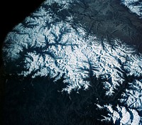
NASA'S SOFIA infrared observatory 747SP (front) and DC-8 flying laboratory (rear) housed at the Dryden Aircraft Operations…![Parts of he Kimberley region of Western Australia. Original from NASA. Digitally enhanced by rawpixel.]() Parts of he Kimberley region of Western Australia. Original from NASA. Digitally enhanced by rawpixel.
Parts of he Kimberley region of Western Australia. Original from NASA. Digitally enhanced by rawpixel.![Lying in the eastern Mediterranean Sea, the entire Island of Crete (35.0N, 25.0E) can be seen in great detail in this cloud…]() Lying in the eastern Mediterranean Sea, the entire Island of Crete (35.0N, 25.0E) can be seen in great detail in this cloud…
Lying in the eastern Mediterranean Sea, the entire Island of Crete (35.0N, 25.0E) can be seen in great detail in this cloud…![Isles of Scilly, United Kingdom. Original from NASA. Digitally enhanced by rawpixel.]() Isles of Scilly, United Kingdom. Original from NASA. Digitally enhanced by rawpixel.
Isles of Scilly, United Kingdom. Original from NASA. Digitally enhanced by rawpixel.![The Isthmus of Corinth has played a very important role in the history of Greece. Original from NASA. Digitally enhanced by…]() The Isthmus of Corinth has played a very important role in the history of Greece. Original from NASA. Digitally enhanced by…
The Isthmus of Corinth has played a very important role in the history of Greece. Original from NASA. Digitally enhanced by…![Skylab 3 Earth view of the Nile Delta, Egypt and Suez Canal. Original from NASA. Digitally enhanced by rawpixel.]() Skylab 3 Earth view of the Nile Delta, Egypt and Suez Canal. Original from NASA. Digitally enhanced by rawpixel.
Skylab 3 Earth view of the Nile Delta, Egypt and Suez Canal. Original from NASA. Digitally enhanced by rawpixel.![View of the USSR, Siberia area from Skylab 4. Other areas seen are Ozero, Kanka, Ussiriysk, the Sea of Japan and Kavalerovo.…]() View of the USSR, Siberia area from Skylab 4. Other areas seen are Ozero, Kanka, Ussiriysk, the Sea of Japan and Kavalerovo.…
View of the USSR, Siberia area from Skylab 4. Other areas seen are Ozero, Kanka, Ussiriysk, the Sea of Japan and Kavalerovo.…![View of portion of Queensland, Australia from Skylab space station. Original from NASA. Digitally enhanced by rawpixel]() View of portion of Queensland, Australia from Skylab space station. Original from NASA. Digitally enhanced by rawpixel
View of portion of Queensland, Australia from Skylab space station. Original from NASA. Digitally enhanced by rawpixel![This image from NASA's EarthKAM shows Lisbon, the capital of Portugal. Original from NASA. Digitally enhanced by rawpixel.]() This image from NASA's EarthKAM shows Lisbon, the capital of Portugal. Original from NASA. Digitally enhanced by rawpixel.
This image from NASA's EarthKAM shows Lisbon, the capital of Portugal. Original from NASA. Digitally enhanced by rawpixel.![Snow, which tends to be generally less bright that clouds, covers the Alps in the north of Italy. Original from NASA.…]() Snow, which tends to be generally less bright that clouds, covers the Alps in the north of Italy. Original from NASA.…
Snow, which tends to be generally less bright that clouds, covers the Alps in the north of Italy. Original from NASA.…![Image showing the west coast of Greenland, one of Earth's premiere incubators for icebergs. Original from NASA. Digitally…]() Image showing the west coast of Greenland, one of Earth's premiere incubators for icebergs. Original from NASA. Digitally…
Image showing the west coast of Greenland, one of Earth's premiere incubators for icebergs. Original from NASA. Digitally…![This image from NASA's EarthKAM captures almost all of Quinghai, the largest lake in China. Original from NASA. Digitally…]() This image from NASA's EarthKAM captures almost all of Quinghai, the largest lake in China. Original from NASA. Digitally…
This image from NASA's EarthKAM captures almost all of Quinghai, the largest lake in China. Original from NASA. Digitally…![China, India, and Nepal as seen from Gemini 11. Original from NASA. Digitally enhanced by rawpixel.]() China, India, and Nepal as seen from Gemini 11. Original from NASA. Digitally enhanced by rawpixel.
China, India, and Nepal as seen from Gemini 11. Original from NASA. Digitally enhanced by rawpixel.![Savannah River Site, South Carolina. Original from NASA. Digitally enhanced by rawpixel.]() Savannah River Site, South Carolina. Original from NASA. Digitally enhanced by rawpixel.
Savannah River Site, South Carolina. Original from NASA. Digitally enhanced by rawpixel.![Attu, the westernmost Aleutian island, is nearly 1760 km from the Alaskan mainland. Original from NASA. Digitally enhanced…]() Attu, the westernmost Aleutian island, is nearly 1760 km from the Alaskan mainland. Original from NASA. Digitally enhanced…
Attu, the westernmost Aleutian island, is nearly 1760 km from the Alaskan mainland. Original from NASA. Digitally enhanced…![Lake Ilopango, a crater lake which fills a volcanic caldera in central El Salvador. Original from NASA. Digitally enhanced…]() Lake Ilopango, a crater lake which fills a volcanic caldera in central El Salvador. Original from NASA. Digitally enhanced…
Lake Ilopango, a crater lake which fills a volcanic caldera in central El Salvador. Original from NASA. Digitally enhanced…![A plume at Shiveluch Volcano, Kamchatka Peninsula, Russia. Original from NASA. Digitally enhanced by rawpixel.]() A plume at Shiveluch Volcano, Kamchatka Peninsula, Russia. Original from NASA. Digitally enhanced by rawpixel.
A plume at Shiveluch Volcano, Kamchatka Peninsula, Russia. Original from NASA. Digitally enhanced by rawpixel.![Earth observation by the crew of the International Space Station. Original from NASA. Digitally enhanced by rawpixel.]() Earth observation by the crew of the International Space Station. Original from NASA. Digitally enhanced by rawpixel.
Earth observation by the crew of the International Space Station. Original from NASA. Digitally enhanced by rawpixel.![Central area of Ethiopia, south of Addis Ababa, showing Lakes Zwai, Langana, and Shala. Original from NASA. Digitally…]() Central area of Ethiopia, south of Addis Ababa, showing Lakes Zwai, Langana, and Shala. Original from NASA. Digitally…
Central area of Ethiopia, south of Addis Ababa, showing Lakes Zwai, Langana, and Shala. Original from NASA. Digitally…![This is an 800mm oblique view which covers an area including Moffett Federal Air Field, NASA's Ames Research Center…]() This is an 800mm oblique view which covers an area including Moffett Federal Air Field, NASA's Ames Research Center…
This is an 800mm oblique view which covers an area including Moffett Federal Air Field, NASA's Ames Research Center…![Teshekpuk Lake on Alaska's North Slope, within the National Petroleum Reserve. Original from NASA. Digitally enhanced by…]() Teshekpuk Lake on Alaska's North Slope, within the National Petroleum Reserve. Original from NASA. Digitally enhanced by…
Teshekpuk Lake on Alaska's North Slope, within the National Petroleum Reserve. Original from NASA. Digitally enhanced by…![Sheveluch Volcano in Kamchatka, Siberia. Original from NASA. Digitally enhanced by rawpixel.]() Sheveluch Volcano in Kamchatka, Siberia. Original from NASA. Digitally enhanced by rawpixel.
Sheveluch Volcano in Kamchatka, Siberia. Original from NASA. Digitally enhanced by rawpixel.![Dendi Caldera, Ethiopia is featured in this image photographed by an Expedition 16 crew member on the International Space…]() Dendi Caldera, Ethiopia is featured in this image photographed by an Expedition 16 crew member on the International Space…
Dendi Caldera, Ethiopia is featured in this image photographed by an Expedition 16 crew member on the International Space…![The terrain for the scientific work conducted by ICESCAPE scientists on July 4, 2010. Original from NASA. Digitally enhanced…]() The terrain for the scientific work conducted by ICESCAPE scientists on July 4, 2010. Original from NASA. Digitally enhanced…
The terrain for the scientific work conducted by ICESCAPE scientists on July 4, 2010. Original from NASA. Digitally enhanced…![Arrival of the RRS Ernest Shackleton near Halley Research Station in Antarctica, January, 2013. Original from NASA.…]() Arrival of the RRS Ernest Shackleton near Halley Research Station in Antarctica, January, 2013. Original from NASA.…
Arrival of the RRS Ernest Shackleton near Halley Research Station in Antarctica, January, 2013. Original from NASA.…![Himalayan salt mineral recipe ingredient]() Himalayan salt mineral recipe ingredient
Himalayan salt mineral recipe ingredient![Herd of Sheeps Goats on Hill]() Herd of Sheeps Goats on Hill
Herd of Sheeps Goats on Hill![View of the southeastern tip of the Arabian Peninsula with the Gulf of Oman at upper right. Original from NASA . Digitally…]() View of the southeastern tip of the Arabian Peninsula with the Gulf of Oman at upper right. Original from NASA . Digitally…
View of the southeastern tip of the Arabian Peninsula with the Gulf of Oman at upper right. Original from NASA . Digitally…![Ice on the Ellsworth Range in Antarctica as seen from the IceBridge DC-8 on Oct. 22, 2012. Original from NASA. Digitally…]() Ice on the Ellsworth Range in Antarctica as seen from the IceBridge DC-8 on Oct. 22, 2012. Original from NASA. Digitally…
Ice on the Ellsworth Range in Antarctica as seen from the IceBridge DC-8 on Oct. 22, 2012. Original from NASA. Digitally…![View of the northern Antarctic Peninsula from high altitude during IceBridge's flight back from the Foundation Ice Stream…]() View of the northern Antarctic Peninsula from high altitude during IceBridge's flight back from the Foundation Ice Stream…
View of the northern Antarctic Peninsula from high altitude during IceBridge's flight back from the Foundation Ice Stream…![New image of the Earth at night is a composite assembled from data acquired by the Suomi National Polar-orbiting Partnership…]() New image of the Earth at night is a composite assembled from data acquired by the Suomi National Polar-orbiting Partnership…
New image of the Earth at night is a composite assembled from data acquired by the Suomi National Polar-orbiting Partnership…![At Cape Canaveral Air Force Station in Florida, NASA's Juno spacecraft, is being transported from the Atlas Spaceflight…]() At Cape Canaveral Air Force Station in Florida, NASA's Juno spacecraft, is being transported from the Atlas Spaceflight…
At Cape Canaveral Air Force Station in Florida, NASA's Juno spacecraft, is being transported from the Atlas Spaceflight…![Delhi, the second largest metropolis in India, with a population of 16 million. Original from NASA. Digitally enhanced by…]() Delhi, the second largest metropolis in India, with a population of 16 million. Original from NASA. Digitally enhanced by…
Delhi, the second largest metropolis in India, with a population of 16 million. Original from NASA. Digitally enhanced by…![Image taken by a new Earth-observing instrument installed on the international space station. Original from NASA. Digitally…]() Image taken by a new Earth-observing instrument installed on the international space station. Original from NASA. Digitally…
Image taken by a new Earth-observing instrument installed on the international space station. Original from NASA. Digitally…![Lake Torrens and the Australian Outback. Original from NASA. Digitally enhanced by rawpixel.]() Lake Torrens and the Australian Outback. Original from NASA. Digitally enhanced by rawpixel.
Lake Torrens and the Australian Outback. Original from NASA. Digitally enhanced by rawpixel.![Flood waters in Bangkok as the Ayutthaya River overflowed its banks. Original from NASA. Digitally enhanced by rawpixel.]() Flood waters in Bangkok as the Ayutthaya River overflowed its banks. Original from NASA. Digitally enhanced by rawpixel.
Flood waters in Bangkok as the Ayutthaya River overflowed its banks. Original from NASA. Digitally enhanced by rawpixel.![A New Identity for Denali , North America’s highest peak. Original from NASA. Digitally enhanced by rawpixel.]() A New Identity for Denali , North America’s highest peak. Original from NASA. Digitally enhanced by rawpixel.
A New Identity for Denali , North America’s highest peak. Original from NASA. Digitally enhanced by rawpixel.![View of Minneapolis-St.Paul, Minnesota area. Original from NASA. Digitally enhanced by rawpixel.]() View of Minneapolis-St.Paul, Minnesota area. Original from NASA. Digitally enhanced by rawpixel.
View of Minneapolis-St.Paul, Minnesota area. Original from NASA. Digitally enhanced by rawpixel.![Snow covered Alps of France, Italy, and Switzerland. Original from NASA. Digitally enhanced by rawpixel.]() Snow covered Alps of France, Italy, and Switzerland. Original from NASA. Digitally enhanced by rawpixel.
Snow covered Alps of France, Italy, and Switzerland. Original from NASA. Digitally enhanced by rawpixel.![This rare cloud-free view of southern Italy shows almost all of the famous `boot' configuration of the peninsula up to just…]() This rare cloud-free view of southern Italy shows almost all of the famous `boot' configuration of the peninsula up to just…
This rare cloud-free view of southern Italy shows almost all of the famous `boot' configuration of the peninsula up to just…![Arabian Peninsula and northeast Africa as seen from the orbiting Gemini-11. Original from NASA. Digitally enhanced by…]() Arabian Peninsula and northeast Africa as seen from the orbiting Gemini-11. Original from NASA. Digitally enhanced by…
Arabian Peninsula and northeast Africa as seen from the orbiting Gemini-11. Original from NASA. Digitally enhanced by…![Northern half of Mauritania's Atlantic Coast from Skylab. Original from NASA. Digitally enhanced by rawpixel.]() Northern half of Mauritania's Atlantic Coast from Skylab. Original from NASA. Digitally enhanced by rawpixel.
Northern half of Mauritania's Atlantic Coast from Skylab. Original from NASA. Digitally enhanced by rawpixel.![Iran, Trucial Coast, Oman, Zagros Mountains, and Qishm Island (large island at lower left), as seen from the Gemini-12…]() Iran, Trucial Coast, Oman, Zagros Mountains, and Qishm Island (large island at lower left), as seen from the Gemini-12…
Iran, Trucial Coast, Oman, Zagros Mountains, and Qishm Island (large island at lower left), as seen from the Gemini-12…![Herd of Sheeps Goats on Hill]() Herd of Sheeps Goats on Hill
Herd of Sheeps Goats on Hill![Herd of Sheeps Goats on Hill]() Herd of Sheeps Goats on Hill
Herd of Sheeps Goats on Hill![Nearly cloud-free view of Great Britain and Ireland was acquired by the Moderate Resolution Imaging Spectroradiometer aboard…]() Nearly cloud-free view of Great Britain and Ireland was acquired by the Moderate Resolution Imaging Spectroradiometer aboard…
Nearly cloud-free view of Great Britain and Ireland was acquired by the Moderate Resolution Imaging Spectroradiometer aboard…![Sediment Spews from Connecticut River. Original from NASA. Digitally enhanced by rawpixel.]() Sediment Spews from Connecticut River. Original from NASA. Digitally enhanced by rawpixel.
Sediment Spews from Connecticut River. Original from NASA. Digitally enhanced by rawpixel.![Moffett Federal Air Field, NASA Ames Research Center and Silicon Valley. Original from NASA. Digitally enhanced by rawpixel.]() Moffett Federal Air Field, NASA Ames Research Center and Silicon Valley. Original from NASA. Digitally enhanced by rawpixel.
Moffett Federal Air Field, NASA Ames Research Center and Silicon Valley. Original from NASA. Digitally enhanced by rawpixel.![NASA’s Operation IceBridge Completes Twin Polar Campaigns. Heimdal Glacier in southern Greenland. Original from NASA.…]() NASA’s Operation IceBridge Completes Twin Polar Campaigns. Heimdal Glacier in southern Greenland. Original from NASA.…
NASA’s Operation IceBridge Completes Twin Polar Campaigns. Heimdal Glacier in southern Greenland. Original from NASA.…![The Matusevich Glacier flows toward the coast of East Antarctica, pushing through a channel between the Lazarev Mountains…]() The Matusevich Glacier flows toward the coast of East Antarctica, pushing through a channel between the Lazarev Mountains…
The Matusevich Glacier flows toward the coast of East Antarctica, pushing through a channel between the Lazarev Mountains…![An iceberg embedded in sea ice as seen from the IceBridge DC-8 over the Bellingshausen Sea on Oct. 19, 2012. Original from…]() An iceberg embedded in sea ice as seen from the IceBridge DC-8 over the Bellingshausen Sea on Oct. 19, 2012. Original from…
An iceberg embedded in sea ice as seen from the IceBridge DC-8 over the Bellingshausen Sea on Oct. 19, 2012. Original from…![Images of the Earth's land surface and surrounding coastal regions. Original from NASA. Digitally enhanced by rawpixel.]() Images of the Earth's land surface and surrounding coastal regions. Original from NASA. Digitally enhanced by rawpixel.
Images of the Earth's land surface and surrounding coastal regions. Original from NASA. Digitally enhanced by rawpixel.![Guangxi Province in southeast China. Original from NASA. Digitally enhanced by rawpixel.]() Guangxi Province in southeast China. Original from NASA. Digitally enhanced by rawpixel.
Guangxi Province in southeast China. Original from NASA. Digitally enhanced by rawpixel.![Flooding from the Chao Phraya River, Thailand on Nov. 1, 2011. Original from NASA. Digitally enhanced by rawpixel.]() Flooding from the Chao Phraya River, Thailand on Nov. 1, 2011. Original from NASA. Digitally enhanced by rawpixel.
Flooding from the Chao Phraya River, Thailand on Nov. 1, 2011. Original from NASA. Digitally enhanced by rawpixel.![Torrential rains in the mid-South of the United States in mid-March 2016 produced flooding throughout Texas, Louisiana and…]() Torrential rains in the mid-South of the United States in mid-March 2016 produced flooding throughout Texas, Louisiana and…
Torrential rains in the mid-South of the United States in mid-March 2016 produced flooding throughout Texas, Louisiana and…![Beautiful new mosaic of Chesapeake Bay. Original from NASA. Digitally enhanced by rawpixel.]() Beautiful new mosaic of Chesapeake Bay. Original from NASA. Digitally enhanced by rawpixel.
Beautiful new mosaic of Chesapeake Bay. Original from NASA. Digitally enhanced by rawpixel.![The flooding from the Chao Phraya River, Thailand on Nov. 17, 2011. Original from NASA. Digitally enhanced by rawpixel.]() The flooding from the Chao Phraya River, Thailand on Nov. 17, 2011. Original from NASA. Digitally enhanced by rawpixel.
The flooding from the Chao Phraya River, Thailand on Nov. 17, 2011. Original from NASA. Digitally enhanced by rawpixel.![The northernmost land in the world is located in Pearyland, Greenland. Original from NASA. Digitally enhanced by rawpixel.]() The northernmost land in the world is located in Pearyland, Greenland. Original from NASA. Digitally enhanced by rawpixel.
The northernmost land in the world is located in Pearyland, Greenland. Original from NASA. Digitally enhanced by rawpixel.![The Larsen Ice Shelf in Antarctica viewed from NASA's DC-8 aircraft during the AirSAR 2004 campaign . Original from NASA.…]() The Larsen Ice Shelf in Antarctica viewed from NASA's DC-8 aircraft during the AirSAR 2004 campaign . Original from NASA.…
The Larsen Ice Shelf in Antarctica viewed from NASA's DC-8 aircraft during the AirSAR 2004 campaign . Original from NASA.…![NASA image acquired August 17, 2010, the Northwest Passage almost free of ice. Original from NASA. Digitally enhanced by…]() NASA image acquired August 17, 2010, the Northwest Passage almost free of ice. Original from NASA. Digitally enhanced by…
NASA image acquired August 17, 2010, the Northwest Passage almost free of ice. Original from NASA. Digitally enhanced by…![The Gemini-10 spacecraft is launched from Complex 19 at 5:20 p.m., July 18, 1966. Original from NASA . Digitally enhanced by…]() The Gemini-10 spacecraft is launched from Complex 19 at 5:20 p.m., July 18, 1966. Original from NASA . Digitally enhanced by…
The Gemini-10 spacecraft is launched from Complex 19 at 5:20 p.m., July 18, 1966. Original from NASA . Digitally enhanced by…![Lower Chesapeake Bay, VA, USA. Original from NASA. Digitally enhanced by rawpixel.]() Lower Chesapeake Bay, VA, USA. Original from NASA. Digitally enhanced by rawpixel.
Lower Chesapeake Bay, VA, USA. Original from NASA. Digitally enhanced by rawpixel.![Spaceflight SSO–A Mission (2018). Original from Official SpaceX Photos. Digitally enhanced by rawpixel.]() Spaceflight SSO–A Mission (2018). Original from Official SpaceX Photos. Digitally enhanced by rawpixel.
Spaceflight SSO–A Mission (2018). Original from Official SpaceX Photos. Digitally enhanced by rawpixel.![Calcite Quarry, Michigan. Original from NASA. Digitally enhanced by rawpixel.]() Calcite Quarry, Michigan. Original from NASA. Digitally enhanced by rawpixel.
Calcite Quarry, Michigan. Original from NASA. Digitally enhanced by rawpixel.![Parts of Galveston and Harris Counties and Galveston Bay and several communities in the Clear Lake area. Original from NASA.…]() Parts of Galveston and Harris Counties and Galveston Bay and several communities in the Clear Lake area. Original from NASA.…
Parts of Galveston and Harris Counties and Galveston Bay and several communities in the Clear Lake area. Original from NASA.…![Plankton blooms in the Falkland Current east of the Argentinian coast. Original from NASA. Digitally enhanced by rawpixel.]() Plankton blooms in the Falkland Current east of the Argentinian coast. Original from NASA. Digitally enhanced by rawpixel.
Plankton blooms in the Falkland Current east of the Argentinian coast. Original from NASA. Digitally enhanced by rawpixel.![Los Angeles and vicinity seen from space on May 4, 2001. Original from NASA. Digitally enhanced by rawpixel.]() Los Angeles and vicinity seen from space on May 4, 2001. Original from NASA. Digitally enhanced by rawpixel.
Los Angeles and vicinity seen from space on May 4, 2001. Original from NASA. Digitally enhanced by rawpixel.![The central coastal area of Peru as seen from the Gemini-9A spacecraft. Original from NASA. Digitally enhanced by rawpixel]() The central coastal area of Peru as seen from the Gemini-9A spacecraft. Original from NASA. Digitally enhanced by rawpixel
The central coastal area of Peru as seen from the Gemini-9A spacecraft. Original from NASA. Digitally enhanced by rawpixel![MODIS on the Aqua satellite captured this stunning view of Japans four largest islands on February 20, 2004. Original from…]() MODIS on the Aqua satellite captured this stunning view of Japans four largest islands on February 20, 2004. Original from…
MODIS on the Aqua satellite captured this stunning view of Japans four largest islands on February 20, 2004. Original from…![Full Mir over New Zealand, from the space shuttle Atlantis, Russia's Mir Space Station. Original from NASA. Digitally…]() Full Mir over New Zealand, from the space shuttle Atlantis, Russia's Mir Space Station. Original from NASA. Digitally…
Full Mir over New Zealand, from the space shuttle Atlantis, Russia's Mir Space Station. Original from NASA. Digitally…![Island of Hawaii, State of Hawaii seen from Skylab. Original from NASA. Digitally enhanced by rawpixel.]() Island of Hawaii, State of Hawaii seen from Skylab. Original from NASA. Digitally enhanced by rawpixel.
Island of Hawaii, State of Hawaii seen from Skylab. Original from NASA. Digitally enhanced by rawpixel.![With the sun setting in the background at NASA’s Kennedy Space Center in Florida, the mobile launcher is nearing…]() With the sun setting in the background at NASA’s Kennedy Space Center in Florida, the mobile launcher is nearing…
With the sun setting in the background at NASA’s Kennedy Space Center in Florida, the mobile launcher is nearing…![Free religious flags hanging on mountain image, public domain CC0 photo.]() Free religious flags hanging on mountain image, public domain CC0 photo.
Free religious flags hanging on mountain image, public domain CC0 photo.![Astronaut Edwin E. Aldrin Jr., pilot of the Gemini-12 spaceflight, performs extravehicular activity (EVA) during the second…]() Astronaut Edwin E. Aldrin Jr., pilot of the Gemini-12 spaceflight, performs extravehicular activity (EVA) during the second…
Astronaut Edwin E. Aldrin Jr., pilot of the Gemini-12 spaceflight, performs extravehicular activity (EVA) during the second…![This spaceborne radar image shows the area just north of the city of Cairo, Egypt, where the Nile River splits into two main…]() This spaceborne radar image shows the area just north of the city of Cairo, Egypt, where the Nile River splits into two main…
This spaceborne radar image shows the area just north of the city of Cairo, Egypt, where the Nile River splits into two main…![Artist’s concept of the Orbiting Carbon Observatory. Original from NASA. Digitally enhanced by rawpixel.]() Artist’s concept of the Orbiting Carbon Observatory. Original from NASA. Digitally enhanced by rawpixel.
Artist’s concept of the Orbiting Carbon Observatory. Original from NASA. Digitally enhanced by rawpixel.![Mountain ridges showing the distinctive geology of the Geikie Plateau region in eastern Greenland. Original from NASA.…]() Mountain ridges showing the distinctive geology of the Geikie Plateau region in eastern Greenland. Original from NASA.…
Mountain ridges showing the distinctive geology of the Geikie Plateau region in eastern Greenland. Original from NASA.…![These rocks are famous because they move, leaving tell-tale trails in the clay, like this one. Original from NASA. Digitally…]() These rocks are famous because they move, leaving tell-tale trails in the clay, like this one. Original from NASA. Digitally…
These rocks are famous because they move, leaving tell-tale trails in the clay, like this one. Original from NASA. Digitally…![Spaceflight SSO–A Mission (2018). Original from Official SpaceX Photos. Digitally enhanced by rawpixel.]() Spaceflight SSO–A Mission (2018). Original from Official SpaceX Photos. Digitally enhanced by rawpixel.
Spaceflight SSO–A Mission (2018). Original from Official SpaceX Photos. Digitally enhanced by rawpixel.![Spaceflight SSO–A Mission (2018). Original from Official SpaceX Photos. Digitally enhanced by rawpixel.]() Spaceflight SSO–A Mission (2018). Original from Official SpaceX Photos. Digitally enhanced by rawpixel.
Spaceflight SSO–A Mission (2018). Original from Official SpaceX Photos. Digitally enhanced by rawpixel.![Launching of the Mercury-Redstone 3 spacecraft from Cape Canaveral on a suborbital mission. Original from NASA. Digitally…]() Launching of the Mercury-Redstone 3 spacecraft from Cape Canaveral on a suborbital mission. Original from NASA. Digitally…
Launching of the Mercury-Redstone 3 spacecraft from Cape Canaveral on a suborbital mission. Original from NASA. Digitally…![Pad 14 Mercury Atlas-6 with Capsule 13. Original from NASA. Digitally enhanced by rawpixel.]() Pad 14 Mercury Atlas-6 with Capsule 13. Original from NASA. Digitally enhanced by rawpixel.
Pad 14 Mercury Atlas-6 with Capsule 13. Original from NASA. Digitally enhanced by rawpixel.![Sakhalin Island, located just north of Japan and east of the Khabarovski and Primorski Krai of the Russian Far East.…]() Sakhalin Island, located just north of Japan and east of the Khabarovski and Primorski Krai of the Russian Far East.…
Sakhalin Island, located just north of Japan and east of the Khabarovski and Primorski Krai of the Russian Far East.…![The Zambezi, the fourth largest river in Africa, and the largest east-flowing waterway. Original from NASA. Digitally…]() The Zambezi, the fourth largest river in Africa, and the largest east-flowing waterway. Original from NASA. Digitally…
The Zambezi, the fourth largest river in Africa, and the largest east-flowing waterway. Original from NASA. Digitally…![Earth observations taken during STS-77 mission. Original from NASA. Digitally enhanced by rawpixel.]() Earth observations taken during STS-77 mission. Original from NASA. Digitally enhanced by rawpixel.
Earth observations taken during STS-77 mission. Original from NASA. Digitally enhanced by rawpixel.![Image of a nebula taken using a NASA telescope - Original from NASA. Digitally enhanced by rawpixel.]() Image of a nebula taken using a NASA telescope - Original from NASA. Digitally enhanced by rawpixel.
Image of a nebula taken using a NASA telescope - Original from NASA. Digitally enhanced by rawpixel.![The constellation of Vulpecula. Original from NASA. Digitally enhanced by rawpixel.]() The constellation of Vulpecula. Original from NASA. Digitally enhanced by rawpixel.
The constellation of Vulpecula. Original from NASA. Digitally enhanced by rawpixel.![The Milky Way galaxy in the Eagle constellation. Original from NASA. Digitally enhanced by rawpixel.]() The Milky Way galaxy in the Eagle constellation. Original from NASA. Digitally enhanced by rawpixel.
The Milky Way galaxy in the Eagle constellation. Original from NASA. Digitally enhanced by rawpixel.![Mackenzie Bay, Antarctica and the ice shelf on February 12, 2012., Original from NASA. Digitally enhanced by rawpixel.]() Mackenzie Bay, Antarctica and the ice shelf on February 12, 2012., Original from NASA. Digitally enhanced by rawpixel.
Mackenzie Bay, Antarctica and the ice shelf on February 12, 2012., Original from NASA. Digitally enhanced by rawpixel.![Remote sensing of ocean color in the Yellow Sea. Original from NASA. Digitally enhanced by rawpixel.]() Remote sensing of ocean color in the Yellow Sea. Original from NASA. Digitally enhanced by rawpixel.
Remote sensing of ocean color in the Yellow Sea. Original from NASA. Digitally enhanced by rawpixel.![Cosiguina Volcano, Nicaragua. Original from NASA. Digitally enhanced by rawpixel.]() Cosiguina Volcano, Nicaragua. Original from NASA. Digitally enhanced by rawpixel.
Cosiguina Volcano, Nicaragua. Original from NASA. Digitally enhanced by rawpixel.![Earth observations taken from Space Shuttle Columbia during STS-93 mission. Original from NASA. Digitally enhanced by…]() Earth observations taken from Space Shuttle Columbia during STS-93 mission. Original from NASA. Digitally enhanced by…
Earth observations taken from Space Shuttle Columbia during STS-93 mission. Original from NASA. Digitally enhanced by…![View of Melbourne, Australia as seen from the Skylab space station. Original from NASA. Digitally enhanced by rawpixel.]() View of Melbourne, Australia as seen from the Skylab space station. Original from NASA. Digitally enhanced by rawpixel.
View of Melbourne, Australia as seen from the Skylab space station. Original from NASA. Digitally enhanced by rawpixel.![The Ouachita Mountains in southeast Oklahoma. Original from NASA. Digitally enhanced by rawpixel.]() The Ouachita Mountains in southeast Oklahoma. Original from NASA. Digitally enhanced by rawpixel.
The Ouachita Mountains in southeast Oklahoma. Original from NASA. Digitally enhanced by rawpixel.![Sediment Transforms Lake Michigan, Original from NASA. Digitally enhanced by rawpixel.]() Sediment Transforms Lake Michigan, Original from NASA. Digitally enhanced by rawpixel.
Sediment Transforms Lake Michigan, Original from NASA. Digitally enhanced by rawpixel.![Astronaut Edwin E. Aldrin Jr., pilot for the Gemini-12 spaceflight, prepares to take a rest position during underwater zero…]() Astronaut Edwin E. Aldrin Jr., pilot for the Gemini-12 spaceflight, prepares to take a rest position during underwater zero…
Astronaut Edwin E. Aldrin Jr., pilot for the Gemini-12 spaceflight, prepares to take a rest position during underwater zero…![NASA's SDO Observes an X-class Solar Flare. Original from NASA. Digitally enhanced by rawpixel.]() NASA's SDO Observes an X-class Solar Flare. Original from NASA. Digitally enhanced by rawpixel.
NASA's SDO Observes an X-class Solar Flare. Original from NASA. Digitally enhanced by rawpixel.![NASA's SDO Sees Giant Filament on the Sun. Original from NASA. Digitally enhanced by rawpixel.]() NASA's SDO Sees Giant Filament on the Sun. Original from NASA. Digitally enhanced by rawpixel.
NASA's SDO Sees Giant Filament on the Sun. Original from NASA. Digitally enhanced by rawpixel.