![This spaceborne radar image shows the area just north of the city of Cairo, Egypt, where the Nile River splits into two main…]() This spaceborne radar image shows the area just north of the city of Cairo, Egypt, where the Nile River splits into two main…
This spaceborne radar image shows the area just north of the city of Cairo, Egypt, where the Nile River splits into two main…![Marie is the name of two cities on Saint Mary's River, separating Canada and the State of Michigan in the United States.…]() Marie is the name of two cities on Saint Mary's River, separating Canada and the State of Michigan in the United States.…
Marie is the name of two cities on Saint Mary's River, separating Canada and the State of Michigan in the United States.…![Image taken by a new Earth-observing instrument installed on the international space station. Original from NASA. Digitally…]() Image taken by a new Earth-observing instrument installed on the international space station. Original from NASA. Digitally…
Image taken by a new Earth-observing instrument installed on the international space station. Original from NASA. Digitally…![The Matusevich Glacier flows toward the coast of East Antarctica, pushing through a channel between the Lazarev Mountains…]() The Matusevich Glacier flows toward the coast of East Antarctica, pushing through a channel between the Lazarev Mountains…
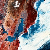
The Matusevich Glacier flows toward the coast of East Antarctica, pushing through a channel between the Lazarev Mountains…![View of Island of Kyushu, Japan from Skylab. Original from NASA. Digitally enhanced by rawpixel.]() View of Island of Kyushu, Japan from Skylab. Original from NASA. Digitally enhanced by rawpixel.
View of Island of Kyushu, Japan from Skylab. Original from NASA. Digitally enhanced by rawpixel.![The John F. Kennedy Space Center, America's spaceport, is located along Florida's eastern shore on Cape Canaveral. Original…]() The John F. Kennedy Space Center, America's spaceport, is located along Florida's eastern shore on Cape Canaveral. Original…
The John F. Kennedy Space Center, America's spaceport, is located along Florida's eastern shore on Cape Canaveral. Original…![Skylab 2 Farewell View from the Departing Skylab Command/Service Module. Original from NASA. Digitally enhanced by rawpixel.]() Skylab 2 Farewell View from the Departing Skylab Command/Service Module. Original from NASA. Digitally enhanced by rawpixel.
Skylab 2 Farewell View from the Departing Skylab Command/Service Module. Original from NASA. Digitally enhanced by rawpixel.![Mackenzie Bay, Antarctica and the ice shelf on February 12, 2012., Original from NASA. Digitally enhanced by rawpixel.]() Mackenzie Bay, Antarctica and the ice shelf on February 12, 2012., Original from NASA. Digitally enhanced by rawpixel.
Mackenzie Bay, Antarctica and the ice shelf on February 12, 2012., Original from NASA. Digitally enhanced by rawpixel.![Full Mir over New Zealand, from the space shuttle Atlantis, Russia's Mir Space Station. Original from NASA. Digitally…]() Full Mir over New Zealand, from the space shuttle Atlantis, Russia's Mir Space Station. Original from NASA. Digitally…
Full Mir over New Zealand, from the space shuttle Atlantis, Russia's Mir Space Station. Original from NASA. Digitally…![The Olympic National Park has to be one of America’s most diverse national park landscapes. Original from NASA.…]() The Olympic National Park has to be one of America’s most diverse national park landscapes. Original from NASA.…
The Olympic National Park has to be one of America’s most diverse national park landscapes. Original from NASA.…![Earth observations taken during STS-77 mission. Original from NASA. Digitally enhanced by rawpixel.]() Earth observations taken during STS-77 mission. Original from NASA. Digitally enhanced by rawpixel.
Earth observations taken during STS-77 mission. Original from NASA. Digitally enhanced by rawpixel.![Earth observations taken from Space Shuttle Columbia during STS-93 mission. Original from NASA. Digitally enhanced by…]() Earth observations taken from Space Shuttle Columbia during STS-93 mission. Original from NASA. Digitally enhanced by…
Earth observations taken from Space Shuttle Columbia during STS-93 mission. Original from NASA. Digitally enhanced by…![GOES 11 satellite image showing earth on March 25, 2010. Original from NASA. Digitally enhanced by rawpixel.]() GOES 11 satellite image showing earth on March 25, 2010. Original from NASA. Digitally enhanced by rawpixel.
GOES 11 satellite image showing earth on March 25, 2010. Original from NASA. Digitally enhanced by rawpixel.![A New Identity for Denali , North America’s highest peak. Original from NASA. Digitally enhanced by rawpixel.]() A New Identity for Denali , North America’s highest peak. Original from NASA. Digitally enhanced by rawpixel.
A New Identity for Denali , North America’s highest peak. Original from NASA. Digitally enhanced by rawpixel.![The three main ring sail parachutes of the Skylab 3 command module as they unfurl during descent to a successful splashdown…]() The three main ring sail parachutes of the Skylab 3 command module as they unfurl during descent to a successful splashdown…
The three main ring sail parachutes of the Skylab 3 command module as they unfurl during descent to a successful splashdown…![Earth observations of Houston taken by STS-115 crew member. Original from NASA. Digitally enhanced by rawpixel.]() Earth observations of Houston taken by STS-115 crew member. Original from NASA. Digitally enhanced by rawpixel.
Earth observations of Houston taken by STS-115 crew member. Original from NASA. Digitally enhanced by rawpixel.![Amazing image of the United States of America at night. Original from NASA. Digitally enhanced by rawpixel.]() Amazing image of the United States of America at night. Original from NASA. Digitally enhanced by rawpixel.
Amazing image of the United States of America at night. Original from NASA. Digitally enhanced by rawpixel.![NASA astronaut Scott Kelly captured this earth observation of the Caspian sea on July 27, 2015. Original from NASA.…]() NASA astronaut Scott Kelly captured this earth observation of the Caspian sea on July 27, 2015. Original from NASA.…
NASA astronaut Scott Kelly captured this earth observation of the Caspian sea on July 27, 2015. Original from NASA.…![The Larsen Ice Shelf in Antarctica viewed from NASA's DC-8 aircraft during the AirSAR 2004 campaign . Original from NASA.…]() The Larsen Ice Shelf in Antarctica viewed from NASA's DC-8 aircraft during the AirSAR 2004 campaign . Original from NASA.…
The Larsen Ice Shelf in Antarctica viewed from NASA's DC-8 aircraft during the AirSAR 2004 campaign . Original from NASA.…![Acadia National Park is one of the most visited parks in America. Original from NASA. Digitally enhanced by rawpixel.]() Acadia National Park is one of the most visited parks in America. Original from NASA. Digitally enhanced by rawpixel.
Acadia National Park is one of the most visited parks in America. Original from NASA. Digitally enhanced by rawpixel.![The Expedition 32 crew onboard the International Space Station, flying an altitude of approximately 240 miles, recorded a…]() The Expedition 32 crew onboard the International Space Station, flying an altitude of approximately 240 miles, recorded a…
The Expedition 32 crew onboard the International Space Station, flying an altitude of approximately 240 miles, recorded a…![The Mackenzie River in the Northwest Territories, Canada. Original from NASA. Digitally enhanced by rawpixel.]() The Mackenzie River in the Northwest Territories, Canada. Original from NASA. Digitally enhanced by rawpixel.
The Mackenzie River in the Northwest Territories, Canada. Original from NASA. Digitally enhanced by rawpixel.![Skylab 3, Skylab as the CM moves in for dockingOriginal from NASA. Digitally enhanced by rawpixel.]() Skylab 3, Skylab as the CM moves in for dockingOriginal from NASA. Digitally enhanced by rawpixel.
Skylab 3, Skylab as the CM moves in for dockingOriginal from NASA. Digitally enhanced by rawpixel.![Earth observation taken by the Expedition 43 crew ISS043. Original from NASA . Digitally enhanced by rawpixel.]() Earth observation taken by the Expedition 43 crew ISS043. Original from NASA . Digitally enhanced by rawpixel.
Earth observation taken by the Expedition 43 crew ISS043. Original from NASA . Digitally enhanced by rawpixel.![Typhoon Phanfone affecting Japan, on October 5, 2014. Original from NASA. Digitally enhanced by rawpixel.]() Typhoon Phanfone affecting Japan, on October 5, 2014. Original from NASA. Digitally enhanced by rawpixel.
Typhoon Phanfone affecting Japan, on October 5, 2014. Original from NASA. Digitally enhanced by rawpixel.![Eaarth observation of Ruapehu, New Zealand's North Island, one of the most active volcanoes in the South Pacific taken…]() Eaarth observation of Ruapehu, New Zealand's North Island, one of the most active volcanoes in the South Pacific taken…
Eaarth observation of Ruapehu, New Zealand's North Island, one of the most active volcanoes in the South Pacific taken…![View of a cloudy earth shown from space. This particular image portrays the average of all of the satellite's cloud…]() View of a cloudy earth shown from space. This particular image portrays the average of all of the satellite's cloud…
View of a cloudy earth shown from space. This particular image portrays the average of all of the satellite's cloud…![The Musandam Peninsula, part of Oman. Original from NASA. Digitally enhanced by rawpixel.]() The Musandam Peninsula, part of Oman. Original from NASA. Digitally enhanced by rawpixel.
The Musandam Peninsula, part of Oman. Original from NASA. Digitally enhanced by rawpixel.![Rising from fire and smoke, NASA's Juno planetary probe, enclosed in its payload fairing, launches atop a United Launch…]() Rising from fire and smoke, NASA's Juno planetary probe, enclosed in its payload fairing, launches atop a United Launch…
Rising from fire and smoke, NASA's Juno planetary probe, enclosed in its payload fairing, launches atop a United Launch…![On August 22, 2014 the Moderate Resolution Imaging Spectroradiometer aboard NASA’s Terra satellite captured a true…]() On August 22, 2014 the Moderate Resolution Imaging Spectroradiometer aboard NASA’s Terra satellite captured a true…
On August 22, 2014 the Moderate Resolution Imaging Spectroradiometer aboard NASA’s Terra satellite captured a true…![Hurricane Gonzalo's northern quadrant over Bermuda. Original from NASA. Digitally enhanced by rawpixel.]() Hurricane Gonzalo's northern quadrant over Bermuda. Original from NASA. Digitally enhanced by rawpixel.
Hurricane Gonzalo's northern quadrant over Bermuda. Original from NASA. Digitally enhanced by rawpixel.![Area of Indian Ocean just east of the island of Madagascar. Original from NASA. Digitally enhanced by rawpixel.]() Area of Indian Ocean just east of the island of Madagascar. Original from NASA. Digitally enhanced by rawpixel.
Area of Indian Ocean just east of the island of Madagascar. Original from NASA. Digitally enhanced by rawpixel.![NASA-NOAA's Suomi NPP Satellite Gets Colorful Look at Hurricane Blanca. Original from NASA. Digitally enhanced by rawpixel.]() NASA-NOAA's Suomi NPP Satellite Gets Colorful Look at Hurricane Blanca. Original from NASA. Digitally enhanced by rawpixel.
NASA-NOAA's Suomi NPP Satellite Gets Colorful Look at Hurricane Blanca. Original from NASA. Digitally enhanced by rawpixel.![The Lena River, some 2,800 miles long, is one of the largest rivers in the world. Original from NASA. Digitally enhanced by…]() The Lena River, some 2,800 miles long, is one of the largest rivers in the world. Original from NASA. Digitally enhanced by…
The Lena River, some 2,800 miles long, is one of the largest rivers in the world. Original from NASA. Digitally enhanced by…![Pyroclastic Flow Remnants at Shiveluch Volcano. Original from NASA. Digitally enhanced by rawpixel.]() Pyroclastic Flow Remnants at Shiveluch Volcano. Original from NASA. Digitally enhanced by rawpixel.
Pyroclastic Flow Remnants at Shiveluch Volcano. Original from NASA. Digitally enhanced by rawpixel.![Tropical Storm Isaac moving northwest through the Gulf of Mexico, with its eastern cloud covering over the entire state of…]() Tropical Storm Isaac moving northwest through the Gulf of Mexico, with its eastern cloud covering over the entire state of…
Tropical Storm Isaac moving northwest through the Gulf of Mexico, with its eastern cloud covering over the entire state of…![The world's largest bauxite mine found near Weipa, Queensland, Australia. Original from NASA. Digitally enhanced by rawpixel.]() The world's largest bauxite mine found near Weipa, Queensland, Australia. Original from NASA. Digitally enhanced by rawpixel.
The world's largest bauxite mine found near Weipa, Queensland, Australia. Original from NASA. Digitally enhanced by rawpixel.![The world largest bauxite mine found near Weipa, Queensland, Australia. Original from NASA. Digitally enhanced by rawpixel.]() The world largest bauxite mine found near Weipa, Queensland, Australia. Original from NASA. Digitally enhanced by rawpixel.
The world largest bauxite mine found near Weipa, Queensland, Australia. Original from NASA. Digitally enhanced by rawpixel.![Hurricane Matthew. This is a visible image of Major Hurricane Matthew taken from NASA's Terra satellite on Oct. 7 at 12 p.m.…]() Hurricane Matthew. This is a visible image of Major Hurricane Matthew taken from NASA's Terra satellite on Oct. 7 at 12 p.m.…
Hurricane Matthew. This is a visible image of Major Hurricane Matthew taken from NASA's Terra satellite on Oct. 7 at 12 p.m.…![Amazing image of the United States of America at night. Original from NASA. Digitally enhanced by rawpixel.]() Amazing image of the United States of America at night. Original from NASA. Digitally enhanced by rawpixel.
Amazing image of the United States of America at night. Original from NASA. Digitally enhanced by rawpixel.![Earth observation of North America tweeted out to social media fans of NASA astronaut Terry Virts who was on a 6 month…]() Earth observation of North America tweeted out to social media fans of NASA astronaut Terry Virts who was on a 6 month…
Earth observation of North America tweeted out to social media fans of NASA astronaut Terry Virts who was on a 6 month…![NASA and NOAA satellites are studying the triple tropical tempests that are now romping through the Eastern Pacific Ocean.…]() NASA and NOAA satellites are studying the triple tropical tempests that are now romping through the Eastern Pacific Ocean.…
NASA and NOAA satellites are studying the triple tropical tempests that are now romping through the Eastern Pacific Ocean.…![NASA's Terra Satellite catches powerful supertyphoon Megi. Original from NASA. Digitally enhanced by rawpixel.]() NASA's Terra Satellite catches powerful supertyphoon Megi. Original from NASA. Digitally enhanced by rawpixel.
NASA's Terra Satellite catches powerful supertyphoon Megi. Original from NASA. Digitally enhanced by rawpixel.![The Republic of Seychelles, an island country with an archipelago of 115 islands. Original from NASA. Digitally enhanced by…]() The Republic of Seychelles, an island country with an archipelago of 115 islands. Original from NASA. Digitally enhanced by…
The Republic of Seychelles, an island country with an archipelago of 115 islands. Original from NASA. Digitally enhanced by…![Oslo, the capital and largest city in Norway. Original from NASA. Digitally enhanced by rawpixel.]() Oslo, the capital and largest city in Norway. Original from NASA. Digitally enhanced by rawpixel.
Oslo, the capital and largest city in Norway. Original from NASA. Digitally enhanced by rawpixel.![The city of Chateaubriant, France. Original from NASA. Digitally enhanced by rawpixel.]() The city of Chateaubriant, France. Original from NASA. Digitally enhanced by rawpixel.
The city of Chateaubriant, France. Original from NASA. Digitally enhanced by rawpixel.![NASA Blue Marble 2007 West captured by the Moderate Resolution Imaging Spectroradiometer on NASA’s Terra satellite in…]() NASA Blue Marble 2007 West captured by the Moderate Resolution Imaging Spectroradiometer on NASA’s Terra satellite in…
NASA Blue Marble 2007 West captured by the Moderate Resolution Imaging Spectroradiometer on NASA’s Terra satellite in…![Satellite image of Earth. Original from NASA. Digitally enhanced by rawpixel.]() Satellite image of Earth. Original from NASA. Digitally enhanced by rawpixel.
Satellite image of Earth. Original from NASA. Digitally enhanced by rawpixel.![Nunavut, in northern Canada, the largest and newest federal territory of the country. Original from NASA. Digitally enhanced…]() Nunavut, in northern Canada, the largest and newest federal territory of the country. Original from NASA. Digitally enhanced…
Nunavut, in northern Canada, the largest and newest federal territory of the country. Original from NASA. Digitally enhanced…![The Jizzax Province in eastern Uzbekistan. Original from NASA. Digitally enhanced by rawpixel.]() The Jizzax Province in eastern Uzbekistan. Original from NASA. Digitally enhanced by rawpixel.
The Jizzax Province in eastern Uzbekistan. Original from NASA. Digitally enhanced by rawpixel.![Parts of the vast Ganges delta. Original from NASA. Digitally enhanced by rawpixel.]() Parts of the vast Ganges delta. Original from NASA. Digitally enhanced by rawpixel.
Parts of the vast Ganges delta. Original from NASA. Digitally enhanced by rawpixel.![The Indonesian islands of Komodo, Rintja, Padar, and Flores in the Komodo National Park. Original from NASA. Digitally…]() The Indonesian islands of Komodo, Rintja, Padar, and Flores in the Komodo National Park. Original from NASA. Digitally…
The Indonesian islands of Komodo, Rintja, Padar, and Flores in the Komodo National Park. Original from NASA. Digitally…![Satellite image of Earth. Original from NASA. Digitally enhanced by rawpixel.]() Satellite image of Earth. Original from NASA. Digitally enhanced by rawpixel.
Satellite image of Earth. Original from NASA. Digitally enhanced by rawpixel.![The Republic of Singapore, a city-state off the southern tip of the Malay Peninsula. Original from NASA. Digitally enhanced…]() The Republic of Singapore, a city-state off the southern tip of the Malay Peninsula. Original from NASA. Digitally enhanced…
The Republic of Singapore, a city-state off the southern tip of the Malay Peninsula. Original from NASA. Digitally enhanced…![The city of Sukkur, Pakistan. Original from NASA. Digitally enhanced by rawpixel.]() The city of Sukkur, Pakistan. Original from NASA. Digitally enhanced by rawpixel.
The city of Sukkur, Pakistan. Original from NASA. Digitally enhanced by rawpixel.![The western United States and Canada. Original from NASA. Digitally enhanced by rawpixel.]() The western United States and Canada. Original from NASA. Digitally enhanced by rawpixel.
The western United States and Canada. Original from NASA. Digitally enhanced by rawpixel.![The McMurdo Dry Valleys are a row of valleys west of McMurdo Sound, Antarctica. They are so named because of their extremely…]() The McMurdo Dry Valleys are a row of valleys west of McMurdo Sound, Antarctica. They are so named because of their extremely…
The McMurdo Dry Valleys are a row of valleys west of McMurdo Sound, Antarctica. They are so named because of their extremely…![Gaza Strip and the Mediterranean Sea from the Shuttle KidSat Camera. Original from NASA. Digitally enhanced by rawpixel.]() Gaza Strip and the Mediterranean Sea from the Shuttle KidSat Camera. Original from NASA. Digitally enhanced by rawpixel.
Gaza Strip and the Mediterranean Sea from the Shuttle KidSat Camera. Original from NASA. Digitally enhanced by rawpixel.![The Isle of Man. Original from NASA. Digitally enhanced by rawpixel.]() The Isle of Man. Original from NASA. Digitally enhanced by rawpixel.
The Isle of Man. Original from NASA. Digitally enhanced by rawpixel.![One-third of the Earth's sphere illuminated, Earth's terminator, sunglint, a portion of east Africa, as photographed from…]() One-third of the Earth's sphere illuminated, Earth's terminator, sunglint, a portion of east Africa, as photographed from…
One-third of the Earth's sphere illuminated, Earth's terminator, sunglint, a portion of east Africa, as photographed from…![NASA's Terra spacecraft captured this image of the city of Arkhangelsk and administrative capital of Archangelsk Oblast…]() NASA's Terra spacecraft captured this image of the city of Arkhangelsk and administrative capital of Archangelsk Oblast…
NASA's Terra spacecraft captured this image of the city of Arkhangelsk and administrative capital of Archangelsk Oblast…![Glacier Grey in front of The Cuernos del Paine mountains in Chile. Original from NASA. Digitally enhanced by rawpixel.]() Glacier Grey in front of The Cuernos del Paine mountains in Chile. Original from NASA. Digitally enhanced by rawpixel.
Glacier Grey in front of The Cuernos del Paine mountains in Chile. Original from NASA. Digitally enhanced by rawpixel.![Kamchatka Peninsula, Russia. Original from NASA. Digitally enhanced by rawpixel.]() Kamchatka Peninsula, Russia. Original from NASA. Digitally enhanced by rawpixel.
Kamchatka Peninsula, Russia. Original from NASA. Digitally enhanced by rawpixel.![Zircon mineral of 4.4 billion years old from a sedimentary gneiss in the Jack Hills of the Narre Gneiss Terrane of…]() Zircon mineral of 4.4 billion years old from a sedimentary gneiss in the Jack Hills of the Narre Gneiss Terrane of…
Zircon mineral of 4.4 billion years old from a sedimentary gneiss in the Jack Hills of the Narre Gneiss Terrane of…![Parts of he Kimberley region of Western Australia. Original from NASA. Digitally enhanced by rawpixel.]() Parts of he Kimberley region of Western Australia. Original from NASA. Digitally enhanced by rawpixel.
Parts of he Kimberley region of Western Australia. Original from NASA. Digitally enhanced by rawpixel.![Earth, globe clipart, planet surface]() Earth, globe clipart, planet surface
Earth, globe clipart, planet surface ![Earth, globe clipart, planet surface]() Earth, globe clipart, planet surface
Earth, globe clipart, planet surface ![NASA astronaut Scott Kelly, on board the International Space Station, took this interesting picture of the Himalayas on Aug…]() NASA astronaut Scott Kelly, on board the International Space Station, took this interesting picture of the Himalayas on Aug…
NASA astronaut Scott Kelly, on board the International Space Station, took this interesting picture of the Himalayas on Aug…![A perfect sunset over NASA's Kennedy Space Center in Florida. Original from NASA. Digitally enhanced by rawpixel.]() A perfect sunset over NASA's Kennedy Space Center in Florida. Original from NASA. Digitally enhanced by rawpixel.
A perfect sunset over NASA's Kennedy Space Center in Florida. Original from NASA. Digitally enhanced by rawpixel.![The deep waters of the Tongue of the Ocean and the completely submerged Grand Bahama Bank. Original from NASA. Digitally…]() The deep waters of the Tongue of the Ocean and the completely submerged Grand Bahama Bank. Original from NASA. Digitally…
The deep waters of the Tongue of the Ocean and the completely submerged Grand Bahama Bank. Original from NASA. Digitally…![Impact of Northern California fires seen in new NASA satellite image. Original from NASA. Digitally enhanced by rawpixel.]() Impact of Northern California fires seen in new NASA satellite image. Original from NASA. Digitally enhanced by rawpixel.
Impact of Northern California fires seen in new NASA satellite image. Original from NASA. Digitally enhanced by rawpixel.![NASA/Goddard Space Flight Center/Reto Stöckli's amazingly beautiful view of Earth from space. October 9th, 2007.…]() NASA/Goddard Space Flight Center/Reto Stöckli's amazingly beautiful view of Earth from space. October 9th, 2007.…
NASA/Goddard Space Flight Center/Reto Stöckli's amazingly beautiful view of Earth from space. October 9th, 2007.…![View of Earth, showing Africa, Europe and Asia taken from the Apollo 11 spacecraft during its trans-lunar coast toward the…]() View of Earth, showing Africa, Europe and Asia taken from the Apollo 11 spacecraft during its trans-lunar coast toward the…
View of Earth, showing Africa, Europe and Asia taken from the Apollo 11 spacecraft during its trans-lunar coast toward the…![Earth, globe sticker, planet surface psd]() Earth, globe sticker, planet surface psd
Earth, globe sticker, planet surface psd![Aaland archipelago at the mouth of the Gulf of Bothnia which belongs to Finland. Original from NASA. Digitally enhanced by…]() Aaland archipelago at the mouth of the Gulf of Bothnia which belongs to Finland. Original from NASA. Digitally enhanced by…
Aaland archipelago at the mouth of the Gulf of Bothnia which belongs to Finland. Original from NASA. Digitally enhanced by…![Flood waters in Bangkok as the Ayutthaya River overflowed its banks. Original from NASA. Digitally enhanced by rawpixel.]() Flood waters in Bangkok as the Ayutthaya River overflowed its banks. Original from NASA. Digitally enhanced by rawpixel.
Flood waters in Bangkok as the Ayutthaya River overflowed its banks. Original from NASA. Digitally enhanced by rawpixel.![Delhi, the second largest metropolis in India, with a population of 16 million. Original from NASA. Digitally enhanced by…]() Delhi, the second largest metropolis in India, with a population of 16 million. Original from NASA. Digitally enhanced by…
Delhi, the second largest metropolis in India, with a population of 16 million. Original from NASA. Digitally enhanced by…![Image of Europe, Africa, and the Middle East at night. Original from NASA. Digitally enhanced by rawpixel.]() Image of Europe, Africa, and the Middle East at night. Original from NASA. Digitally enhanced by rawpixel.
Image of Europe, Africa, and the Middle East at night. Original from NASA. Digitally enhanced by rawpixel.![L'Anse aux Meadows is a site on the northernmost tip of the island of Newfoundland. Original from NASA. Digitally enhanced…]() L'Anse aux Meadows is a site on the northernmost tip of the island of Newfoundland. Original from NASA. Digitally enhanced…
L'Anse aux Meadows is a site on the northernmost tip of the island of Newfoundland. Original from NASA. Digitally enhanced…![A perfect sunset over NASA's Kennedy Space Center in Florida. Original from NASA. Digitally enhanced by rawpixel.]() A perfect sunset over NASA's Kennedy Space Center in Florida. Original from NASA. Digitally enhanced by rawpixel.
A perfect sunset over NASA's Kennedy Space Center in Florida. Original from NASA. Digitally enhanced by rawpixel.![A perfect sunset over NASA's Kennedy Space Center in Florida. Original from NASA. Digitally enhanced by rawpixel.]() A perfect sunset over NASA's Kennedy Space Center in Florida. Original from NASA. Digitally enhanced by rawpixel.
A perfect sunset over NASA's Kennedy Space Center in Florida. Original from NASA. Digitally enhanced by rawpixel.![NASA Shuttle Radar Topography Mission imaged Sendai, the capital city of Japan Miyagi Prefecture a magnitude 8.9 earthquake…]() NASA Shuttle Radar Topography Mission imaged Sendai, the capital city of Japan Miyagi Prefecture a magnitude 8.9 earthquake…
NASA Shuttle Radar Topography Mission imaged Sendai, the capital city of Japan Miyagi Prefecture a magnitude 8.9 earthquake…![Cloud vortices off Madeira and Canary Islands. Original from NASA. Digitally enhanced by rawpixel.]() Cloud vortices off Madeira and Canary Islands. Original from NASA. Digitally enhanced by rawpixel.
Cloud vortices off Madeira and Canary Islands. Original from NASA. Digitally enhanced by rawpixel.![Artist's concept of the Skylab in orbit. Original from NASA. Digitally enhanced by rawpixel.]() Artist's concept of the Skylab in orbit. Original from NASA. Digitally enhanced by rawpixel.
Artist's concept of the Skylab in orbit. Original from NASA. Digitally enhanced by rawpixel.![Earth, globe clipart, planet surface on off white]() Earth, globe clipart, planet surface on off white
Earth, globe clipart, planet surface on off white![Earth, globe sticker, planet surface psd]() Earth, globe sticker, planet surface psd
Earth, globe sticker, planet surface psd![Edge of an ice shelf in Adelaide Island, off the Antarctic Peninsula. Original from NASA. Digitally enhanced by rawpixel.]() Edge of an ice shelf in Adelaide Island, off the Antarctic Peninsula. Original from NASA. Digitally enhanced by rawpixel.
Edge of an ice shelf in Adelaide Island, off the Antarctic Peninsula. Original from NASA. Digitally enhanced by rawpixel.![A NASA scientific balloon awaits launch in McMurdo, Antarctica. Original from NASA. Digitally enhanced by rawpixel.]() A NASA scientific balloon awaits launch in McMurdo, Antarctica. Original from NASA. Digitally enhanced by rawpixel.
A NASA scientific balloon awaits launch in McMurdo, Antarctica. Original from NASA. Digitally enhanced by rawpixel.![Images of the Earth's land surface and surrounding coastal regions. Original from NASA. Digitally enhanced by rawpixel.]() Images of the Earth's land surface and surrounding coastal regions. Original from NASA. Digitally enhanced by rawpixel.
Images of the Earth's land surface and surrounding coastal regions. Original from NASA. Digitally enhanced by rawpixel.![Astronaut Owen K. Garriott, Skylab 3 science pilot, retrieves an imagery experiment from the Apollo Telescope Mount (ATM)…]() Astronaut Owen K. Garriott, Skylab 3 science pilot, retrieves an imagery experiment from the Apollo Telescope Mount (ATM)…
Astronaut Owen K. Garriott, Skylab 3 science pilot, retrieves an imagery experiment from the Apollo Telescope Mount (ATM)…![Guangxi Province in southeast China. Original from NASA. Digitally enhanced by rawpixel.]() Guangxi Province in southeast China. Original from NASA. Digitally enhanced by rawpixel.
Guangxi Province in southeast China. Original from NASA. Digitally enhanced by rawpixel.![The flooding from the Chao Phraya River, Thailand on Nov. 17, 2011. Original from NASA. Digitally enhanced by rawpixel.]() The flooding from the Chao Phraya River, Thailand on Nov. 17, 2011. Original from NASA. Digitally enhanced by rawpixel.
The flooding from the Chao Phraya River, Thailand on Nov. 17, 2011. Original from NASA. Digitally enhanced by rawpixel.![Flooding from the Chao Phraya River, Thailand on Nov. 1, 2011. Original from NASA. Digitally enhanced by rawpixel.]() Flooding from the Chao Phraya River, Thailand on Nov. 1, 2011. Original from NASA. Digitally enhanced by rawpixel.
Flooding from the Chao Phraya River, Thailand on Nov. 1, 2011. Original from NASA. Digitally enhanced by rawpixel.